ကြိုဆိုပါတယ်။ / Welcome to the Myanmar Portal 

Myanmar, officially the Republic of the Union of Myanmar and also known as Burma (the official name until 1989), is a country in Southeast Asia. It is the largest country by area in Mainland Southeast Asia and has a population of about 55 million. It is bordered by Bangladesh and India to its northwest, China to its northeast, Laos and Thailand to its east and southeast, and the Andaman Sea and the Bay of Bengal to its south and southwest. The country's capital city is Naypyidaw, and its largest city is Yangon (formerly Rangoon).
Myanmar is a member of the East Asia Summit, Non-Aligned Movement, ASEAN, and BIMSTEC, but it is not a member of the Commonwealth of Nations despite once being part of the British Empire. Myanmar is a Dialogue Partner of the Shanghai Cooperation Organization. The country is very rich in natural resources, such as jade, gems, oil, natural gas, teak and other minerals, as well as also endowed with renewable energy, having the highest solar power potential compared to other countries of the Great Mekong Subregion. However, Myanmar has long suffered from instability, factional violence, corruption, poor infrastructure, as well as a long history of colonial exploitation with little regard to human development. In 2013, its GDP (nominal) stood at US$56.7 billion and its GDP (PPP) at US$221.5 billion. The income gap in Myanmar is among the widest in the world, as a large proportion of the economy is controlled by cronies of the military junta. Myanmar is one of the least developed countries; as of 2020, according to the Human Development Index, it ranks 147 out of 189 countries in terms of human development, the lowest in Southeast Asia. Since 2021, more than 600,000 people were displaced across Myanmar due to the surge in violence post-coup, with more than 3 million people in dire need of humanitarian assistance. (Full article...)
Selected articles -
-


General elections were held in Myanmar on 7 November 2010, in accordance with the new constitution, which was approved in a referendum held in May 2008. The election date was announced by the State Peace and Development Council (SPDC) on 13 August.
The elections were the fifth step of the seven-step "roadmap to democracy" proposed by the SPDC in 2003, the sixth and seventh steps being the convening of elected representatives and the building of a modern, democratic nation, respectively. However, the National League for Democracy boycotted the elections. The result was a sweeping victory for the Union Solidarity and Development Party, which won nearly 80% of seats contested across the upper and lower houses. The United Nations expressed concern about the fairness of the elections, and western countries dismissed them as fraudulent. (Full article...) -
General elections were held in Myanmar on 8 November 2015, with the National League for Democracy winning a supermajority of seats in the combined national parliament. Voting occurred in all constituencies, excluding seats appointed by the military, to select Members of Assembly to seats in both the upper house (the House of Nationalities) and the lower house (the House of Representatives) of the Assembly of the Union, and State and Region Hluttaws. Ethnic Affairs Ministers were also elected by their designated electorates on the same day, although only select ethnic minorities in particular states and regions were entitled to vote for them.
These polls were the first openly contested election held in the country since 1990, which was annulled by the military government after the National League for Democracy's (NLD) victory. The poll was preceded by the 2010 general election, which was marred by a boycott and widespread allegations of systematic fraud by the victorious Union Solidarity and Development Party (USDP). (Full article...) -
Hkakaborazi National Park is a national park in northern Myanmar with an area of 1,472 sq mi (3,810 km2). It was established in 1998.
It surrounds Hkakabo Razi, the highest mountain in the country.
It ranges in elevation from 2,950 to 18,730 ft (900 to 5,710 m) comprising evergreen forest and mixed deciduous forests in Nogmung Township, Kachin State. It is managed by the Nature and Wildlife Conservation Division.
It is contiguous with Bumhpa Bum Wildlife Sanctuary and Hukaung Valley Wildlife Sanctuary. These protected areas together with Hponkanrazi Wildlife Sanctuary comprise the largest continuous expanse of natural forest called the Northern Forest Complex stretching over an area of 11,624 sq mi (30,110 km2). Its objective is to conserve the biodiversity of the Ayeyarwady and Chindwin river basins. (Full article...) -
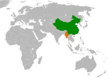
China–Myanmar relations (Chinese: 中缅关系; Burmese: တရုတ်မြန်မာဆက်ဆံရေး) are the international relations between the People's Republic of China and Myanmar. China and Myanmar have active bilateral relations with each other. The relation is often described as a pauk-phaw relationship (Burmese: ပေါက်ဖော်), based a Burmese term for kinsfolk that implicates special asymmetric obligations between the two countries.
Generally, China has maintained positive relationships with both military and elected governments in Myanmar. Bilateral relations between China and Myanmar have also faced difficulties due to alleged Chinese backing of rebels in Myanmar's territories. In recent years, the relations between China and Myanmar have faced some problems due to ongoing clashes between ethnic Chinese rebels and the Myanmar military near the China–Myanmar border. (Full article...) -
The Tenasserim Hills or Tenasserim Range (Burmese: တနင်္သာရီ တောင်တန်း, [tənɪ̀ɰ̃θàjì tàʊɰ̃dáɰ̃]; Thai: ทิวเขาตะนาวศรี, RTGS: Thio Khao Tanao Si, pronounced [tʰīw kʰǎw tā.nāːw sǐː]; Malay: Banjaran Tanah Seri/Banjaran Tenang Sari) is the geographical name of a roughly 1,700 km long mountain chain, part of the Indo-Malayan mountain system in Southeast Asia.
Despite their relatively scant altitude these mountains form an effective barrier between Thailand and Myanmar in their northern and central region. There are only two main transnational roads and cross-border points between Kanchanaburi and Tak, at the Three Pagodas Pass and at Mae Sot. The latter is located beyond the northern end of the range, where the Tenasserim Hills meet the Dawna Range. Minor cross-border points are Sing Khon, near Prachuap Khiri Khan, as well as Bong Ti and Phu Nam Ron west of Kanchanaburi. The latter is expected to gain in importance if the planned Dawei Port Project goes ahead, along with a highway and a railway line between Bangkok and that harbor. (Full article...) -
Dein Mani-Yut (Mon: ဒိန်ၝိတ်ရတ်; Burmese: ဒိန်မဏိရွတ်, Burmese pronunciation: [dèiɴ mənḭ jʊ̯ʔ]), commonly known as Amat Dein (အမတ်ဒိန်, "Minister Dein") or as Amat Tein (အမတ်တိန်, "Minister Tein"), was co-chief minister of Hanthawaddy during the reign of King Razadarit (1384–1421). He was also a senior general, and held key governorship posts at Syriam (1370s–1408), Bassein (1408–1415) and Sittaung (1415–1420s). Along with his colleague Byat Za, Dein was instrumental in Razadarit's reunification campaigns of the Mon-speaking kingdom in the late 1380s, as well as the Forty Years' War against the Burmese-speaking Ava Kingdom. (Full article...)
-
Burmese Days is the first novel by English writer George Orwell, published in 1934. Set in British Burma during the waning days of empire, when Burma was ruled from Delhi as part of British India, the novel serves as "a portrait of the dark side of the British Raj." At the centre of the novel is John Flory, "the lone and lacking individual trapped within a bigger system that is undermining the better side of human nature." The novel describes "both indigenous corruption and imperial bigotry" in a society where, "after all, natives were natives—interesting, no doubt, but finally...an inferior people".
Burmese Days was first published "further afield," in the United States, because of concerns that it might be potentially libelous; that the real provincial town of Katha had been described too realistically; and that some of its fictional characters were based too closely on identifiable people. A British edition, with altered names, appeared a year later. Nonetheless, Orwell's harsh portrayal of colonial society was felt by "some old Burma hands" to have "rather let the side down". In a letter from 1946, Orwell wrote, "I dare say it's unfair in some ways and inaccurate in some details, but much of it is simply reporting what I have seen". (Full article...) -
The 1962 Burmese coup d'état marked the beginning of one-party rule in Burma (Myanmar) and the political dominance of the military in Burmese politics. In the 2 March 1962 coup, the military replaced the civilian AFPFL-government headed by Prime Minister U Nu, along with the Union Revolutionary Council Chaired by General Ne Win.
In the first 12 years following the coup, the country was ruled under martial law, and saw a significant expansion in the military's role in the national economy, politics, and state bureaucracy. Following the constitution of 1974, the Revolutionary Council handed over the power to the elected government, consisting of a single-party, the Burma Socialist Programme Party, which had been founded by the council in 1962. The elected government remained hybrid between civilian and military, until 18 September 1988, when the military again took over as the State Law and Order Restoration Council (then renamed the State Peace and Development Council) following the nationwide 8888 Uprising and virtual breakdown of the socialist regime. The military junta retained power for 23 years until 2011, when it was transferred to the Union Solidarity and Development Party. (Full article...) -
The Andaman Sea (historically also known as the Burma Sea) is a marginal sea of the northeastern Indian Ocean bounded by the coastlines of Myanmar and Thailand along the Gulf of Martaban and the west side of the Malay Peninsula, and separated from the Bay of Bengal to its west by the Andaman Islands and the Nicobar Islands. Its southern end is at Breueh Island just north of Sumatra, with the Strait of Malacca further southeast.
Traditionally, the sea has been used for fishery and transportation of goods between the coastal countries and its coral reefs and islands are popular tourist destinations. The fishery and tourist infrastructure was severely damaged by the December 2004 Indian Ocean earthquake and tsunami. (Full article...) -
The history of Myanmar (also known as Burma; Burmese: မြန်မာ့သမိုင်း) covers the period from the time of first-known human settlements 13,000 years ago to the present day. The earliest inhabitants of recorded history were a Tibeto-Burman-speaking people who established the Pyu city-states ranged as far south as Pyay and adopted Theravada Buddhism.
Another group, the Bamar people, entered the upper Irrawaddy valley in the early 9th century. They went on to establish the Pagan Kingdom (1044–1297), the first-ever unification of the Irrawaddy valley and its periphery. The Burmese language and culture slowly came to replace Pyu norms during this period. After the First Mongol invasion of Burma in 1287, several small kingdoms, of which the Kingdom of Ava, the Hanthawaddy Kingdom, the Kingdom of Mrauk U and the Shan States were principal powers, came to dominate the landscape, replete with ever-shifting alliances and constant wars. (Full article...)


Did you know (auto-generated) -

- ... that squatters in Myanmar were punished for protesting against the 2021 coup d'état by being evicted?
- ... that Maung O, Prince of Salin, and his sister Nanmadaw Me Nu became de facto rulers of Burma when King Bagyidaw was suffering from depression?
- ... that the Myanmar Photo Archive (example photograph shown) revealed "a side of modern Myanmar that, until very recently, remained hidden in dusty attics"?
- ... that the talabaw soup, which consists primarily of bamboo shoots, is the essential dish of Myanmar's Karen people, who use it to supplement rice?
- ... that as part of the coronation of Mindon Min, the square yuzana around the capital was designated a sanctuary?
- ... that Rangoon kept its own time for more than two decades after Burma Standard Time first came into effect?
- ... that the Myanmar Coast Guard was initially proposed as a civilian law enforcement agency before being established as a branch of the military three years later?
- ... that clashes between the Myanmar military and local armed groups broke out in Lay Kay Kaw six years after it was established as a "town of peace" between the parties?
Related portals and projects
General images -
-
 British soldiers remove their shoes at the entrance of Shwedagon Pagoda. To the left, a sign reads "Foot wearing is strictly prohibited" in Burmese, English, Tamil, and Urdu. (from Culture of Myanmar)
 -

-
 A bull fight, 19th-century watercolour (from Culture of Myanmar)
 -

-
 Temples at Mrauk U, was the capital of the Mrauk U Kingdom, which ruled over what is now Rakhine State. (from History of Myanmar)
 -
 Sculpture of Myanmar mythical lion (from Culture of Myanmar)
 -
 19th-century funeral cart and spire, which would form part of the procession from the home to the place of cremation (from Culture of Myanmar)
 -
 Protesters in Yangon with a banner that reads non-violence: national movement in Burmese, in the background is Shwedagon Pagoda. (from History of Myanmar)
 -
 Aerial view of a burned Rohingya village in Rakhine state, Myanmar, September 2017 (from History of Myanmar)
 -
 The restored Taungoo or Nyaungyan dynasty c. 1650 CE. (from History of Myanmar)
 -
 Former US President Barack Obama poses barefoot on the grounds of Shwedagon Pagoda, one of Myanmar's major Buddhist pilgrimage sites. (from Culture of Myanmar)
 -
 Vegetable stall on the roadside at the Madras Lancer Lines, Mandalay, January 1886. Photographer: Hooper, Willoughby Wallace (1837–1912). (from History of Myanmar)
 -
 A wedding procession, with the groom and bride dressed in traditional Burmese wedding clothes, reminiscent of royal attire (from Culture of Myanmar)
 -
 Jade Mine in Hpakant (from Geography of Myanmar)
 -
 The paddle steamer Ramapoora (right) of the British India Steam Navigation Company on the Rangoon river having just arrived from Moulmein. 1895. Photographers: Watts and Skeen (from History of Myanmar)
 -
 Portuguese ruler and soldiers mounting an Elephant. Philips, Jan Caspar (draughtsman and engraver) (from History of Myanmar)
 -

-
 A group of Buddhist worshipers at Shwedagon Pagoda, an important religious site for Burmese Buddhists (from Culture of Myanmar)
 -
 Pagan Kingdom during Narapatisithu's reign. Burmese chronicles also claim Kengtung and Chiang Mai. Core areas shown in darker yellow. Peripheral areas in light yellow. Pagan incorporated key ports of Lower Burma into its core administration by the 13th century. (from History of Myanmar)
 -
 Mountains near Pindaya on the Shan Plateau (from Geography of Myanmar)
 -
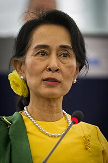
 Aung San Suu Kyi addresses crowds at the NLD headquarters shortly after her release. (from History of Myanmar)
 -
 Recorder's Court on Sule Pagoda Road, with the Sule Pagoda at the far end, Rangoon, 1868. Photographer: J. Jackson. (from History of Myanmar)
 -
 Two female musicians play the saung at a performance in Mandalay. (from Culture of Myanmar)
 -
 A theatrical performance of the Mon dance (from Culture of Myanmar)
 -
 Myinhkin thabin - equestrian sport (from Culture of Myanmar)
 -
 Boxing match, 19th-century watercolour (from Culture of Myanmar)
 -

-
 Grandfather Island, Dawei (from Geography of Myanmar)
 -
 Saint Mary's Cathedral in Downtown Yangon is the largest Roman Catholic cathedral in Burma. (from Culture of Myanmar)
 -
 Political Map of Burma (Myanmar) c. 1450 CE. (from History of Myanmar)
 -
 A wide range of Burmese lacquerware from Bagan (from Culture of Myanmar)
 -
 Mount Popa, a dormant volcano in the Central Lowlands (from Geography of Myanmar)
 -
 Salween river at Mae Sam Laep on the Thai-Myanmar border (from Geography of Myanmar)
 -
 British soldiers dismantling cannons belonging to King Thibaw's forces, Third Anglo-Burmese War, Ava, 27 November 1885. Photographer: Hooper, Willoughby Wallace (1837–1912). (from History of Myanmar)
 -
 Myanmar (Burma) map of Köppen climate classification (from Geography of Myanmar)
 -
 Hlei pyaingbwè - a Burmese regatta (from Culture of Myanmar)
 -
 The shores of Irrawaddy River at Nyaung-U, Bagan (from Geography of Myanmar)
 -
 Protesters in Yangon carrying signs reading "Free Daw Aung San Suu Kyi" on 8 February 2021. (from History of Myanmar)
 -
 A large fracture on the Mingun Pahtodawgyi caused by the 1839 Ava earthquake. (from Geography of Myanmar)
 -
 British soldiers on patrol in the ruins of the Burmese town of Bahe during the advance on Mandalay, January 1945. (from History of Myanmar)


_headquarter.jpg)


Major topics
Categories

More topics

Associated Wikimedia
The following Wikimedia Foundation sister projects provide more on this subject:
-
 Commons
Free media repository -
 Wikibooks
Free textbooks and manuals -
 Wikidata
Free knowledge base -
 Wikinews
Free-content news -
 Wikiquote
Collection of quotations -
 Wikisource
Free-content library -
 Wikiversity
Free learning tools -
 Wikivoyage
Free travel guide -
 Wiktionary
Dictionary and thesaurus


