The World Portal


The world is the totality of entities, the whole of reality, or everything that exists. The nature of the world has been conceptualized differently in different fields. Some conceptions see the world as unique while others talk of a "plurality of worlds". Some treat the world as one simple object while others analyze the world as a complex made up of parts.
In scientific cosmology, the world or universe is commonly defined as "[t]he totality of all space and time; all that is, has been, and will be". Theories of modality talk of possible worlds as complete and consistent ways how things could have been. Phenomenology, starting from the horizon of co-given objects present in the periphery of every experience, defines the world as the biggest horizon or the "horizon of all horizons". In philosophy of mind, the world is contrasted with the mind as that which is represented by the mind. Theology conceptualizes the world in relation to God, for example, as God's creation, as identical to God or as the two being interdependent. In religions, there is a tendency to downgrade the material or sensory world in favor of a spiritual world to be sought through religious practice. A comprehensive representation of the world and our place in it, as is found in religions, is known as a worldview. Cosmogony is the field that studies the origin or creation of the world while eschatology refers to the science or doctrine of the last things or of the end of the world.
In various contexts, the term "world" takes a more restricted meaning associated, for example, with the Earth and all life on it, with humanity as a whole or with an international or intercontinental scope. In this sense, world history refers to the history of humanity as a whole and world politics is the discipline of political science studying issues that transcend nations and continents. Other examples include terms such as "world religion", "world language", "world government", "world war", "world population", "world economy", or "world championship". (Full article...)
Selected articles -
-


Laws concerning gender identity-expression by country or territory Legal identity change, surgery requiredNo legal identity changeUnknown/Ambiguous
Rights affecting lesbian, gay, bisexual, and transgender (LGBT) people vary greatly by country or jurisdiction—encompassing everything from the legal recognition of same-sex marriage to the death penalty for homosexuality.
Notably, , 36 countries recognize same-sex marriage. By contrast, not counting non-state actors and extrajudicial killings, only two countries are believed to impose the death penalty on consensual same-sex sexual acts: Iran and Afghanistan. The death penalty is officially law, but generally not practiced, in Mauritania, Saudi Arabia, Somalia (in the autonomous state of Jubaland) and the United Arab Emirates. LGBT people also face extrajudicial killings in the Russian region of Chechnya. Sudan rescinded its unenforced death penalty for anal sex (hetero- or homosexual) in 2020. Fifteen countries have stoning on the books as a penalty for adultery, which (in light of the illegality of gay marriage in those countries) would by default include gay sex, but this is enforced by the legal authorities in Iran and Nigeria (in the northern third of the country). (Full article...) -
Post-Kyoto negotiations refers to high level talks attempting to address global warming by limiting greenhouse gas emissions. Generally part of the United Nations Framework Convention on Climate Change (UNFCCC), these talks concern the period after the first "commitment period" of the Kyoto Protocol, which expired at the end of 2012. Negotiations have been mandated by the adoption of the Bali Road Map and Decision 1/CP.13 ("The Bali Action Plan").
UNFCCC negotiations are conducted within two subsidiary bodies, the Ad Hoc Working Group on Long-term Cooperative Action under the Convention (AWG-LCA) and the Ad Hoc Working Group on Further Commitments for Annex I Parties under the Kyoto Protocol (AWG-KP) and were expected to culminate in the United Nations Climate Change Conference taking place in December 2009 in Copenhagen (COP-15); negotiations are supported by a number of external processes, including the G8 process, a number of regional meetings and the Major Economies Forum on Energy and Climate that was launched by US President Barack Obama in March 2009. High level talks were held at the meeting of the G8+5 Climate Change Dialogue in February 2007 and at a number of subsequent G8 meetings, most recently leading to the adoption of the G8 leaders declaration "Responsible Leadership for a Sustainable Future" during the G8 summit in L´Aquila, Italy, in July 2009. (Full article...) -
The aftermath of World War II saw the rise of two global superpowers, the Soviet Union (USSR) and the United States (US). The aftermath of World War II was also defined by the rising threat of nuclear warfare, the creation and implementation of the United Nations as an intergovernmental organization, and the decolonization of Asia and Africa by European and East Asian powers, most notably by the United Kingdom, France, and Japan.
Once allies during World War II, the United States and the Soviet Union became competitors on the world stage and engaged in the Cold War, so called because it never resulted in overt, declared total war between the two powers. It was instead characterized by espionage, political subversion and proxy wars. Western Europe and Asia were rebuilt through the American Marshall Plan, whereas Central and Eastern Europe fell under the Soviet sphere of influence and eventually behind an "Iron Curtain". Europe was divided into a US-led Western Bloc and a USSR-led Eastern Bloc. Internationally, alliances with the two blocs gradually shifted, with some nations trying to stay out of the Cold War through the Non-Aligned Movement. The war also saw a nuclear arms race between the two superpowers; part of the reason that the Cold War never became a "hot" war was that the Soviet Union and the United States had nuclear deterrents against each other, leading to a mutually assured destruction standoff. (Full article...) -
The Space Age is a period encompassing the activities related to the space race, space exploration, space technology, and the cultural developments influenced by these events, beginning with the launch of Sputnik 1 on October 4, 1957, and continuing to the present.
This period is characterized by changes in emphasis on particular areas of space exploration and applications. Initially, the United States and the Soviet Union invested unprecedented amounts of resources in breaking records and being first to meet milestones in crewed and uncrewed exploration. The United States established the National Aeronautics and Space Administration (NASA) and the USSR established the Kosmicheskaya programma SSSR to meet these goals. This period of competition gave way to cooperation between those nations and emphasis on scientific research and commercial applications of space-based technology. (Full article...) -
The United Nations Climate Change Conferences are yearly conferences held in the framework of the United Nations Framework Convention on Climate Change (UNFCCC). They serve as the formal meeting of the UNFCCC parties – the Conference of the Parties (COP) – to assess progress in dealing with climate change, and beginning in the mid-1990s, to negotiate the Kyoto Protocol to establish legally binding obligations for developed countries to reduce their greenhouse gas emissions. Starting in 2005 the conferences have also served as the "Conference of the Parties Serving as the Meeting of Parties to the Kyoto Protocol" (CMP); also parties to the convention that are not parties to the protocol can participate in protocol-related meetings as observers. From 2011 to 2015 the meetings were used to negotiate the Paris Agreement as part of the Durban platform, which created a general path towards climate action. Any final text of a COP must be agreed by consensus.
The first UN Climate Change Conference was held in 1995 in Berlin. (Full article...) -
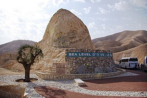
This marker indicating sea level is situated between Jerusalem and the Dead Sea.
Mean sea level (MSL, often shortened to sea level) is an average surface level of one or more among Earth's coastal bodies of water from which heights such as elevation may be measured. The global MSL is a type of vertical datum – a standardised geodetic datum – that is used, for example, as a chart datum in cartography and marine navigation, or, in aviation, as the standard sea level at which atmospheric pressure is measured to calibrate altitude and, consequently, aircraft flight levels. A common and relatively straightforward mean sea-level standard is instead a long-term average of tide gauge readings at a particular reference location.
Sea levels can be affected by many factors and are known to have varied greatly over geological time scales. Current sea level rise is mainly caused by human-induced climate change. When temperatures rise, mountain glaciers and polar ice sheets melt, increasing the amount of water in the oceans, while the existing seawater also expands with heat. Because most of human settlement and infrastructure was built in response to a more-normalized sea level with limited expected change, populations affected by sea level rise will need to invest in climate adaptation to mitigate the worst effects or, when populations are at extreme risk, a process of managed retreat. (Full article...) -
The Paris Agreement (or Paris Accords, Paris Climate Accords) is an international treaty on climate change that was adopted in 2015. The treaty covers climate change mitigation, adaptation, and finance. The Paris Agreement was negotiated by 196 parties at the 2015 United Nations Climate Change Conference near Paris, France. As of February 2023, 195 members of the United Nations Framework Convention on Climate Change (UNFCCC) are parties to the agreement. Of the three UNFCCC member states which have not ratified the agreement, the only major emitter is Iran. The United States withdrew from the agreement in 2020, but rejoined in 2021.
The Paris Agreement has a long-term temperature goal which is to keep the rise in global surface temperature to well below 2 °C (3.6 °F) above pre-industrial levels. The treaty also states that preferably the limit of the increase should only be 1.5 °C (2.7 °F). The lower the temperature increase, the smaller the effects of climate change can expected to be. To achieve this temperature goal, greenhouse gas emissions should be reduced as soon as, and by as much as, possible. They should even reach net zero by the middle of the 21st century. To stay below 1.5 °C of global warming, emissions need to be cut by roughly 50% by 2030. This figure takes into account each country's documented pledges. (Full article...)


.jpg)

General images -
-
 Taj Mahal, Mughal Empire, India
 -
 Satellite time lapse imagery of Earth's rotation showing axis tilt (from Earth)
 -
 Cross-section through a liposome (from History of Earth)
 -

-

-
 Angkor Wat temple complex, Cambodia, early 12th century
 -
 Artist's impression of the enormous collision that probably formed the Moon (from History of Earth)
 -
 Map of peopling of the world (Southern Dispersal paradigm), in thousands of years ago.
 -
 The pale orange dot, an artist's impression of the early Earth which might have appeared orange through its hazy methane rich prebiotic second atmosphere. Earth's atmosphere at this stage was somewhat comparable to today's atmosphere of Titan. (from History of Earth)
 -
 Vitruvian Man by Leonardo da Vinci epitomizes the advances in art and science seen during the Renaissance. (from History of Earth)
 -

-
 Tracy Caldwell Dyson, a NASA astronaut, observing Earth from the Cupola module at the International Space Station on 11 September 2010 (from Earth)
 -
 Artist's impression of a Hadean landscape with the relatively newly formed Moon still looming closely over Earth and both bodies sustaining strong volcanism. (from History of Earth)
 -
 Battle during 1281 Mongol invasion of Japan
 -
 Trilobites first appeared during the Cambrian period and were among the most widespread and diverse groups of Paleozoic organisms. (from History of Earth)
 -
 A pillar at Göbekli Tepe
 -
 Artist's impression of Earth during the later Archean, the largely cooled planetary crust and water-rich barren surface, marked by volcanoes and continents, features already round microbialites. The Moon, still orbiting Earth much closer than today and still dominating Earth's sky, produced strong tides. (from History of Earth)
 -

-
 Last Moon landing: Apollo 17 (1972)
 -

-

-
 Obelisk of Axum, Ethiopia
 -
 Dinosaurs were the dominant terrestrial vertebrates throughout most of the Mesozoic (from History of Earth)
 -

-
 Empires of the world in 1898
 -
 A computer-generated image mapping the prevalence of artificial satellites and space debris around Earth in geosynchronous and low Earth orbit (from Earth)
 -
 View of Earth from the Moon by the Lunar Reconnaissance Orbiter (from Earth)
 -
 The Pantheon, originally a Roman temple, now a Catholic church
 -

-
 Machu Picchu, Inca Empire, Peru
 -
 Florence, birthplace of the Italian Renaissance
 -
 Yggdrasil, an attempt to reconstruct the Norse world tree which connects the heavens, the world, and the underworld. (from World)
 -
 Ajloun Castle, Jordan
 -

-

-
 Image of the physical world, captured by the Hubble Space Telescope (from World)
 -
 An artist's rendering of a protoplanetary disk (from History of Earth)
 -
 A Benin Bronze head from Nigeria
 -
 Change in average surface air temperature and drivers for that change. Human activity has caused increased temperatures, with natural forces adding some variability. (from Earth)
 -
 A composite image of Earth, with its different types of surface discernible: Earth's surface dominating Ocean (blue), Africa with lush (green) to dry (brown) land and Earth's polar ice in the form of Antarctic sea ice (grey) covering the Antarctic or Southern Ocean and the Antarctic ice sheet (white) covering Antarctica. (from Earth)
 -
 Great Mosque of Kairouan, Tunisia, founded 670 CE
 -

-
 Pangaea was a supercontinent that existed from about 300 to 180 Ma. The outlines of the modern continents and other landmasses are indicated on this map. (from History of Earth)
 -

-
 Great Pyramids of Giza, Egypt
 -
 Ming dynasty section, Great Wall of China
 -
 A composite image of artificial light emissions at night on a map of Earth (from Earth)
 -

-
 A 580 million year old fossil of Spriggina floundensi, an animal from the Ediacaran period. Such life forms could have been ancestors to the many new forms that originated in the Cambrian Explosion. (from History of Earth)
 -
 "Lucy", the first Australopithecus afarensis skeleton found. Lucy was only 1.06 m (3 ft 6 in) tall.
 -
 A banded iron formation from the 3.15 Ga Moodies Group, Barberton Greenstone Belt, South Africa. Red layers represent the times when oxygen was available; gray layers were formed in anoxic circumstances. (from History of Earth)
 -
 Geologic map of North America, color-coded by age. From most recent to oldest, age is indicated by yellow, green, blue, and red. The reds and pinks indicate rock from the Archean.
 -

-

-
 Standing Buddha from Gandhara, 2nd century CE
 -
 A view of Earth with its global ocean and cloud cover, which dominate Earth's surface and hydrosphere; at Earth's polar regions, its hydrosphere forms larger areas of ice cover. (from Earth)
 -
 Earth's land use for human agriculture in 2019 (from Earth)
 -
 Shanghai. China urbanized rapidly in the 21st century.
 -
 A view of Earth with different layers of its atmosphere visible: the troposphere with its clouds casting shadows, a band of stratospheric blue sky at the horizon, and a line of green airglow of the lower thermosphere around an altitude of 100 km, at the edge of space (from Earth)
 -
 Earth's history with time-spans of the eons to scale (from History of Earth)
 -
 A reconstruction of human history based on fossil data. (from History of Earth)
 -
 Chloroplasts in the cells of a moss (from History of Earth)
 -

-
 Olmec colossal head, now at the Museo de Antropología de Xalapa
 -
 A 2012 artistic impression of the early Solar System's protoplanetary disk from which Earth and other Solar System bodies were formed (from Earth)
 -
 Persepolis, Achaemenid Empire, 6th century BCE
 -
 Artist's conception of Devonian flora (from History of Earth)
 -
 Earth's night-side upper atmosphere appearing from the bottom as bands of afterglow illuminating the troposphere in orange with silhouettes of clouds, and the stratosphere in white and blue. Next the mesosphere (pink area) extends to the orange and faintly green line of the lowest airglow, at about one hundred kilometers at the edge of space and the lower edge of the thermosphere (invisible). Continuing with green and red bands of aurorae stretching over several hundred kilometers. (from Earth)
 -
 A schematic view of Earth's magnetosphere with solar wind flowing from left to right (from Earth)
 -
 Artist's rendition of an oxinated fully-frozen Snowball Earth with no remaining liquid surface water. (from History of Earth)
 -
 Chennakesava Temple, Belur, India
 -
 Lithified stromatolites on the shores of Lake Thetis, Western Australia. Archean stromatolites are the first direct fossil traces of life on Earth. (from History of Earth)
 -
 Notre-Dame de Paris, France
 -
 Earth's axial tilt causing different angles of seasonal illumination at different orbital positions around the Sun (from Earth)
 -

-

-
 The replicator in virtually all known life is deoxyribonucleic acid. DNA is far more complex than the original replicator and its replication systems are highly elaborate. (from History of Earth)
 -
 A reconstruction of Pannotia (550 Ma). (from History of Earth)
 -
 Fall of the Berlin Wall, 1989
 -
 Graph showing range of estimated partial pressure of atmospheric oxygen through geologic time (from History of Earth)
 -
 Japanese depiction of a Portuguese carrack. European maritime innovations led to proto-globalization.
 -
 First airplane, the Wright Flyer, flew on 17 December 1903.
 -

-
 Tiktaalik, a fish with limb-like fins and a predecessor of tetrapods. Reconstruction from fossils about 375 million years old. (from History of Earth)
 -
Pale orange dot, an artist's impression of Early Earth, featuring its tinted orange methane-rich early atmosphere (from Earth)
-
 An animation of the changing density of productive vegetation on land (low in brown; heavy in dark green) and phytoplankton at the ocean surface (low in purple; high in yellow) (from Earth)
 -
An artist's impression of the Archean, the eon after Earth's formation, featuring round stromatolites, which are early oxygen-producing forms of life from billions of years ago. After the Late Heavy Bombardment, Earth's crust had cooled, its water-rich barren surface is marked by continents and volcanoes, with the Moon still orbiting Earth half as far as it is today, appearing 2.8 times larger and producing strong tides. (from Earth)
-
 Earth's western hemisphere showing topography relative to Earth's center instead of to mean sea level, as in common topographic maps (from Earth)
 -
 Artist's conception of Hadean Eon Earth, when it was much hotter and inhospitable to all forms of life. (from History of Earth)
 -
 A map of heat flow from Earth's interior to the surface of Earth's crust, mostly along the oceanic ridges (from Earth)
 -

-
 An artist's impression of ice age Earth at glacial maximum. (from History of Earth)


.jpg)


.jpg)


.svg)
.jpeg)


.jpg)


Megacities of the world -

Istanbul is the largest city in Turkey, straddling the Bosporus Strait, the boundary between Europe and Asia. It is considered the country's economic, cultural and historic capital. The city has a population of over 15 million residents, comprising 19% of the population of Turkey, and is the most populous city in Europe and the world's fifteenth-largest city.
The city was founded as Byzantium in the 7th century BCE by Greek settlers from Megara. In 330 CE, the Roman emperor Constantine the Great made it his imperial capital, renaming it first as New Rome (Ancient Greek: Νέα Ῥώμη Nea Rhomē; Latin: Nova Roma) and then finally as Constantinople (Constantinopolis) after himself. In 1930, the city's name was officially changed to Istanbul, the Turkish rendering of εἰς τὴν Πόλιν eis tḕn Pólin 'to the City', the appellation Greek speakers used since the 11th century to colloquially refer to the city. (Full article...)Did you know -

- ... that the Leedy Manufacturing Company of Indianapolis, Indiana, was at one point the largest manufacturer of drums in the world?
- ... that after being hijacked, United Airlines Flight 175 almost had two mid-air collisions with other aircraft before crashing into the South Tower of the World Trade Center?
- ... that the first public usage of the term "ongoing Nakba" is widely credited to Hanan Ashrawi, who referenced it in a speech at the 2001 World Conference against Racism?
- ... that at 102 years old, Christian Lamb is one of the last surviving officers of the Women's Royal Naval Service who served throughout World War II?
- ... that the music hall song "Let's All Go Down the Strand", with its line "stay away from Germany, what's the good of going down the Rhine?" was popular with British soldiers during the First World War?
- ... that the American Committee for the Defense of British Homes donated a hunting rifle from Theodore Roosevelt to help defend Britain during the Second World War?
- ... that the solar water-heating market in Turkey is second in the world, after China's?
- ... that the urban legend Herobrine was ranked on a Guinness World Records poll of the best video game villains, despite never existing?
Countries of the world -

Singapore, officially the Republic of Singapore, is an island country and city-state in maritime Southeast Asia. It is located about one degree of latitude (137 kilometres or 85 miles) north of the equator, off the southern tip of the Malay Peninsula, bordering the Strait of Malacca to the west, the Singapore Strait to the south along with the Riau Islands in Indonesia, the South China Sea to the east, and the Straits of Johor along with the State of Johor in Malaysia to the north. The country's territory comprises one main island, 63 satellite islands and islets, and one outlying islet; the combined area of these has increased by approximately 25% since the country's independence as a result of extensive land reclamation projects. It has the second highest population density of any country in the world, although there are numerous green and recreational spaces as a result of urban planning. With a multicultural population and in recognition of the cultural identities of the major ethnic groups within the nation, Singapore has four official languages: English, Malay, Mandarin, and Tamil. English is the lingua franca, with its exclusive use in numerous public services. Multi-racialism is enshrined in the constitution and continues to shape national policies in education, housing, and politics.
Singapore's history dates back at least eight hundred years, having been a maritime emporium known as Temasek and subsequently a major constituent part of several successive thalassocratic empires. Its contemporary era began in 1819, when Stamford Raffles established Singapore as an entrepôt trading post of the British Empire. In 1867, the colonies in Southeast Asia were reorganised, and Singapore came under the direct control of Britain as part of the Straits Settlements. During World War II, Singapore was occupied by Japan in 1942 and returned to British control as a separate Crown colony following Japan's surrender in 1945. Singapore gained self-governance in 1959 and, in 1963, became part of the new federation of Malaysia, alongside Malaya, North Borneo, and Sarawak. Ideological differences, most notably the perceived encroachment of the egalitarian "Malaysian Malaysia" political ideology led by Lee Kuan Yew into the other constituent entities of Malaysia—at the perceived expense of the bumiputera and the policies of Ketuanan Melayu—eventually led to Singapore's expulsion from the federation two years later; Singapore became an independent sovereign country in 1965. (Full article...)
The Seven Wonders of the Ancient World, also known as the Seven Wonders of the World or simply the Seven Wonders, is a list of seven notable structures present during classical antiquity. The first known list of seven wonders dates back to the 2nd–1st century BC.
While the entries have varied over the centuries, the seven traditional wonders are the Great Pyramid of Giza, the Colossus of Rhodes, the Lighthouse of Alexandria, the Mausoleum at Halicarnassus, the Temple of Artemis, the Statue of Zeus at Olympia, and the Hanging Gardens of Babylon. Using modern-day countries, two of the wonders were located in Greece, two in Turkey, two in Egypt, and one in Iraq. Of the seven wonders, only the Pyramid of Giza, which is also by far the oldest of the wonders, still remains standing, while the others have been destroyed over the centuries. There is scholarly debate over the exact nature of the Hanging Gardens, and there is doubt as to whether they existed at all. (Full article...)Related portals
Protected areas of the world -
-
There are four categories of protected areas in India, constituted under the Wildlife Protection Act, 1972. Tiger reserves consist of areas under national parks and wildlife sanctuaries. There are 53 tiger reserves in India. the protected areas of India cover 173,629.52 square kilometres (67,038.73 sq mi), roughly 5.28% of the total geographical area of the country. (Full article...)
-
Bihar is a state in East India. It is bounded by Uttar Pradesh to the west, Nepal to the north, West Bengal to the east and Jharkhand to the south. About 7% of the state is protected forest area. (Full article...)
-
The protected areas of Finland include national parks, nature reserves and other areas, with a purpose of conserving areas of all of Finland's ecosystems and biotopes.
Protected areas include:- National parks of Finland (Kansallispuisto/Nationalpark) - 8,170 km2
- Strict nature reserves of Finland (Luonnonpuisto/Naturreservat) - 1,530 km2
- Mire reserves of Finland (Soidensuojelualue/Myrskyddsområde) - 4,490 km2
- Protected herb-rich forest areas (Lehtojensuojelualue/Lundskyddsområde) - 13 km2
- Protected old-growth forest areas (Vanhat metsät/Gamla skogar) - 100 km2
- Grey seal protection areas (Hylkeidensuojelualue/Sälskyddsområde) - 190 km2
- Other protected areas on state-owned land - 468 km2
-

The sun over the Lake Niassa Reserve
Protected areas in Mozambique are known as conservation areas, and are currently grouped into national parks, national reserves, forest reserves, wildlife utilisation areas (coutadas), community conservation areas, and private game farms (fazendas de bravio). There are also a number of areas that have been declared as protected areas under a variety of different legislation, which for reasons of simplicity are here grouped together as "other protected areas." Under the Conservation Law of 2014 (Law 16/2014 of June 20), protected areas will need to be reclassified into a much more flexible series of new categories which are closer to the international system used by the IUCN. International initiatives such as transfrontier parks are grouped at the end of the page. (Full article...) -
Illinois has a variety of protected areas, including over 123 state-protected areas, dozens of federally protected areas, hundreds of county-level and municipal park areas. Illinois also contains sites designated as internationally important protected areas. These multiple levels of protection contribute to a statewide network of numerous recreation opportunities and conservation schemes, sometimes in a small area. For example, DeKalb County contains a 1,000-acre (4.0 km2) forest preserve system and a 1,500-acre (6.1 km2) state park (Shabbona Lake State Park); within DeKalb County, the DeKalb Park District in the City of DeKalb has a 700-acre (2.8 km2) park system. (Full article...)
-

Viru bog in Lahemaa National Park
Protected areas in Estonia are national parks, nature reserves and landscape protection areas (nature parks).
Estonia has five national parks, 167 nature reserves and 152 landscape conservation areas. In addition, there are 116 (118) protected areas with an old (Soviet-era) protection regulation and 537 parks. In total, 18.1% of Estonia are protected nature areas, with Lääne County having the highest percentage (32%) and Põlva County the lowest percentage of protected areas, about 9%. (Full article...) -
Papua New Guinea is home to several protected areas, which receive protection because of their environmental, cultural or similar value.
The total area of Papua New Guinea protected territories is 14,330 km2 (5,530 sq mi), which amounts to approximately 3.07% of the country's territory. The total number of protected areas as 2018 is 71. (Full article...) -
Protected areas of Indonesia comprise both terrestrial and marine environments in any of the six IUCN Protected Area categories. There are over 500 protected areas in Indonesia, of which 54 National Parks cover 16.4 million ha, and another 527 nature and game reserves cover a further 28.3 million ha. The total protected land area represents over 15% of Indonesia's landmass. Marine Protected Areas comprise over 15.7 million ha representing ca. 5% of territorial waters. (Full article...)
-
Protected areas of Eswatini include any geographical area protected for a specific use inside the landlocked country of Eswatini, in southern Africa.
Within Eswatini there is a mix of national, private and community-owned protected areas. They include national parks, nature reserves, wildlife sanctuaries and game reserves. (Full article...) -

Part of the Brecon Beacons National Park, looking from the highest point of Pen y Fan (886 m/2907 feet) to Cribyn (795 m/2608 feet).
Protected areas of the United Kingdom are areas in the United Kingdom which need and /or receive protection because of their environmental, historical or cultural value to the nation. Methods and aims of protection vary depending on the nature and importance of the resource. Protection operates at local, regional, national and international levels, and may be backed by legislation and international treaty, or less formally by planning policy.
Within the United Kingdom, different approaches are taken to some forms of protection within the constituent countries of England, Scotland, Wales and Northern Ireland, while other forms of protection are more consistent across the UK. Protected areas can be divided according to the type of resource which each seeks to protect. Primarily, these are: scenic or landscape value; biodiversity value (species and habitats); geodiversity value (relating to geology and geomorphology); and cultural or historic value. Several types of protected areas are focused on more than one of these areas. (Full article...) -
-
Protected areas of Tasmania consist of protected areas located within Tasmania and its immediate onshore waters, including Macquarie Island. It includes areas of crown land (withheld land) managed by Tasmanian Government agencies as well as private reserves. As of 2016, 52% of Tasmania's land area has some form of reservation classification, the majority is managed by the Tasmania Parks & Wildlife Service (about 42% of total Tasmanian land area). Marine protected areas cover about 7.9% of state waters.
Within each classification of reserve there may be a variation of IUCN categories Australia is a signatory to the Convention of Biological Diversity and as such has obligations to report the status of its National Reserve System.IUCN provides on its website a prescription for activities consistent with the categorisation system. Changes made to the Nature Conservation Act 2002 in 2014 permit timber harvesting. These changes made in addition to the already established right to access minerals means that many of the IUCN categorisations assigned to individual reserves in Tasmania are no longer fit for purpose. In addition many reserves have had their reserve status downgraded from a class excluding timber harvesting and mineral extraction to ones where these activities are now permitted. This mis-application of the IUCN protected area categories needs to be remedied or the reserves protected land class under the Nature Conservation Act 2002 should be adjusted to reflect its currently assigned IUCN category. (Full article...) -
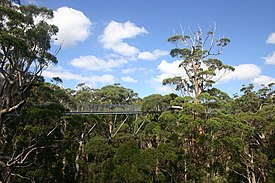
The Valley of the Giants skywalk at Walpole-Nornalup National Park
Western Australia is the second largest country subdivision in the world.
As of 2022, based on the latest Collaborative Australian Protected Areas Database report, it contains 1857 separate land-based protected areas with a total area of 76,142,710 hectares (188,152,700 acres), accounting for just over 30 percent of the state's land mass. By area, Indigenous Protected Areas account for the largest part of this, almost 67 percent while, by number, nature reserves hold the majority with two-third of all land-based protected areas being nature reserves. (Full article...) -
The country of Burundi in Africa has the following national parks and other protected areas. (Full article...)
-

Network of protected areas in Albania (2020)
Despite being a relatively small country, Albania is exceedingly rich in biodiversity. Its ecosystems and habitats support over 5,550 species of vascular and non-vascular plants and more than 15,600 species of coniferous and non-coniferous evergreens, most of which are threatened at global and European levels. The country has made recent efforts to expand its network of protected areas which now include: 11 national parks, 1 marine park, 718 nature monuments, 23 managed nature reserves, 11 protected landscapes, 4 World Heritage Sites, 4 Ramsar sites and other protected areas of various categories, that when combined, account for 21.36% of the territory. Furthermore, a biosphere reserve, 45 important plant areas and 16 important bird areas are found in the country.
Meanwhile, the central government has proclaimed the Coastline and the Tirana Greenbelt as areas of national importance. (Full article...)
.jpg)


.svg)
Selected world maps
-
 Mollweide projection of the world
 -
 The Goode homolosine projection is a pseudocylindrical, equal-area, composite map projection used for world maps.
 -
 Index map from the International Map of the World (1:1,000,000 scale)
 -
 Only a few of the largest large igneous provinces appear (coloured dark purple) on this geological map, which depicts crustal geologic provinces as seen in seismic refraction data
 -
 A plate tectonics map with volcano locations indicated with red circles
 -
 United Nations Human Development Index map by country (2016)
 -
 Time zones of the world
 -
 1516 map of the world by Martin Waldseemüller
 -
 The world map by Gerardus Mercator (1569), the first map in the well-known Mercator projection


World records
- List of Olympic records in athletics
- List of world records in athletics
- List of junior world records in athletics
- List of world records in masters athletics
- List of world youth bests in athletics
- List of IPC world records in athletics
- List of world records in canoeing
- List of world records in chess
- List of cycling records
- List of world records in track cycling
- List of world records in finswimming
- List of world records in juggling
- List of world records in rowing
- List of world records in speed skating
- List of world records in swimming
- List of IPC world records in swimming
- List of world records in Olympic weightlifting
Topics

Continents of Earth | ||||||||
|---|---|---|---|---|---|---|---|---|
| ||||||||
| ||||||||
| ||||||||


| Cenozoic Era (present–66.0 Ma) |
| ||||||||||||
|---|---|---|---|---|---|---|---|---|---|---|---|---|---|
| Mesozoic Era (66.0–252 Ma) |
| ||||||||||||
| Paleozoic Era (252–539 Ma) |
| ||||||||||||
| Proterozoic Eon (539 Ma–2.5 Ga) |
| ||||||||||||
| Archean Eon (2.5–4 Ga) | |||||||||||||
| Hadean Eon (4–4.6 Ga) | |||||||||||||
ka = kiloannum (thousands years ago); Ma = megaannum (millions years ago); Ga = gigaannum (billions years ago). See also: Geologic time scale • | |||||||||||||
| Locations | ||
|---|---|---|
| Related | ||

| |||||||||||||||||||
| |||||||||||||||||||
| |||||||||||||||||||

Economic classification of countries | |||||
|---|---|---|---|---|---|
| Three-World Model | |||||
| Gross domestic product (GDP) |
| ||||
| Gross national income (GNI) | |||||
| Wages | |||||
| Wealth | |||||
| Other national accounts | |||||
| Human development | |||||
| Digital divide | |||||
| Net international investment position (NIIP) | |||||
| Technological |
| ||||
|---|---|---|---|---|---|
| Sociological | |||||
| Ecological |
| ||||
| Biological |
| ||||
| Astronomical | |||||
| Eschatological |
| ||||
| Others |
| ||||
| Fictional | |||||
| Organizations | |||||
Categories

Wikimedia
The following Wikimedia Foundation sister projects provide more on this subject:
-
 Commons
Free media repository -
 Wikibooks
Free textbooks and manuals -
 Wikidata
Free knowledge base -
 Wikinews
Free-content news -
 Wikiquote
Collection of quotations -
 Wikisource
Free-content library -
 Wikispecies
Directory of species -
 Wikiversity
Free learning tools -
 Wikivoyage
Free travel guide -
 Wiktionary
Dictionary and thesaurus


