The Andes Portal

The Andes (/ˈændiːz/ AN-deez), Andes Mountains or Andean Mountain Range (Spanish: Cordillera de los Andes; Quechua: Anti) are the longest continental mountain range in the world, forming a continuous highland along the western edge of South America. The range is 8,900 km (5,530 mi) long and 200 to 700 km (124 to 435 mi) wide (widest between 18°S and 20°S latitude) and has an average height of about 4,000 m (13,123 ft). The Andes extend from South to North through seven South American countries.: Argentina, Chile, Bolivia, Peru, Ecuador, Colombia and western Venezuela.
Along their length, the Andes are split into several ranges, separated by intermediate depressions. The Andes are the location of several high plateaus—some of which host major cities such as Quito, Bogotá, Cali, Arequipa, Medellín, Bucaramanga, Sucre, Mérida, El Alto and La Paz. The Altiplano Plateau is the world's second-highest after the Tibetan Plateau. These ranges are in turn grouped into three major divisions based on climate: the Tropical Andes, the Dry Andes, and the Wet Andes.
The Andes Mountains are the highest mountain range outside Asia. The range’s highest peak, Argentina's Aconcagua, rises to an elevation of about 6,961 m (22,838 ft) above sea level. The peak of Chimborazo in the Ecuadorian Andes is farther from the Earth's center than any other location on the Earth's surface, due to the equatorial bulge resulting from the Earth's rotation. The world's highest volcanoes are in the Andes, including Ojos del Salado on the Chile-Argentina border, which rises to 6,893 m (22,615 ft). (Full article...)
Selected articles
-


Olca is a stratovolcano on the border of Chile and Bolivia. It lies in the middle of a 15 km long ridge composed of several stratovolcanos. Cerro Minchincha lies to the west and Paruma to the east. It is also close to the pre-Holocene Cerro Paruma. It is andesitic and dacitic in composition, with lava flows extending several kilometres north of the peak. The only activity from the ridge during historical times was a flank eruption from 1865 to 1867. The exact source of this eruption is unclear. (Full article...) -
Lastarria is a 5,697 metres (18,691 ft) high stratovolcano that lies on the border between Chile and Argentina. It is remote, and the surroundings are uninhabited but can be reached through an unpaved road. The volcano is part of the Central Volcanic Zone, one of the four segments of the volcanic arc of the Andes. Over a thousand volcanoes—of which about 50 are active—lie in this over 1,500 kilometres (930 mi) long chain of volcanoes, which is generated by subduction of the Nazca Plate beneath the South American Plate.
The volcano is constituted by two volcanic edifices that form a ridge, and one subsidiary lava flow field southwest of the main volcanoes. The main edifice features several aligned craters that form a line. There is no recorded eruptive activity, but the volcano displays vigorous fumarolic activity on its northern side and within the craters. It is located on top of older volcanic rocks and features both andesite and dacite. (Full article...) -
Lake Carhuacocha (possibly from Quechua qarwa leaf worm, larva of a beetle; pale, yellowish, golden, qucha lake,) is a lake in Peru located in the Huanuco Region, Lauricocha Province, on the border of the districts of Jesús and Queropalca. It lies on the east side of the Huayhuash mountain range. The lake is about 1.5 km long and 0.44 km at its widest point. (Full article...) -
Chinchillas are either of two species (Chinchilla chinchilla and Chinchilla lanigera) of crepuscular rodents of the parvorder Caviomorpha, and are native to the Andes mountains in South America. They live in colonies called "herds" at high elevations up to 4,270 m (14,000 ft). Historically, chinchillas lived in an area that included parts of Bolivia, Peru and Chile, but today, colonies in the wild are known only in Chile. Along with their relatives, viscachas, they make up the family Chinchillidae. They are also related to the chinchilla rat.
The chinchilla has the densest fur of all mammals that live on land, with around 20,000 hairs per square centimeter and 50 hairs growing from each follicle. In the water, the sea otter has a denser coat. The chinchilla is named after the Chincha people of the Andes, who once wore its dense, velvet-like fur. By the end of the 19th century, chinchillas had become quite rare after being hunted for their notably soft fur. Most chinchillas currently used by the fur industry for clothing and other accessories are farm-raised. Domestic chinchillas descended from C. lanigera are sometimes kept as pets, and may be considered a type of pocket pet. (Full article...) -

The Titicaca orestias, Lake Titicaca orestias, or Lake Titicaca flat-headed fish (Orestias cuvieri), also known by its native name amanto, is a likely extinct freshwater killifish from Lake Titicaca in South America. It belongs in the pupfish genus Orestias, endemic to lakes, rivers and streams in the Andean highlands. With a total length of up to 27 cm (10.6 in), it was the largest member in that genus. In the hope that an undiscovered population remains, it is listed as Data Deficient by the IUCN. Despite its common name, it is not the only Orestias from Lake Titicaca.
Its mouth was nearly turned upwards, thereby giving the flat head a concave shape. The head took up nearly a third of the whole body length. The upperside was greenish-yellow to umber. The lower jaw was black. Its scales were oddly light coloured at their centre. The scales of the young were blotched. (Full article...) -
Chumpe (possibly from Quechua chumpi: belt), Jatunriti, Ñanaloma or Yanaloma is a mountain in the Vilcanota mountain range in the Andes of Peru with 6,106 metres (20,033 ft) of elevation. It is located in the Cusco Region, Canchis Province, Pitumarca District as well as in the Quispicanchi Province, Ocongate District. Chumpe lies north of Lake Sibinacocha. (Full article...) -
Chimborazo (Spanish pronunciation: [tʃimboˈɾaso] ) is an inactive stratovolcano situated in the Cordillera Occidental range of the Andes. Its last known eruption is believed to have occurred around 550 A.D. Although not the tallest mountain in the Andes or on Earth relative to sea level, its summit is the farthest point on Earth's surface from the Earth's center, due to its location along the planet's equatorial bulge. Chimborazo's height is 6,263 m (20,548 ft), well below that of Mount Everest (8,849 m).
Chimborazo is the highest mountain in Ecuador and the 39th highest peak in the entire Andes. It is a popular destination for mountaineering due to its challenging climbing routes, which involve traversing snow, ice, and rocky terrain. (Full article...) -
Maipo is a stratovolcano in the Andes, lying on the border between Argentina and Chile. It is located 90 km (56 mi) south of Tupungato and about 100 km (62 mi) southeast of Santiago. It has a symmetrical, conical volcanic shape, and is among the southernmost 5,000 metre peaks in the Andes.
Maipo is located within the Diamante caldera, a feature measuring 15 km by 20 km that is about half a million years old. It rises about 1,900 m (6,230 ft) above the floor of the caldera. Immediately to the east of the peak, on the eastern side of the caldera floor, is Laguna del Diamante, a lake that formed when lava flows blocked drainage channels from the caldera in 1826. The Diamante Caldera erupted 450 cubic kilometers (108 cu mi) of tephra, 450 ka. (Full article...) -
Touching the Void is a 1988 book by Joe Simpson, recounting his and Simon Yates's near fatal descent after climbing the 6,344-metre (20,814 ft) peak Siula Grande in the Peruvian Andes. Approximately 15% of the book is written by Yates. It has sold over a million copies and has been translated into over 20 languages. (Full article...)
-
Cayambe or Volcán Cayambe is a volcano in Ecuador, in the Cordillera Central, a range of the Ecuadorian Andes. It is located in Pichincha Province, some 70 km (43 mi) northeast of Quito. It is the third-highest mountain in Ecuador, at an elevation of 5,790 m (18,996 ft) above sea level.
Cayambe, which has a permanent snow cap, is a Holocene compound volcano which last erupted in March 1786. At 4,690 metres (15,387 ft), its south slope is the highest point in the world crossed by the Equator, and the only point on the Equator with snow cover. The ice cap covers an area of about 22 km2 (8 sq mi) and there are glaciers on the eastern flank descending to about 4,400 m (14,400 ft), whereas those on the drier western flank reach about 4,700 m (15,400 ft). The volcano and most of its slopes are within the Cayambe Coca Ecological Reserve. (Full article...) -
Huandoy (probably from Quechua wantuy, to transfer, to transpose, to carry, to carry a heavy load) or Tullparaju (possibly from Quechua tullpa rustic cooking-fire, stove, rahu snow, ice, mountain with snow) is a mountain located inside Huascarán National Park in Ancash, Peru. It is the second-tallest peak of the Cordillera Blanca section of the Andes, after Huascarán. These two peaks are rather nearby, separated only by the Llanganuco glacial valley (which contains the Llanganuco Lakes) at 3,846 m asl.
It is a snow-capped mountain with four peaks arranged in the form of a fireplace, the tallest of which is 6,395 m. The four peaks are each over 6,000 m, and are:- Huandoy (6,395 m)
- Huandoy-West (6,356 m)
- Huandoy-South (6,160 m)
- Huandoy-East (6,000 m)
-
Patilla Pata is a stratovolcano in the Oruro Department in Bolivia. It is situated in the Sajama Province, in the west of the Curahuara de Carangas Municipality, at the border with Chile. Patilla Pata lies south-west of the mountain Jisk'a Kunturiri, north-east of the lake Q'asiri Quta (Khasiri Kkota) and the mountain Qullqi Warani, west of the little lake Sura Pata, south-east of the mountains Laram Q'awa, Kunturiri and Milluni and south of the little lake named Ch'iyar Quta.
The river Junt'uma K'uchu (Aymara junt'u warm, hot, uma water, k'uchu corner, "warm water corner", Junthuma Khuchu) originates south of Patilla Pata. It flows to the south-east as a right affluent of the Sajama River. (Full article...) -
Pico Humboldt is Venezuela's second highest peak, at 4,925 metres above sea level. It is located in the Sierra Nevada de Merida, in the Venezuelan Andes of (Mérida State). The peak, its sister peak Pico Bonpland, and the surrounding páramos are protected by the Sierra Nevada National Park. The mountain is named after German explorer and naturalist Alexander von Humboldt. (Full article...) -
Telmatobius is a genus of frogs native to the Andean highlands in South America, where they are found in Ecuador, Peru, Bolivia, northwestern Argentina and northern Chile. It is the only genus in the family Telmatobiidae. Some sources recognize Batrachophrynus as a valid genus distinct from Telmatobius. (Full article...) -
Siula Grande is a mountain in the Huayhuash mountain range in the Peruvian Andes. It is 6,344 metres (20,814 ft) high and has a subpeak, Siula Chico, 6,260 m (20,540 ft) high. (Full article...) -
Yerupajá is a mountain of the Huayhuash mountain range in west central Peru, part of the Andes. It is located at Áncash, Bolognesi Province, Lauricocha Province. At 6,635 metres (21,768 ft) (other sources: 6,617 m (21,709 ft)) it is the second-highest in Peru and the highest in the Huayhuash mountain range. The summit is the highest point in the Amazon River watershed, and was first reached in 1950 by Jim Maxwell and Dave Harrah, and its northern peak (Yerupajá Norte) in 1968 by the Wellingtonian Roger Bates and Graeme Dingle. Many visitors consider Yerupajá to be the most spectacular peak in South America.
There have been only a few successful ascents of the peak because it is one of the hardest Andean high peaks to climb. The most popular route is the southwest face. The approach is normally made from Huaraz southwards via Chiquián and Jahuacocha. (Full article...) -
Chacaltaya (Mollo language for "bridge of winds" or "winds meeting point", Aymara for "cold road"[dubious ]) is a mountain in the Cordillera Real, one of the mountain ranges of the Cordillera Oriental, itself a range of the Bolivian Andes. Its elevation is 5,421 meters (17,785 ft). Chacaltaya's glacier — which was as old as 18,000 years — had an area of 0.22 km2 (0.085 sq mi) in 1940, which had been reduced to 0.01 km2 (0.0039 sq mi) in 2007 and was completely gone by 2009. Half of the meltdown, as measured by volume, took place before 1980. The final meltdown after 1980, due to missing precipitation and the warm phase of El Niño, resulted in the glacier's disappearance in 2009. The glacier was located about 30 kilometers (19 mi) from La Paz, near Huayna Potosí mountain. (Full article...) -

The royal cinclodes (Cinclodes aricomae) is a Critically Endangered passerine bird in the Furnariinae subfamily of the ovenbird family Furnariidae. It is found in Bolivia and Peru. (Full article...) -
Illampu is the fourth highest mountain in Bolivia. It is located in the northern section of the Cordillera Real, part of the Andes, east of Lake Titicaca. It lies just north of the slightly higher Janq'u Uma, near the town of Sorata. Laguna Glaciar, located in the Illampu-Janq'u Uma massif, is the 17th highest lake in the world.
Despite being lower than Janq'u Uma, Illampu has a steeper peak, with more local relief, and is a somewhat harder climb. In fact it has "the hardest normal route on any of the 6,000 metre peaks in Bolivia." The easiest route, by the Southwest Ridge, is rated AD (Fairly Difficult), with snow slopes up to 65 degrees. It is accessed from a high camp on the north side of the massif. The peak was first climbed on June 7, 1928 via this route, by Hans Pfann, Alfred Horeschowsky, Hugo Hörtnagel (Germans) and Erwin Hein (Austrian). Other routes include the "German Route" on the southwest face and the South Face route, both approached from the west side of the massif. (Full article...) -
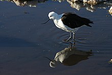
The Andean avocet (Recurvirostra andina) is a large wader in the avocet and stilt bird family, Recurvirostridae. It is resident in the Andes, breeding above 3500 m in northwestern Argentina, western Bolivia, northern Chile and southern Peru. (Full article...) -

Pico Mucuñuque is a mountain in the Andes of Venezuela. It has a height of 4,609 metres. (Full article...) -
Incahuasi (Spanish pronunciation: [iŋkaˈwasi]; possibly from Quechua: inka Inca, wasi house) is a volcanic mountain in the Andes of South America. It lies on the border of the Catamarca Province of Argentina and the Atacama Region of Chile. Incahuasi has a summit elevation of 6,621 metres (21,722 ft) above sea level.
The volcano consists of a 3.5-kilometre-wide (2.2 mi) caldera and two stratovolcanoes. Four pyroclastic cones located 7 kilometres (4.3 mi) to the northeast have produced basalt-andesite lava flows that cover an area of 10 square kilometres (4 sq mi). (Full article...) -
The vicuña (Lama vicugna) or vicuna (both /vɪˈkuːnjə/, very rarely spelled vicugna, its former genus name) is one of the two wild South American camelids, which live in the high alpine areas of the Andes, the other being the guanaco, which lives at lower elevations. Vicuñas are relatives of the llama, and are now believed to be the wild ancestor of domesticated alpacas, which are raised for their coats. Vicuñas produce small amounts of extremely fine wool, which is very expensive because the animal can only be shorn every three years and has to be caught from the wild. When knitted together, the product of the vicuña's wool is very soft and warm. The Inca valued vicuñas highly for their wool, and it was against the law for anyone but royalty to wear vicuña garments; today, the vicuña is the national animal of Peru and appears on the Peruvian coat of arms.
Both under the rule of the Inca and today, vicuñas have been protected by law, but they were heavily hunted in the intervening period. At the time they were declared endangered in 1974, only about 6,000 animals were left. Today, the vicuña population has recovered to about 350,000, and although conservation organizations have reduced its level of threat classification, they still call for active conservation programs to protect populations from poaching, habitat loss, and other threats. (Full article...) -
Monte Fitz Roy (also known as Cerro Chaltén, Cerro Fitz Roy, or simply Mount Fitz Roy) is a mountain in Patagonia, on the border between Argentina and Chile. It is located in the Southern Patagonian Ice Field, near El Chaltén village and Viedma Lake. It was first climbed in 1952 by French alpinists Lionel Terray and Guido Magnone. (Full article...) -
Rasac (possibly Quechua for toad) is a mountain in the Huayhuash mountain range in west central Peru, part of the Andes. It has a summit elevation of 6,017 metres (19,741 ft), although other sources cite a height of 6,040 metres (19,816 ft). Rasac is a long, relatively squat mountain on the western edge of the Huayhuash range, across the glacier from the tallest peak in the range, Yerupajá. Although it is a 6,000 metre mountain, Rasac's broad profile is dwarfed by Yerupajá. (Full article...)


-2.JPG)


.jpg)


.jpg)


Did you know...
- ... that the 1930s Polish Andean expeditions have been credited with several first ascents and the tracing of a new route to the summit of Aconcagua, the Andes' highest peak?
Need help?
Do you have a question about Andes that you can't find the answer to?
Consider asking it at the Wikipedia reference desk.
General images
-
 Map of a north-south sea-parallel pattern of rock ages in western Colombia. This pattern is a result of the Andean orogeny. (from Andean orogeny)
 -

-
 Laguna de Sonso tropical dry forest in Northern Andes (from Andes)
 -
 Parinacota, Bolivia/Chile (from Andes)
 -
 Topographic map of the Andes by the NASA. The southern and northern ends of the Andes are not shown. The Bolivian Orocline is visible as a bend in the coastline and the Andes lower half of the map. (from Andean orogeny)
 -
 Central Andes (from Andes)
 -
 Map of the Andean region of South America (from Andean agriculture)
 -
 Paleogeography of the Late Cretaceous South America. Areas subject to the Andean orogeny are shown in light grey while the stable cratons are shown as grey squares. The sedimentary formations of Los Alamitos and La Colonia that formed in the Late Cretaceous are indicated. (from Andean orogeny)
 -
 Frederic Edwin Church, Heart of the Andes, 1859. (from Andes)
 -

-

-
 Irrigating land in the Peruvian Andes (from Andes)
 -
 Simplified sketch of the present-situation along most of the Andes (from Andean orogeny)
 -
 Bolivian Andes (from Andes)
 -
 Pacha Mama Ceremony (from Andean agriculture)
 -

-

-

-
 Nevado del Huila, Colombia (from Andes)
 -

-

-
 Pico Humboldt at sunset (from Andes)
 -

-
 The seaward tilting of the sedimentary strata of Salto del Fraile Formation in Peru was caused by the Andean orogeny. (from Andean orogeny)
 -

-
 Mashua tubers (from Andean agriculture)
 -
 Syncline next to Nordenskjöld Lake in Torres del Paine National Park. The syncline formed during the Andean orogeny. (from Andean orogeny)
 -

-
 View of Cuernos del Paine in Torres del Paine National Park, Chile (from Andes)
 -
 A male Andean cock-of-the-rock, a species found in humid Andean forests and the national bird of Peru (from Andes)
 -
 Aerial view of Valle Carbajal in the Tierra del Fuego. The Andes range is about 200 km (124 mi) wide throughout its length, except in the Bolivian flexure where it is about 640 kilometres (398 mi) wide. (from Andes)
 -
 Peruvian farmers sowing maize and beans (from Andes)
 -
 Ulluco: Common crop of the Andean region (from Andean agriculture)

.jpg)


.jpg)


.jpg)


.JPG)


%E2%80%93Valle_Carbajal_01.jpg)

.jpg)
Subcategories

- Select [►] to view subcategories
Related portals
Subtopics
Associated Wikimedia
The following Wikimedia Foundation sister projects provide more on this subject:
-
 Commons
Free media repository -
 Wikibooks
Free textbooks and manuals -
 Wikidata
Free knowledge base -
 Wikinews
Free-content news -
 Wikiquote
Collection of quotations -
 Wikisource
Free-content library -
 Wikiversity
Free learning tools -
 Wiktionary
Dictionary and thesaurus


