ကြိုဆိုပါတယ်။ / Welcome to the Myanmar Portal 

Myanmar, officially the Republic of the Union of Myanmar and also known as Burma (the official name until 1989), is a country in Southeast Asia. It is the largest country by area in Mainland Southeast Asia and has a population of about 55 million. It is bordered by Bangladesh and India to its northwest, China to its northeast, Laos and Thailand to its east and southeast, and the Andaman Sea and the Bay of Bengal to its south and southwest. The country's capital city is Naypyidaw, and its largest city is Yangon (formerly Rangoon).
Myanmar is a member of the East Asia Summit, Non-Aligned Movement, ASEAN, and BIMSTEC, but it is not a member of the Commonwealth of Nations despite once being part of the British Empire. Myanmar is a Dialogue Partner of the Shanghai Cooperation Organization. The country is very rich in natural resources, such as jade, gems, oil, natural gas, teak and other minerals, as well as also endowed with renewable energy, having the highest solar power potential compared to other countries of the Great Mekong Subregion. However, Myanmar has long suffered from instability, factional violence, corruption, poor infrastructure, as well as a long history of colonial exploitation with little regard to human development. In 2013, its GDP (nominal) stood at US$56.7 billion and its GDP (PPP) at US$221.5 billion. The income gap in Myanmar is among the widest in the world, as a large proportion of the economy is controlled by cronies of the military junta. Myanmar is one of the least developed countries; as of 2020, according to the Human Development Index, it ranks 147 out of 189 countries in terms of human development, the lowest in Southeast Asia. Since 2021, more than 600,000 people were displaced across Myanmar due to the surge in violence post-coup, with more than 3 million people in dire need of humanitarian assistance. (Full article...)
Selected articles -
-
 Ashin Wirathu (Burmese: ဝီရသူ, Pali: Vīrasū; born 10 July 1968 in Kyaukse, Mandalay Division, Burma) is a Burmese Buddhist monk, and the leader of the 969 Movement in Myanmar. He has incited the persecution of Muslims in Myanmar through his speeches. Facebook banned his page on the charge of allegedly spreading religious hatred towards other communities, after repeated warnings to not post religiously inflammatory content. (Full article...)
 -
Hkakabo Razi (Burmese: ခါကာဘိုရာဇီ, pronounced [kʰàkàbò ɹàzì]; simplified Chinese: 开加博峰; traditional Chinese: 開加博峯; pinyin: Kāijiābó Fēng) is believed to be Myanmar's highest mountain. The 5,881-meter (19,295 ft)-tall mountain is the highest mountain in Southeast Asia as well. It is located in the northern Myanmar state of Kachin in an outlying subrange of the Greater Himalayan mountain system near the border tripoint with India and China. Its highest status has recently been challenged by 5,870-meter (19,260 ft)-tall Gamlang Razi, located about 6.6 kilometers (4.1 mi) WSW on the Chinese border.
The peak is enclosed within Khakaborazi National Park. The park is entirely mountainous and is characterized by broad-leaved evergreen tropical rain forest at low altitudes, a sub-tropical temperate zone from 8,000 to 9,000 ft (2,400–2,700 m), then broad-leaved, semi-deciduous forest and finally needle-leaved evergreen, snow forest. Above 11,000 ft (3,400 m), the highest forest zone is alpine, different from the forest not only in kind but in history and origin. Still higher, around 15,000 ft (4,600 m), cold, barren, windswept terrain and permanent snow and glaciers dominate. At around 17,500 ft (5,300 m), there is a large ice cap with several outlet glaciers. (Full article...) -
The Myanmar civil war, also called the Burmese Spring Revolution, Burmese civil war or People's Defensive War, is an ongoing civil war following Myanmar's long-running insurgencies, which escalated significantly in response to the 2021 military coup d'état and the subsequent violent crackdown on anti-coup protests. The exiled National Unity Government and major ethnic armed organisations repudiated the 2008 Constitution and called instead for a democratic federal state. Besides engaging this alliance, the SAC also contends with other anti-SAC forces in areas under its control. Hannah Beech of The New York Times observed the insurgents are apportioned into hundreds of armed groups scattered across the country.
As of March 2023, the United Nations (UN) estimated that since the coup in February 2021, 17.6 million people in Myanmar required humanitarian assistance, while 1.6 million were internally displaced, and over 55,000 civilian buildings had been destroyed. UNOCHA said that over 40,000 people had fled into neighboring countries, such as Bangladesh, India and Thailand. (Full article...) -
Extremely Severe Cyclonic Storm Nargis (Burmese: နာဂစ်; Urdu: نرگس, [ˈnərɡɪs]) was an extremely destructive and deadly tropical cyclone that caused the worst natural disaster in the recorded history of Myanmar during early May 2008. The cyclone made landfall in Myanmar on Friday, 2 May 2008, sending a storm surge 40 kilometres up the densely populated Irrawaddy delta, causing catastrophic destruction and at least 138,373 fatalities. The Labutta Township alone was reported to have 80,000 dead, with about 10,000 more deaths in Bogale. There were around 55,000 people missing and many other deaths were found in other towns and areas, although the Myanmar government's official death toll may have been under-reported, and there have been allegations that government officials stopped updating the death toll after 138,000 to minimise political fallout. The feared 'second wave' of fatalities from disease and lack of relief efforts never materialised. Damage was at $12 billion, making Nargis the costliest tropical cyclone on record in the North Indian Ocean at the time, before that record was broken by Cyclone Amphan in 2020.
The first named storm of the 2008 North Indian Ocean cyclone season, Nargis developed on 27 April in the central area of Bay of Bengal. Initially, the storm tracked slowly northwestward, and encountering favourable conditions, it quickly strengthened. Dry air weakened the cyclone on 29 April, though after beginning a steady eastward motion, Nargis rapidly intensified to attain peak winds of at least 165 km/h (105 mph) on 2 May, according to IMD observations; the JTWC assessed peak winds of 215 km/h (135 mph), making it a weak Category 4 cyclone on the SSHWS. The cyclone moved ashore in the Ayeyarwady Division of Myanmar at peak intensity and, after passing near the major city of Yangon (Rangoon), the storm gradually weakened until dissipating near the border of Myanmar and Thailand. (Full article...) -
The Bay of Bengal is the northeastern part of the Indian Ocean. The world's largest bay, geographically it is positioned between the Indian subcontinent and the Indochinese peninsula, located below the Bengal region / Current Bangladesh (based on which the bay was named during the British Raj).
Many South Asian and Southeast Asian countries are dependent on the Bay of Bengal. Geopolitically, the bay is bounded on the west and northwest by India, on the north by Bangladesh, and on the east by Myanmar and the Andaman and Nicobar Islands of India. Its southern limit is a line between Sangaman Kanda, Sri Lanka, and the northwesternmost point of Sumatra, Indonesia. Cox's Bazar, the longest sea beach in the world and Sundarbans, the largest mangrove forest and the natural habitat of the Bengal tiger, are located along the bay. (Full article...) -
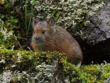
Forrest's pika (Ochotona forresti) is a species of mammal in the pika family, Ochotonidae. It is found in Bhutan, China, India, and Myanmar. The summer dorsal pelage and ventral pelage are dark rufous or blackish brown, and the winter dorsal pelage is a grayish brown, slightly lighter in tone than the ventral pelage. It is a generalist herbivore. It was assessed by the IUCN Red List of Endangered Species as insufficiently known in 1994, as near threatened in 1996, and re-assessed in 2008 as a species of least concern. (Full article...) -

General elections were held in Myanmar on 7 November 2010, in accordance with the new constitution, which was approved in a referendum held in May 2008. The election date was announced by the State Peace and Development Council (SPDC) on 13 August.
The elections were the fifth step of the seven-step "roadmap to democracy" proposed by the SPDC in 2003, the sixth and seventh steps being the convening of elected representatives and the building of a modern, democratic nation, respectively. However, the National League for Democracy boycotted the elections. The result was a sweeping victory for the Union Solidarity and Development Party, which won nearly 80% of seats contested across the upper and lower houses. The United Nations expressed concern about the fairness of the elections, and western countries dismissed them as fraudulent. (Full article...) -

Portrait of the Thirty Comrades
The Thirty Comrades (Burmese: ရဲဘော်သုံးကျိပ်) constituted the embryo of the modern Burmese army called the Burma Independence Army (BIA) which was formed to fight for independence from Britain. This was accomplished just before the majority of the Thirty Comrades returned with the invading Japanese Army initially through Southern Burma in December 1941.
In April 1941, small groups of Burmese youth left Burma secretly to obtain military training to fight the British colonists in the struggle for independence. Their leader was Thakin Aung San and they were sent by the Dobama Asiayone ("We Burmans Association") with the intention to get assistance from Guangzhou. By a quirk of fate, however, they ran into the Japanese instead in Amoy and arrived in Japan later to be flown to occupied parts of Sanya, in order to receive military training from the Japanese Army. They were later moved to Formosa for security reasons and subsequently returned to Burma via Vietnam and
Thailand with the Japanese. On 26 December 1941, in a house (owned by a Burmese doctor) in Bangkok, about 25 of the Thirty Comrades had their blood drawn from their arms in syringes, then poured into a silver bowl from which each of them drank – thway thauk in time-honoured Burmese military tradition – pledging "eternal loyalty" among themselves and to the cause of Burmese independence. Their average age was just 24 years. A Japanese officer called Suzuki Keiji, better known among the Burmese by his nom de guerre Bo Mogyo (Commander Thunderbolt) and head of a special intelligence unit called Minami Kikan (南機関) formed in order to support a national uprising in Burma, was the mentor and principal trainer of the Thirty Comrades. The British were driven out of Burma to India during World War II. (Full article...) -
The Karen (/kəˈrɛn/ kə-REN), also known as the Kayin, Kariang or Kawthoolese, are an ethnolinguistic group of Sino-Tibetan language-speaking peoples. The group as a whole is heterogeneous and disparate as many Karen ethnic groups do not associate or identify with each other culturally or linguistically. These Karen groups reside primarily in Kayin State, southern and southeastern Myanmar. The Karen account for around of the 6.69% Burmese population. Many Karen have migrated to Thailand, having settled mostly on the Myanmar–Thailand border. A few Karen have settled in the Andaman and Nicobar Islands, India, and other Southeast Asian and East Asian countries.
The Karen groups as a whole are often confused with the Padaung tribe, best known for the neck rings worn by their women, but they are just one sub-group of Red Karens (Karenni), one of the tribes of Kayah in Kayah State, Myanmar. (Full article...) -

Wing of the dragonfly Burmalindenia in a cabochon of Burmese amber, showing typical red colouration of the amber. Scale bar = 5mm
Burmese amber, also known as Burmite or Kachin amber, is amber from the Hukawng Valley in northern Myanmar. The amber is dated to around 100 million years ago, during the latest Albian to earliest Cenomanian ages of the mid-Cretaceous period. The amber is of significant palaeontological interest due to the diversity of flora and fauna contained as inclusions, particularly arthropods including insects and arachnids but also birds, lizards, snakes, frogs and fragmentary dinosaur remains. The amber has been known and commercially exploited since the first century AD, and has been known to science since the mid-nineteenth century. Research on the deposit has attracted controversy due to its alleged role in funding internal conflict in Myanmar and hazardous working conditions in the mines where it is collected. (Full article...)


Did you know (auto-generated) -

- ... that Rangoon kept its own time for more than two decades after Burma Standard Time first came into effect?
- ... that Maung O, Prince of Salin, and his sister Nanmadaw Me Nu became de facto rulers of Burma when King Bagyidaw was suffering from depression?
- ... that the Myanmar Coast Guard was initially proposed as a civilian law enforcement agency before being established as a branch of the military three years later?
- ... that the Burmese and South Korean first ladies held their first informal conversation 44 years after the establishment of bilateral relations between the two countries?
- ... that the mission of the United Nations special envoy on Myanmar has been called a "diplomatic graveyard"?
- ... that Esther Ze Naw, who appeared on the 2021 Time 100, was one of the few people in Myanmar who protested against Aung San Suu Kyi's defence of the military at the International Court of Justice in December 2019?
- ... that Maw Htun Aung, a Shan Nationalities League for Democracy candidate in the 2020 Myanmar general election, is Kachin, not Shan?
- ... that Thinzar Shunlei Yi hid in the Burmese jungle for a month and joined a rebel militia following the 2021 Myanmar coup d'état?
Related portals and projects
General images -
-
 Aerial view of a burned Rohingya village in Rakhine state, Myanmar, September 2017 (from History of Myanmar)
 -
 A wide range of Burmese lacquerware from Bagan (from Culture of Myanmar)
 -
 The restored Taungoo or Nyaungyan dynasty c. 1650 CE. (from History of Myanmar)
 -
 Temples at Mrauk U, was the capital of the Mrauk U Kingdom, which ruled over what is now Rakhine State. (from History of Myanmar)
 -
 A theatrical performance of the Mon dance (from Culture of Myanmar)
 -
 A group of Buddhist worshipers at Shwedagon Pagoda, an important religious site for Burmese Buddhists (from Culture of Myanmar)
 -
 Boxing match, 19th-century watercolour (from Culture of Myanmar)
 -
 Political Map of Burma (Myanmar) c. 1450 CE. (from History of Myanmar)
 -
 19th-century funeral cart and spire, which would form part of the procession from the home to the place of cremation (from Culture of Myanmar)
 -
 Protesters in Yangon carrying signs reading "Free Daw Aung San Suu Kyi" on 8 February 2021. (from History of Myanmar)
 -
 Hlei pyaingbwè - a Burmese regatta (from Culture of Myanmar)
 -
 British soldiers on patrol in the ruins of the Burmese town of Bahe during the advance on Mandalay, January 1945. (from History of Myanmar)
 -
 Mountains near Pindaya on the Shan Plateau (from Geography of Myanmar)
 -
 A bull fight, 19th-century watercolour (from Culture of Myanmar)
 -
 Myinhkin thabin - equestrian sport (from Culture of Myanmar)
 -
 Portuguese ruler and soldiers mounting an Elephant. Philips, Jan Caspar (draughtsman and engraver) (from History of Myanmar)
 -
 Jade Mine in Hpakant (from Geography of Myanmar)
 -
 Two female musicians play the saung at a performance in Mandalay. (from Culture of Myanmar)
 -
 The paddle steamer Ramapoora (right) of the British India Steam Navigation Company on the Rangoon river having just arrived from Moulmein. 1895. Photographers: Watts and Skeen (from History of Myanmar)
 -
 A large fracture on the Mingun Pahtodawgyi caused by the 1839 Ava earthquake. (from Geography of Myanmar)
 -

-

-
 Former US President Barack Obama poses barefoot on the grounds of Shwedagon Pagoda, one of Myanmar's major Buddhist pilgrimage sites. (from Culture of Myanmar)
 -
 Aung San Suu Kyi addresses crowds at the NLD headquarters shortly after her release. (from History of Myanmar)
 -
 British soldiers dismantling cannons belonging to King Thibaw's forces, Third Anglo-Burmese War, Ava, 27 November 1885. Photographer: Hooper, Willoughby Wallace (1837–1912). (from History of Myanmar)
 -
 Salween river at Mae Sam Laep on the Thai-Myanmar border (from Geography of Myanmar)
 -
 Recorder's Court on Sule Pagoda Road, with the Sule Pagoda at the far end, Rangoon, 1868. Photographer: J. Jackson. (from History of Myanmar)
 -
 A wedding procession, with the groom and bride dressed in traditional Burmese wedding clothes, reminiscent of royal attire (from Culture of Myanmar)
 -
 Sculpture of Myanmar mythical lion (from Culture of Myanmar)
 -
 Saint Mary's Cathedral in Downtown Yangon is the largest Roman Catholic cathedral in Burma. (from Culture of Myanmar)
 -
 Vegetable stall on the roadside at the Madras Lancer Lines, Mandalay, January 1886. Photographer: Hooper, Willoughby Wallace (1837–1912). (from History of Myanmar)
 -
 Myanmar (Burma) map of Köppen climate classification (from Geography of Myanmar)
 -
 Grandfather Island, Dawei (from Geography of Myanmar)
 -
 Protesters in Yangon with a banner that reads non-violence: national movement in Burmese, in the background is Shwedagon Pagoda. (from History of Myanmar)
 -

-

-
 British soldiers remove their shoes at the entrance of Shwedagon Pagoda. To the left, a sign reads "Foot wearing is strictly prohibited" in Burmese, English, Tamil, and Urdu. (from Culture of Myanmar)
 -
 The shores of Irrawaddy River at Nyaung-U, Bagan (from Geography of Myanmar)
 -
 Pagan Kingdom during Narapatisithu's reign. Burmese chronicles also claim Kengtung and Chiang Mai. Core areas shown in darker yellow. Peripheral areas in light yellow. Pagan incorporated key ports of Lower Burma into its core administration by the 13th century. (from History of Myanmar)
 -
 Mount Popa, a dormant volcano in the Central Lowlands (from Geography of Myanmar)


_headquarter.jpg)


Major topics
Categories

More topics

Associated Wikimedia
The following Wikimedia Foundation sister projects provide more on this subject:
-
 Commons
Free media repository -
 Wikibooks
Free textbooks and manuals -
 Wikidata
Free knowledge base -
 Wikinews
Free-content news -
 Wikiquote
Collection of quotations -
 Wikisource
Free-content library -
 Wikiversity
Free learning tools -
 Wikivoyage
Free travel guide -
 Wiktionary
Dictionary and thesaurus


