Mecia de Viladestes, also known as Mecià or Macià de Viladestes was a 15th Century Jewish cartographer, one of the Mallorcan school of cartography.[1] The name Mecia is a variant of Matias or Matthew. His birth name was Samuel Corchos.[2] In 1401, he was conveyed to Sicily under license from the governor of Mallorca, presumably one of the jews forcibly converted to Christianity around this time.[3][4]

He is mostly known for his 1413 portolan chart which shows the N.E Atlantic Ocean, the Mediterranean Sea, the Black Sea, the Red Sea, and parts of the Caspian Sea, the Persian Gulf and the Baltic Sea. The map, which measures 1.21 X 0.87m, was discovered by Joaquín Lorenzo Villanueva in the archives of the Carthusian monastery of the Val de Cristo, near the town of Segorbe in Spain. It bears the inscription in gold letters MECIA DE VILA DESTIS ME FECIT IN ANO MCCCCCXIII - Mecia de Viladestes made me in the year 1413.[5][3] A complete reproduction of the map was first published in 1896.[6] The map is now in the National Library of France.[7]
The map is notable as one of the first to show detail of Africa south of the Atlas mountains. This includes factual material, such as Mali with Timbuktu and an image of its 14th Century King Mussa Melli; as well as conjectural material, such as Prester John, shown in Ethiopia.[2] The north Atlantic shows a whaling ship, and Great Britain is shown without the distortion or "turning" of Scotland that is found in later maps, after Ptolemy's Geography became available in latin translation.[8] The border between England and Scotland is very stylized, with mountains and two castles (probably Carlisle and Edinburgh) shown at right angles to the border, and rivers running east and west from the mountains. This convention may have led to later portolan charts showing England and Scotland as separate islands.[9][10]
-
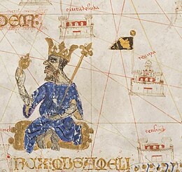 Mussa Melli and Timbuktu
 -
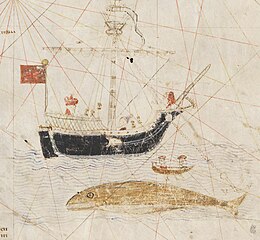 Whaling in the north Atlantic
 -
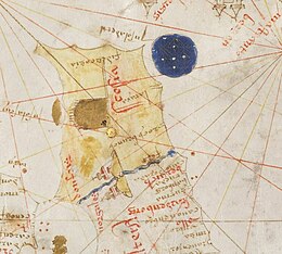 Scotland and northern England


References edit
- ^ Entralgo, Pedro Laín; Piñero, José M.López (1960). "The Spanish contribution to world science". Cahiers d'Histoire Mondiale. 6 (1): 948–968. ISSN 0022-5436.
- ^ a b Brunnlechner, Gerda (2018). "In Search of Prester John and the 'River of Gold'. Mecià de Viladestes' Map and Late Medieval Knowledge about Africa". Journal of Transcultural Medieval Studies. 5 (2): 261–294. doi:10.1515/JTMS-2018-0021.
- ^ a b Hamy, Ernest Théodore (1902). "Mecia de Viladestes: cartographe juif majorcain du commencement du XVe siècle". Comptes rendus des séances de l'Académie des Inscriptions et Belles-Lettre (in French). 46th Year (1): 71–75.
- ^ The Jewish encyclopedia : a descriptive record of the history, religion, literature, and customs of the Jewish people from the earliest times to the present day. Volume 8. New York: Funk and Wagnalls. 1901. p. 398.
- ^ Villanueva, Joaquin Lorenzo (1806). Viage literario a las iglesias de España Volume 4. Madrid: En la Imprenta Real. p. 25.
- ^ Marcel, Gabriel. "Choix de Cartes et de Mappemondes des XIVe et XVe siecles". Biblioteca Virtual de Defensa. Portal Patrimonio Cultural de DefMinisterio de Defensa de España. Retrieved 25 November 2023.
- ^ Mecia de Viladestes. "Carte marine de l'océan Atlantique Nord-Est, de la mer Méditerranée, de la mer Noire, de la mer Rouge, d'une partie de la mer Caspienne, du golfe Persique et de la mer Baltique". BnF Gallica. Retrieved 25 November 2023.
- ^ Jones, Barri; Keillar, Ian (1996). "Marinus, Ptolemy and the turning of Scotland". Britannia. 27: 43–49. doi:10.2307/527039.
- ^ Andrews, Michael C. (1927). "The boundary between Scotland and England in the portolan charts". Proceedings of the Society of Antiquaries of Scotland. 80: 36–66.
- ^ Steinberg, Philip E. (2005). "Insularity, sovereignty and statehood: The representation of islands on portolan charts and the construction of the territorial state". Geografiska Annaler: Series B, Human Geography. 87 (4): 253–265.
Category:History of geography
Category:Maps
Category:Forced religious conversion
Category:Nautical charts
56°40′4″N 4°5′52″W / 56.66778°N 4.09778°W
The Schiehallion experiment was an 18th-century experiment to determine the mean density of the Earth. Funded by a grant from the Royal Society, it was conducted in the summer of 1774 around the Scottish mountain of Schiehallion, Perthshire. The experiment involved measuring the tiny deflection of the vertical due to the gravitational attraction of a nearby mountain. Schiehallion was considered the ideal location after a search for candidate mountains, thanks to its isolation and almost symmetrical shape.

The experiment had previously been considered, but rejected, by Isaac Newton as a practical demonstration of his theory of gravitation; however, a team of scientists, notably Nevil Maskelyne, the Astronomer Royal, was convinced that the effect would be detectable and undertook to conduct the experiment. The deflection angle depended on the relative densities and volumes of the Earth and the mountain: if the density and volume of Schiehallion could be ascertained, then so could the density of the Earth. Once this was known, it would in turn yield approximate values for those of the other planets, their moons, and the Sun, previously known only in terms of their relative ratios.
Background edit
A pendulum hangs straight downwards in a symmetrical gravitational field. However, if a sufficiently large mass such as a mountain is nearby, its gravitational attraction should pull the pendulum's plumb-bob slightly out of true (in the sense that it doesn't point to the centre of mass of the Earth). The change in plumb-line angle against a known object—such as a star—could be carefully measured on opposite sides of the mountain. If the mass of the mountain could be independently established from a determination of its volume and an estimate of the mean density of its rocks, then these values could be extrapolated to provide the mean density of the Earth, and by extension, its mass.
Isaac Newton had considered the effect in the Principia,[1] but pessimistically thought that any real mountain would produce too small a deflection to measure.[2] Gravitational effects, he wrote, were only discernible on the planetary scale.[2] Newton's pessimism was unfounded: although his calculations had suggested a deviation of less than 2 minutes of arc (for an idealised three-mile high [5 km] mountain), this angle, though very slight, was within the theoretical capability of instruments of his day.[3]
An experiment to test Newton's idea would both provide supporting evidence for his law of universal gravitation, and estimates of the mass and density of the Earth. Since the masses of astronomical objects were known only in terms of relative ratios, the mass of the Earth would provide reasonable values to the other planets, their moons, and the Sun. The data were also capable of determining the value of the Newtonian constant of gravitation G, though this was not a goal of the experimenters; references to a value for G would not appear in the scientific literature until almost a hundred years later.[4]
Finding the mountain edit

Chimborazo, 1738 edit
A pair of French astronomers, Pierre Bouguer and Charles Marie de La Condamine, were the first to attempt the experiment, conducting their measurements on the 6,268-metre (20,564 ft) volcano Chimborazo. At the time, this lay in the "Real Audiencia of Quito" of the Viceroyalty of Peru,[5] and is now in the province of Chimborazo in the Republic of Ecuador. Their expedition had left France for South America in 1735 to try to measure the meridian arc length of one degree of latitude near the equator, but they took advantage of the opportunity to attempt the deflection experiment. In December 1738, under very difficult conditions of terrain and climate, they conducted a pair of measurements at altitudes of 4,680 and 4,340 m.[6] Bouguer wrote in a 1749 paper that they had been able to detect a deflection of 8 seconds of arc, but he downplayed the significance of their results, suggesting that the experiment would be better carried out under easier conditions in France or England.[3][6] He added that the experiment had at least proved that the Earth could not be a hollow shell, as some thinkers of the day, including Edmond Halley, had suggested.[5]
Schiehallion, 1774 edit

Between 1763 and 1767, during operations to survey the Mason–Dixon line between the states of Pennsylvania and Maryland, British astronomers found many more systematic and non-random errors than might have been expected, extending the work longer than planned.[7] When this information reached the members of the Royal Society, Henry Cavendish realized that the phenomenon may have been due to the gravitational pull of the nearby Allegheny Mountains, which had probably diverted the plumb lines of the theodolites and the liquids inside spirit levels.[8]
Prompted by this news, a further attempt on the experiment was proposed to the Royal Society in 1772 by Nevil Maskelyne, Astronomer Royal.[9] He suggested that the experiment would "do honour to the nation where it was made"[3] and proposed Whernside in Yorkshire, or the Blencathra-Skiddaw massif in Cumberland as suitable targets. The Royal Society formed the Committee of Attraction to consider the matter, appointing Maskelyne, Joseph Banks and Benjamin Franklin amongst its members.[10] The Committee dispatched the astronomer and surveyor Charles Mason to find a suitable mountain.[1]
After a lengthy search over the summer of 1773, Mason reported that the best candidate was Schiehallion (then spelled Schehallien), a 1,083 m (3,553 ft) peak lying between Loch Tay and Loch Rannoch in the central Scottish Highlands.[10] The mountain stood in isolation from any nearby hills, which would reduce their gravitational influence, and its symmetrical east–west ridge would simplify the calculations. Its steep northern and southern slopes would allow the experiment to be sited close to its centre of mass, maximising the deflection effect.
Mason declined to conduct the work himself for the offered commission of one guinea per day.[10] The task therefore fell to Maskelyne, for which he was granted a temporary leave of his duties as Astronomer Royal. He was aided in the task by mathematician and surveyor Charles Hutton, and Reuben Burrow who was a mathematician of the Royal Greenwich Observatory. A workforce of labourers was engaged to construct observatories for the astronomers and assist in the surveying. The science team was particularly well-equipped: its astronomical instruments included a 12 in (30 cm) brass quadrant from Cook's 1769 transit of Venus expedition, a 10 ft (3.0 m) zenith sector, and a regulator (precision pendulum clock) for timing the astronomical observations.[11] They also acquired a theodolite and Gunter's chain for surveying the mountain, and a pair of barometers for measuring altitude.[11] Generous funding for the experiment was available due to underspend on the transit of Venus expedition, which had been turned over to the Society by King George III.[1][3]
Measurements edit
Astronomical edit

Observatories were constructed to the north and south of the mountain, plus a bothy to accommodate equipment and the scientists.[6] The ruins of these structures remain on the mountainside. Most of the workforce was housed in rough canvas tents. Maskelyne's astronomical measurements were the first to be conducted. It was necessary for him to determine the zenith distances with respect to the plumb line for a set of stars at the precise time that each passed due south (astronomic latitude).[3][12][13] Weather conditions were frequently unfavourable due to mist and rain. However, from the south observatory, he was able to take 76 measurements on 34 stars in one direction, and then 93 observations on 39 stars in the other. From the north side, he then conducted a set of 68 observations on 32 stars and a set of 100 on 37 stars.[6] By conducting sets of measurements with the plane of the zenith sector first facing east and then west, he successfully avoided any systematic errors arising from collimating the sector.[1]
To determine the deflection due to the mountain, it was necessary to account for the curvature of the Earth: an observer moving north or south will see the local zenith shift by the same angle as any change in geodetic latitude. After accounting for observational effects such as precession, aberration of light and nutation, Maskelyne showed that the difference between the locally determined zenith for observers north and south of Schiehallion was 54.6 arc seconds.[6] Once the surveying team had provided a difference of 42.94″ latitude between the two stations, he was able to subtract this, and after rounding to the accuracy of his observations, announce that the sum of the north and south deflections was 11.6″.[3][6][14]
Maskelyne published his initial results in the Philosophical Transactions of the Royal Society in 1775,[14] using preliminary data on the mountain's shape and hence the position of its center of gravity. This led him to expect a deflection of 20.9″ if the mean densities of Schiehallion and the Earth were equal.[3][15] Since the deflection was about half this, he was able to make a preliminary announcement that the mean density of the Earth was approximately double that of Schiehallion. A more accurate value would have to await completion of the surveying process.[14]
Maskelyne took the opportunity to note that Schiehallion exhibited a gravitational attraction, and thus all mountains did; and that Newton's inverse square law of gravitation had been confirmed.[14][16] An appreciative Royal Society presented Maskelyne with the 1775 Copley Medal; the biographer Chalmers later noting that "If any doubts yet remained with respect to the truth of the Newtonian system, they were now totally removed".[17]
Surveying edit
The work of the surveying team was greatly hampered by the inclemency of the weather, and it took until 1776 to complete the task.[15][a] To find the volume of the mountain, it was necessary to divide it into a set of vertical prisms and compute the volume of each. The triangulation task falling to Charles Hutton was considerable: the surveyors had obtained thousands of bearing angles to more than a thousand points around the mountain.[18] Moreover, the vertices of his prisms did not always conveniently coincide with the surveyed heights. To make sense of all his data, he hit upon the idea of interpolating a series of lines at set intervals between his measured values, marking points of equal height. In doing so, not only could he easily determine the heights of his prisms, but from the swirl of the lines one could get an instant impression of the form of the terrain. Hutton thus used contour lines, which became in common use since for depicting cartographic relief.[6][18]
| Body | Density, kg·m−3 | |
|---|---|---|
| Hutton, 1778[19][b] | Modern value[20] | |
| Sun | 1,100 | 1,408 |
| Mercury | 9,200 | 5,427 |
| Venus | 5,800 | 5,204 |
| Earth | 4,500 | 5,515 |
| Moon | 3,100 | 3,340 |
| Mars | 3,300 | 3,934 |
| Jupiter | 1,100 | 1,326 |
| Saturn | 410 | 687 |
Hutton had to compute the individual attractions due to each of the many prisms that formed his grid, a process which was as laborious as the survey itself. The task occupied his time for a further two years before he could present his results, which he did in a hundred-page paper to the Royal Society in 1778.[19] He found that the attraction of the plumb-bob to the Earth would be 9,933 times that of the sum of its attractions to the mountain at the north and south stations, if the density of the Earth and Schiehallion had been the same.[18] Since the actual deflection of 11.6″ implied a ratio of 17,804:1 after accounting for the effect of latitude on gravity, he was able to state that the Earth had a mean density of , or about that of the mountain.[15][18][19] The lengthy process of surveying the mountain had not therefore greatly affected the outcome of Maskelyne's calculations. Hutton took a density of 2,500 kg·m−3 for Schiehallion, and announced that the density of the Earth was of this, or 4,500 kg·m−3.[18] In comparison with the modern accepted figure of 5,515 kg·m−3,[20] the density of the Earth had been computed with an error of less than 20%.


That the mean density of the Earth should so greatly exceed that of its surface rocks naturally meant that there must be more dense material lying deeper. Hutton correctly surmised that the core material was likely metallic, and might have a density of 10,000 kg·m−3.[18] He estimated this metallic portion to occupy some 65% of the diameter of the Earth.[19] With a value for the mean density of the Earth, Hutton was able to set some values to Jérôme Lalande's planetary tables, which had previously only been able to express the densities of the major solar system objects in relative terms.[19]
Repeat experiments edit
A more accurate measurement of the mean density of the Earth was made 24 years after Schiehallion, when in 1798 Henry Cavendish used an exquisitely sensitive torsion balance to measure the attraction between large masses of lead. Cavendish's figure of 5,448 ± 33 kg·m−3 was only 1.2% from the currently accepted value of 5,515 kg·m−3, and his result would not be significantly improved upon until 1895 by Charles Boys.[c] The care with which Cavendish conducted the experiment and the accuracy of his result has led his name to since be associated with it.[21]
The Scottish scientist John Playfair carried out a second survey of Schiehallion in 1811; on the basis of a rethink of its rock strata, he suggested a density of 4,560 to 4,870 kg·m−3,[22] though the then elderly Hutton vigorously defended the original value in an 1821 paper to the Society.[3][23] Playfair's calculations had raised the density closer towards its modern value, but was still too low and significantly poorer than Cavendish's computation of some years earlier.

The Schiehallion experiment was repeated in 1856 by Henry James, director-general of the Ordnance Survey, who instead used the hill Arthur's Seat in central Edinburgh.[6][13][24] With the resources of the Ordnance Survey at his disposal, James extended his topographical survey to a 21-kilometre radius, taking him as far as the borders of Midlothian. He obtained a density of about 5,300 kg·m−3.[3][15]
An experiment in 2005 undertook a variation of the 1774 work: instead of computing local differences in the zenith, the experiment made a very accurate comparison of the period of a pendulum at the top and bottom of Schiehallion. The period of a pendulum is a function of g, the local gravitational acceleration. The pendulum is expected to run more slowly at altitude, but the mass of the mountain will act to reduce this difference. This experiment has the advantage of being considerably easier to conduct than the 1774 one, but to achieve the desired accuracy, it is necessary to measure the period of the pendulum to within one part in one million.[12] This experiment yielded a value of the mass of the Earth of 8.1 ± 2.4 × 1024 kg,[25] corresponding to a mean density of 7,500 ± 1,900 kg·m−3.[d][better source needed]
A modern re-examination of the geophysical data was able to take account of factors the 1774 team could not. With the benefit of a 120-km radius digital elevation model, greatly improved knowledge of the geology of Schiehallion, and the help of a computer, a 2007 report produced a mean Earth density of 5,480 ± 250 kg·m−3.[26] When compared to the modern figure of 5,515 kg·m−3, it stood as a testament to the accuracy of Maskelyne's astronomical observations.[26]
Mathematical procedure edit

Consider the force diagram to the right, in which the deflection has been greatly exaggerated. The analysis has been simplified by considering the attraction on only one side of the mountain.[22] A plumb-bob of mass m is situated a distance d from P, the centre of mass of a mountain of mass MM and density ρM. It is deflected through a small angle θ due to its attraction F towards P and its weight W directed towards the Earth. The vector sum of W and F results in a tension T in the pendulum string. The Earth has a mass ME, radius rE and a density ρE.
The two gravitational forces on the plumb-bob are given by Newton's law of gravitation:

where G is the Newtonian constant of gravitation. G and m can be eliminated by taking the ratio of F to W:

where VM and VE are the volumes of the mountain and the Earth. Under static equilibrium, the horizontal and vertical components of the string tension T can be related to the gravitational forces and the deflection angle θ:

Substituting for T:

Since VE, VM and rE are all known, θ has been measured and d has been computed, then a value for the ratio ρE : ρM can be obtained:[22]

Notes edit
- ^ During a drunken party to celebrate the end of the surveying, the northern observatory was accidentally burned to the ground, taking with it a fiddle belonging to Duncan Robertson, a junior member of the surveying team. In gratitude for the entertainment Robertson's playing had provided Maskelyne during the four months of astronomical observations, he compensated him by replacing the lost violin with one that is now called The Yellow London Lady.
- ^ Hutton's values are expressed as common fractions as a multiple of the density of water, e.g. Mars . They have been expressed here as two significant-digit integers, multiplied by a water density of 1000 kg·m−3
- ^ A value of 5,480 kg·m−3 appears in Cavendish's paper. He had however made an arithmetical error: his measurements actually led to a value of 5,448 kg·m−3; a discrepancy that was not found until 1821 by Francis Baily.
- ^ Taking the volume of the Earth to be 1.0832 × 10¹² km3.

References edit
- ^ a b c d Davies, R.D. (1985). "A Commemoration of Maskelyne at Schiehallion". Quarterly Journal of the Royal Astronomical Society. 26 (3): 289–294. Bibcode:1985QJRAS..26..289D.
- ^ a b Newton (1972). Philosophiæ Naturalis Principia Mathematica. Vol. II. p. 528. ISBN 0-521-07647-1. Archived from the original on 16 August 2022. Retrieved 28 December 2008. Translated: Andrew Motte, First American Edition. New York, 1846
- ^ a b c d e f g h i Sillitto, R.M. (31 October 1990). "Maskelyne on Schiehallion: A Lecture to The Royal Philosophical Society of Glasgow". Retrieved 28 December 2008.
- ^ Cornu, A.; Baille, J. B. (1873). "Mutual determination of the constant of attraction and the mean density of the earth". Comptes rendus de l'Académie des sciences. 76: 954–958.
- ^ a b Poynting, J.H. (1913). The Earth: its shape, size, weight and spin. Cambridge. pp. 50–56.
- ^ a b c d e f g h Poynting, J. H. (1894). The mean density of the earth (PDF). pp. 12–22.
- ^ Mentzer, Robert (August 2003). "How Mason & Dixon Ran Their Line" (PDF). Professional Surveyor Magazine. Archived from the original (PDF) on 7 January 2014. Retrieved 3 August 2021.
- ^ Tretkoff, Ernie. "This Month in Physics History June 1798: Cavendish weighs the world". American Physical Society. Retrieved 3 August 2021.
- ^ Maskelyne, N. (1772). "A proposal for measuring the attraction of some hill in this Kingdom". Philosophical Transactions of the Royal Society. 65: 495–499. Bibcode:1775RSPT...65..495M. doi:10.1098/rstl.1775.0049.
- ^ a b c Danson, Edwin (2006). Weighing the World. Oxford University Press. pp. 115–116. ISBN 978-0-19-518169-2.
- ^ a b Danson, Edwin (2006). Weighing the World. Oxford University Press. p. 146. ISBN 978-0-19-518169-2.
- ^ a b "The "Weigh the World" Challenge 2005" (PDF). countingthoughts. 23 April 2005. Retrieved 28 December 2008.
- ^ a b Poynting, J.H. (1913). The Earth: its shape, size, weight and spin. Cambridge. pp. 56–59.
- ^ a b c d Maskelyne, N. (1775). "An Account of Observations Made on the Mountain Schiehallion for Finding Its Attraction". Philosophical Transactions of the Royal Society. 65: 500–542. doi:10.1098/rstl.1775.0050.
- ^ a b c d Poynting, J. H.; Thomson, J. J. (1909). A text-book of physics (PDF). pp. 33–35. ISBN 1-4067-7316-6.
- ^ Mackenzie, A.S. (1900). The laws of gravitation; memoirs by Newton, Bouguer and Cavendish, together with abstracts of other important memoirs (PDF). pp. 53–56.
- ^ Chalmers, A. (1816). The General Biographical Dictionary. Vol. 25. p. 317.
- ^ a b c d e f Danson, Edwin (2006). Weighing the World. Oxford University Press. pp. 153–154. ISBN 978-0-19-518169-2.
- ^ a b c d e Hutton, C. (1778). "An Account of the Calculations Made from the Survey and Measures Taken at Schehallien". Philosophical Transactions of the Royal Society. 68. doi:10.1098/rstl.1778.0034.
- ^ a b "Planetary Fact Sheet". Lunar and Planetary Science. NASA. Retrieved 2 January 2009.
- ^ Jungnickel, Christa; McCormmach, Russell (1996). Cavendish. American Philosophical Society. pp. 340–341. ISBN 978-0-87169-220-7.
- ^ a b c Ranalli, G. (1984). "An Early Geophysical Estimate of the Mean Density of the Earth: Schehallien, 1774". Earth Sciences History. 3 (2): 149–152. doi:10.17704/eshi.3.2.k43q522gtt440172.
- ^ Hutton, Charles (1821). "On the mean density of the earth". Proceedings of the Royal Society.
- ^ James (1856). "On the Deflection of the Plumb-Line at Arthur's Seat, and the Mean Specific Gravity of the Earth". Proceedings of the Royal Society. 146: 591–606. doi:10.1098/rstl.1856.0029. JSTOR 108603.
- ^ "The "Weigh the World" Challenge Results". countingthoughts. Archived from the original on 3 March 2016. Retrieved 28 December 2008.
- ^ a b Smallwood, J.R. (2007). "Maskelyne's 1774 Schiehallion experiment revisited". Scottish Journal of Geology. 43 (1): 15–31. doi:10.1144/sjg43010015. S2CID 128706820.
Template:Good article is only for Wikipedia:Good articles.
Category:Physics experiments
Category:Density
Category:Geodesy
Category:Geodetic surveys
Category:Gravity
Category:History of Earth science
Category:History of physics
Category:Structure of the Earth
Category:History of Perth and Kinross
Category:Mountains and hills of Perth and Kinross
Category:Science and technology in Scotland
Category:1774 in science
Category:1774 in Scotland
Category:18th century in Scotland
Category:Royal Society
Washington's term as Hydrographer began in wartime, and the first priority, already underway while he was Beaufort's assistant, was the supply of charts, particularly to the French Navy. 70,000 more charts had been issued in 1854 than in 1852. The Second China War and the prospect of war with Japan led to shipments of charts of Asia. (Ref Dy p67) After the war with Russia was over, Washington turned his attention to the production and sale of charts. Beaufort had insisted on personally inspecting every chart before it was published, and this had led to delays and a backlog of unpublished charts. Washington accepted the need for careful review, but delegated this work to naval assistants, initially to Captain A.B. Becher, then increasingly to more junior assistants. Chart production and distribution were also re-organised, printing being outsourced to Messrs. Malby and Sons, and the sale of charts by agents and the updating and correction of stock regularised. In the 1864 catalogue, 2,500 charts were listed, a 20% increase since 1855. Sales revenue also increased. Surveying activity was also increased, with more surveys ongoing than at any time before or since. A new initiative during this period was deep-sea sounding in preparation for the laying of long-distance telegraph cables. The first submarine cable had been laid between Dover and Calais in 1850, but cables beyond the continental shelf presented much greater difficulties. Several possible routes for transatlantic cable were surveyed by Lieutenant Dayman, though the first successful cable was not laid until after Washington's death.
Washington pioneered a major major change in naval organisation concerning the role of Masters. These trained specialists were responsible for the navigation of all but the smallest ships, but although they had great responsibility, and were sometimes in command of ships, they were not of officer rank. Although a few masters did become officers, there was no accepted promotion path. The reforms advocated by Washington led to the creation of a new officer rank of Navigating Lieutenant, and over a period all masters were transferred to this rank or became staff commanders. (Ref Ritchie)
Washington was promoted to the rank of rear-admiral on 12 April 1862. In the following year he became ill, and travelled to Le Havre, then to Switzerland. He returned to Le Havre and died there. Many at the time believed that has illness and death were the result of overwork and worry about accusations in the press that failings in the hydrographic office had led to the loss of HMS Orpheus in New Zealand.(Refs Memoirs Ritchie). His funeral in Le Havre, on the 19th September was attended by French civil, and miltary representativess as well as by British seamen and towspeople. (ref Life-boat).
To add:
Livingston
Naval architecrure article
Greenland-Eskimo vocabulary
Category:Royal Navy officers Category:1850 births Category:1900 deaths
Foley Charles Prendergast Vereker (21 June 1950 - 24 October 1900) was a Royal Navy Officer and hydrographic surveyor. He is particularly noted as an artist who produced navigational views and illustrations of the places he worked.

Vereker was born at Whitehall, London, the second son of the fourth Viscount Gort, and attended Burney's Academy, a Naval preparatory school in Gosport, Hampshire. He entered the Royal Navy in 1863, and joined the surveying branch in 1868 as midshipman on HMS Nassau, surveying in the Strait of Magellan.[2] His illustration of Nassau in the Strait was used as the frontispiece of the published account of the natural history of the voyage.[1]

Vereker was promoted to sub-lieutenant in 1870, and moved with Nassau to the China Station, where he worked on the survey of the Sulu Archipelago. In the following year he observed a volcanic eruption on the island of Camiguin in the Philippines, and made an illustration of the event. In 1872 he was in charge of a boat at the destruction of the pirate haunt of Carang-Carang.[2] In 1873 he was promoted to Lieutenant, and was employed surveying on the east coast of Africa, still with Nassau.[3]: 159–160 [4]: 337–340 In 1875 he took part in the bombardment of Mombasa in support of the Sultan of Zanzibar against a rebel chief.[5] He returned to work in the Magellan Strait in HMS Alert, and in 1879 joined the Royal Yacht Victoria and Albert. He was promoted to Commander in 1881.[2]
Vereker returned to surveying in 1883, taking command of his first ship, HMS Magpie for work on the China Station. On the 27th August of that year, working off the coast of Borneo,they heard sounds like distant gunfire. The sun, when low, showed a greenish hue. They were later informed of the eruption of Krakatoa a thousand miles away and ordered to the Sunda Strait.[4]: 345–347 In October they entered the Strait, and Vereker published an illustrated account of his observations on the aftermath of the eruption.[6]

Views of Krakatoa after the eruptions of 1883. From Vereker (1883)[6]

In 1884, Vereker commissioned HMS Rambler and the following January set off from Plymouth on what Day has described as a "formidabke years's cruise". Work was carried out in Malta, Trinkitat on the Red Sea coast of Sudan, Diego Garcia in the Indian Ocean, where a detailed survey was carried out, and Singapore, arriving in Hong Kong in June. A continous chain of meridian distances was run from Plymouth to Hong Kong. They then surveyed Haitan Island in the Taiwan Strait.[3]: 148
From 1887 to 1889, Vereker was in command of HMS Myrmidon surveying north-west Australia. He was promoted to Captain in 1888.[2] He commanded HMS Research in home waters from 1891-1895. The surveying work included a re-sounding of the approaches to Portsmouth. He was next employed in preparing sketches of the coasts of Britain and Ireland on HMS Seahorse. In July 1897, Vereker became Adviser to the Harbour Department at the Board of Trade.[3]: 159–160 In 1898 he was elected an associate of the Institution of Civil Engineers. He died in 1900 at his home in Isleworth.[2]
References edit
- ^ a b Cunningham, Robert O. (1871). Notes on the Natural History of the Strait of Magellan and West Coast of Patagonia Made During the Voyage of H.M.S. Nassau in the Years 1866, 67, 68, & 69. Edinburgh: Edmonston and Douglas.
- ^ a b c d e "OBITUARY. THE HON. FOLEY CHARLES PRENDERGAST VEREKER, CAPTAIN RN, 1850-1900". Minutes of the Proceedings of the Institution of Civil Engineers. 143: 342–343. 1901. doi:10.1680/imotp.1901.18905.
- ^ a b c Day, Archibald (1967). The Admiralty Hydrographic Service, 1795-1919. H.M. Stationery Office. OCLC 1082894797.
- ^ a b Ritchie, G.S. (1967). The Admiralty Chart. London: Hollis & Carter.
- ^ "NAVAL ENGAGEMENT NEAR ZANZIBAR". The Argus (Melbourne). No. 9, 040. Victoria, Australia. 5 June 1875. p. 10. Retrieved 28 February 2023 – via National Library of Australia.
- ^ a b Vereker, F.C.P. (1883). "Extracts from a Report on the Volcanic Eruption in Sunda Strait". Proceedings of the Royal Society of London. 36: 198–199. JSTOR 114436.
Vice Admiral Sir Guy Wyatt | |
|---|---|
 | |
| Born | 1893 |
| Died | 1982 |
| Allegiance | United Kingdom |
| Service/ | Royal Navy |
| Years of service | 1910-1960 |
| Rank | Vice-admiral |
| Office | Hydrographer of the Navy |
| Term | 1945-1950 |
Arthur Guy Norris Wyatt (1893-1982), often known as Guy Wyatt, was a Royal Navy Officer and Surveyor who was Hydrographer to the Navy in 1945-1950.
Wyatt was born in 1893. His father was Arthur Norris Wyatt.[1] In 1910, as a naval cadet, he was awarded the Royal Humane Society's bronze medal for saving life from drowning.[2][3]: 961 . Later that year he was promoted to midshipman.[3]: 77 During World War I he was active in the Grand Fleet and the Dover Patrol, being promoted to Lieutenant in 1915.[2] In 1918 he was in command of HMS Beagle, a destroyer engaged in anti-submarine and escort duty.[1]

From 1919-1926 Wyatt was engaged in surveying, mainly in Australia and the Torres Strait, with a period working on the east coast of England and the Thames Estuary. In 1922 he married the Australian actress Tien Hogue. [4] In 1926 he took command of the HMS Ormonde surveying in British Guiana, and then worked in home waters for two years in HMS Beaufort. He was promoted to Commander in 1929, and again took command of Ormonde for surveing work in the Persian Gulf and Cyprus.[1][2]
In 1932-1934 Wyatt commanded HMS Challenger, surveying the coast of Labrador, and working in the West Indies in the winter. He published a detailed account of the surveying work in Labrador, in a largely uncharted area with many islands and rocky narrow channels, frequent fog, and icebergs. Peparing a baseline for triangulation involved considerable levelliing and infilling of swamp, releasing mosquitoes so numerous that they covered large areas of the mens' bodies. On one occasion (23 Sep 1932) the ship struck a pinnacle rock, and was only refloated with difficulty.[5] At the end of the 1934 season a winter party was left behind to continue land-based surveying.[6]

From 1935-1937 Wyatt was Superintendent of Charts at the Hydrographic Office. From 1937 until the outbreak of war in 1939 he commanded HMS Endeavour, surveying in New Zealand waters.[1] He was promoted to the rank of Captain on 30 June, 1938.[2] In 1940, he became Assistant Hydrographer under John Edgell, and in 1942 was again in command of Challenger supporting the Eastern Fleet. The ship carried printing equipment so that charts created from surveys could be produced locally. Wyatt set up facilities for creating and printing charts at Mombasa, Dehra Dun and Colombo. In 1944 he was back in the Torres Strait surveying and sweeping a path for the Pacific Fleet.[1]
In 1945 he became Hydrographer to the Navy, supervising the return of the office to peacetime duties. He was promoted to Rear-Admiral in 1945, awarded the CB in 1948 and made KBE in 1949. He retired with the rank of vice admiral in 1950. He died in Tasmania, where he had lived in retirement, in 1982.[1]
References edit
- ^ a b c d e f Morris, Roger O. (1995). Charts and Surveys in Peace and War: The History of the Royal Navy's Hydrographic Service, 1919-1970. H.M. Stationery Office. pp. 173–174. ISBN 978-0-11-772456-3.
- ^ a b c d Buckey, Chris; Harley, Simon; Lovell, Tony. "Arthur Guy Norris Wyatt". The Dreadnought Project. Retrieved 16 February 2023.
- ^ Personal, The Forbes Advocate, (Friday, 6 January 1922), p.4.
- ^ Wyatt, A.G.N. (1934). "Surveying Cruises of H. M. S. Challenger off the Coast of Labrador in 1932 and 1933". The Geographical Journal. 84 (1): 33–53. JSTOR 1786831.
- ^ Hampson, Thomas; Glover, William (2005). "HMS Challenger's Wintering Party, 1933-34: A Labrador Journal" (PDF). The Northern Mariner/Le marin du nord. XV (1): 27–74.

Richard Hoskyn (1811-1873) was a Royal Navy officer and hydrographic surveyor. He discovered the site of Ancient Kaunos in what is now southern Turkey, surveyed much of the coast of Ireland, carried out deep-sea sounding in preparation for the laying of telegraphic cables, and became superintendent of charts for the UK Admiralty.
Hoskyn began his surveying career in 1835, when he was appointed acting Master on HMS Fairy working with William Hewett in the North Sea.[2][3] The next year he transferred to HMS Beacon under Thomas Graves.[4] He was promoted to Master in 1840.[5] He continued working as assistant to Graves, surveying in the Mediterranean until 1843.[2]
While surveying on the south coast of Turkey, Hoskyn carried out inland exploration and mapping from November 1840 to December 1841. The main purpose was to create a map of the region, but he also investigated some of the ancient sites. Entering the Dalyan River, he came across the remains of an ancient city with rock tombs, a theatre, baths, temples and an aqueduct. From an inscription, he was able to establish that this was the classical Caunus or Kaunos.[1]: 143–144 [6] He also visited the ancient sites of Telmessos, Tlos and Xanthos.

In October 1841 he was joined by the naturalist Edward Forbes, and they travelled together for the next two months. Hoskyn described the aqueduct supplying Patara, with its stone pipes. They then travelled inland, and explored and described the ruins of a site known in Turkish as as Urlujah, the ancient Oenoanda. Returning to the Beacon, the travellers found that she was at Makri, modern Fethiye, taking on board the marbles from Xanthos which are now in the British Museum.[1]: 152–157 [7]

In 1843, Hoskyn moved to Ireland, becoming Asisstant-Surveyor to George Frazer on HMS Comet.[8][2] He worked on the Irish survey until 1862, being in charge of the survey from 1853. He compiled sailing directions for the coasts of Ireland.[9][10] In 1862 he took command of HMS Porcupine, making deep soundings off the west coast of Ireland, in order to find the best route for the Transatlantic telegraph cable.[11] He was promoted to Commander in June 1863.[2]
In April 1864, Hoskyn was appointed Chief Draughtsman to the Hydrographic Office. In the next year he became Superintendent of Charts. He retired with the rank of Captain, and died in 1873.[2]

John Edward Davis (1815-1877) was a Royal Navy officer, hydrographic surveyor and artist, noted for his illustrations of the Antarctic voyage of James Clark Ross (1839-1843) and for his expertise in deep-sea sounding.
Davis was born in 1815[12] and entered the Navy in July 1828. From 1831 to 1837 he served on HMS Samarang and HMS Blonde in South America, becoming Master's Assistant. He spent a period with HMS Beagle surveying parts of the coasts of Chile, Peru and Bolivia. From May 1837 he served on the North American and West India station, first as second master on HMS Cornwallis, then as acting master on HMS Comus.[2]
In August 1839 Davis was apppointed second master on HMS Terror under Captain Francis Crozier. In September Terror, along with HMS Erebus, sailed for the Antarctic on what would be a four year voyage of discovery led by James Clark Ross. The expedition discovered the Transantarctic Mountains and the volcanoes Erebus and Terror, named after the ships. Davis was responsible for surveying operations and preparing charts, and also made numerous illustrations of events on the voyage. On returning to England Davis was thanked by Francis Beaufort, Hydrographer and promoted to master [2]
-
 Collision of Erebus and Terror
 -
 Beaufort Island and Mount Erebus
 -
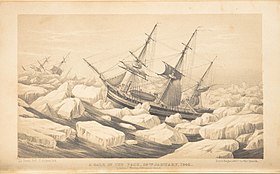 A Gale in the Pack


From 1844 until 1862 Davis worked as a surveyor in home waters, first as assistant-surveyor to Captian G.A. Bedford on the west coast of Ireland, then on the south coast of England with Lieutenant H.L. Cox and then with Staff-Commander Usborne. In 1862 he sailed with HMS Porcupine on a deep-sea sounding cruise to the north-west of Ireland. This was succesful in finding a suitable route for a transatlantic cable, avoiding the precipitous slopes that mark much of the edge of the continental shelf.[14][15] Davis was commended in official reorts for his contributions to this work. He then became a naval assistant to the Admiralty, responsible for supervision of deep-sea sounding equipment and for maintaining the catalogue of official documents.[2] He published a number of works on the technical aspects of surveying and exploration, in particular on deep-sea temperature measurement.[14] He was promoted Staff-Commander in 1863, and to Captain in 1870. He retired from the Hydrograhic Office in 1877, and died later that year.[2]
Bibliograhy edit
- Davis, John Edward (1867). Notes on Deep-sea Sounding. Hydrographic Office of the Admiralty.
- —— (1869). "On Antarctic Discovery and Its Connection with the Transit of Venus in 1882". The Journal of the Royal Geographical Society of London. 39: 91–95.
- —— (1871). "On Deep-sea Thermometers". Proceedings of the Meteorological Society. 5: 305–342.
- ——; Davis, Percy L.H. (1887). Sun's true bearing or azimuth tables. London: J.D. Potter.
References edit
- ^ a b c Hoskyn, Rd. (1842). "Narrative of a Survey of Part of the South Coast of Asia Minor; And of a Tour into the Interior of Lycia in 1840-1; Accompanied by a Map". Journal of the Royal Geographical Society of London. 12: 143. doi:10.2307/1797993. ISSN 0266-6235.
- ^ a b c d e f g h i Dawson, Llewellyn Styles (1885). Memoirs of hydrography, including brief biographies of the principal officers who have served in H.M. Naval Surveying Service between the years 1750 and 1885. Part 2. - 1830-1885. Eastbourne: Henry W. Keay. pp. 118–119. Cite error: The named reference "Memoirs" was defined multiple times with different content (see the help page).
- ^ The Navy List. H.M. Stationery Office. 20 September 1835. p. 68.
- ^ "Appointments". The Nautical Magazine: 446. 1836.
- ^ A List of the Commissioned Officers and Passed Clerks of Her Majesty's Royal Navy with the Dates from which they take Rank. 1845. p. 129.
- ^ Özer, Yasemen Say; Özer, Nevzat Oguz (2017). "Formal Analysis and Principal Architectural Character of Caunus Theater". Megaron. 12 (2): 173–183. doi:10.5505/MEGARON.2017.64436.
- ^ "Collecting and empire". British Museum. Retrieved 19 January 2023.
- ^ "Appointments". The Nautical Magazine: 319. 1844.
- ^ Hoskyn, Richard (1866). Sailing directions for the coast of Ireland, Part 1. South, East, and North, Coasts of Ireland. London: Hydrographic Office of the Admiralty. Second edition 1877
- ^ Hoskyn, Richard (1868). Sailing directions for the coast of Ireland. Part 2. South-west, West, and North-west Coasts. London: Hydrographic Office of the Admiralty.
- ^ Ritchie, G.S. (1967). The Admiralty Chart. London: Hollis & Carter. pp. 320–321.
- ^ "John Edward Davis". Christie's. Retrieved 6 January 2023.
- ^ Ross, James Clark (1847). A Voyage of Discovery and Research in the Southern and Antarctic Regions, during the Years 1839-43. London: John Murray. Volume 1; Volume 2.
- ^ a b Deacon, Margaret B. (1971). Scientists and the Sea 1950-1900: a study of marine science. Academic Press. p. 297.
- ^ Rice, Tony (1986). British Oceanographic Vessels 1800-1950. The Ray Society. p. 119. ISBN 0-903874-19-9.
External links edit
Category:Royal Navy officers Category:1815 births Category:1877 deaths
.jpg)
Edward Killwick Calver (6 December 1813 - 28 October 1892) was a Captain in the Royal Navy, and hydrographic surveyor. He is particularly noted for his suveying work in the east of Britain, and as the captain of HMS Porcupine, in oceanographic voyages in 1869 and 1870.
Calver was born in Southwold in Suffolk.[1] He entered the Navy in July 1828 on board HMS Crocodile on foreign service in the East Indies, where he was active in the search for pirates. In 1832 he joined HMS Satellite, under the command of Robert Smart, being involved in the blockade of the Dutch Coast during the Belgian war of independence,[2] and then cruising for slavers off the coast of Brazil. He passed his examination for Second-Master in October 1834, and carried out many surveys, both in Crocodile and Satellite. His surveying work was sufficiently appreciated at home that when he returned to England in April 1836 he was appointed Assistant-Surveyor to Michael Atwell Slater who was in charge of the survey of the east coast of Scotland.[3]

In 1841 Calver was appointed Acting-Master on HMS Shearwater[4] and Assistant-Surveyor to Captain John Washington, who was completing the great survey of the North Sea which had occupied Captain William Hewett for 10 years until the loss of his ship HMS Fairy with all hands in 1840.[5] He was promoted to Master in January 1842. Washington and Calver then transferred from Shearwater to HMS Blazer, and continued survey work in the North Sea until 1847.[3][6] During this period Calver was involved in both deep-water surveying, and in making plans of Scarborough and the port of Harwich, the Rivers Orwell Stour and Deben, and the approaches to Yarmouth and Lowestoft Roads.[3][7][8]

He gave evidence to the Commission on Harbours of Refuge, and also prepared several of the plans used by the committe in preparing its report.[3][9] Throughout his career he was concerned with the improvements of tidal harbours and entrances.[1]
From 1847 until 1872 Calver was in charge of the survey of the east coast of England, first commanding HMS Speedwell,[10] then from 1863 in HMS Porcupine.[11][12] He surveyed most of the east coast of England, including rivers and harbours, as well as the offshore sandbanks and channels. He compiled sailing directions for much of the North Sea, including parts of the continental coast.[3] He also carried out surveys on the west coast of Britain during this period including the work that led to the publication of sailing directions for the Bristol Channel.[13] He was promoted to Staff-Commander in June 1863, and to Staff Captain in March 1870.[1][3]

Calver was in command of Porcupine for her most famous voyages, the oceanographic cruises in 1869 and 1870 directed by Charles Wyville Thomson and sponsored by the Royal Society. The first cruise was off the west of Ireland in May to July 1869. Dredge hauls and temperature measurement were made in depths up tp 1476 fathoms (2700m). The second cruise, from 17 July to 4 August 1869 was to an area west of Ushant and south-west of Ireland and aimed to sample much deeper water than had previously been obtained. They obtained a dredge at 2435 fathoms (4289m), by far the deepest to date. The sample included a wide range of animal life, disproving the Azoic hypothesis, that life could not exist below about 300 fathoms. From 15 August to 15 September 1869, the ship explored the area between Shetland, the Faroes, and the north of Lewis. They confirmed a finding of markedly different temperatures in neighbouring areas of the ocean, irrespective of depth. These findings, though controversial, suggested a deep circulation driven by density differences.[11] The final cruise was to the Mediterranean, from July to October 1870. The most important findings related to water temperatures and circulation. In the Strait of Gibraltar they found a salinity maximum at about 250 fathoms (457 metres). Using a current drag designed by Calver they were able to show an outward flow of water at this depth, in contrast to the surface current which flowed inward.[14]: 164-165 The success of the Porcupine voyages led to the funding of the Challenger expedition of 1872-1876, which surveyed deep seas around the world.[11]
Calver retired from active service in 1872, with the rank of Captain. In the following year he was elected a fellow of the Royal Society. He died at Vevey in Switzerland in 1892.[1]
References edit
- ^ a b c d "Captain Edward Killwick Calver, R.N. (retired)". Minutes of the Proceedings of the Institution of Civil Engineers. 112: 373–374. 1893. doi:10.1680/imotp.1893.20057.
- ^ Sir William Laird Clowes (1897). The Royal Navy. A history from the earliest times to the present. By W. L. Clowes ... assisted by Sir Clements Markham ... Captain A. T. Mahan ... Mr. H. W. Wilson, Mr. Theodore Roosevelt, Mr. E. Fraser, etc. ... Illustrations, maps, etc. Vol. VI. Sampson Low & Company. p. 271. OCLC 752918648.
- ^ a b c d e f Dawson, Llewellyn Styles (1885). Memoirs of hydrography, including brief biographies of the principal officers who have served in H.M. Naval Surveying Service between the years 1750 and 1885. Part 1. - 1750 to 1830. Eastbourne: Henry W. Keay. pp. 115–117.
- ^ "Appointments". Nautical Magazine: 142. 1842.
- ^ "The North Sea - Sheet 1 - From Dover and Calais to Orfordness and Scheveningen (Review of chart)". Nautical Magazine. 10: 289–291. 1845.
- ^ "Appontments". Nautical Magazine: 213–214. 1843.
- ^ Washington, John (1843). "On the New Stanford Channel, Lowestoft Roads". Nautical Magazine: 262–264.
- ^ Washington, John (1843). "Harwich Harbour". Nautical Magazine: 338–341.
- ^ a b Report of the Commissioners upon the subject of harbours of refuge. London: H.M. Stationery Office. 1844.
- ^ "Her Majesty's Ships in Commission". Nautical Magazine: 498. 1848.
- ^ a b c Rice, Tony (1986). British Oceanographic Vessels 1800-1950. The Ray Society. pp. 118–124. ISBN 0-903874-19-9.
- ^ Ritchie, G.S. (1967). The Admiralty Chart. London: Hollis & Carter. p. 322.
- ^ Bedford, E.J. Sailing Directions for the Bristol Channel. London: Hydrographic Office of the Admiralty.
- ^ a b Carpenter, William Benjamin; Jeffreys, John Gwyn (1871). "Report on deep-sea researches carried on during the months of July, August, and September 1870, in HM surveying-ship Porcupine". Proceedings of the Royal Society of London. 19: 145–221.
Publications edit
- Calver, E.K. (1843). "On Bar Harbours". Nautical Magazine: 595–598.
- —— (1853). The Conservation and Improvement of Tidal Rivers: Considered Principally with Reference to Their Tidal and Fluvial Powers. London: John. Weale.
- —— (1856). Proposals for the improvement of Southwold harbour.
- —— (1857). On the best site for a harbour of refuge on the east coast of England.
- —— (1858). On the Construction and Principle of a Wave Screen, Designed for the Formation of Harbours of Refuge. London: John Weale.
- —— (1876). The cry for national harbours, and its connection with our defective system of public harbour legislation. London.
{{cite book}}: CS1 maint: location missing publisher (link)
Calver contributed to the following volumes of sailing directions:
- North Sea Pilot Part IV. River Thames and Medway, and the shores of the North Sea from Calais to the Skaw. London: Hydrographic Office of the Admiralty. 1863. The directions from Dunkerque to the Elbe are by Mr. E. K. Calver, Master, R.N., from the charts of Ryk and Van Rhyn, the Dutch Ariel by Modera, and other authorities, as well as from his own observations.
- North Sea Pilot Part 1 Shetland and Orkneys. Second Edition. London: Hydrographic Office of the Admiralty. 1876. The directions for Shetland were prepared by Mr. E. K. Calver, Master, R.N., from materials supplied by the late Commander G. Thomas.
- Bedford, E.J. (1879). Sailing Directions for the Bristol Channel. London: Hydrographic Office of the Admiralty. Originally written in 1858 by Mr. E.K. Calver, Master, R.N.. Recompiled by Bedford, and published in 1869. This edition revised 1879.
- North Sea Pilot Part III East Coast of England, Fifth Edition. London: Hydrographic Office of the Admiralty. 1889. The work was originally prepared in 1857 by Staff Commander E. K. Calver, R.N., who had been employed on the survey of this coast from the year 1836. The second edition was published in 1869,
The Edinburgh Channels, formerly a single channel known as the Bullock Channel and then the Duke of Edinburgh Channel are two roughly parallel transverse channels in the Thames Estuary. They used to be important for navigation, providing a deep approach to the River Thames from the south-east through the sandbanks of the estuary. The opening of an alternative channel in 2000 has greatly reduced their use, but having been surveyed and studied extensively over the past two centuries they provide an important example of the processes that shape shallow water landforms.
Backgound edit
The Thames Estuary and the adjacent part of the North Sea is an area of shallow water with many sandbanks and channels, and substantial tidal currents, often 2-2.5 knots at springs.[1] On the flood, the main tidal flow comes from the north, and then passes in a south-westerly direction towards the river mouth. It is the scouring action of this current that determines the main pattern of banks and channels, which run in a SW -NE direction. A secondary tidal current arrives from the Strait of Dover 2-3 hours after the peak of the main flow. This current passes into the estuary from the south-east, and has cut several transverse channels or swatchways, across the banks, including the Edinburgh Channels. On the ebb tide the pattern is reversed with similar speeds and timings.

![The main tidal flow from the north, flood tide.[1]](/wiki/File:Thames_estuary_tidal_streams_Page006_4_hours_before_H.W._Sheerness.jpg)
![The secondary tidal flow from the south, two hours later, flood tide.[1]](/wiki/File:Thames_estuary_tidal_streams_Page008_2_hours_before_H.W._Sheerness.jpg)
History edit

Thomas Henry Tizard, surveyor and oceanographer, has presented an account of the changes in the area from the survey by George Thomas in 1810 to his own work in 1882 and 1889.[2] In 1810 there was a channel with 30 foot depth known as Thomas's New Channel, and an inlet to the south-west of it. When surveyed by Frederick Bullock in 1839, Thomas's channel had narrowed and shoaled, but the inlet noted by Thomas had opened into a new channel with 18 feet depth, which was named Bullock's channel. The next survey in 1862, by Edward Calver, showed that Bullock's Channel had deepened and widened, with a depth of 42 feet, but that Thomas's channel had completely closed. Tizard's first survey was in 1882 in connection with the marking of the channel by buoys. At this time the channel was renamed the Duke of Edinburgh Channel in honour of Prince Alfred, Master of Trinity House. Tizard noted the presence of a shallower patch, with a depth of 30 feet, near the centre of the channel. The channel was lighted in 1889, with two lightships and three gas-lighted buoys.[3] Tizard noted 1n 1889 that the patch had bcome shallower, and was about a mile in length.[2]

In the mid-nineteenth century, most shipping into the Thames from the south-east used the Princes and Alexandra Channels, to the south of Shingles. As vesels became larger and with deeper draught these channels became insufficient, and the Duke of Edinburgh Channel became increasingly important. The patch in the middle, now known as Shingles Patch, became larger and shallower, and by 1910 had divided the channel into two, now known as the North and South Edinburgh channels, both being used for navigation. By 1933 Shingles Patch had shoaled sufficently that part of it dried at low water, and it had also shifted north, causing the north channel to become narrower.[4]
Fisherman's Gat, a swatchway to the north-east of the Edinburgh Channels, became steadliy deeper from the 1950s on, making it increasingly attractive as an alternative to the Edinburgh Channels.[5] It was buoyed and opened to shipping in 2000.[6]
Current status edit
The Edinburgh channels are now unmarked, and no longer used by commercial shipping, but are still used by smaller craft.[7][8]
References edit
- ^ a b c Thames Estuary. Pocket tidal stream atlas & co-tial chart. UK Hydrographic Office. 1958.
- ^ a b c Tizard, T. H. (1890). "The Thames Estuary". Nature. 41 (1067): 539–544. doi:10.1038/041539a0. ISSN 0028-0836.
- ^ "Thames Navigation". Nautical Magazine. 59: 25–28. 1890.
- ^ Robinson, A.H.W. (1946). The Thames Estuary. I. Hydrographic History. Document OPT 217. United Kingdom Hydrographic Office.
- ^ Burningham, H.; French, J.R. (2009). Seabed mobility in the greater Thames estuary. Crown Estate. p. 27. ISBN 978-1-906410-09-4.
- ^ THAMES ESTUARY FISHERMAN’S GAT. ASSESSMENT ON THE ANALYSIS OF ROUTINE RESURVEY AREA TE19 FROM THE 2005 SURVEY. Archived 4 August 2008 at the Wayback Machine UK Hydrography Office. 2005. Accessed 18 July 2008.
- ^ Sailing Directions (enroute): North Sea. Springfield, Virginia: National Geospatial-Inelligence Agency. 2022. pp. 122–123.
- ^ Reeds Eastern Almanac 2022. Bloomsbury Publishing. 2021. p. 277. ISBN 978-1-4729-9057-0.
Discovery edit
Sumner discovered the line on a voyage from South Carolina to Greenock in Scotland in 1837. On December 17, as he was nearing the coast of Wales, he was uncertain of his position after several days of cloudy weather and no sights. A momentary opening in the clouds allowed him to determine the altidude of the sun. This, together with the chronometer time and the latitude enabled him to calculate the longitude. But he was not confident of his latitude, which depended on dead reckoning (DR). So he calculated longitude using his DR value and two more values of latitude 10' and 20' to the north. He found that the three positions were on a straight line which happened to pass through Smalls Lighthouse. He realised that he must be located somewhere on that line and that if he set course E.N.E. along the line he should eventually sight the Smalls Light which, in fact he did, in less than an hour. Having found the line empirically, he then worked out the theory, and published this in a book in 1843. The method was quickly recognized as an important development in celestial navigation, and was made available to every ship in the United States Navy.[1]
Description edit

The line of equal altitude for a celestial object is a circle with its centre at the point on the earth directly below the object, A in the diagram. Thus the altutude of the object at A is 90°. BB'B'', CC'C'' and DD'D'' are circles of equal altitude. As the circles generally used for navigation have a radius of thousands of miles, a segment a few tens of miles long closely approximates a straight line, as described in Sumner's first use of the method.
a sight of the sun which he reduced with his estimated latitude. Measuring the longitude depended on knowing the time, fron his chronometer, and the latitude accurately. Being uncertain about the latitude he reduced the sight again using 10' greater and 20' greater latitude, plotted the longitude for each one, and he observed that all three resulting positions were located on a line which also happened to pass through Smalls Lighthouse (off the coast of Pembrokeshire in Wales).[3]: 37–39 [4]: 56 He reasoned that he must be located somewhere on that line and that if he set course E.N.E. along the line he should eventually sight the Smalls Light which, in fact he did, in less than an hour.[2] He realized that a single observation of the altitude of a celestial body at a known time determines the position of a line somewhere on which the observer is located. The line of equal altitude is actually a circle, centered on the point on the globe at which the sun (in the case of a solar observation) is directly overhead, the subsolar point. As the circle has a radius of thousands of miles, a segment a few tens of miles long closely approximates a straight line.[4]: 449–453 Sumner published his findings six years later in 1843[3] and this method of resolving a sight for two different latitudes and drawing a "line of position" through the two positions obtained was an important development in celestial navigation. The method was quickly recognized as important and a copy of the pamphlet describing the method was supplied to every ship in the United States Navy.[2]
On 17 Dec 1837, the subsolar position was at Latitude: 23° 23' South, Longitude: 29° 06' East: https://www.timeanddate.com/worldclock/sunearth.html?day=17&month=12&year=1837&hour=10&min=00&sec=0&n=&ntxt=&earth=0
References edit
- ^ Richardson, Robert S. (1943). "Captain Thomas Hubbard Sumner, 1807-1876". Publications of the Astronomical Society of the Pacific. 55 (324): 136–144. JSTOR 40669797.
- ^ Bowditch, Nathaniel; United States Hydrographic Office (1943). American Practical Navigator. An epitome of navigation and nautical astronomy. Washington: U.S. Government Printing Office. p. 178.
- ^ Appleton, William Sumner (1879). Record of the Descendants of William Sumner, of Dorchester, Mass., 1636. Boston: D. Clapp & Son.
Adrian Henry Wardle Robinson (born 12 June 1925) was a British geographer noted for his work on shallow water oceanography and on the history of marine surveying.
Robinson became a fellow of the Royal Geographical Society in 1945.[1] After working as a cartographer in the Hydrographic Office of the Admiralty, he obtained an MSc at London University in 1952. He worked at the University of Leicester, as Lecturer in Geography. from 1952. He received his PhD, also from London, in 1960, and became Reader at Leicester in 1969.[2] He carried out considerable research into the factors affecting coasts and shallow waters, particularly in sandy bays and estuaries, and in harbour entrances. He was also occupied with the history of marine surveying and cartography of Britain, publishing several journal articles as well as his highly regarded book Marine Cartograohy in Britain, with many illustrations by his wife, herself a former cartographer.[3][4][5] During the 1970s, Robinson collaborated with Roy Millward, also of the University of Leicester, in a series of books on the Landscapes of Britain, as well as on the The Shell Book of the British Coast (1983).[6]
References edit
- ^ "Meetings: Session 1945-46". The Geographical Journal. 106 (3/4): 168. 1945. JSTOR 1789277.
- ^ Grant, John (1971). Who's who of British Scientists 1971-72. Longmans. p. 772. ISBN 978-0-58-211464-7.
- ^ Ritchie, G.S. (1963). "Early English Charting - Marine Cartography in Britain, A. H. W. Robinson". Journal of Navigation. 16 (1): 140–142. doi:10.1017/S0373463300018579.
- ^ Deacon, G.E.R. (1965). "Marine Cartography in Britain: A History of the Sea Chart to 1855. A. H. W. Robinson". Isis. 56 (2): 226–228. doi:10.1086/349975. JSTOR 227933.
- ^ Stevenson, D.Alan (1965). "Marine cartography in Britain: A Review". Scottish Geographical Magazine. 81 (1): 59. doi:10.1080/00369226508735954.
- ^ Millward, Tim. "Roy Millward (1917–2016)". Royal Geographical Society. Retrieved 6 December 2022.
Selected bibliography edit
- Robinson, A.H.W. (1951). "The early hydrographic surveys of the British Isles". Empire Survey Review. 11 (80): 60–65. doi:10.1179/sre.1951.11.80.60.
- —— (1951). "The Changing Navigation Routes of the Thames Estuary". The Journal of Navigation. 4 (4): 357–370. doi:10.1017/S0373463300034226.
- —— (1952). "The Evolution of the English Nautical Chart". Journal of Navigation. 5 (4): 362–374. doi:10.1017/S0373463300045070.
- —— (1953). "Some hydrographic surveyors of the early nineteenth century". Empire Survey Review. 12 (90): 146–152. doi:10.1179/sre.1953.12.90.146.
- —— (1955). "The Harbour Entrances of Poole, Christchurch and Pagham". The Geographical Journal. 121 (1): 33–50. JSTOR 1791805.
- —— (1956). "The Submarine Morphology of certain Port Approach Channel Systems". The Journal of Navigation. 9 (1): 20–46. doi:10.1017/S0373463300046749.
- —— (1957). "Marine Surveying in Britain during the Seventeenth and Eighteenth Centuries". The Geographical Journal. 123 (4): 449–456. JSTOR 1790346.
- —— (1958). "The charting of the Scottish coasts". Scottish Geographical Magazine. 74 (2): 116–127. doi:10.1080/00369225808735714.
- —— (1959). "Two unrecorded manuscript charts by John Adair". Scottish Geographical Magazine. 75 (3): 169–172. doi:10.1080/00369225908735762.
- —— (1960). "Ebb-flood channel systems in sandy bays and estuaries". Geography. 45 (3): 183–199. JSTOR 40565158.
- —— (1961). "The Hydrography of Start Bay and Its Relationship to Beach Changes at Hallsands". The Geographical Journal. 127 (1): 63–77. JSTOR 1793197. OCLC 62431872.
- —— (1962). Marine Cartography in Britain: A History of the Sea Chart to 1855. Leicester University Press. OCLC 62431872.
- —— (1964). "The inshore waters, sediment supply and coastal changes of part of Lincolnshire". East Midland Geographer. 3 (22): 307–322.
- —— (1965). "The Mapping of Hydrographic Data in Atlases - Plea for Morphological Maps". The International Hydrographic Review. 42 (1).
- —— (1966). "Residual currents in relation to shoreline evolution of the East Anglian coast". Marine Geology. 4 (1): 57–84. doi:10.1016/0025-3227(66)90037-5.
- —— (1968). "The use of the sea bed drifter in coastal studies with particular reference to the Humber". Zeitschrift für Geomorphologie. 7: 1–23.
- —— (1968). "The Submerged Glacial Landscape off the Lincolnshire Coast". Transactions of the Institute of British Geographers (44): 119–132. JSTOR 621752.
- ——; Wallwork, Kenneth L. (1970). Map Studies with Related Field Excursions. Longman. ISBN 978-0-58-231067-4.
- Millward, Roy; Robinson, Adrian. Landscapes of Britain series: The Lake District(1970); South East England (1971); The West Midlands (1971); The South - West Peninsula (1971); The Welsh Marches (1971); Cumbria (1972) South East England-the channel coastlands (1973); The Peak District (1975); The Welsh Borders (1978); Landscapes of North Wales (1978); Upland Britain (1980).
- Millward, Roy; Robinson, Adrian (1983). The Shell Book of the British Coast. David & Charles. ISBN 978-0-71-538150-2.
Warning: Default sort key "Robinson, Adrian Henry Wardle" overrides earlier default sort key "Schiehallion Experiment". Category:1925 births Category:Alumni of the University of London Category:Academics of the University of Leicester Category:British geographers Category:Fellows of the Royal Geographical Society
This biography article of a United Kingdom academic is a stub. You can help Wikipedia by expanding it. |

Michael Atwell Slater (died 2 February 1842) was a Royal Navy Officer and hydrographic surveyor particularly noted for his survey work in the north-east of Engand and the east of Scotland.
Biography edit

Slater's date of birth is not known. His father, Joseph Slater of Bromley, and his brother, Joseph Slater Jr. were both artists.[1][2] Michael Slater entered the Royal Navy in 1811, and in 1816 was surveying in the Mediterranean as an assistant to William Henry Smyth. He started working in Great Britain in 1829, surveying the coasts of Durham, Northumbrland and eastern Scotland.[3] His work led to the publication of over 20 Admiralty Charts[4], and he contributed to the North Sea Pilot Part 2 - sailing directions for the North and East Coasts of Scotland[5]. He was promoted to Commander in 1837.[6]
Surveying work was used for planning purposes, as well as for navigation. In 1839 Slater gave evidence to a Parliamentary committee considering improvements to the Caledonian Canal. He described the hazards in the approach to the canal through the Moray Firth and the Kessock Narrows, and made recommendations for the location of buoys and lights.[7]

He died on 2 February 1842, falling from Holborn Head, a cliff near Scrabster. very likely by suicide.[8] He left a widow, Antonetta, but had no children.[9][6] His assistant Henry Charles Otter then took over the survey of Scotland, continuing around to the the west of Scotland.[10][11]
References edit
- ^ "Joseph Slater (circa 1750-1805?), Painter". National Portrait Gallery. Retrieved 23 November 2022.
- ^ Binyon, Laurence (1907). Catalogue of Drawings by British Artists and Artists of Foreign Origin Working in Great Britain, Preserved in the Department of Prints and Drawings in the British Museum. London: British Museum. p. 104.
- ^ Dawson, Llewellyn Styles (1885). Memoirs of hydrography, including brief biographies of the principal officers who have served in H.M. Naval Surveying Service between the years 1750 and 1885. Part 1. - 1750 to 1830. Eastbourne: Henry W. Keay. p. 127.
- ^ Admiralty Catalogue of Charts, Plans, Views, and Sailing Directions, &c. London: H.M. Sationery Office. 1857.
- ^ Otter, H.C.; Slater, M.A; Thomas, G. (1857). North Sea Pilot Part 2, North and East Coats of Scotland.
- ^ a b "Obituary: Commander Michael Slater". The Nautical Magazine: 208–209. 1842.
- ^ Report from the Select Committee of the Caledonian and Crinan Canals together with the minutes of evidence and appendix. Great Britain Parliament House of Commons. 1839. pp. 1–7.
- ^ Walker, David L. (2022). "Slater's Loup and Monument - and his successor, Henry Otter" (PDF). Cairt (40): 2–4.
- ^ Great Britain. Parliament. House of Commons (1839). Parliamentary Papers: 1780-1849, Volume 8, Part 1. H.M. Stationery Office. p. 59. OCLC 12697463.
- ^ Dawson, Llewellyn Styles (1885). Memoirs of hydrography, including brief biographies of the principal officers who have served in H.M. Naval Surveying Service between the years 1750 and 1885. Part 2. - 1830-1885. Eastbourne: Henry W. Keay. pp. 34–35.
- ^ Ritchie, G.S. (1967). The Admiralty Chart. London: Hollis & Carter. p. 240.
Further Reading edit
- "Captain Michael Slater". Hole Ousia. Retrieved 23 November 2022.
External links edit
Category:Royal Navy officers Category:1842 deaths
George Henry Falkiner Nuttall FRS (5 July 1862 – 16 December 1937) was an American-British bacteriologist who contributed much to the knowledge of parasites and of insect carriers of diseases. He made significant innovative discoveries in immunology, about life under aseptic conditions, in blood chemistry, and about diseases transmitted by arthropods, especially ticks. He carried out investigations into the distribution of Anopheline mosquitoes in England in relation to the previous prevalence of malaria there. With William Welch he identified Clostridium perfringens, the organism responsible for causing gas gangrene. He also demonstrated the importance of intestinal bacteria in digestion and investigated the bactericidal properties of blood.
Life edit
Nuttall was born in San Francisco, the second of three sons and two daughters of Robert Kennedy Nuttall, a British doctor who had migrated to San Francisco in 1850, and Magdalena, daughter of John Parrott of San Francisco. In 1865 the family moved to Europe. The children were educated in England, France, Germany and Switzerland. As a result Nuttall spoke German, French, Italian and Spanish, which was extremely useful in his later career. Nuttall returned to the United Sates in 1878, obtaining his M.D. degree from the University of California, Berkeley in 1884. He then travelled with some of his family to Mexico for a year. His sister Zelia became a noted archaeologist and anthropologist of early Mexican cultures.[1][2][3][4][5]
After a short period working at Johns Hopkins University in Baltimore under H. Newell Martin, he went to Göttingen in 1886 working with Carl Flügge and others. His research in Göttingen included studies on mechanisms of immunity. He received his PhD in Zoology in 1890.[6] After a year travelling he returned to Baltimore, working under William H. Welch and becoming Associate in Hygiene in 1892. He worked on the tubercle bacillus and on the bacillus responsible for gas gangrene.[1]

From 1892-1899 Nuttall was in Germany once more, first in Göttingen, then in Berlin, where he worked at the Hygienic Institute (hygienischen Institut). He married Paula von Oertzen-Kittendorf in 1895. Working with Hans Thierfelder he developed methods for rearing guinea pigs under aseptic conditions, with no gut bacteria.[8] This work laid the foundation for the field of Gnotobiosis, the study of organisms with known micro-organism populations.[9][10] In 1895 he designed a microscopic thermostat for maintaining biological materials under studiy at a constant temperature. This was used for many years.[1][7] During this period his interest in the role of insects in transmission of disease developed, which would be a major concern for the rest of his life.[1]
In May 1899 Nuttall travelled to Cambridge at the invitation of Clifford Allbutt, Regius Professor of Physic at the University, and gave a series of lectures in bacteriology. In 1900 he was appointed University Lecturer in Bacteriology and Preventive Medicine, and would be based in Cambridge for the rest of his life. He founded and edited the Journal of Hygiene, the first volume being published in 1901. His research at this period was in two main areas, studies of blood, in particular immune reactions, and studies on transmission of disease by arthropods, in particular mosquitoes and malaria with Arthur Shipley. In 1904 Nuttall and Shipley were both elected Fellows of the Royal Society. In the same year he and Patrick Manson established in Cambridge the first Diploma in Tropical Medicine and Hygiene, which continued until 1933.[1]
In 1906 he was elected the first Quick Professor of Biology at Cambridge, a chair established for the study of protozoology. He built a substantial team within the Quick Laboratory working on many areas of parasitology. A major topic was piroplasmosis and related malaria-like parasites transmitted by ticks, mainly in dogs, but also in other animals including humans. The number of published papers on parasitology was steadily increasing, and in 1908 Nuttall founded Parasitology, initially as a supplement to the Journal of Hygiene, but soon as a separate journal. Also in 1908 he was elected a felllow of Magdalen College. During World War I he began to investigate lice. This began in response to the practical problems with lice in the troops, but developed over the next few years into research on their biology and role in disease.[1]
In 1919 Nuttall appealed for funds to create an Institute for Parasitical Research in Cambridge. Percy Molteno and his wife donated the sum of £30,000 for this purpose. The Molteno Institute for Research in Parasitology was opened in in 1921 with Nuttall as its first Director.[11] The Quick Department was transferred to the Molteno Institute.[1]
After the establishment of the Molteno Institute, Nuttall became increasingly occupied with adminisration and fundraising, and published few papers. His wife Paula died in 1922. He resigned the Quick Professorshipin 1931, and became Emeritus Professor of Biology. He died suddenly in December 1937, and was survived by two sons, George and Winfred, and a daughter Carmelita.[1][5] His ashes were buried in Tunbridge Wells, Kent.[12]
Mechanisms of Immunity edit
In the early 1880s, Metchnikoff had observed phagocytosis of bacteria and other foreign matter by animal cells including leucocytes in mammmals, and proposed that this was the mechanism by which animals protect themselves against infection. This idea was controversial at the time. Josef von Fodor had shown an apppparent germicidal action of blood against anthrax bacilli,[13] but critics suggested that the bacilli were being entrapped by clotting rather than destroyed.[14] Nuttall, carried out a series of experiments with defibrinated blood from various species, and clearly established the germicidal action of blood in the absence of clotting, and also that the germicidal action was lost after the blood was heated to 55°C.[15] These results formed the basis of the humoural theory of immunity, as opposed to the cellular theory of Metchnikoff, and also stimulated the work that led to the development of antitoxin therapy, particularly for diphtheria and tetanus.[5] Initially the humoural and cellular theories were seen as rival explanations of immunity, but it soon became clear that processes of both kinds occur and complement one another.[16][17][18]
Phylogenetic relationships edit
Darwin's theory of Evolution - descent with modification - provided a theoretical basis for classification in biology, species within a taxon sharing a more or less recent common ancestor. For nearly half a century, the only criteria for classification remained morphological, as had been the case with pre-evolutionary systems such as that of Linnaeus. Classification based on morphology has two main limitations: dificulty in dealing with convergent evolution where similar forms arise in species that are not closely related; and an inability to provide a quantitative measure of relatedness.[19]: 102 The precipitin reaction was first described by Kraus in 1897, an insoluble product being formed in an antigen-antibody interaction.[20] The reaction was at first thought to be specific, but it was soon found that while the protein used to generate the antibody gave the strongest reaction, related proteins could give lesser reactions. This finding was developed by Nuttall into a quantitative method in which the amount of precipitate was measured. Using serum from a wide variety of animals he was able to show that the degree of immune reaction between sepcies indicated the relationship between them.[21][22][19] In a major work Blood immunity and blood relationship Nuttall and his colleagues presented the data from over 16,000 tests with serum from a wide range of animal species, both vertebrate and invertebrate.[23] This work was the starting point for the field of molecular evolution.[24][25]
Arthropods as disease vectors edit

In 1900 Nuttall and Austen published a book reviewing the evidence for transmission of disease by Insects, Arachnids and Myriapods, which included a discussion of the mosquito theory of malaria.[27] Malaria had formerly been common in England, but few if any cases still occurred in 1900. Nuttall and colleagues carried out a survey of the distribution of the Anopheles mosquito in England, showing a concentration in the areas where malaria (Ague) had previously been prevalant. The study suffered from the limitation of not distinguishing between the various species of mosquito, but its presentation, including maps, was one of the first of its kind.[28][1][29] Nuttall and Shipley subsequently published a series of papers in The Journal of Hygiene on the structure and biology of Anopheles (1901-1903), which represented the most detailed study on the topic up to that time.[1]


Nuttall began working on ticks and tick-transmitted diseases in 1904.[1] His first studies were with canine piroplasmosis. Piroplasmosis, or babesiosis, unknown in Britain, is a malaria-like disease caused by a protozoan parasite. At one stage in its life-cycle the parasite is pyriform (pear-shaped), hence the name piroplasmosis.[31] It affects a wide variety of wild and domestic animals. Human cases occur, but are uncommon. Smith and Kilborne identified the parasite in Texas cattle fever, and established that it was transmitted by ticks, the first proven case of arthropod disease transmission.[32][33] In a series of papers published with Graham-Smith in The Journal of Hygiene (1904-1907) Nuttall described the nature of the disease and the multiplication of the parasite in the blood of dogs. Subsequent work with Seymour Hadwen led to the discovery that trypan blue was an effective treatment both in dogs and cattle.[34][35] This was a finding of great economic importance, and trypan blue became the standard treatment for piroplasmosis/babesiosis for many years.[1][5][36]

Nuttall made extensive studies on ticks in collaboration with Cecil Warburton L.E. Robinson and F.W. Cooper. This led to numerous papers and an exhaustive monograph that appeared in three parts between 1908 and 1915.[38] The publications, mostly in the jurnal Parasitology cover the anatomy, biology and classification of ticks, as well as observations on the diseases they transmit, including "tick paralysis".[39] In the course of this work, Nuttall accumulated a very large collection of ticks from many parts of the world.[1] The collection is now in the Natural history museum.[5]
Another arthropod, that became increasingly important during World War I was the louse. Nuttall, carried out a series of studies that, as with many of his other researches, combined a theoretical and zoological approach with practical concerns.[40][41]
His writings include some 150 articles in professional journals.[42]
He published:
- Hygienic Measures in Relation to Infectious Diseases (1903)
- Blood Immunity and Blood Relationship (1904), establishing the identification of different kinds of blood[43]
- The Bacteriology of Diphtheria (1908), with George Stuart Graham-Smith and others
- Ticks (1908 et. seq.), with C. Warburton and others
- The Drug Treatment of Canine Piroplasmosis (1910)
- Russian Ixodoidea (1912)
- The Training and Status of Public Health Officers in the United Kingdom (1913)
Parasites named for him edit
- Nuttallia — Small protozoan parasites found in the red blood corpuscles of horses and dogs.
- N. equi, a species causing hemoglobinuric fever of horses in South Africa. It is probably transmitted by the tick Rhipicephalux everti. Called also Babesia equi and B. caballi.
- N. gibso'ni is found in dogs.
- Nuttalliellidae — Tick family found in southern Africa[44][circular reference]
- Nuttaliella, Tick genus within the family Nuttalliellidae
References edit
- ^ a b c d e f g h i j k l m n Graham-Smith, G.S. (1938). "George Henry Falkiner Nuttall (5 July 1862-16 December 1937)". The Journal of Hygiene. 38 (2): 129–140. JSTOR 3859868.
- ^ Graham-Smith, G. S.; Keilin, D. (1939). "George Henry Falkiner Nuttall. 1862-1937". Obituary Notices of Fellows of the Royal Society. 2 (7): 492. doi:10.1098/rsbm.1939.0009. JSTOR 769002.
- ^ K.D. (1938). "Prof. G. H. F. Nuttall, F.R.S". Nature. 141 (3564): 318–319. Bibcode:1938Natur.141..318K. doi:10.1038/141318a0.
- ^ "The Oxford Dictionary of National Biography". Oxford Dictionary of National Biography (online ed.). Oxford University Press. 2004. doi:10.1093/ref:odnb/35271. (Subscription or UK public library membership required.)
- ^ a b c d e Keirans, James E. (1984). George Henry Falkiner Nuttall and the Nuttall Tick Collection. Miscellaneous publication (United States. Agricultural Research Service) No. 1438. Washington, D.C.: U.S. Dept. of Agriculture, Agricultural Research Service. pp. 2–7.
- ^ Kofoid, Charles A. (1938). "George Henry Falkiner Nuttall (1862-1937)". Proceedings of the American Academy of Arts and Sciences. 73 (6): 139-141. JSTOR 25130169.
- ^ a b Bowhill, Thomas (1899). Manual of bacteriological technique and special bacteriology. New York: W. Wood & company. p. 17.
- ^ Nuttall, George H.F.; Thierfelder, Hans (1896). "Thierisches leben ohne bakterien im verdauungskanal" [Animal life without bacteria in the digestive tract]. Zeitschrift für physiologische Chemie (in German). 21: 109–121. doi:10.1515/bchm2.1896.21.2-3.109.
- ^ Falk, Per G.; Hooper, Lora,V.; Midtvedt, Tore; Gordon, Jeffrey I. (1998). "Creating and Maintaining the Gastrointestinal Ecosystem: What We Know and Need To Know from Gnotobiology". Microbiology and Molecular Biology Reviews. 62 (4): 1157–1170. doi:10.1128/MMBR.62.4.1157-1170.1998.
{{cite journal}}: CS1 maint: multiple names: authors list (link) - ^ Smith, Karen; McCoy, Kathy D.; Macpherson, Andrew J. (2007). "Use of axenic animals in studying the adaptation of mammals to their commensal intestinal microbiota". Seminars in Immunology. 19 (2): 59–69. doi:10.1016/j.smim.2006.10.002.
- ^ Nuttall, G. H. F. (1922). "The Molteno Institute for Research in Parasitology, University of Cambridge, with an Account of how it came to be founded". Parasitology. 14 (2): 97–126. doi:10.1017/S0031182000010040.
- ^ "George Henry Falkiner Nuttall (1862-1937) - Find".
- ^ Fodor, Josef (1887). "Die Fähigkeit des Blutes Bacterien zu vernichten" [The ability of the blood to destroy bacteria]. Deutsche Medizinische Wochenschrift (in German). 13 (34): 745–747. doi:10.1055/s-0029-1197913.
- ^ Linton, Derek S. (2005). Emil Von Behring: Infectious Disease, Immunology, Serum Therapy. American Philosophical Society. p. 48. ISBN 978-0-87169-255-9.
- ^ Nuttall, G.H.F. (1888). "Experimente über die bacterienfeindlichen Einflüsse des thierischen Körpers" [Experiments on the Bactericide Influence of the Animal Body]. Zeitschrift für Hygiene (in German). 4: 353–394. doi:10.1007/BF02188097. English translation here
- ^ Tauber, Alfred I.; Chernyak, Leon (25 July 1991). Metchnikoff and the Origins of Immunology: From Metaphor to Theory. Oxford University Press. ISBN 978-0-19-534510-0. OCLC 1035697107.
- ^ Morley, Bernard J.; Walport, Mark J. (2000). "The Complement System". The Complement FactsBook. London: Academic Press. pp. 7–22. ISBN 978-0-12-733360-1.
- ^ Kaufmann, Stefan H.E. (2008). "Immunology's foundation: the 100-year anniversary of the Nobel Prize to Paul Ehrlich and Elie Metchnikoff". Nature Immunology. 9 (7): 705–712. doi:10.1038/ni0708-705.
- ^ a b Boyden, A.A. (1926). "The precipitin reaction in the study of animal relationships". The Biological Bulletin. 50 (2): 73–107.
- ^ Kraus., Rudolf (1897). "Ueber spezifische Reaktionen in keimfreien Filtraten aus Cholera-Typhus-Pestbouillonculturen erzeugt durch homologes Serum". Wiener klinische Wochenschrift (in German). 10 (32): 736–739.
- ^ Uhlenhuth, Paul Theodor (1901). "Weitere Mittheilungen über meine Methode zum Nachweise von Menschenblut". Deutsche Medizinische Wochenschrift (in German). 27 (17): 260–261.
- ^ Nuttall, George Henry Falkiner (1902). "The new biological test for blood in relation to zoological classification". Proceedings of the Royal Society of London. 69: 150–153.
- ^ Nuttall, George H.F.; Graham-Smith, G.S.; Strangeways, T. S. P. (1904). Blood immunity and blood relationship: a demonstration of certain blood-relationships amongst animals by means of the precipitin test for blood. Cambbridge University Press.
- ^ Sibley, Charles G. (1997). "Proteins and DNA in systematic biology". Trends in Biochemical Sciences. 22 (9): 364–367. doi:10.1016/S0968-0004(97)01106-7.
- ^ Suárez-Díaz, Edna (2016). "Molecular Evolution in Historical Perspective". Journal of Molecular Evolution. 83 (5): 204–213. doi:10.1007/s00239-016-9772-6.
- ^ Nuttall, G.H.; Shipley, A.E. (1901). "Studies in Relation to Malaria: II. The Structure and Biology of Anopheles". The Journal of Hygiene. 1: 451–484.
- ^ Nuttall, G.H.F.; Austen, E.E. (1900). On the Role of Insects, Arachnids and Myriapods, as Carriers in the Spread of Bacterial and Parasitic Diseases of Man and Animals. A Critical and Historical Study. Johns Hopkins Hospital Reports, Vol VIII.
- ^ Nuttall, G.H.; Cobbett, L.; Strangeways-Pigg, T. (1901). "Studies in Relation to Malaria: I. The Geographical Distribution of Anopheles in Relation to the former Distribution of Ague in England". The Journal of Hygiene. 1: 4–44.
- ^ Snow, Keith (1998). "Distribution of Anopheles mosquitoes in the British Isles". European Mosquito Bulletin. 1: 9–13.
- ^ Nuttall, George H.F.; Graham-Smith, G.S. (1907). "Canine Piroplasmosis. VI: Studies on the Morphology and Life-History of the Parasite". The Journal of Hygiene. 7: 232–272.
- ^ a b Nuttall, George Henry Falkiner; Graham-Smith, G.S. (1905). "Canine Piroplasmosis. II". The Journal of Hygiene. 5 (3): 237–249.
- ^ Smith, Theobald; Kilborne, Fred Lucius (1893). Investigations Into the Nature, Causation, and Prevention of Texas Or Southern Cattle Fever. U.S. Department of Agriculture, Bureau of Animal Industry. OCLC 3340067.
- ^ Imes, George D.; Neafie, Ronald C.; Chiricosta, Francis M. (2011). Babesiosis (Piroplasmosis (PDF) (Report). Washington, D.C.: Armed Forces Institute of Pathology.
- ^ Nuttall, George H.F.; Hadwen, Seymour (1909). "The successful drug treatment of canine piroplasmosis, together with observations upon the effect of drugs on Piroplasma canis" (PDF). Parasitology. 2: 156–191.
- ^ Nuttall, George H.F.; Hadwen, Seymour (1909). "The drug treatment of Piroplasmosis in Cattle" (PDF). Parasitology. 2: 236–266.
- ^ Carmichael, J. (1956). "Treatment and control of babesiosis". Annals of the New York Academy of Sciences. 64: 147–151. doi:10.1111/j.1749-6632.1956.tb36610.x.
- ^ Nuttall, George H.F.; Cooper, William Francis; Robinson, Louis Edward (1908). "The structure and biology of Haemaphysalis punctata, Canestrini and Fanzago. I". Parasitology. 1: 152–181.
- ^ Ticks a Monograph of the Ixodoidea. Cambridge University Press. 1908–1915.
{{cite book}}: CS1 maint: date format (link) - ^ Nuttall, G.H.F. (1914). "Tick Paralysis in Man and Animals: Further Published Records, with Comments". Parasitology. 7: 95–104.
- ^ Nuttall, George H.F. (1917). "The biology of Pediculus humanus". Parasitology. 10: 80–185.
- ^ Nuttall, George H.F. (1918). "Combating lousiness among soldiers and civilians". Parasitology. 10: 411–586.
- ^ New International Encyclopedia
- ^ Nuttall, George (1904). Blood Immunity and Blood Relationship. Cambridge University Press.
- ^ Nuttalliella
Further reading edit
- Dorland's Medical Dictionary (1938)
- This article incorporates text from a publication now in the public domain: Gilman, D. C.; Peck, H. T.; Colby, F. M., eds. (1905). New International Encyclopedia (1st ed.). New York: Dodd, Mead.
{{cite encyclopedia}}: Missing or empty|title=(help)
George Stuart Graham-Smith | |
|---|---|
 | |
| Born | September 25, 1875 |
| Died | August 30, 1950 (aged 74) |
| Education | Clifton College |
| Alma mater | Pembroke College, Cambridge |
| Known for | Research on flies |
| Spouse | Violet Leith-Ross |
| Awards | Fellow of the Royal Society |
| Scientific career | |
| Fields | Pathology, Zoology |
George Stuart Graham-Smith (25 September 1875 - 30 August 1950) was a British pathologist and zoologist particuarly noted for his work on flies, both as disease vectors, and as organisms of interest in their own right.
Early life and education edit
Graham-Smith was the son of a colonel in the Indian Army. He attended Clifton College and then studied at Pembroke College, Cambridge, where he played a lot of cricket and graduated with a B.A. in 1897. He then studied medicine at Guy's Hospital, London, obtaining his M.B. B.Chir. in 1901. He returned to Cambridge, to the Department of Pathology, and took the Diploma in Public Health in 1902. In 1904 he became the John Lucas Walter student, a scholarship awarded for original research in pathology, and obtained his M.D. in 1905.[2]
Diphtheria edit

In 1901, Graham-Smith was enrolled in a pathology class taught by Louis Cobbett in Cambridge. In the spring of that year there was a local outbreak of diptheria, and the class followed the progress of Cobbett's work on identifying organisms from swabs, innoculating animals, and dealing with patients, doctors and sanitary inspectors. In the summer of the same year, there was an outbreak of diphthera in Colchester, and Graham-Smith went there as Cobbett's assistant.[4][5]: 163 His work there was the basis for his first publication, which formed part of his M.D. Thesis. He describes the measures taken to deal with the outbreak, which included treatment with antitoxin, bacteriological testing of patients and contacts, isolation of patients until the were shown to be free of infection, and closure of schools followed by exclusion of infected pupils once they re-opened. The outbreak declined in the autumn of 1901.[3]
Graham-Smith continued to work on diptheria for the next few years. In 1903 and 1904 he published two papers presenting evidence, both from a review of the literature and his own and Cobbett's work, on the incidence of infection in patients, contacts without symptoms, and those with no exposure, and on the implications of these findings for disease control measures. He emphasised the importance of testing the virulence of the bacilli found, as well as identification based on morphology and culture properties. He concluded that virulent strains were rarely found in healthy peple without known contact with patients diagnosed with diptheria, a finding that supported a policy based on isolating and testing diphtheria contacts.[6][7]
Collaboration with George Nuttall edit
During this period, Graham-Smith developed a close working relationship with George Nuttall, who had been appointed University Lecturer in Bacteriology and Preventive Medicine in 1900.[9] They co-edited The Bacteriology of Diphtheria,[10] which appeared in 1908, the first major work on this topic to be published in Britain.[2] Nuttall and Graham-Smith also worked together on a series of studies of canine Piroplasma canis, now known as Babesia canis,[11] a protozoan parasite that invades the red blood cells of dogs, and is transmitted by ticks.[12][13][14][8] Schetters (2019), reviewing the literature on this parasite in dogs, re-tabulated Graham-Smith's data on morbid anatomy, and confirmed his key finding of an accumulation of infected red blood cells in the capillaries.[13][15] Another infection of the blood was first described by Graham-Smith in moles.[16] The organism, a Gram-negative bacterium, was named Grahamella in his honour, but is now classified as Bartonella.[17]
Graham-Smith's work in straightforward zoology (i.e. not involving pathology) began with a collaboration with Nuttall on a project to assess the degree of relatededness between animal groups (blood relationshhips) on the basis of immunological cross-reactions between serum proteins. This work, published as Blood Immunity and Blood-Relationships in 1904[18] represents the beginning of the modern field of molecular systematics.[19] Graham-Smith contributed section VIII: Blood-relationship among the lower vertebrata and arthropoda, etc., as indicated by 2500 tests with precipitating antisera.
In 1906, Nuttall became Reader in Hygiene at Cambridge Unniversity. In the following year, Graham-Smith was appointed Lecturer in Hygiene, a position he held until 1923, when he succeded Nuttall as Reader.[2]
Flies edit
_Graham-Smith_1916_Figure_16_87_(cropped).jpg)


Graham-Smith's research on flies, which became a life-long interest, combined both pathological and zoological aspects: flies as vectors of disease, and as organisms of interest in their own right. His first published works on this topic, local government health reports, dealt with pathology, showing that flies in the wild could pick up infections from their environment, and that artificially infected flies could transmit infections to the materials that they fed from.[23][24][25][26][27] In subsequent publications he dealt with the morphology, anatomy, physiology and behaviour of flies, as well as their role in human disease, and also diseases and parasites that affect flies.[21][28][22] He made extensive observations of Empusa disease, a fungal parasite. The fungus spreads through the body of an infected fly, which becomes attached to a leaf, usually by the head. The fungus digests the body of the fly, then disperses its spores. [20] Another important group of parasites, generally other insects, deposit their eggs within the larvae or pupae of flies. Graham-Smith showed that these are common, adults of the parasitic species frequently emerging from fly pupae collected in the wild. He also carried out laboratory studies, for example describing the egg-laying behaviour of the wasp Melittobia acasta.[22]
In the late 19th- and early 20th-Centuries, summer diarrhoea was an important cause of death, particularly in children.[29] The incidence of the condition was closely related to air temperature, and opinions differed as to mechanism. Some thought that temperature was directly resonsible, while others considered that temperature acted though another factor, for example increasing the number of flies that could transmit disease.[30][31][32] Graham-Smith devoted a chapter of his 1913 book Flies in relation to disease : non-bloodsucking flies to summer diarrhoea.[21]: 149–172 He reviewed the epidemiogical and bacterological evidence, including results from his own studies on bacteria harboured by flies caught in the wild. He concluded that the evidence was strongly suggestive of a connection between flies and summer diarrhoea. However he noted that there was no clear evidence of the sources of infection that the flies transmitted.[21]: 171–2 In later epidemiological work he provided such evidence. In the years after World War I deaths from summer diarrhoea steadily declined. Presenting data over the period from 1901-1937, and allowing for differences in temperature in different yaers, he showed that the death rate closely matched the numbers of horse-drawn vehicles. At the beginning of the period, the death rate for children under one year of age in England and Wales was 25.4 per thousand live births, at the end it was 5.3. The number of licenses for hose-drawn vehicles fell from 411,334 to 14,195. This strongly suggested that horse manure was a principal source of the infection transmitted by flies.[33][34][35]
Teaching and administration edit
Graham-Smith was active in teaching throughout his career, teaching bacteriology in both the Diploma of Public Health[5]: 199 and from 1924 in the Natural Sciences Tripos. His administrative duties included Assessor to the Regius Professor of Medicine (1907-1919) and Secretary to the Faculty Board of Medicine (1919-1933). From 1939 ne was editor of the Journal of Hygiene.[2]
Honours edit
In 1919 Graham-Smith was elected a Fellow of the Royal Society.[2]
Personal life and death edit
In September 1910, Graham-Smith married Violet Leith-Ross of Aberdeenshire. He died suddenly on 30 August 1950, in Cambridge. He was survived by his wife and a son.[2]
References edit
- ^ Nuttall, G.H.; Shipley, A.E. (1901). "Studies in Relation to Malaria: II. The Structure and Biology of Anopheles: The Egg and Larva". The Journal of Hygiene. 1: 45–77.
- ^ a b c d e f Spooner, E.T.C. (1951). "George Stuart Graham-Smith (25 September 1875-30 August 1950)". The Journal of Hygiene. 49 (1): 13–21. JSTOR 3860468.
- ^ a b Graham-Smith, G.S. (1902). "The Measures taken to check the Diphtheria Outbreak of 1901 at Colchester". The Journal of Hygiene. 2 (2): 170–193. doi:10.1017/s002217240000190x.
- ^ Graham-Smith, G.S. (1947). "Louis Cobbett (Born 15th May 1863. Died 9th March 1947)". The Journal of Pathology and Bacteriology. 59 (4): 695–706. doi:10.1002/path.1700590425.
- ^ a b Weatherall, Mark (2000). Gentlemen, Scientists, and Doctors: Medicine at Cambridge 1800-1940. Boydell Press. ISBN 978-0-85115-681-1.
- ^ Graham-Smith, G.S. (1904). "A Study of the Virulence of the Diphtheria Bacilli Isolated from 113 Persons, and of 11 Species of Diphtheria-Like Organisms, Together with the Measures Taken to Check an Outbreak of Diphtheria at Cambridge, 1903". The Journal of hygiene. 4 (2): 258–327. JSTOR 3858882.
- ^ Graham-Smith, G.S. (1903). "The Distribution of the Diphtheria Bacillus and the Bacillus of Hofmann in the Throats of "Contacts" and Normal Persons". The Journal of Hygiene. 3 (2): 216–257. JSTOR 3858774.
- ^ a b Nuttall, George H.F.; Graham-Smith, G.S. (1907). "Canine Piroplasmosis. VI: Studies on the Morphology and Life-History of the Parasite". The Journal of Hygiene. 7 (2): 232–272. JSTOR 4618473.
- ^ Graham-Smith, G.S.; Keilin, David (1939). "George Henry Falkiner Nuttall, 1862-1937". Obituary Notices of Fellows of the Royal Society. 2 (7): 492–299. doi:10.1098/rsbm.1939.0009. JSTOR 769002.
- ^ Nuttall, George Henry Falkiner; Graham-Smith., G.S (1908). The Bacteriology of Diphtheria. Canbridge: The University Press.
- ^ Uilenberg, Gerrit (2006). "Babesia - historical overview". Veterinary Parasitology. 138 (1): 3–10. doi:10.1016/j.vetpar.2006.01.035.
- ^ Nuttall, George Henry Falkiner; Graham-Smith, G.S. (1905). "Canine Piroplasmosis. II". The Journal of Hygiene. 5 (3): 237–249. JSTOR 3858735.
- ^ a b Graham-Smith, G.S. (1905). "Canine Piroplasmosis. III. Morbid Anatomy". The Journal of Hygiene. 5 (3): 250–267. JSTOR 3858736.
- ^ Nuttall, George H.F.; Graham-Smith, G.S. (1906). "Canine Piroplasmosis. V. Further Studies on the Morphology and Life-History of the Parasite". The Journal of Hygiene. 6 (5): 586–651. JSTOR 3858804.
- ^ Schetters, Theo (2019). "Mechanisms involved in the persistence of Babesia canis infection in dogs". Pathogens. 8 (3): 94. doi:10.3390/pathogens8030094.
{{cite journal}}: CS1 maint: unflagged free DOI (link) - ^ Graham-Smith, G.S. (1905). "A new form of parasite found in the red blood corpuscles of moles". The Journal of Hygiene. 5 (4): 453–459.
- ^ Birtles, Richard J.; Harrison, Timothy G.; Saunders, Nicholas A.; Molyneux, David H. (1995). "Proposals To Unify the Genera Grahamella and Bartonella, with Descriptions of Bartonella talpae comb, nov., Bartonella peromysci comb. nov., and Three New Species, Bartonella grahamii sp. nov., Bartonella taylorii sp. nov., and Bartonella doshiae sp. nov". International Journal of Systematic and Evolutionary Microbiology. 45: 1–8. doi:10.1099/00207713-45-1-1.
- ^ Nuttall, George Henry Falkiner (1904). Blood immunity and blood relationship: a demonstration of certain blood-relationships amongst animals by means of the precipitin test for blood. Cambrisge: The University Press.
- ^ Meyers, Robert A. (2012). Systems Biology. John Wiley & Sons. p. 172. ISBN 978-3-527-66859-5. OCLC 1018083794.
- ^ a b Graham-Smith, G.S. (1916). "Observations on the Habits and Parasites of Common Flies". Parasitology. 8: 440–544.
- ^ a b c d Graham-Smith, George Stuart (1913). Flies in Relation to Disease: Non-bloodsucking Flies. University Press. OCLC 1045573265.
- ^ a b c Graham-Smith, G.S. (1919). "Further Observations on the Habits and Parasites of Common Flies". Parasitology. 11: 347–384.
- ^ Graham-Smith, G.S. (1909). "Preliminary note on the examination of flies for the presence of colon bacilli". Reports to the Local Government Board of Public Health and Medical Subjects. New Series No 53. London: H.M. Stationery Office: 9–41.
- ^ Graham-Smith, G.S. (1910). "Observations on the ways in which artificially-infected flies (Musca dornesttca) carry and distribute pathogenic and other bacteria". Reports to the Local Government Board of Public Health and Medical Subjects. New Series No 40. London: H.M. Stationery Office: 1–41.
- ^ Graham-Smith, G.S. (1911). "Further observations on the ways in which artificially-infected flies (Musca dornesttca and Calltphora erythrocephala) carry and distribute pathogenic and other bacteria". Reports to the Local Government Board of Public Health and Medical Subjects. New Series No 53. London: H.M. Stationery Office: 31–48.
- ^ Graham-Smith, G.S. (1913). "Further observations on non-lactose fermenting bacilli in flies, and the sources from which they are derived, with special reference to Morgan's bacillus". Reports to the Local Government Board of Public Health and Medical Subjects. New Series No 85. London: H.M. Stationery Office: 43–46.
- ^ Holmes, Matthew (2020). "Houseflies and fungi: the promise of an early twentieth-century biotechnology". Notes and Records: the Royal Society Journal of the History of Science. 76: 209–224. doi:10.1098/rsnr.2019.0043.
- ^ Graham-Smith, G.S. (1916). "Observations on the Habits and Parasites of Common Flies". Parasitology. 8 (4): 440–544.
- ^ Newsholme, Arthur (1899). "A contribution to the study of epidemic diarrhoea". Public Health. 12 (3): 139–213.
- ^ Niven, James (1910). "Summer diarrhoea and enteric". Proceedings of the Royal Society of Medicine. 3 (4): 131–216.
- ^ Mellanby, Edward (1916). "An experimental investigation on diarrhoea and vomiting of children". Quarterly Journal of Medicine. 35: 165–215.
- ^ Hanks, Thrift G.; Public Health Service (DHEW), Cincinnati, Ohio. Bureau of Disease Prevention and Environmental Control. (1967). Report No Pub-999-UIH-6: Solid Waste/Disease Relationships, A Literature Survey (Report). Washinton, D.C.: U.S. Government Printing Office.
{{cite report}}: CS1 maint: multiple names: authors list (link) - ^ Graham-Smith, G.S. (1939). "Further Observations on the Relation of the Decline in the Number of Horse-Drawn Vehicles to the Fall in the Summer Diarrhoea Death-Rate". The Journal of Hygiene. 39 (5): 558–562. JSTOR 3859943.
- ^ Editorial (1940). "Summer Diarrhea and Horse-Drawn Vehicles". Am J Public Health Nations Health. 30 (7): 825–826. PMID 18015268.
- ^ Hardy, Anne (2015). Salmonella Infections, Networks of Knowledge, and Public Health in Britain, 1880-1975. Oxford University Press. pp. 75–76. ISBN 978-0-19-870497-3.
Frederick Bullock (Royal Navy officer)
Admiral Frederick Bullock | |
|---|---|
.jpg) Sir Edward Belcher c. 1859, portrait by Stephen Pearce | |
| Born | 1788 |
| Died | 6 February 1874 |
| Allegiance | |
| Branch | |
| Service years | 1804-1853 |
| Rank | Admiral |
| Awards | Fellow of the Royal Geographical Society |
Admiral Frederic Bullock (1788 - 6 February 1874) was a Royal Navy officer noted for his work as a surveyor, particularly in the Thames Estuary.
Bullock entered the Navy on 28 November 1804, serving in HMS Indefatigable under Captains Moore and Rodd in the English Channel. From 1808 he was with HMS Fame in the Mediterranean. He was promoted to Lieutenant on 22 January 1812.[1]

Bullock's first command was HMS Snap, from 1823, surveying the coast of Newfoundland, determining the precise positions of the many headlands that had been well charted by James Cook, but without the aid of chronometers.[2]: 104 He then commanded HMS Echo from 1827-1828, surveying in the River Thames.[2]: 195–197 He was promoted to Commander in 1829, and served on the yacht William and Mary, on HMS Boxer, and HMS Fearless.[1] He bacame a Fellow of the Royal Geographical Society in 1830.[1] As commander of Fearless, Bullock was part of the squadron that accompanied Queen Victoria to and from Woolwich on her 1842 visit to Scotland.[3]
Bullock is best-remembered for his surveying of the River Thames and its estuary. A letter from Bullock to Parry, Hydrographer of the Navy in 1828 proposing a detailed survey was rebuffed, but when Francis Beaufort beecame Hydrographer in 1829 he was much more supportive. Bullock would be engaged on this work until 1847. He started in London, and worked his way down river, using triangulation which connected with the earlier work of the Ordnance Survey. As he moved into the outer estuary, which had been surveyd by Graeme Spence and George Thomas, it became clear that there had been many changes in the shoals and channels, and a new survey of this area was authorised. To obtain accurate positions of shoals and banks out of sight of land, he set up a network of semi-permanent beacons as well as anchored vessels for triangulation, a development of the method earlier used by Thomas.[4]
The changes in the banks and channels of the outer estuary noted by Bullock have continued. In 1839 Bullock surveyed a channel which was named the Bullock Channel. Tizard (1890) reviewed a number of surveys of this channel, including Bullock's and his own. By 1882 it had become wider and deeper, and was buoyed and renamed the Duke of Edinburgh Channel after Alfred, Duke of Saxe-Coburg and Gotha and of Edinburgh, Master of Trinity House.[5] Since that time a shoal has developed that has divived the channel into two, now known as the Edinburgh Channels.[6][7]
Bullock made a number of technical innovations. On the basis of the temporary beacons he had used in surveying, he designed a more permanent safety beacon which was set up on the dangerous Goodwin Sands, off the Kent coast.[4] In December 1842, during a royal visit to Walmer Castle, Bullmer took Prince Albert in Fearless to visit the beacon.[8] The beacon survived four stormy winters before being being demolished by a "careless dutchman" whose ship ran over it at high tide.[9][4] Bullock was the inventor of an improved form of protractor,[1] and patented a ship's log, for recording a vessel's speed[10]
Bullock retired in 1853, along with several other surveyors, as a result of budget cuts.[2]: 197 He was promoted to Admiral on the retired list, and died on 6 February 1874.[1]
References edit
- ^ a b c d e Dawson, Llewellyn Styles (1885). Memoirs of hydrography, including brief biographies of the principal officers who have served in H.M. Naval Surveying Service between the years 1750 and 1885. Part 1. - 1750 to 1830. Eastbourne: Henry W. Keay. p. 96.
- ^ a b c Ritchie, George Stephen (1967). The Admiralty Chart: British Naval Hydrography in the Nineteenth Century. Hollis & Carter. OCLC 1082888087.
- ^ Buist, James (1842). National record of the visit of queen Victoria to Scotland, 1842. Perth Printing Company. OCLC 221745954.
- ^ a b c Robinson, Adrian Henry Wardle (1962). Marine Cartography in Britain: A History of the Sea Chart to 1855. With a Foreword by Sir John Edgell. Leicester University Press. pp. 134–139. OCLC 62431872.
- ^ Tizard, T.H. (1890). "The Thames Estuary". Nature. 41 (1067): 539–544. doi:10.1038/041539a0.
- ^ Burningham, Helene; French, Jon (2011). "Seabed dynamics in a lage coastal embayment: 180-áyears of morphological change in the outer Thames estuary". Hydrobiologia. 672: 105–119. doi:10.1007/s10750-011-0760-y.
- ^ Sailing Directions (Enroute), Pub. 192: North Sea (PDF). Sailing Directions. United States National Geospatial-Intelligence Agency. 2017. p. 120-121.
- ^ Elvin, Charles Robert Stebbing (1894). The History of Walmer and Walmer Castle. Cross & Jackman, privately printed. pp. 157–158. OCLC 1051494382.
- ^ "Goodwin Safety Beacon". Nautical Magazine: 643. 1844.
- ^ English Patents of Inventions, Specifications: 1863, 2530 - 2600, patent No 2599. H.M. Stationery Office. 1864.
Warning: Default sort key "Bullock,Frederick" overrides earlier default sort key "Robinson, Adrian Henry Wardle". Category:Royal Navy admirals Category:British cartographers Category:Fellows of the Royal Geographical Society Category:1788 births Category:1874 deaths
HMS Lightning (1823)

HMS Lightning, launched in 1823, was a paddle steamer, one of the first steam-powered ships on the Navy List. She served initially as a packet ship, but was later converted into an oceanographic survey vessel.[1]
In 1835 Lightning was surveying in the Irish Sea under the command of Edward Belcher.[2]: 221 In 1836 she took part in trials conducted by Professor Barlow in the Thames Estuary to measure speed and coal consumption at different steam pressures. At lower pressures speed was reduced, but fuel economy improved, allowing for a greater range.[3]
In 1854-1855, during the Crimean War Lightning under the command of Bartholomew Sulivan was engaged in reconnaissance and survey work in the Baltic. The narrow channels around the Åland Islands had never been properly surveyed, and Lightning carried out this work, and then guided the squadron carrying troops to the landing site for the successful assault on the fortress of Bomarsund in August 1854.[2]: 275–280
In 1865-67 Lightning was commanded by Captain E.J. Bedford surveying on the west coasts of Great Britain.[1] She was then made available to Charles Wyville Thomson and William Benjamin Carpenter for a deep-water dredging survey in the north Atlantic in 1868. This was the first of a series of scientific voyages. The later ones were in HMS Porcupine. Thomson and Carpenter had received support from the Royal Society for deep-sea explorations to test the idea of Edward Forbes that there was no life - an azoic zone - in the oceans below a few hundred fathoms. The Royal Society persuaded the Admiralty to provide a ship, Lightning for this purpose.[4]


The voyage of Lightning in August and September 1868, under the command of Commander W.H. May, was beset by bad weather, compounded by the fact that Lightning was now an old ship. Nonetheless, important discoveries were made. The deepest dredgings, at 650 fathoms (1,190 m), found evidence of animal life. Measurements of temperature dispelled the previous idea of a constant 4°C at great depths, with both colder and warmer temperatures found, suggesting deep ocean currents. Many previously unknown species were found. These findings led to continued support from the Royal Society and the Admiralty for further deep-sea exploration.[4][2]: 322 [1]
Lightning was then employed in surveying the west coast of Great Britain under the command of J. Richards, and was broken up in 1872.[1]
References edit
- ^ a b c d Rice, A. L. (1986). British Oceanographic Vessels, 1800-1950. Ray Society. pp. 97–100. ISBN 978-0-903874-19-9.
- ^ a b c Ritchie, George Stephen (1967). The Admiralty Chart: British Naval Hydrography in the Nineteenth Century. Hollis & Carter. OCLC 1082888087.
- ^ Barlow, Peter (1837). "Steam-boat Experiments - On the reduction of steam-power". The Nautical Magazine: 9–10.
- ^ a b Thomson, C. Wyville (1873). The Depths of the Sea. London: MacMillan.
Category:Paddle steamers Category:Ships built in Deptford Category:Research vessels of the United Kingdom

Rear Admiral Edward James Bedford (18 August 1810 - 1 July 1887) was a Royal Navy officer noted for his work as a surveyor, particularly in Scotland.
Bedford was the second son of Lieutenant Frederick Bedford, R.N..[1] He entered the Navy in February 1824. His first assignment was with HMS Snap under the command of Lieutenant Frederick Bullock.[2] Snap was surveying the coast of Newfoundland, determining the precise positions of the many headlands that had been well charted by James Cook, but without the aid of chronometers.[3] He was then with HMS Alert and HMS Seringapatam in South America and the Pacific.[2]
Bedford joined the survey of Great Britain in 1832, and was promoted to Lieutenant in June of that year. He was engaged in the survey of the coast of Scotland from 1843-1847 in HMS Shearwater under the command of Captain Charles Robinson, and continued survey work in Great Britain in various ships. He was promoted Commander in 1846, and was placed in charge of the survey of the Argyll coast in 1853. He was made a fellow of the Royal Geographical Society in 1854.[2]
Bedford's surveying work in Scotland led to the publication of about 20 Admiralty Charts.[4] The coloured fair chart of his survey of Loch Awe (1861) was singled out by John Washington, Hydrographer of the Navy as "one of the most beautiful ever sent in".[5]

Bedford compiled the Sailing Directions for the Bristol Channel, first published in 1869.[6] He retired in 1870, and was promoted to Rear Admiral in the retired list in 1878.[2] He was married to Miss Swainson, of Liverpool, by whom he left a family. He died on 1 July 1877.[1]
References edit
- ^ a b "Admiral Edward James Bedford Obituary". The Times Register of Events. No. Obituaries for 1887. p. xlv.
- ^ a b c d Dawson, Llewellyn Styles (1885). Memoirs of hydrography, including brief biographies of the principal officers who have served in H.M. Naval Surveying Service between the years 1750 and 1885. Part 2. - 1830-1885. Eastbourne: Henry W. Keay. p. 53.
- ^ Ritchie, George Stephen (1967). The Admiralty Chart: British Naval Hydrography in the Nineteenth Century. Hollis & Carter. p. 104. OCLC 1082888087.
- ^ Dunsterville, Edward (1864). Admiralty Catalogue of Charts, Plans, Views, and Sailing Directions, &c. London: Her Majesty's Stationery Office. pp. 6–14.
- ^ Day, Archibald (1967). The Admiralty Hydrographic Service, 1795-1919. H.M. Stationery Office. p. 78. OCLC 1082894797.
- ^ Bedford, E.J. (1879). Sailing Directions for the Bristol Channel (3 ed.). London: Hydrographic Office of the Admiralty.
Warning: Default sort key "Bedford,Edward James" overrides earlier default sort key "Bullock,Frederick". Category:Royal Navy rear admirals Category:British cartographers Category:Fellows of the Royal Geographical Society Category:1810 births Category:1887 deaths
Early career edit
Denham entered the navy in 1809. He served on HMS Vulture from 1810-1814, initially under Captain Martin White, engaged in survey work in the Channel Islands. He became midshipman while serving on Vulture. He continued to work on the Channel Islands survey until 1817, again under White. In 1817, White took command of the survey vessel HMS Shamrock and Denhham worked under him on surveys in the English Channel and Ireland.[1][2][3] He was promoted to lieutenant in 1822.[4] From October 1827, he was lieutenant-commander in HMS Linnet, surveying the coast of France.[4] From September 1828 to March 1835, he surveyed the Bristol Channel, and the ports of Liverpool and Milford.[4]
In the early 1830s the expansion of the Port of Liverpool was being severly restricted by the silting of the channels leading to the port. The Dock Trustees asked the Admiralty for help , and in 1833 Denham was assigned to survey the area.[5] He carried out the most thorough survey of the Mersey and its approaches to date, and analysed the volumes and patterns of flow and the quantities of solid material transported by each tide. He argued that if existing channels were becoming blocked the tidal flow must be going somewhere else. He was able to identify and chart a new channel, and mark it wit buoys. This greatly increased the volume of shipping the port could handle.[6][7] He was awarded the Freedom of the Borough of Liverpool in 1834, and in 1834 became Resident Marine Surveyor to the port. In 1837, when shoaling became problematic on the outer part of the channel, he introduced a system for dredging with a steamer towing towing a set of spiked cables spaced along an oak beam. This continued in use until 1890.[5] On 28 February 1839 he became a Fellow of the Royal Society. According to Mountfield (1953) "it was Denham's work during the 'thirties and 'forties which made Liverpool the great terminal port which the rapidly swelling trade of industrial England so urgently required."[8]
Denham's time at Liverpool ended in discord, with Denham frustrated at the lack of resources available. This came to a head in the great storm of 1839 when lightships as well as buays were torn from there moorings, and Denham saw himself as prevented from hiring boats and crews to remedy the situation. Another source of tension was that at least some members of the committee felt that Denham was exceeding his brief by advocating changes in the way the port approaches were managed, proposing a body with authority over the entire river estuary, not just of the port. His appointment was terminated in 1837.[8][5] He remained in the area, being appointed by the Admiralty to survey the coasts of Lancashire and Cumberland.[5] He published many of the results of his work in a set of Sailing direction for the area, published in 1840.[9]
From 15 January 1842 he was commander (second in charge) in HMS Lucifer, commanded by Frederick William Beechey, surveying the coast of Ireland.[4] On 30 July 1845, he was made commander of HMS Avon, surveying the west coast of Africa.[4]
Bryan Hugh St. John O’Neill | |
|---|---|
| Born | 7 August 1905 London |
| Died | October 24, 1954 (aged 49) Edinburgh |
| Nationality | British |
| Alma mater | St. John's College, Oxford |
| Scientific career | |
| Fields | Archaeology Medieval architecture, History of early Artillery |
| Institutions | Inspector of Ancient Monuments for Wales and Chief Inspector of Ancient Monuments. |
Bryan Hugh St. John O’Neill (7 August 1905 - 24 October 1954) was a British archaeologist who became Chief Inspector of Ancient Monuments for England and Wales.
Bryan O'Neil was born in London. His father was Charles Valentime O'Neil, and his mother was Mabel Meliora (nee Rowe) [10] He was educated at Merchant Taylor's School, at that time in London, and St John's College, Oxford. He obtained his degree in classics in 1928. He was a member of the Oxford University Archaeological Society, becoming its president in 1926.[11] In 1939 he married Helen Donovan of Bourton-on-the-Water, daughter of Charles Donovan MD, who was noted for her work on Gloucestershire archaeology.[10]
In 1930 O'Neil was appointed to the Office of Works, later the Ministry of Works as an Assistant Inspector of Ancient Monuments, with responsibilities in Wales. He became Inspector for Wales in 1934, and Chief Inspector for England and Wales in 1945. As Inspector, he was responsible both for the care and protection of ancient monuments in the guardianship of the state, and for scheduling of monuments in private hands that were worthy of protection. During the war, he remained in London, and was much involved with the archaeological consequences of war damage and the organisation of rescue excavations.[11] As Chief Inspector he was involved with the drafting of the 1953 Historic Buildings Act and the setting up Historic Building Councils.[12]

O'Neil was extremely active in field archaeology, publishing over 200 papers.[14] He was noted for his expertise in the analysis of structural sequences, evident both in his work on iron-age sites in the Welsh borderland, for example Titterstone Clee Hill Fort,[15] Breidden Hill Fort,[16] and the Ffridd Faldwyn Camp,[17] as well as in his work on later mediaeval stone castles, such as Dartmouth and Rushen.[11] At Dartmouth, the ‘Guntower’ building of 1481-1494 is the earliest surviving English coastal fortress specifically built to carry guns.[18] His interest in early artillery fortification developed, and he became a leading expert in this field. He published a study of the work of Stefan von Haschenperg, an egineer to King Hentry VIII,[19] and his book Castles and Cannon; A study of Early Artillery Fortifications in England, has become a standard work. This was published in 1960, six years after his premature death at the age of 49.[20] Other important archaeological investigations included studies of the town layout of Llanidloes,[21] the castle site at Castle Caereinion,[22] and the excavations and survey of the Montgomery Town Wall.[23] He also worked on the fortifications at Rhodes.[24]
O'Neil wrote a series of officlal guide-books to ancient monuments, mostly of castles, published by H.M. Stationery Office, including:
- Dartmouth Castle (1934)
- Criccieth Castle (1934)
- Peveril Castle (1934)
- Clifford's Tower, York Castle (1936)
- Talley Abbey, Carmarthenshire (1938)
- Castle Rushen, Isle of Man (1947)
- Scalloway Castle, Shetland (1949)
- Ancient monuments of the Isles of Scilly (1949)
- Walmer Castle (1949)
- Audley End, Essex (1950)
- The Brochs of Mousa and Clickhimin (1950)
- Castle Cornet, Guernsey (1950)
- Deal Castle (1952)
- Caerlaverock Castle (1952)
and also some more general introductions:
- Regional Guide to ancient monuments in North Wales (1939)
- History of Britain in Stone (1950)
- Castles: An Introduction to the Castles of England and Wales (1954)[13]
O'Neil was interested in coins, becoming a Fellow of the Royal Numismatic Society. He catalogued the finds from a number of excavations, particularly of Roman coins. These included the Terling Treasure, consisting of Roman gold and silver coins and rings discovered at Terling Place, Essex, [25] and the Sproxton hoard of silver Roman coins from Sproxton, Leicestershire.[26] Both of these collections had been discovered over a hundred years earlier. O'Neil was secretary and editor of the Congress of Archaeological Societies, predecessor of the Council for British Archaeology and from 1935 a Fellow of the Society of Antiquaries of London of which he became Vice-President from 1947-1950.
References edit
- ^ O'Byrne, William R. (1849). A naval biographical dictionary: comprising the life and services of every living officer in Her Majesty's navy, from the rank of admiral of the fleet to that of lieutenant, inclusive. London: John Murray. p. 277.
- ^ Dawson, Llewellyn Styles (1885). Memoirs of hydrography, including brief biographies of the principal officers who have served in H.M. Naval Surveying Service between the years 1750 and 1885. Part 1. - 1750 to 1830. Eastbourne: Henry W. Keay.
- ^ Robinson, Adrian Henry Wardle (1962). Marine Cartography in Britain: A History of the Sea Chart to 1855. With a Foreword by Sir John Edgell. Leicester University Press. p. 193. OCLC 62431872.
- ^ a b c d e William Loney RN
- ^ a b c d Ritchie, George Stephen (1967). The Admiralty Chart: British Naval Hydrography in the Nineteenth Century. Hollis & Carter. pp. 244–246. OCLC 1082888087.
- ^ Denham, H.M. (1835). "On the survey of the Mersey and the Dee". British Association for the Advancement of Science Report: 64–65.
- ^ Denham, H.M. (1837). "On the tidal capacity of the Mersey Estuary". British Association for the Advancement of Science Report: 85–87.
- ^ a b Mountfield, A.S. (1953). "Admiral Denham and the approaches to the port of Liverpool" (PDF). Transactions of the Lancashire and Cheshire Historic Society: 123–136.
- ^ Denham, Henry Mangles (1840). Sailing Directions from Point Lynas to Liverpool: With Charts, Coast-views, River-sections, Tidal Courses and Tide Gauge Table, for Navigating the Dee and Mersey, Including the Latest Alterations. Printed and published for H.M. Denham, by J. & J. Mawdsley, Liverpool. OCLC 1036228986.
- ^ a b "O'NEIL, BRYAN HUGH ST. JOHN (1905 - 1954), archaeologist | Dictionary of Welsh Biography".
- ^ a b c Jope, E.M. (1961). "Bryan H. St. J. O'Neil: a memoir". Studies in building history: Essays in recognition of the work of B. H. St. J. O'Neil. London: Odhams. pp. 9–12.
- ^ Simon Thurley ‘“Men from the Ministry: How Britain Saved Its Heritage” Yale University Press, 2013,
- ^ a b O'Neil, B.H.St.J. (1954). Castles: An Introduction to the Castles of England and Wales. H.M. Stationery Office. OCLC 1024523417.
- ^ Jope, E.M. (1961). "Bibliography". Studies in building history: Essays in recognition of the work of B. H. St. J. O'Neil. London: Odhams. pp. 275–279.
- ^ O'Neil, B.H.St.J. (1934). "Excavations at Titterstone Clee Hill Camp, Shropshire, 1932". Archaeologia Cambrensis. 89: 83–111.
- ^ O'Neil, B.H.St.J. (1937). "Excavations at Breiddin Hill Camp, Montgomeryshire, 1933-35". Archaeologia Cambrensis. 92: 86–128.
- ^ O'Neil, B.H.St.J. (1942). "Excavations at Ffridd Faldwyn camp, Montgomery, 1937-39". Archaeologia Cambrensis. 97: 1–57.
- ^ O'Neil, B.H.St.J. (1936). "Dartmouth Castle and other defences of Dartmouth Haven". Archaeologia. 85: 129–157. doi:10.1017/S0261340900015186.
- ^ O'Neil, B.H.St.J. (1945). "Stefan von Haschenperg, an Engineer to King Henry VIII, and his Work". Archaeologia. 91: 137–155. doi:10.1017/S0261340900009826.
- ^ O'Neil, B.H.St.J. (1960). Castles and Cannon: A Study of Early Artillery Fortifications in England. Clarendon Press. OCLC 1079270006.
- ^ O'Neil, B.H.St.J. (1934). "The Castle and borough of Llanidloes". Collections, historical and archaeological relating to Montgomeryshire. 43: 47–65.
- ^ O'Neil, B.H.St.J. (1936). "The castle of Caereinion". Collections, historical and archaeological relating to Montgomeryshire. 44: 39–44.
- ^ O'Neil, B.H.St.J. (1940). "Montgomery town wall". Archaeologia Cambrensis. 95: 217–228.
- ^ O'Neil, B.H.St.J. (1954). "Rhodes and the origin of the bastion". The Antiquaries Journal. 34: 44–54. doi:10.1017/S0003581500073157.
- ^ O'Neil, B.H.St.J.; Pearce, J.W.E. (1933). "The Terling Treasure". The Numismatic Chronicle and Journal of the Royal Numismatic Society. 13: 145–181. JSTOR 42678520.
- ^ O'Neil, B.H.St.J. (1834). "The Sproxton Theodosian hoard". The Numismatic Chronicle and Journal of the Royal Numismatic Society. 14: 61–73. JSTOR 42664316.
Warning: Default sort key "ONeill, B. H. St. John" overrides earlier default sort key "Bedford,Edward James". Category:British military historians Category:1905 births Category:1954 deaths Category:Alumni of Magdalen College, Oxford Category:English archaeologists Category:Welsh archaeologists Category:Fellows of the Society of Antiquaries of London Category:Members of the Cambrian Archaeological Association
| Langton House | |
|---|---|
 | |
 | |
| Alternative names | Langton Mansion |
| General information | |
| Type | House |
| Architectural style | Jacobean |
| Address | 12, Welsh Back, Bristol |
| Coordinates | 51°27′02″N 2°35′33″W / 51.450442°N 2.592515°W |
| Estimated completion | 1628 |
| Demolished | 1906 |
| Known for | Elaborate interiors, removed to New Place, Hampshire, after demolition |
Langton House or Langton Mansion located at 12, Welsh Back, Bristol, was a Jacobean house, built by John Langton, a merchant of Bristol who became mayor of the city in 1628. It is notable for its elaborate interiors. The house was demolished in 1906, but much of the internal fittings survive, mostly at New Place, a house in Hampshire designed by Edwin Lutyens.
1623-1906 edit
John Langton (1600-1645/6) was a merchant who was mayor of Bristol in 1628, and a Warden of the Society of Merchant Adventurers (1630-31).[1] The house on Welsh Back was built between 1623-8,[2]
The State Room, which would have been the main showpiece for Langton as mayor, is notable for its fireplace, its doorway, and its plaster ceiling. The fireplace has double fluted ionic columns supporting a wide frieze in three parts. The centre section, with a royal coat of arms, projects slightly, supported by corbels. The outer sections have caryatid pilasters.[3] The doorway is of mahogany, a rare material in England at this time, with columns inlaid with ivory and mother-of-pearl. A statue of Justice occupies the main panel.[2][4][3]
The house remined in the Langton family until around 1730. In 1732 it was occupied by Arthur Taylor, a distiller and chief magistrate. In 1779 it was the residence of John Davies, a tobacconist. The house fell into disrepair, and was used as a tobacco factory from about 1816 until its demolition in 1906.[5][6]
-
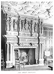 The great fireplace
 -
 Doorway


Removal and preservation 1906 edit
Most of the interior fittings were removed and installed in New Place, Shirrell Heath, Hampshire, a house designed by Edwin Lutyens specifically for this purpose. The house was commissioned by Mrs A. S. Franklyn in 1904, who had inherited Langton House from her father, a partner in the tobacco firm Franklyn, Morgan and Davy[6][7] The fittings included the State Room, the less elaborate Dining Room, and a staircase with heraldic beasts surmounting the newel posts.[3] Another fireplace from Langton House is to be found in the Assize Court in Bristol.[8]
-
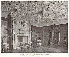 State Room or Oak Room
 -
 Dining Room
 -
 Staircase


References edit
- ^ Pilkinton, Mark Cartwright (1997). Bristol. Vol. 8. University of Toronto Press. ISBN 978-0-8020-4221-7.
- ^ a b c Latham, Charles; Tipping, H.Avray (1907). In English Homes: The Internal Character, Furniture & Adornments of Some of the Most Notable Houses of England Historically Depicted. Volume 2. London: Country Life. pp. 303–305.
- ^ a b c Pevsner, Nikolaus; LLoyd, David (1967). The Buildings of England. Hampshire and the Isle of Wight. Harmondsworth: Penguin. pp. 498–491. ISBN 0 14 071032 9.
- ^ Weaver, ,Lawrence (1913). Houses and Gardens by E.L. Lutyens. London: Country Life. pp. 75–93.
{{cite book}}: CS1 maint: multiple names: authors list (link) - ^ "Bristol Meeting, July 17-19 1906". Transactions of the Bristol and Gloucestershire Archaeological Society. 29: 25–29. 1906.
- ^ a b Rowe, Jonathan (2019). "City mansion found a New Place in a small village in Hampshire". Pressreader. Retrieved 4 February 2021.
- ^ "The Report of the Council 1891-2". Transactions of the Bristol and Gloucestershire Archaeological Society. 17: 4. 1893.
- ^ Pevsner, Nikolaus (1958). The Bildings of England. North Somerset and Bristol. Harmondsworth: Penguin. p. 415.
Category:Demolished buildings and structures in England Category:Renaissance architecture in England
Sir John Franklin Parry | |
|---|---|
 | |
| Born | 15 August 1863 |
| Died | 21 April 1926 (aged 62) Harrogate |
| Allegiance | United Kingdom |
| Service/ | Royal Navy |
| Years of service | 1877-1919 |
| Rank | Admiral |
| Office | Hydrographer of the Navy |
| Term | 1914-1919 |
Sir John Franklin Parry
Sir Archibald Day | |
|---|---|
.jpg) | |
| Born | 18 July 1899 |
| Died | 17 July 1970 (aged 70) Dover |
| Allegiance | United Kingdom |
| Service/ | Royal Navy |
| Years of service | 1914-1955 |
| Rank | Vice-admiral |
| Office | Hydrographer of the Navy |
| Term | 1950-1955 |
Sir Archibald Day (18 July 1899 - 17 July 1970) was an officer in the Royal Navy and Hydrographer of the Navy from 1950-1955. He played an important part in planning the evacuation from Dunkirk in 1940, and wrote a history of the Hydrographic Service.
Day spent two years with HMS Conway, the naval school ship, and then was at Dartmouth Naval College, but was mobilised for World War I after only one term at the age of 15. He served as cadet and midshipman in the North Sea and with HMS Welland in the Mediterranean. He was promoted to Lieutenant on 15 August 1919, and in 1920 began survey work, serving on HMS Endeavour on the north coast of Egypt.[1][2][3]: 174–175 [4] He spent the next 12 years surveying in various ships on the east coast of England, China, Malaya, and the Middle East, with two spells ashore as naval assistant.[3]: 174–175

His first commmand, from June 1932, was HMS Fitzroy on the east coast of England and Scotland. He was then with HMS Ormonde in the Persian Gulf and Cyprus. He was promoted to Commander in 1934.[3]: 174–175 From 1937 to 1940, he was Superintendent of Charts in the Hydrographic Department. He was promoted to Captain in 1940 and appointed Chief Staff Officer to the Flag Officer, Dover. He played a major part in planning the evacuation from Dunkirk in 1940.[6][7]: 77 His surveying experience on the east coast of England, with its many treacherous sandbanks and strong tides, was invaluable in this task.[8] He was Assistant Hydrographer in 1943 and 1944. This was at time when chart production was essential to the war effort, and seven milllion charts and maps were being printed each year.[8]

In November 1944, Day took over command of HMS White Bear, a yacht converted for surveying, and carrying printing equipment and staff. White Bear was then in Colombo, and took part in the Burma campaign (1944–1945) coordinating survey teams that were charting the many channels on the coast of Burma, and printing maps and charts for the assault forces.[3]: 106–107 He was awarded the DSO for this operation.[3]: 174–175 After the Japanese surrender, White Bear conducted surveys around the Malay peninsula and in Indonesia, to assist re-establishment of normal navigation.[8]
After the war, Day resumed his position as Assistant Hydrographer, and then in February 1938 took command of HMS Dalrymple, newly comissioned as a survey ship, working in the Mediterranean.[9][3]: 162 In 1950 he was appointed Hydrographer of the Navy, a post he held until 1955. As Hydrographer, Day collaborated with the Decca Navigator Company to develop electronic systems for surveying using transportable shore stations. He was a supporter of international cooperation in Hydrography and Oceanography, leading the United Kingdom Delegation to the International Hydrographic Conference held in Monaco in April 1952. He was promoted to Vice-Admiral in 1953 and made KBE in 1954.[3]: 174–175 He retired in 1955.[8]
After retirement, Day led a small team to carry out a hydrographic survey of Lake Nyasa[10] In 1956 he was appointed coordinator of the International Geophysical Year, based in Brussels, but travelling extensively to facilitate the work of scientists from many countries that were taking part.[8]
His final work was his history The Admiralty Hydrographic Service 1795-1919, which was published in 1967. The book gives a summary of the earlier part of the period, which was covered by Dawson's erlier Memoirs of Hydrography[11] and a much more detailed account of the priod from 1884-1919 with bibliographies of surveyors amd tabulations of surveys and ships by year.[3]: 1 He died on 17 July 1971 in Dover.[8]
References edit
- ^ "Sir Archibald Day". Nature. 227 (5263): 1174–1174. September 1970. doi:10.1038/2271174b0. eISSN 1476-4687. ISSN 0028-0836.
- ^ Irving,, .G. (1970). "Obituary: Vice-Admiral Sir Archibald Day, KBE, CB, DSO". The Geographical Journal. 136: 501–502. JSTOR 1795286.
{{cite journal}}: CS1 maint: extra punctuation (link) - ^ a b c d e f g h Morris, Roger O. (1995). Charts and Surveys in Peace and War: The History of the Royal Navy's Hydrographic Service, 1919-1970. H.M. Stationery Office. ISBN 978-0-11-772456-3.
- ^ "Archibald Day". Dreadnought Project.
- ^ Southern, R.M. (1948). Admiralty Manual of Hydrographic Surveying (2 ed.). H.M. Stationery Office. OCLC 1110309666.
- ^ "Vice-Admiral Sir ARCHIBALD DAY, CB, DSO". Polar Record. 15: 554–555. 1971.
- ^ Robert Jackson (26 July 2012). Dunkirk: The British Evacuation, 1940. Hachette UK. ISBN 978-1-78022-452-7.
- ^ a b c d e f "Obituary, Vice Admiral Sir Archibald Day". International Hydrographic Review. 48 (1): 7–9. 1971.
- ^ Bailey, R.T. (1960). "Hydrographic Survey of Lake Nyasa (1955 to 1959)". The International Hydrographic Review. 37 (1): 43–55.
- ^ Dawson, Llewellyn Styles (1885). Memoirs of hydrography, including brief biographies of the principal officers who have served in H.M. Naval Surveying Service between the years 1750 and 1885. Eastbourne: Henry W. Keay. p. 70. Part 1. - 1750 to 1830; Part 2. - 1830-1885.
Bibliography edit
- Day, Archibald (1955). "Hydrographic Surveys: The Purpose and the Choice of Scale". The International Hydrographic Review. 32 (1): 9–24.
- —— (1956). "Lake Nyasa hydrographic survey talk to the Nyasaland Society on 9 March 1956". The Nyasaland Journal. 9 (2): 57–64. JSTOR 29545777.
- —— (1957). "Some Organizational Aspects of the International Geophysical Year". The Journal of Navigation. 10 (3): 249–253. doi:10.1017/S0373463300016866.
- —— (1967). The Admiralty Hydrographic Service, 1795-1919. H.M. Stationery Office. OCLC 1082894797.
Sea also edit
External Links edit
Warning: Default sort key "Day,Archibald" overrides earlier default sort key "ONeill, B. H. St. John". Category:1899 births Category:1970 deaths Category:British hydrographers Category:Hydrographers of the Royal Navy Category:Royal Navy admirals
The Scottish Geographical Magazine was published by the Royal Scottish Geographical Society from 1885-1998. From 1999 it continued as the Scotish Geographical Journal. Volumes (year) available at the Internet Archive include:
- 1 (1885) 2 (1886) 3 (1887) 4 (1888) 5 (1889) 6 (1890) 7 (1891) 8 (1892) 9 (1893) 10 (1894)
- 11 (1895) 12 (1896) 13 (1897) 14 (1898) 15 (1899) 16 (1900) 17 (1901) 18 (1902) 19 (1903) 20 (1904)
- 21 (1905) 22 (1906) 23 (1907) 24 (1908) 25 (1909) 26 (1910) 27 (1911) 28 (1912) 29 (1913) 30 (1914)
- 31 (1915) 32 (1916) 33 (1917) 34 (1918) 35 (1919) 36 (1920)
- 38 (1922)
.jpg)
Charles Gepp Robinson (3 December 1805 - 31 October 1875) was a Royal Navy Officer and hydrographic surveyor particularly noted for his survey work in the west of Scotland.
Robinson was born at Appledore House in Devon. He joined the Navy on 13 May 1819 on board HMS Hasty in the North Sea.[1] [2][3] His first overseas posting was with William Fitzwilliam Owen in HMS Leven from 1821-1826, surveying the east coast of Africa. The survey cost the lives of more than half of the crew due to tropical diseases, and Robinson was one of the few officers to return alive to England.[2][4] He was promoted to Lieutenant in 1826, and returned to Africa with Owen in HMS Eden on a mission to establish a settlement at Fernando Po, which was believed to be healthier than other parts of West Africa. This turned out not to be true, and mortality due to fever was as high as on the previous trip, but again Robinson was one of the few to survive, as did Owen and his family who accompanied him.[2][5]: 107–135 During his time in Africa, Robinson was active in pursuing slaving ships, capturing three of them.[2]


From March 1829 to April 1835 he served in various ships as assistant to Henry Mangles Denham surveying the coasts of Wales and western England. He then took command of the Welsh survey after which he moved to Scotland. He was promoted to Commander in 1838, was for a short while in command of HMS Gleaner, then took command of the paddle steamer HMS Shearwater until she was transferred to famine relief work in Ireland in 1847.[6] Robinson's surveys of Scotland covered a large part of the the west coast from the Solway Firth to Oban.[7] While surveying in the Clyde in 1844, two of Shearwater's midshipmen on a pleasure sail were drowned when a squall capsized their boat. A memorial was raised to them by Robinson and the officers of Shearwater at the north end of Great Cumbrae Island.[8] Robinson was promoted to post-captain in 1846, and continued in the surveying service until 1854.
Robinson was apponted to HMS Ceylon in the Mediterranean in 1854, and took part in cable-laying operations.[2] In 1860 he was recorded as living in Oban. He had one daughter, Julia Isabella.[9] He was promoted to rear-admiral in 1864 and to vice-admiral in 1871. He died on 31 October 1875 [3]
References edit
- ^ O'Byrne, William R. (1849). A naval biographical dictionary: comprising the life and services of every living officer in Her Majesty's navy, from the rank of admiral of the fleet to that of lieutenant, inclusive. London: John Murray. p. 991.
- ^ a b c d e Dawson, Llewellyn Styles (1885). Memoirs of hydrography, including brief biographies of the principal officers who have served in H.M. Naval Surveying Service between the years 1750 and 1885. Part 2. - 1830-1885. Eastbourne: Henry W. Keay. p. 70.
- ^ a b "Admiral Charles Gepp Robinson Obituary". Annual Register. 117: 149. 1875.
- ^ Morris, Roger (January 1996). "200 YEARS OF ADMIRALTY CHARTS AND SURVEYS". The Mariner's Mirror. 82 (4): 420–435. doi:10.1080/00253359.1996.10656616. eISSN 2049-680X. ISSN 0025-3359.
- ^ Ritchie, George Stephen (1967). The Admiralty Chart: British Naval Hydrography in the Nineteenth Century. Hollis & Carter. OCLC 1082888087.
- ^ Rice, Tony (1986). British Oceanographic Vessels 1800-1950. London: The Ray Society. p. 135. ISBN 0 903874 19 9.
- ^ Robinson, Adrian Henry Wardle (1962). Marine Cartography in Britain: A History of the Sea Chart to 1855. With a Foreword by Sir John Edgell. Leicester University Press. pp. 198–199. OCLC 62431872.
- ^ Hugh MacDonald (1860). Days at the Coast:: A Series of Sketches Descriptive of the Frith [sic] of Clyde- Its Watering-places, Its Scenery, and Its Associations. John Cameron, Renfield Street. pp. 233–234. OCLC 1071025556.
- ^ Dod's Peerage, Baronetage and Knightage of Great Britain and Ireland for 1866, Including All the Titled Classes (26 ed.). Whittaker. 1866. p. 159. OCLC 28172148.
External links edit
Warning: Default sort key "Robinson,Charles Gepp" overrides earlier default sort key "Day,Archibald". Category:Royal Navy officers Category:1805 births Category:1875 deaths