Talk:Lower Town
| This article is rated Start-class on Wikipedia's content assessment scale. It is of interest to the following WikiProjects: | |||||||||||||||||||||||||||
| |||||||||||||||||||||||||||


poorer edit
Lower town is basically one of the poorer neighborhoods of Ottawa, is there any way to mention this without it being edited out? Dan Carkner 04:49, 2 November 2005 (UTC)
-- you could find a link to census data backing it up Alaney2k 18:54, 5 July 2007 (UTC)
recent edit re:lanes edit
"The number of lanes has since been reduced, and there is currently extensive work in returning the street to its former glory." Since when..? Last time I looked it was still the same and they were maybe planning on putting some planter pots to "beautify"..? Dan Carkner 12:36, 27 March 2006 (UTC)
External links modified edit
Hello fellow Wikipedians,
I have just modified one external link on Lower Town. Please take a moment to review my edit. If you have any questions, or need the bot to ignore the links, or the page altogether, please visit this simple FaQ for additional information. I made the following changes:
- Added archive https://web.archive.org/web/20130824234222/http://capitalneighbourhoods.ca/english/lowertown/story-348.aspx to http://capitalneighbourhoods.ca/english/lowertown/story-348.aspx
When you have finished reviewing my changes, you may follow the instructions on the template below to fix any issues with the URLs.
This message was posted before February 2018. After February 2018, "External links modified" talk page sections are no longer generated or monitored by InternetArchiveBot. No special action is required regarding these talk page notices, other than regular verification using the archive tool instructions below. Editors have permission to delete these "External links modified" talk page sections if they want to de-clutter talk pages, but see the RfC before doing mass systematic removals. This message is updated dynamically through the template {{source check}} (last update: 18 January 2022).
- If you have discovered URLs which were erroneously considered dead by the bot, you can report them with this tool.
- If you found an error with any archives or the URLs themselves, you can fix them with this tool.
Cheers.—InternetArchiveBot (Report bug) 17:14, 7 January 2018 (UTC)
Neighbourhood boundary modifications edit
Hi all,
Earlier tonight I made a change to Line 64 & 128, specifically to the Lowertown neighbourhood boundaries using a reliable source containing verifiable evidence from Ottawa's OpenData Portal.
The changes were immediately reverted: here and here, respectively, with a duplicate comments stating "let's use the community association boundaries. ONS makes up their own boundaries for statistical purposes, and don't match reality."
Can we come to a consensus regarding which boundaries should be used and why? (ie: ONS, community assoc., other?) Also I would like to see sources for the aforementioned community association boundaries and what is meant by "reality" in the context of the edit comments.
In my defence, ONS Neighbourhood Boundaries are an easily accessible source of information from the city itself, which the city can update readily, and that anybody and everybody can refer to quite easily at any given time. It is the data I use to submit additions or revisions to Google Maps, 99% of which are accepted almost immediately. Furthermore each respective year of city census data is compiled and analyzed using ONS data and ONS Neighbourhood Boundaries, so if this source is treated as a "master record" of sorts for all types of government agencies, companies, and individuals, why is it not sufficient for Wikipedia?
Don't mean to cause any drama here, but I've been very careful in studying Wikipedia guidelines before making edits and I'd like to know where I went wrong here...
If there's no discussion on this subject for a reasonable period of time, say a week, I will revert the changes back to my original edits, and cite this discussion subject in the comments.
Looking forward to continuing to add and update valuable information to neighbourhood pages across the city on here and across the web!
--Redivivus613 (talk) 03:57, 20 April 2019 (UTC)
- Hi, my issue with the ONS is that the boundaries they use were not done in consultation with the actual neighbourhoods themselves, or at least there is no evidence of it. Community Associations are the actual "governing bodies" (for lack of a better term) of neighbourhoods, and would therefore have a better idea of what the boundaries of neighbourhoods are. The ONS often lumps more than one neighbourhood together, breaks them up, creates new names for neighbourhoods that people don't actually use, or in one case, mis-spells the name of a neighbourhood. The city might use it for statistical purposes, but for all intents and purposes, they don't appear on maps (except for Google), and aren't used by the public. When you ask someone what neighbourhood they live in, they're not going to cite what their ONS neighbourhood is. -- Earl Andrew - talk 04:39, 20 April 2019 (UTC)
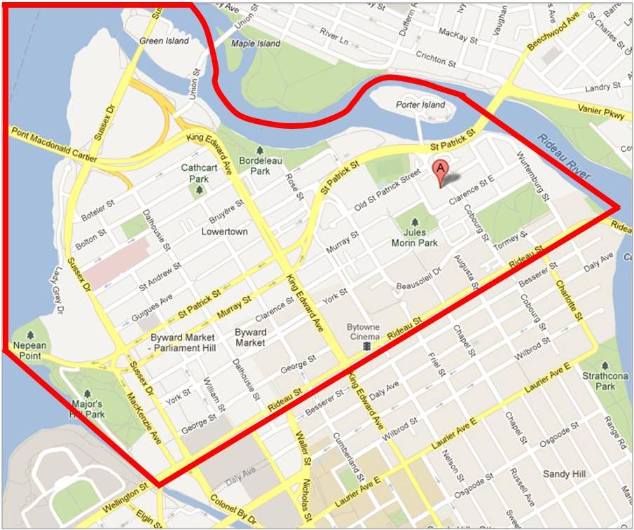
- Thanks for your response, I completely understand. Unfortunately I unintentionally missed the web cite[1] with the information used for the articles original stated boundaries prior to my edit. Upon further examination, it's clear that the community association states these boundaries under the image[2] particularly "the Ottawa neighbourhood bounded by Rideau Street to the south, the Ottawa River to the north, the Rideau Canal to the west, and the Rideau River to the east" are in fact the area in which they've mandated themselves to represent resident interests, and not the actual neighbourhood boundaries as per any official source or actual "governing body". Community-led resources such as food banks can also dictate such boundaries and quite often they also extend into neighbourhoods one wouldn't expect them too, or conversely, not extend far enough into neighbourhoods they've mandated themselves to serve with their resources, etc. (Very much like ONS and other geographical data gathererers found on OpenData Ottawa). That being said, I am perfectly fine with my edits remaining out and not using ONS geographical boundary data in this article, but I believe the article should be better edited to reflect the facts, that "area residents and community associations typically consider the Lower Town area to be bounded by..." and going forward as I add community resources to the article, it may be necessary to have an entire category for community associations such as the ones I've mentioned here. Please let me know how you'd like to proceed! Thanks again for your help! Redivivus613 (talk) 05:11, 20 April 2019 (UTC)
- That's the thing about neighbourhoods, they rarely have any defined boundaries outside of what various community organizations say they are. I think if we want to be extremely prudent, if two sources differ, we could always mention both. Anyway, please go ahead and clean up the article. I will monitor it, and will let you know if I find anything else contentious. Cheers & happy editing. -- Earl Andrew - talk 05:25, 20 April 2019 (UTC)