Talk:Control of cities during the Syrian civil war/Archive 34
| This is an archive of past discussions. Do not edit the contents of this page. If you wish to start a new discussion or revive an old one, please do so on the current talk page. |
| Archive 30 | ← | Archive 32 | Archive 33 | Archive 34 | Archive 35 | Archive 36 | → | Archive 40 |
Forgotten Military Sites (Pre-2013)
While this map is getting better and better, it still lacks some precision. For instance, many military sites/checkpoints mentioned in Wikipedia Syrian Civil War articles, are missing here. The most striking example is the Khan Al Assal Police Academy where a huge battle had taken place that ended with a rebel victory. You can confirm the presence of such sites by seeing them deep inside the affiliated territory using Wikimapia etc. Cheers ChrissCh94 (talk) 02:47, 29 November 2014 (UTC)
- There is also the Brigade 66 in Eastern Hamah Desert where it was besieged for some time by the rebels before the siege was lifted in late 2013 by the SAA. And if someone has some free time why not add the SAA bases in Latakia? Some of them were presumably bombed by Israel. ChrissCh94 (talk) 02:57, 29 November 2014 (UTC)
- According to data from two the pro opposition maps herehere area where located the Army Base of Brigade 66 under control by army. So i add this base on map and noted her as under control by army. Hanibal911 (talk) 13:20, 30 November 2014 (UTC)
- Yes I know it's under regime control all I said it WAS besieged in late 2013 before the SAA attacked in Eastern Hamah and captured villages there (in September 2013). So I perfectly agree with you. But please also add the Khan-Al-Assal Police Academy in Aleppo it's an important military site that saw deadly battles between the 2 sides and lot's of casualties. ChrissCh94 (talk) 18:25, 1 December 2014 (UTC)
- ChrissCh94 Can you show me on the map where this object located. And I add it on map because I have sources which can confirm my actions. Hanibal911 (talk) 19:59, 1 December 2014 (UTC)
- Also i think that we need put on map the Air Defense Base (Brigade 599) located in area which under control of the regime troops. And this confrirmed many pro opposition and pro government maps.hereherehereherehereherehere Hanibal911 (talk) 20:27, 1 December 2014 (UTC)
- Alright man I agree, add them if they are deep into regime territory. Here is the rebel controlled Police School/Academy I was talking about: here
- The Wikipedia article about Khan El Assal battle proves it's rebel held (kinda obvious though)
- You could also add the 2 army bases in the area they are deep into rebel areas so they are controlled by those rebels: here
- and here
- ChrissCh94 (talk) 21:09, 1 December 2014 (UTC)
- There is also this Radar Base which was taken in 2012 by the rebels then in 2014 by ISIS. I concluded that it is now controlled by ISIS and not the rebels because it is in deep ISIS territory: here ChrissCh94 (talk) 21:14, 1 December 2014 (UTC)
- Also i think that we need put on map the Air Defense Base (Brigade 599) located in area which under control of the regime troops. And this confrirmed many pro opposition and pro government maps.hereherehereherehereherehere Hanibal911 (talk) 20:27, 1 December 2014 (UTC)
- ChrissCh94 Can you show me on the map where this object located. And I add it on map because I have sources which can confirm my actions. Hanibal911 (talk) 19:59, 1 December 2014 (UTC)
- Yes I know it's under regime control all I said it WAS besieged in late 2013 before the SAA attacked in Eastern Hamah and captured villages there (in September 2013). So I perfectly agree with you. But please also add the Khan-Al-Assal Police Academy in Aleppo it's an important military site that saw deadly battles between the 2 sides and lot's of casualties. ChrissCh94 (talk) 18:25, 1 December 2014 (UTC)
- According to data from two the pro opposition maps herehere area where located the Army Base of Brigade 66 under control by army. So i add this base on map and noted her as under control by army. Hanibal911 (talk) 13:20, 30 November 2014 (UTC)
- ChrissCh94But in issue this Radar Base (Al Sha`allah) I'm not so sure of this! Because this Radar Base is located near the villages which are under the control of the some moderate rebel groups. And pro opposition map show that this Radar Base noe under cotnrol by rebels.here So we need more data before adding it to the map. Hanibal911 (talk) 11:45, 2 December 2014 (UTC)
- Yes you're right concerning this one. Feel free to add any other SAA bases/regiments deep inside Regime territory ChrissCh94 (talk) 18:24, 2 December 2014 (UTC)
- I also added some military facilities that are in areas that are under the control of the army on the basis of data from the pro-opposition map.here And I also want add some military facilities which located in areas which under the control of insurgents and militants ISIS according to data from pro-government maps. Hanibal911 (talk) 13:09, 3 December 2014 (UTC)
- Alright man great work! Keep me up to date on what you're adding so I can help! ChrissCh94 (talk) 17:42, 3 December 2014 (UTC)
- ChrissCh94 Thank you for your praise in my adress! I as well as you try in order our map was more detailed and if you have other suggestions about objects that we can add on the map you say me and I'll help you. Hanibal911 (talk) 08:04, 5 December 2014 (UTC)
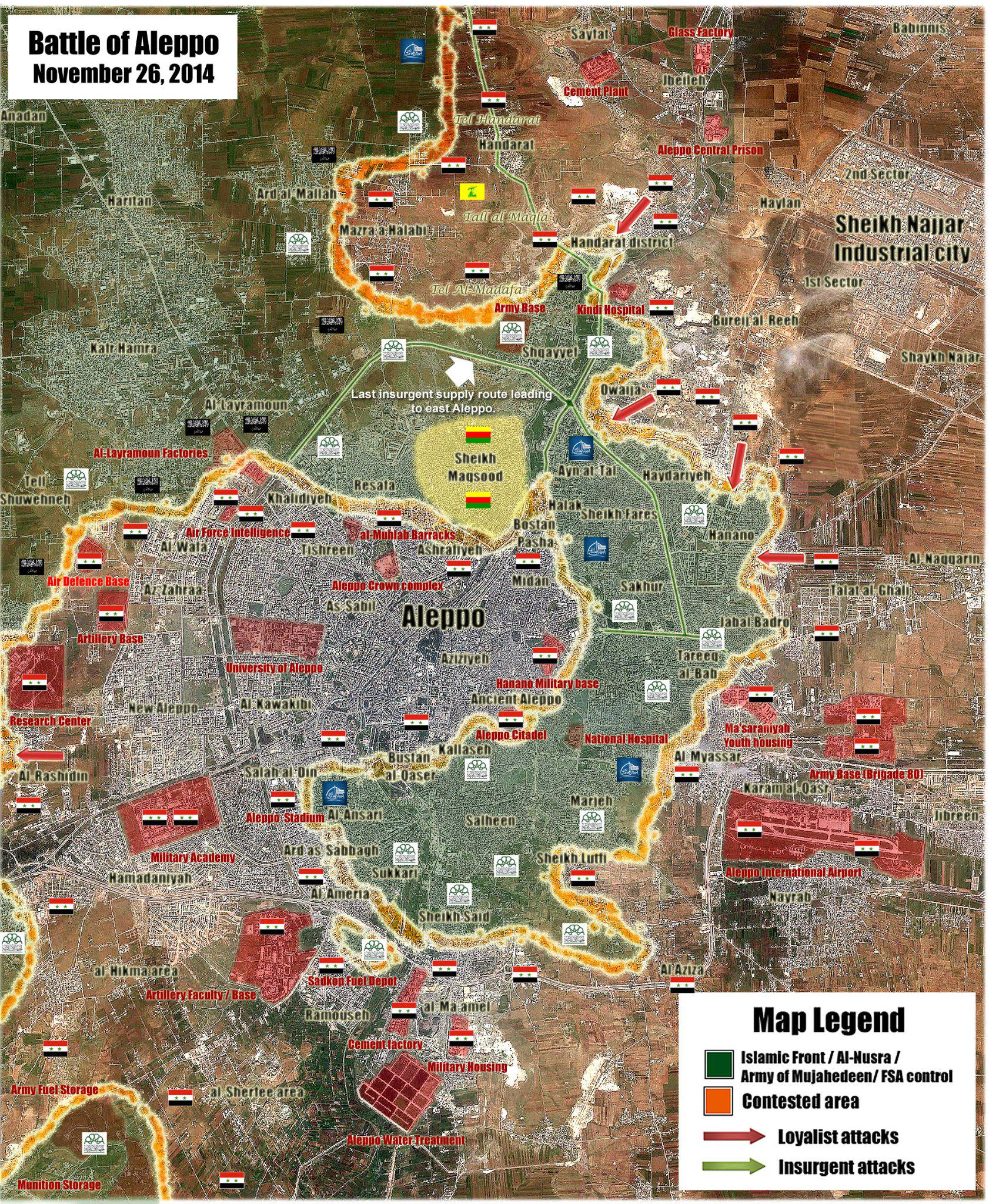
- ChrissCh94 The I think would be the best solution add military installations located in the areas which controlled by one or another party to the conflict.Here is a list of military objects which are likely under control the moderate rebels: Military Training BaseAir defense BattalionMilitary College and some military objects in Dara province which located in area under control by rebels. Here list of military objects which are likely under control the army:Army Base Brigade 552al-Muhlab BarracksAir Defense BaseArmy BaseAir Defense AcademyArmy Artillery Base and some military base in Tartus in province which fully under control by army. Hanibal911 (talk) 12:20, 5 December 2014 (UTC)
- ChrissCh94 Also here list of military objects which are likely under control the Kurdish: Army Bas which is located near of Kurdish village Tell Beydar Air Defence Base Also here list of military objects which are likely under control the ISIS: Qarah Burghul DaghArmy Storage BaseAl Taurah Airfield Hanibal911 (talk) 12:43, 5 December 2014 (UTC)
- Agreed for all the above except those 2 Kurdish sites since they come in areas of shared control between pro-gov forces and PYD. All the remaining sites have clear owners. Thanks alot mate! If you got some time check the list of military installations near Homs city. Lots of military brigades there! Cheers ChrissCh94 (talk) 18:20, 5 December 2014 (UTC)
- ChrissCh94 Also here list of military objects which are likely under control the Kurdish: Army Bas which is located near of Kurdish village Tell Beydar Air Defence Base Also here list of military objects which are likely under control the ISIS: Qarah Burghul DaghArmy Storage BaseAl Taurah Airfield Hanibal911 (talk) 12:43, 5 December 2014 (UTC)
- ChrissCh94 The I think would be the best solution add military installations located in the areas which controlled by one or another party to the conflict.Here is a list of military objects which are likely under control the moderate rebels: Military Training BaseAir defense BattalionMilitary College and some military objects in Dara province which located in area under control by rebels. Here list of military objects which are likely under control the army:Army Base Brigade 552al-Muhlab BarracksAir Defense BaseArmy BaseAir Defense AcademyArmy Artillery Base and some military base in Tartus in province which fully under control by army. Hanibal911 (talk) 12:20, 5 December 2014 (UTC)
- ChrissCh94 Thank you for your praise in my adress! I as well as you try in order our map was more detailed and if you have other suggestions about objects that we can add on the map you say me and I'll help you. Hanibal911 (talk) 08:04, 5 December 2014 (UTC)
- Alright man great work! Keep me up to date on what you're adding so I can help! ChrissCh94 (talk) 17:42, 3 December 2014 (UTC)
Talbise, Homs
From SOHR Talbise is contested [1].79.54.139.69 (talk) 15:57, 6 December 2014 (UTC)
- Likely clashes in the western outskirts of the city. Hanibal911 (talk) 17:10, 6 December 2014 (UTC)
Highway between Homs - Deir Ez Zor
Hey guys someone have there is data from reliable source about who controls it is highway. Which passes from the city of Homs through the city of Palmyra to the city of Deir Ez Zor. Because i found map which show that this highway still under control by army.here Hanibal911 (talk) 14:22, 3 December 2014 (UTC)
Articles on Al-Masdar frequently imply that this road is still controlled by the government. Several of their reports about fighting in Eastern Homs have mentioned the importance of the supply route to Deir Ez Zour.
- Haven't seen a source specifically mention to two major transit towns al-Sulah and Kabajeb in months. Is the SAA supplying via Highway 7? Or airdrops like Nubl and al Zahraa? Pieter v map shows the area as IS held. Unclear. Boredwhytekid (talk) 15:41, 3 December 2014 (UTC)
This highway is controlled by the army since October 2013 https://www.youtube.com/watch?v=vudzW9u0BPA but no with extensive military presence ISIS cross this zone many times in Direction to Raqqah. --Pototo1 (talk) 15:54, 3 December 2014 (UTC)
- Bun other map show that this highway still under control by army.here Since, unlike Shia towns Nublo and Al Zahra the city of Deir Ez Zor too large and strategically important for government and would not be possible to maintain this city using only the supply of arms and ammunition on air. Also would be very difficult to supply fuel and heavy weapons into the city. Also this would be very difficult to supply fuel and heavy weapons into the city for the to continue fights against ISIS. Hanibal911 (talk) 16:33, 3 December 2014 (UTC)
- Also here map which showed that ISIS fighters just attack this area where passes this highway but not said that now ISIS fully control this area. Hanibal911 (talk) 16:39, 3 December 2014 (UTC)
Very true. Doubtful that either side has complete control or set positions Boredwhytekid (talk) 17:07, 3 December 2014 (UTC)
My guess would be that the Army doesn't actually control the road 24/7 but that they occasionally use it to send in a very well protected supply convoy.
The Army can resupply Deir Ez Zor every the time using this road with tons of munitions, but it's not possible permanent presence in this way it's a desert, many areas in Black on these maps just need to be writhe the ISIS in Syria got too low manpower for controlled all this black territory --Pototo1 (talk) 20:26, 3 December 2014 (UTC)
- So maybe that the some villages (Kabajeb and Al-Shulah) which located on this highway need marked in red with black circles around. According this mapherehere Hanibal911 (talk) 20:49, 3 December 2014 (UTC)
Eh. I'd say more sources needed. The SAA probably goes down the road with well protected supply convoys to supply Deir el Zor, but we don't have any indication that they actually have a permanent presence/occupying force in any towns that far East of as-Sukhnah Boredwhytekid (talk) 20:57, 3 December 2014 (UTC)
- Probably you're right. But we know that, according to pro opposition map that the village of Bayt Alyawi Zubaylan which located near highway and a village of Nujayb which located on this highway for now under army control. So I suggest for now add those villages to the map. Hanibal911 (talk) 21:29, 3 December 2014 (UTC)
Is Nujayb on the desyracuse map? As goes Bayt Alyawi Zubaylan - I mean, yea, go ahead and add it if you want, but, why? It's 2 random buildings right next to Bayt Hassun al Ahmad, which is already on our map. That's my take on it. But, no objections if you think it's necessary. The one thing that makes me uneasy about it though, is that desyracuse is the lone source. I mean, look at the Nawa area on his map - it's so outdated - THAT is precisely why I'm always against using these amateur maps as lone sources. Boredwhytekid (talk) 13:52, 4 December 2014 (UTC)
- Is anything coming of the "Presence" icons suggestions? This would be a perfect place to use them - between Kabajeb (IS) and Kasrat Faraj (SAA) we should mark both IS and SAA presence Boredwhytekid (talk) 14:37, 4 December 2014 (UTC)
- Boredwhytekid Here pro opposition map show that part of highway which goimg from Deir ez Zor still contolled by army.here But who controls this highway further still unknown. Hanibal911 (talk) 19:43, 6 December 2014 (UTC)
Rebel presence in Eastern Qalamoun
I suggest adding the dotted square thing, that you guys added in Western Qalamoun, in the Eastern Qalamoun region. It's fair considering both regions contain a relatively high number of rebels waging a guerrilla war against static SAA positions. Rebels can also travel easily between those 2 regions so it only makes sense adding that new dotted symbol in Eastern Qalamoun ChrissCh94 (talk) 23:10, 6 December 2014 (UTC)
- I agree with this suggestion. There are also 2 black and 2 red ones that I think should be added. Red one between Kasrat Faraj and Kabajeb to show that the SAA runs supplies to Deir el Zor. Red one between Rasm Abu Alba and Al-Hamam to show the same but to Aleppo. Black one between T2 pumping station and Jabal al Ghurab. And a black one between Jubb al-Abyad and Qastal al Ghazi to show the IS presence between Raqqa province and their holdings in eastern Homs/Hama provinces. I think those, combined with the 2 green ones for Eastern/Western Qalamoun, are the spots of biggest need for this icon. And hopefully we can avoid argument seeing as how we'd be adding 2 for each side. Boredwhytekid (talk) 23:56, 6 December 2014 (UTC)
Hasakah province
According to Almasdar news villages Al-Siyyaha and Touq Al-Malah in west Al-Hasakah were taken over by SAA from ISIS. I know there is a discussion about the neutral reliability in Almasdar... But anyway I can´t find the villages on the map, so can someone please put them out.Rhocagil (talk) 02:25, 7 December 2014 (UTC)
- But for now about this reported only government or pro government sources.Electronic ResistanceSyria 24Islamic Iinvitation TurkeySyrian Perspective Hanibal911 (talk) 13:18, 7 December 2014 (UTC)
Yes, but Hanibal you are good with the map, could you fid the villages and put them out. red - black - contested, I don´t know? but still put them them out there. :) Rhocagil (talk) 13:41, 7 December 2014 (UTC)
ISIS offensivein and Army counter-offensivein in Al Mari'iyah
Opp.s.: #Islamic_State has captured Al-Mari'iyah area and clashes with #SAA in Jaffra village, located SE of #Deir_Ezzor Airport. #Syria source: https://twitter.com/PetoLucem/status/540267300776333313 — Preceding unsigned comment added by Herrhorace (talk • contribs) 23:57, 3 December 2014 (UTC)
- Opposition Sources are not reliable to report ISIS gains. Peto Lucem is pro-gov, but he is quoting Opp-sources. XJ-0461 v2 (talk) 00:11, 4 December 2014 (UTC)
- No need in debate because SOHR clear said that 19 members from the regime forces and NDF died when an IS militant blew himself up in a booby- trapped vehicle yesterday night at al- Masemekeh Building located in the vicinity of the airbase of Deir Ezzor, and due to the clashes followed the suicide bombing in Hwayjet al- Mre’eyyi area near the airbase, coincided with IS violent shelling on the regime held village of al- Jafra and its positions inside the airbase.SOHR So that SOHR clear saud that the village Jafra still under control by army and ISIS only shelling of this village. Hanibal911 (talk) 08:49, 4 December 2014 (UTC)
- According to this link http://syriadirect.org/rss/1729-syria-direct-news-update-12-4-14 Jaffra has been conquered by ISIS, and I quote:
- No need in debate because SOHR clear said that 19 members from the regime forces and NDF died when an IS militant blew himself up in a booby- trapped vehicle yesterday night at al- Masemekeh Building located in the vicinity of the airbase of Deir Ezzor, and due to the clashes followed the suicide bombing in Hwayjet al- Mre’eyyi area near the airbase, coincided with IS violent shelling on the regime held village of al- Jafra and its positions inside the airbase.SOHR So that SOHR clear saud that the village Jafra still under control by army and ISIS only shelling of this village. Hanibal911 (talk) 08:49, 4 December 2014 (UTC)
"“Jafra is a town that sits opposite the airport on the other side of a main road connecting Deir e-Zor city to its eastern countryside,” a citizen journalist from Deir e-Zor city told Syria Direct Thursday, confirming the fall of the town from regime control to the Islamic State." Hence changes must be made in this map and in the Deir-Ez-Zor map, large offensive from ISIS from southeast on the march. Gomes89 (talk) 14:49, 4 December 2014 (UTC)
Confirmed by reliable sources, Al Meri'iyah and Jafrah under IS control, who also attacks in Saqr Island to sorround the Airport. https://twitter.com/EjmAlrai/status/540547861826764802 Fab8405 (talk) 16:56, 4 December 2014 (UTC)
- Al Meri'iyah teken by ISIS but not Jafrah. ISIS just gained control on new areas in it after violent clashes but clashes still ongoing.SOHRSOHR Hanibal911 (talk) 22:08, 4 December 2014 (UTC)
- I'd say Mari'iyah to ISIS-held and Jafra contested. ChrissCh94 (talk) 22:20, 4 December 2014 (UTC)
- I support this. At least the eastern part of Jafra contested. Problem we will have in the future is, however, how will we know if the SAA launches a counterattack? SOHR has not been helpful in reporting SAA gains in Deir-Ez-Zor. XJ-0461 v2 (talk) 23:03, 4 December 2014 (UTC)
- I'd say Mari'iyah to ISIS-held and Jafra contested. ChrissCh94 (talk) 22:20, 4 December 2014 (UTC)
Detailed report from Al Masdar [2]: basically Al-Mari’ayyi contested Jafra in SAA control. Fighting ongoing in several areas.95.244.159.103 (talk) 22:21, 4 December 2014 (UTC)
SOHR is reporting normally in Deir Ez-Zor. So, Elijah is one of the most reliable sources of Syria, so Mariyah IS held, and Jafra contested on the map. Someone should edit the map. — Preceding unsigned comment added by 179.180.185.190 (talk) 23:47, 4 December 2014 (UTC)
- SOHR informed that the IS took control al-Jafra village between Hweja Saker and the military airport and reached the gates of the airport after violent clashes against regime forces.source Hanibal911 (talk) 10:42, 5 December 2014 (UTC)
- The reliable source reported that Army during the counter-offensive recovered Al Mari'iyah from IS and regain control of the Deir-ezzour airport perimeter from IS.Elijah J. Magnier Hanibal911 (talk) 11:43, 5 December 2014 (UTC)
- He also implied that ISIS is not in fact in Jaffra or has been repelled here https://twitter.com/EjmAlrai/status/540979262506143744. Should I change the map? XJ-0461 v2 (talk) 22:22, 5 December 2014 (UTC)
- SOHR reported about clashes between IS and the regime forces on the mountain overlooking Deir Ezzor. In this mountain there are a radar and an artillery battery and separates the airbase and the regime - held neighborhood of Deir Ezzor. Information reported that IS militants could control some positions and seize heavy machine guns and artillery, while the clashes resulted in the death of some regime elements.SOHR And ISIS took control on the missiles battalion to northeast of the Airport.SOHR But later SOHR informed that the IS advances in area the airport stopped after heavy shelling and bombardment by regime forces. Also ISIS pulled back from areas in the mount overlooking Deir ez Zor where located a radar and artillery battery after it was exposed heavy bombardment a regime forces.SOHRSOHRElijah J. Magnier Hanibal911 (talk) 11:27, 6 December 2014 (UTC)
- Does this mean that the SAA retook the radar and artillery battalion? XJ-0461 v2 (talk) 17:41, 6 December 2014 (UTC)
- SOHR reported about clashes between IS and the regime forces on the mountain overlooking Deir Ezzor. In this mountain there are a radar and an artillery battery and separates the airbase and the regime - held neighborhood of Deir Ezzor. Information reported that IS militants could control some positions and seize heavy machine guns and artillery, while the clashes resulted in the death of some regime elements.SOHR And ISIS took control on the missiles battalion to northeast of the Airport.SOHR But later SOHR informed that the IS advances in area the airport stopped after heavy shelling and bombardment by regime forces. Also ISIS pulled back from areas in the mount overlooking Deir ez Zor where located a radar and artillery battery after it was exposed heavy bombardment a regime forces.SOHRSOHRElijah J. Magnier Hanibal911 (talk) 11:27, 6 December 2014 (UTC)
- He also implied that ISIS is not in fact in Jaffra or has been repelled here https://twitter.com/EjmAlrai/status/540979262506143744. Should I change the map? XJ-0461 v2 (talk) 22:22, 5 December 2014 (UTC)
- The reliable source reported that Army during the counter-offensive recovered Al Mari'iyah from IS and regain control of the Deir-ezzour airport perimeter from IS.Elijah J. Magnier Hanibal911 (talk) 11:43, 5 December 2014 (UTC)
Why did Al Meri'iyah turn back red? I know yesterday Magnier said this, but was before the late night- today morning offensive...if they are at the airport entrance, Al Mery'iyah is obviously black. Fab8405 (talk) 18:19, 6 December 2014 (UTC)
- Two things. First, I need a source for the fact that ISIS is at the airport entrance. Latest SOHR post said they were repelled from the perimeter and out of the mountains. Second, you cannot assume that since they are at the entrance, then Al Mery'iyah is black. That is original research. You need a source that says that ISIS has recaptured it. XJ-0461 v2 (talk) 18:51, 6 December 2014 (UTC)
From Elijah J Magnier, SyAF attacks IS positions in Al Meri'iyah and Sakr Island, so at least Al Meri'iyah is contested. https://twitter.com/EjmAlrai/status/541605045314543617 Fab8405 (talk) 14:52, 7 December 2014 (UTC)
Do Something for stop the systematic Boredwhytekid vandalism in Qalamoun Area.
The user Boredwhytekid is doing systematic vandalism in Qalamoun area he or other pro Insurgent editor are drawing there green circles who no exit or he just is not got a good documentation about that (Is irrelevant who made these green circles because are incorrect anyway) -
- The Syrian Army in April 2014 took the control from al-Jebbah Here is the Official Syrian TV Report this is well know for ALL!
- In April too the Syrian Army captured Ras Maara Here is the Diadly Star source (A lot more exist just need to used Google) SINCE TODAY I NO FOUND A SINCE SOURCE TALKING ABOUT INSURGENT PRESENCE AL-JEBBAH OR RAS MARAA AREA
Boredwhytekid just no have sources for draw or keep these green circles there because that no exit very simple
- No sources no changes - those circles were there, you took them down without a source. And now you say, no sources no changes. There is no point talking to you. Those circles went up mid-October, based on this article, that specifies Jebbah AND the road/area between there and Assal al-Ward. You have not posted a single source negating this. Boredwhytekid (talk) 16:57, 4 December 2014 (UTC)
those circles present the Jurud area,the mountain area near to the towns,because these moutains are under rebel control,the battlefield in the Qalamoun is different,than the rest of Syria.Alhanuty (talk) 17:04, 4 December 2014 (UTC)
- Agree! In this case semicircles are needed that would show that the rebels are still in the area and sometimes there are clashes in the area of these cities. Hanibal911 (talk) 17:34, 4 December 2014 (UTC)
- This Field report Al Alam TV is in November from 2014 is the West from Assal Al Ward https://www.youtube.com/watch?v=K8AwcfSb3No how you can see in Assal Al Ward is not besieged on the West and I Let the Kid keep his green semi circle there.
The question is simple =
Are these towns blocked / Besiege in all the west sector by the Insurgents ?
No it's not.
If you put semi circles in these towns in Qalamoun you should need to put green circles in ALL Greens Towns in Homs province, in ALL Green towns of North of Idlib province and all green towns of North of Latakia, in all Greens tonws because clashed are usual there with army troops.
The Insurgents presence there is low they are no able there to made important actions against the Army basically just low scale armed activities - The Situation is very different in Jordan / Israeli border.
Minor clash is not enough evidence to make a entire west side for these towns under permanent siege In Qalamoun region the Army have a clear military superiority over the Insurgents so how can the Insurgents in this way made a permanent siegue in the West side of these towns ?
Just look Hirak town in Daraa in fron is the Brigade 52 base we should put Hirak blocked in the west by the Army too?
I'm against to put these greens circles in Qalamoun based on
- Nothing sources or too vague most sources talking only Assal Al Ward (Zone when the Green Circle are not removed)
- The solid Army control in Al-Jebbah and Ras al-Maraa is well know since April 2014.
- The Army got a very extensive military superiority against the Insurgents in Qalamoun
- The only zones when I have information from Insurgent activity is Assal al Ward and his attacks were defeated.
- The Qalamoun Battle finish time ago https://en.wikipedia.org/wiki/Battle_of_Qalamoun
- Wikipedia old Map showing them with nothing insurgent presence near Al-Jebbah and Ras al-Maraa https://en.wikipedia.org/wiki/Battle_of_Qalamoun#mediaviewer/File:Battle_of_Qalamoun.svg
- Lucem Map show nothing insurgent presence near Al-Jebbah and Ras al-Maraa https://pbs.twimg.com/media/Bu6MGKyIEAA46Ji.jpg
- The Lebanese Army fight the Insurgents and no let them used Lebanon as safe Territory (Different Situation with Turkey, Jordan, Israel) .
The Kid claim "Few presence of rebels still there" but clear insurgents group 100% in some cases is just impossible some examples = PKK in Turkey, FARC guerilla in Colombia, Drug Cartels in Mexico --Pototo1 (talk) 19:12, 4 December 2014 (UTC)
- I just don't get the importance of those half circles (red or green doesn't matter). Just chill guys even if someone added them it doesn't change much.. just notes heavy armed presence nothing more so take it easy. Both of you Boredwhytekid and Pototo1 have helped make this map what it is now so try to maintain this consistency. Cheers to constructive discussion ChrissCh94 (talk) 18:25, 5 December 2014 (UTC)
- Gotta disagree with you buddy - though, in light of Andre's new icons, the half circles will be removed and this whole discussion is voided. Beforehand though, they are/were strategically important as the only indication on this map that the Qalamoun front existed, actively. That's important. They're important as a matter of principle too - editors can't just go removing things from the map without posting sources. Boredwhytekid (talk) 19:10, 5 December 2014 (UTC)
- Yes I know that but I meant it isn't as important as adding new dots or changing their colours. I'm just trying to defuse the situation here by lowering their importance COMPARED to other aspects of the map. Good thing the problem has been solved with the Rural Presence thing ChrissCh94 (talk) 19:45, 7 December 2014 (UTC)
- Gotta disagree with you buddy - though, in light of Andre's new icons, the half circles will be removed and this whole discussion is voided. Beforehand though, they are/were strategically important as the only indication on this map that the Qalamoun front existed, actively. That's important. They're important as a matter of principle too - editors can't just go removing things from the map without posting sources. Boredwhytekid (talk) 19:10, 5 December 2014 (UTC)
So now we have icons to show fighting outside of towns and villages for every combatant group , its going to get very conjested as you cant just have this for one area or one group . I am against this but if this is what the majority want then goodluck .Pyphon (talk) 22:05, 5 December 2014 (UTC)pyphon
You can use the "Rural presence" Icons --Pototo1 (talk) 21:28, 6 December 2014 (UTC)
IS positions in SE Damascus/N Suwayda
Why did they become red? The discussion over the past days seemed to have shown this presence...Fab8405 (talk) 20:41, 6 December 2014 (UTC)
This last anti Assad source no showing IS Activity in this place. http://campaign.r20.constantcontact.com/render?ca=a3b60f0c-7f1c-4666-b671-5753603361d6&c=a494ff50-f60e-11e3-ab57-d4ae526edc76&ch=a499ba40-f60e-11e3-ab57-d4ae526edc76
When IS captured something is very usual to see mass beheading, executions and a lot evidences (Tons of photos and videos) right now the Only actions against the Army are on Deir Ez Zor Airport. --Pototo1 (talk) 21:22, 6 December 2014 (UTC)
What troubles me with the supposed IS presence in Suwayda, is the the IS (at least according to IS wikipedia article) has not made any claim of this teritory.Rhocagil (talk) 03:01, 7 December 2014 (UTC)
I think IS claims go from Spain to India passing for Africa...;according to archicivilians Bir Qasab is contested between IS and Rebels https://twitter.com/archicivilians/status/541199007062585345 and the same American source talked about IS presence in the area http://iswsyria.blogspot.it/ ....about Suwayda, I think the previous discussion was exhaustive...Fab8405 (talk) 11:48, 7 December 2014 (UTC)
ISW says "IS cells reportedly emerged...prompting JN to deploy a heavily armed convoy..." The wording implies that the reports are unconfirmed. Moreover, it also implies that the regime does not control the areas. We need an icon for "unknown control." — Preceding unsigned comment added by ChuckTheMad (talk • contribs) 23:58, 7 December 2014 (UTC)
ISIS Presence in SouthEast Damascus/North of Suweida
A very interesting article by Al-Arabiyya (huge pro-opp source) mentioning areas in the Damascus Desert that are controlled by ISIS. This article explains 2 things: 1) It explains how Al Nusra managed to retreat from Deir-El-Zoor to Daraa' and 2) Reveals ISIS presence close to Damascus and the 2 border provinces of Daraa' and Suweida. http://www.alarabiya.net/ar/arab-and-world/syria/2014/11/29/-%D8%AF%D8%A7%D8%B9%D8%B4-%D9%8A%D9%82%D8%AA%D8%B1%D8%A8-%D9%85%D9%86-%D9%85%D8%AD%D8%A7%D9%81%D8%B8%D8%AA%D9%8A-%D8%A7%D9%84%D8%B3%D9%88%D9%8A%D8%AF%D8%A7%D8%A1-%D9%88%D8%AF%D8%B1%D8%B9%D8%A7-%D8%AC%D9%86%D9%88%D8%A8-%D8%B3%D9%88%D8%B1%D9%8A%D8%A7-.html Translating it using google translate won't help but I'm a native arabic speaker and the areas mentioned under ISIS control between SE Rif Dimashq and NE Suweida are: checkpoints near the Al-Asfar (الأصفر) village + control over the Sarikhi/Saraykhi (الصريخي) area, and (شنوان والقصر والأصفر والساقية ورجم الدولة) areas which are Al-Qasr, Shinwan, Al-Asfar, Al Sakiyah and Rajm-Al-Dawla,Al-Saqrainyah.Alhanuty (talk) 01:58, 3 December 2014 (UTC) ChrissCh94 (talk) 14:08, 30 November 2014 (UTC)
- I'm sorry but your translation is not accurate. Source not said that area about which you said between SE Rif Dimashq and NE Suweida are under control by ISIS. Because a little over two weeks ago reliable source BBC clear show that no ISIS positions in this area.BBC Just Saudi source of Al Arabia may not be a reliable source on this issue because they opposed to the Syrian regime and support Syrian opposition as well as those who are fighting against it.. And for such a significant change we need more information. Also here the map dated 29 November which clear show that no ISIS in this area. So we need more data. Hanibal911 (talk) 15:35, 30 November 2014 (UTC)
- Hold it right there.. I CORRECTLY translated what was in the article. YOU may consider the article inaccurate and that's okay but my translation? Excuse me but I've been living in the MiddleEast for 20 years :) I perfectly translated what was in the article so the CONTENT could be inaccurate but my translation is flawless. It's not my fault if the source is unreliable, all I did was CORRECTLY translate it. ChrissCh94 (talk) 15:54, 30 November 2014 (UTC)
Desert areas have few sources ,if only camels could talk ;)Pyphon (talk) 16:00, 30 November 2014 (UTC)pyphon
- Source just said that after the Front Al Nusra (or Front victory) forces withdraw of of Deir al-Zour province (eastern Syria) a few months ago, and heading across the Syrian desert to shield the border province with Jordan (southern Syria), his territory in Deir ez Zor moved under the control of ISIS and also the Military airports and large number oil wells. Also source said that Al Suwayda it is one of the most secure areas are currently in Syria.Al Arabia And if you have lived 20 years in the Middle East why you translate this article using Google translator. But for now it is not important. Just although this source is dated for 29 November , but the article says about the events that took place a few months ago, however, I gave you the data from the sources which confirm my words that not ISIS militants in the Suwayda province.BBChere Hanibal911 (talk) 16:26, 30 November 2014 (UTC)
- Also here the map dated 20 November which also clear show that no ISIS in this area.Institute for the Study of War Hanibal911 (talk) 16:51, 30 November 2014 (UTC)
- When I talked about Google translate it was addressed to you not me. How else are you gonna understand Arabic texts? I said using Google translate won't help you because the translation is not comprehensible. That's why I TRANSLATED IT. That's my translation that you can't get from the Internet. And a desert doesn't mean it is uninhabited. You have hundreds of Bedouin tribes there just look up the Syrian Desert article in Wikipedia :) All I did was suggest this article and translate it for you and suddenly I get attacked? Nice way of showing your open-mindedness. Here is another pro-opp source mentionning clashes in the area between rebels and ISIS: https://twitter.com/archicivilians/status/537675628666187777
- Also here the map dated 20 November which also clear show that no ISIS in this area.Institute for the Study of War Hanibal911 (talk) 16:51, 30 November 2014 (UTC)
https://twitter.com/archicivilians/status/537578297266155521 You're welcome. And thank you for your hostility. ChrissCh94 (talk) 17:03, 30 November 2014 (UTC)
- All I did was suggest this article so we could discuss it yet you mocked it, mocked me/my arabic? I wasn't asking for a drastic map change and for your information, this map isn't YOURSHanibal911, it's ours and belongs to the whole community. Every time someone provides a source you immediately counter with a series of sources. We're not attacking you here when we suggest articles/suggest map changes. We just want to make it better and more precise. So change that attitude of yours and open up your mind because this is a TALK page. WE TALK. ChrissCh94 (talk) 17:07, 30 November 2014 (UTC)
- I dont attack you I just simply to provide a sources that confirms my words. And I proved data from reliable source but you provide data from the too biased anti government source. Although I agree with you and I think that the discussion of the data from some articles this is useful work for search of true. Hanibal911 (talk) 17:21, 30 November 2014 (UTC)
- Okay you cleared this up a bit. I did follow the rule: Biased pro-opp source stating ISIS/Regime gains is considered legit. It's like when a regime biased source states rebel/ISIS gains. And despite showing 3 very biased pro-rebel sources saying the rebels lost and ISIS won, I didn't immediately ask for a map change. (Even though I could have and it's perfectly legit). I'm just opening a discussion. ChrissCh94 (talk) 17:30, 30 November 2014 (UTC)
- ChrissCh94 Nevertheless, I am sorry for abrupt behavior from my side in your adress. Just I have a bad mood today. So that buddy accept my sincere apologies. Also we cant use data from this source herehere because he openly opposed the government. We have already discussed this source and it was decided not to use this source for display success of all anti-government groups. Hanibal911 (talk) 17:41, 30 November 2014 (UTC)
- ChrissCh94And as I said earlier Archicivilians is an outspoken opponent of the Syrian regime and can not be an objective source in the struggle between the army and ISIS. Just as we should not use pro government sources in the struggle between ISIS and moderate rebel groups. Because their data cant be objective in this situation. Hanibal911 (talk) 17:49, 30 November 2014 (UTC)
- Alright thanks man apologies accepted :) Then it's my mistake I thought we could use a third party as a source in another conflict. I thought pro-rebel sources could be used in the Regime-Isis conflict etc.. But nonetheless Archiviliians stated something in the Rebel-Isis conflict where he admitted the rebels lost and Isis advanced on behalf of the rebels. Get my point? The regime is absent here in this discussion it's about Rebels and Isis ChrissCh94 (talk) 17:54, 30 November 2014 (UTC)
- ChrissCh94 Then here's my suggestion. We will not ignore this information but we must try find more information from more reliable and neutral sources about the situation in the area. Just as I convinced of the situation with the city of Rastan that there is no need to rush to editing but just need gather more information before proceed to editing. Hanibal911 (talk) 18:54, 30 November 2014 (UTC)
- Alright we wait for more reliable sources. ChrissCh94 (talk) 18:58, 30 November 2014 (UTC)
- ChrissCh94 Then here's my suggestion. We will not ignore this information but we must try find more information from more reliable and neutral sources about the situation in the area. Just as I convinced of the situation with the city of Rastan that there is no need to rush to editing but just need gather more information before proceed to editing. Hanibal911 (talk) 18:54, 30 November 2014 (UTC)
- Alright thanks man apologies accepted :) Then it's my mistake I thought we could use a third party as a source in another conflict. I thought pro-rebel sources could be used in the Regime-Isis conflict etc.. But nonetheless Archiviliians stated something in the Rebel-Isis conflict where he admitted the rebels lost and Isis advanced on behalf of the rebels. Get my point? The regime is absent here in this discussion it's about Rebels and Isis ChrissCh94 (talk) 17:54, 30 November 2014 (UTC)
- ChrissCh94And as I said earlier Archicivilians is an outspoken opponent of the Syrian regime and can not be an objective source in the struggle between the army and ISIS. Just as we should not use pro government sources in the struggle between ISIS and moderate rebel groups. Because their data cant be objective in this situation. Hanibal911 (talk) 17:49, 30 November 2014 (UTC)
- ChrissCh94 Nevertheless, I am sorry for abrupt behavior from my side in your adress. Just I have a bad mood today. So that buddy accept my sincere apologies. Also we cant use data from this source herehere because he openly opposed the government. We have already discussed this source and it was decided not to use this source for display success of all anti-government groups. Hanibal911 (talk) 17:41, 30 November 2014 (UTC)
- Okay you cleared this up a bit. I did follow the rule: Biased pro-opp source stating ISIS/Regime gains is considered legit. It's like when a regime biased source states rebel/ISIS gains. And despite showing 3 very biased pro-rebel sources saying the rebels lost and ISIS won, I didn't immediately ask for a map change. (Even though I could have and it's perfectly legit). I'm just opening a discussion. ChrissCh94 (talk) 17:30, 30 November 2014 (UTC)
- Some points :
- 1) I've seen reference that say that ISIS came via the desert to a point in the desert not far east of Damascus. I don't have them handy, but there were several twitter references to one, on a web page with a map, as well as a wikimapia post indicating where they went to.
- 2) An earlier report from a western journalist held by al-Nusra and released for ransom (paid by Qatar when released at the Israeli border crossing), recounted being captured in the north, held in the Deir al-Zor area, and being taken on a long journey through the desert as al-Nusra fled during the night from Deir al-Zor, working their way south to Daraa, illustrates how easy it is to pass undetected.
- 3) Saudi references should be accepted for ISIS and al-Nusra advances, since the Saudis have been fighting al-Qaida even before the US. And sometime Qatar support for al-Nusra is part of the disagreements Saudi Arabia has with Qatar.
- BTW, it is good to know that ChrissCh94 can translate for us, since google translate is TERRIBLE André437 (talk) 15:47, 1 December 2014 (UTC)
- Thank you André437. I agree with you where it seems the sources here I provided are enough to prove ISIS and other rebel groups do use this area for transport, supply routes etc. But we don't know if they control any areas there since Hanibal911 correctly provided numerous pro-opp sources showing it under undisturbed SAA control. So we all have a point here. It's like the situation in the Homs Desert or Western Qalamoun only more difficult than those 2. So I agree with Hanibal911 that we should wait for more sources to mention it and for more clashes to appear so that we could have a clearer and wider view on the matter. And about the translation well, anything I can do to help you guys out with Arabic sources since many come in informal Arabic that's very difficult to translate over the Internet. Plus many areas in Syria (and the Middle East in general) are named after common names/colors/combinations. Even SOHR has this issue. So for example: Asfar (اصفر) in Arabic means Yellow, it's a color. But Al-Asfar area is not a color obviously. Google translate doesn't know that and so you'll get weirdly named areas. It's here where I could be of assistance. ChrissCh94 (talk) 18:35, 1 December 2014 (UTC)
- I totally agree with ChrissCh94 At the moment, we do not have reliable sources of clashes between the army and the ISI in the area. Also for now we not have clear confirmation from reliable sources that ISIS controls some town or village in the area. But If they use deserted area in the desert for smuggling weapons or anything else b this not a reason to display it is on the map. We need more data. Because now most part of reliable and opposition sources do not confirm the presence of ISIS in this area. So also Saudi news sources in this issue cant be neutral because Saudi Arabia for long time support ISIS. So that Qatar and Saudi Arabia for a long time supported an Islamic State.The AtlanticDaily PaulQatar Daily StarThe Daily BeastForeign PolicyYahoo NewsCNN Hanibal911 (talk) 19:38, 1 December 2014 (UTC)
- Thank you André437. I agree with you where it seems the sources here I provided are enough to prove ISIS and other rebel groups do use this area for transport, supply routes etc. But we don't know if they control any areas there since Hanibal911 correctly provided numerous pro-opp sources showing it under undisturbed SAA control. So we all have a point here. It's like the situation in the Homs Desert or Western Qalamoun only more difficult than those 2. So I agree with Hanibal911 that we should wait for more sources to mention it and for more clashes to appear so that we could have a clearer and wider view on the matter. And about the translation well, anything I can do to help you guys out with Arabic sources since many come in informal Arabic that's very difficult to translate over the Internet. Plus many areas in Syria (and the Middle East in general) are named after common names/colors/combinations. Even SOHR has this issue. So for example: Asfar (اصفر) in Arabic means Yellow, it's a color. But Al-Asfar area is not a color obviously. Google translate doesn't know that and so you'll get weirdly named areas. It's here where I could be of assistance. ChrissCh94 (talk) 18:35, 1 December 2014 (UTC)
- You realise you've been conscripted ;)
- As far as translation goes, I've had a lot of experience between english and french, and can largely make out technical writing in some other european languages. Even without counting synonyms or place names with a meaning (quite common in any language), google obviously does word for word translation with no consideration for grammar. Word order is evidently quite different.
- No problem waiting before assigning control. Note that mere presence in an area, particularly the desert, doesn't necessarily mean control. If it did, the regime wouldn't be able to truck supplies to Deir al-Zor, nor pass supplies through the desert to Aleppo, through territories frequented by the rebels and Daesh. As well, much so-called regime control is illusory, as other forces often easily pass through those areas. Rebels from Daraa have been able to go all the way to Turkey without problem, just bypassing checkpoints en route. André437 (talk) 19:31, 1 December 2014 (UTC)
- Here map from BBC clear show that no ISIS in this area. Also here the map dated 20 November which also clear show that no ISIS in this area.Institute for the Study of War and here map dated 29 november also clear show that no ISIS in this area.here Hanibal911 (talk) 19:42, 1 December 2014 (UTC)
- Also here is the information about the fact how Saudi Arabia is fighting terrorism. Here Saudi octogenarian foreign secretary, Saud al-Faisal, said certain ‘circles’ inside the Saudi regime is assisting terrorist activities in the kingdom and overseas.AWD News Hanibal911 (talk) 19:50, 1 December 2014 (UTC)
- Alrighty then but just one thing I need to make clear Hanibal911, I never said clashes there were between ISIS and the SAA. I was referring to clashes between rebels and ISIS there. That's why I provided rebel sources saying they lost v/s ISIS there. The SAA is not concerned in this section just to be clear ^^. Cheers guys
- Also here is the information about the fact how Saudi Arabia is fighting terrorism. Here Saudi octogenarian foreign secretary, Saud al-Faisal, said certain ‘circles’ inside the Saudi regime is assisting terrorist activities in the kingdom and overseas.AWD News Hanibal911 (talk) 19:50, 1 December 2014 (UTC)
- Here map from BBC clear show that no ISIS in this area. Also here the map dated 20 November which also clear show that no ISIS in this area.Institute for the Study of War and here map dated 29 november also clear show that no ISIS in this area.here Hanibal911 (talk) 19:42, 1 December 2014 (UTC)
André437 Hanibal911 the most serious debate i ever have seen on wikipedia,well ISIS does exist in Suwayda,i don't know why Hannibal wants to hide this one also,never mind,firstly alot of loyalist Accounts and pages from Suwayda have confirmed the ISIS advance via https://www.facebook.com/Lahitha.News.Network/photos/a.1430795117184616.1073741828.1429218997342228/1507280426202751/?type=1, https://www.facebook.com/Lahitha.News.Network/photos/a.1507861989477928.1073742144.1429218997342228/1507862066144587/?type=1, https://www.facebook.com/Lahitha.News.Network/photos/a.1507861989477928.1073742144.1429218997342228/1507862066144587/?type=1 ,Pro-Opposition accounts confirmed ISIS advance in Bir Qassab and Suwayda,and the most important evidence is that Former US Ambassador Robert Ford has confirmed the advance https://twitter.com/fordrs58/status/537678598250188800. Aldo Al-Mayadeen confirmed it via https://www.facebook.com/video.php?v=1507874006143393.Alhanuty (talk) 23:49, 1 December 2014 (UTC)
- Well he did provide pro-gov sources confirming Isis advances in the area at the expense of rebels. I provided pro-rebel sources confirming Isis advances in the area at the expense of the rebels themselves. So please add all the villages stated in those sources as ISIS controlled, especially BeerQasab and the 4-5 villages I mentioned in my first post. ChrissCh94 (talk) 00:57, 2 December 2014 (UTC)
- We cant use as a source only data from the biased pro opposition activists. And I cant understand how we can use as source of broken links in Facebook which provide Alhanuty. And Robert Ford not proved that ISIS controlled this area. Also what makes you think that this account belongs the Former US Ambassador Robert Ford. Because on he page in Twitter about which you said did not specified that this guy is Former US Ambassador.here Ok, we can use as a source video from the pro-government channel Al-Mayadeen here But the problem is that the video is in Arabic and we dont know which villages indicate in this source. I also gave you a map which denies the presence of ISIS in the area about which you are talking.here Hanibal911 (talk) 09:31, 2 December 2014 (UTC)
- Just guys we need understand that I not opposed noted some villages which maybe controlled by ISIS. But before we show it is on the map we need to be absolutely sure that we properly edit. Just as you can see a SOHR have never pointed to the presence of ISIS forces in this area. Hanibal911 (talk) 09:41, 2 December 2014 (UTC)
- And video from Al-Mayadeen basically tells about the events in the Quneitra province. But about ISIS source only said that Beit Jann is a key gathering place for insurgents and logistically located about six kilometers from the Lebanese Shebaa, the victory moved large numbers of fighters from the countryside to shield Bear cane area southeast of Damascus in an area up the countryside east of Daraa and Sweida Rural Damascus. "Daash" also sent in an earlier convoy time to the same area and made an agreement with local groups to enter through the countryside of Daraa and directed the Army of Islam, including the killing of a group of it which will affect the course of the victory in the battles.Al-Mayadeen But source not said that ISIS control some villages in Al Suweyda province. Hanibal911 (talk) 09:53, 2 December 2014 (UTC)
- And guys the one of most reliable sources BBC clear show that for now ISIS not present in this areas about which you said.here Hanibal911 (talk) 10:16, 2 December 2014 (UTC)
- ChrissCh94André437AlhanutyOk! Let us as a compromise and in connection with a plurality of data we add on the map Bi’r Qassab about which mentioned by some opposition sources. And which show under control by ISIS the one of opposition sources.here Hanibal911 (talk) 11:03, 2 December 2014 (UTC)
- And guys the one of most reliable sources BBC clear show that for now ISIS not present in this areas about which you said.here Hanibal911 (talk) 10:16, 2 December 2014 (UTC)
- And video from Al-Mayadeen basically tells about the events in the Quneitra province. But about ISIS source only said that Beit Jann is a key gathering place for insurgents and logistically located about six kilometers from the Lebanese Shebaa, the victory moved large numbers of fighters from the countryside to shield Bear cane area southeast of Damascus in an area up the countryside east of Daraa and Sweida Rural Damascus. "Daash" also sent in an earlier convoy time to the same area and made an agreement with local groups to enter through the countryside of Daraa and directed the Army of Islam, including the killing of a group of it which will affect the course of the victory in the battles.Al-Mayadeen But source not said that ISIS control some villages in Al Suweyda province. Hanibal911 (talk) 09:53, 2 December 2014 (UTC)
- Just guys we need understand that I not opposed noted some villages which maybe controlled by ISIS. But before we show it is on the map we need to be absolutely sure that we properly edit. Just as you can see a SOHR have never pointed to the presence of ISIS forces in this area. Hanibal911 (talk) 09:41, 2 December 2014 (UTC)
Not sure if this source is posted yet (you guys wrote a LOT), but here's France24 stating that the IS penetrated as far as Bir al-Qassab, the site noted about by Hanibal Boredwhytekid (talk) 16:56, 2 December 2014 (UTC)
 Done I add village Bir Qassab. Hanibal911 (talk) 18:10, 2 December 2014 (UTC)
- Agreed, we compromise on having Beer Qassab ISIS held. Thanks Hanibal911 ChrissCh94 (talk) 18:27, 2 December 2014 (UTC)
- I could not find mention of Bir Al-Qassad in there. Also, adding this village contradicts almost every map on the situation in Syria right now [CNN, RT, BBC, Peto Lucem, Desyrecuse, Archicivillians, and pro-ISIS maps]. I would strongly consider a lot more sources before adding and ISIS presence so close to Damascus. Even though ISIS is not advancing, nor do they claim too, our map continues to show them creeping farther and farther south. XJ-0461 v2 (talk) 21:05, 2 December 2014 (UTC)
- Archicivillians (anti-gov) and Mayadeen (pro-gov), both deeply involved in the crisis, mentioned it. I don't expect CNN, BBC or any mainstream media to mention ISIS took control of a couple of abandoned houses in the middle of nowhere! ChrissCh94 (talk) 22:46, 2 December 2014 (UTC)
- I could not find mention of Bir Al-Qassad in there. Also, adding this village contradicts almost every map on the situation in Syria right now [CNN, RT, BBC, Peto Lucem, Desyrecuse, Archicivillians, and pro-ISIS maps]. I would strongly consider a lot more sources before adding and ISIS presence so close to Damascus. Even though ISIS is not advancing, nor do they claim too, our map continues to show them creeping farther and farther south. XJ-0461 v2 (talk) 21:05, 2 December 2014 (UTC)
- Agreed, we compromise on having Beer Qassab ISIS held. Thanks Hanibal911 ChrissCh94 (talk) 18:27, 2 December 2014 (UTC)
Hannibal,the links are clear Now,also the twitter account is confirmed to be that of Former Ambassador Robert Ford.why would multiple analyst follow him.Alhanuty (talk) 00:11, 3 December 2014 (UTC) http://www.alaraby.co.uk/politics/0c346e65-6636-4834-8a7d-bb570407fc66 now ,the new araby confirmed the advance.noe there is multiple sources,on that advance,please ass the towns.Alhanuty (talk) 00:55, 3 December 2014 (UTC) Now SOHR confirmed it https://www.facebook.com/syriahroe/posts/619229571518718.Alhanuty (talk) 01:04, 3 December 2014 (UTC)
- A note about BBC maps : they are notoriously vague, useless for any detailed information about locations held. For example, look at the BBC map posted in this section. The area around Kobane in the north (all Daesh held areas in fact recently acquired), and the Daraa border crossing in the south (rebel held in fact, with a link across the M5) are both inaccurate. So not reasonable to expect their maps to show smaller Daesh controlled areas in the desert or the south.
- I don't think their map makers even intend to represent the detail accurately. Their focus is the general picture, for an audience that doesn't care much (if at all) about the details.
- It is not only BBC that produces this nature of maps. Which is why I strongly prefer using maps only if annotated to indicate when particular locations were acquired. Like Labrousse/Arab Chronicle used to produce. André437 (talk) 01:05, 3 December 2014 (UTC)
Al-Alam confirmed it http://www.alalam.ir/news/1654439.Alhanuty (talk) 01:56, 3 December 2014 (UTC)
- Done Hanibal911 (talk) 10:21, 3 December 2014 (UTC)
- Here source Middle East Eye in which map clear show that no ISIS in south part Syria. Nevertheless, according to the data given above, I added some villages in the northern part of the Suwayda province which controlled by ISIS. Hanibal911 (talk) 14:30, 3 December 2014 (UTC)
- Thank you Hanibal911 and I'm glad my suggestion turned out to be a useful one after all. Cheers guys ChrissCh94 (talk) 17:42, 3 December 2014 (UTC)
- Firstly Alhanuty dont need make not justified editings. You sources not aid about calshes in the village Al Saqraniyah in Darra province. Secondly you source cleal said that ISIS captured village Al Safir in Al Suwayda province byt not said that ISIS captured Tall Al Safir.Al Araby And thirdly SOHR only said that violent clashes took place yesterday night between fighters and NDF in Ber Hamam area located between the two villages of al- Sora al- Kobra and Braq. SOHR said that ckashes in area of Ber Hamam but not inside this village and also sohr not said that clashes between NDS vs ISIS.SOHR It could be local fighters or smugglers. So Alhanuty or are you going to edit according to the sources or do I will notify to admins about your not justified actions and that you are editing as you want and you are deliberately distort the data as you need for edit. Hanibal911 (talk) 08:31, 4 December 2014 (UTC)
- Thank you Hanibal911 and I'm glad my suggestion turned out to be a useful one after all. Cheers guys ChrissCh94 (talk) 17:42, 3 December 2014 (UTC)
- Here source Middle East Eye in which map clear show that no ISIS in south part Syria. Nevertheless, according to the data given above, I added some villages in the northern part of the Suwayda province which controlled by ISIS. Hanibal911 (talk) 14:30, 3 December 2014 (UTC)
Hanibal, firstly claim down, secondly i am not distorting info, thirdly don't threaten me, fourthly the location that you put Al-Asfar village is wrong, the location yours is called Bir Asfar, while, the correct location is the Al-Asfar near Tal Asfar, secondly, Al-Shaqraniyah was mentioned inb the sources above as ISIS-held,for Bir Hamam,SOHR mentioned Clashes, so i putted it as contested.no need to send threats to fellow editors,and HANIBAL, I edit edit according to the sources, you also do the same mistake also. Alhanuty (talk) 14:40, 4 December 2014 (UTC)
Also, don't accuse me of distorting info. Alhanuty (talk) 14:41, 4 December 2014 (UTC)
- I was not going threaten you I have only said about mistakes which you made. And source Al Arabia not said that Al-Shaqraniyah now under control by ISIS and i correct noted village Al Asfar. And also no one source not confirmed that clashes in Bir Hamam between Army vs ISIS. And SOHR only said that clashes between fighters and NDF in Ber Hamam area. But dont confirmed that fighting in the area of village Bir Hamam was between NDF against ISIS.SOHR So that I correctly noted the changes on the map. And how I said in this issue we need more data. And pro oppositione source also on 2 December only said that ISIS took over a rebel checkpoint in the Bir al-Qasb area in northern Daraa. www.syriadirect.org/rss/1722-syria-direct-news-update-12-3-14 about this also reported.Alaan Tv And we cant use Saudi source Al Arabia because many source said that Saudi Arabia previously supported by ISIS The AtlanticDaily PaulQatar Daily StarThe Daily BeastForeign PolicyYahoo NewsCNN and still support ISIS.AWD News And pro opposition map also confirms of my editing.here And reliable source said that ISIS only captured villge Bir al-Qassab France24 Hanibal911 (talk) 18:02, 4 December 2014 (UTC)
well,what does this mean واستبق "داعش" هذا التقدّم، بنقل قوات كبيرة تابعة له، من مناطق سيطرته في ريف حمص الشرقي نحو منطقة الشقرانية في محافظة ريف دمشق، ليتمكّن من السيطرة عليها بسهولة ومن دون أي مقاومة، - See more at: http://www.alaraby.co.uk/politics/0c346e65-6636-4834-8a7d-bb570407fc66#sthash.3otCpTAO.dpuf translate it and you will understand the shaqraniyah edit,for SOHR i believe they forgot to put IS before fighters,for Asfar,the location is wrong,here it is http://wikimapia.org/#lang=en&lat=33.012694&lon=36.589279&z=11&m=b&show=/11464910/al-Asfar-Village.Alhanuty (talk) 18:13, 4 December 2014 (UTC)
- Firstly as I said if SOHR dont said about ISIS we cant draw their own conclusions as I said it could be a run-in with local fighters. And dont have to invent because Al Arabiya not said about Al-Shaqraniyah. We need confirmation from English source which can clear said tha this village was captured ISIS. And how I said in this situation Al Arabia is biased source which clear opposes of Syrian regime in this conflict. So let's just wait and the situation will clear up by itself. Hanibal911 (talk) 18:36, 4 December 2014 (UTC)
well Al-Arabiya mentions Al-Shaqraniyah, وفي هذا السياق، قال الناشط أبو خلدون المعروفي من ريف السويداء، إن فصائل المعارضة السورية رصدت رتلاً عسكرياً لتنظيم "داعش" شرق قرية الشقرانية التي تقطنها عشائر من البدو، so,please Hanibal,just admit your mistake
Also Al-Araby is known to be a neutral source,more neutral than Al-Masdar.Alhanuty (talk) 19:00, 4 December 2014 (UTC)
- Al Arabia said that ISIS transfer of large affiliated forces from the controlled areas in east Homs toward Alhqranih area in Damascus province, to be able to easily control them and without any resistance. But source not said that ISIS captured village Ash Shuqraniyah which located in Dara province. And Al Arabia only said that ISIS transfer large forces from east Homs in area village Alhqranih (Alhqranih it is not Ash Shuqraniyah) in Damascus province that would be able to easily take control but did not say that ISIS took control this village and also village Ash Shuqraniyah loacate in Daraa province. And i never said that Al Masdar is more reliable source than Al Arabia. They are both biased but to different directions. Al Masdar in government side but Al Arabia in the rebel side. Hanibal911 (talk) 19:21, 4 December 2014 (UTC)
- So that the maximum wherein I could go wrong it is in relation to the village Al Asfar. And here I am ready to correct his mistake but in the rest I'm right. And as i said my words confirms pro-opposition source here which clear show that no ISIS in area wher located village Al-Shaqraniyah. So let's in as a compromise we stop on it. Hanibal911 (talk) 19:30, 4 December 2014 (UTC)
Hanibal,i will give you the translation ,الشقرانية=Al-Shaqraniyah,so stop distorting info.Alhanuty (talk) 19:40, 4 December 2014 (UTC)
- Only in your fantasy. And your source talking about Alhqranih in tha Damascus province but village Al-Shaqraniyah locaed in Darra province so dear, you are contradict yourself to yourself. I also gave you a pro-opposition map here which confirms my words so Alhanuty take it easy. And in the future I recommend you to provide data from English sources to avoid misunderstandings and disputes. Regards Hanibal911 (talk) 20:45, 4 December 2014 (UTC)
Hanibal i am an arabic speaker and i understand Arabic clearly,you don't,do you want another arabic user to come here and translate it to you,it is going to embarrassing when he gives you the same translation.Alhanuty (talk) 21:00, 4 December 2014 (UTC)
@ChrissCh94,can you please translate الشقرانية to hanibal please.Alhanuty (talk) 21:02, 4 December 2014 (UTC) Archicivilians stated 2 hours ago that Bir Qasab was retaken by rebels( mainly IF)...too biased to take it seriously? Fab8405 (talk) 20:27, 4 December 2014 (UTC)
- Al-Shakraniyya ChrissCh94 (talk) 22:21, 4 December 2014 (UTC)
- Alhanuty Pro opposition source Al Arabia dated on 29 November and its data is not confirm not one a reliable source. Also you have to understand that source says about the village in the Damascus province but you mark the village under the control of ISIS in the province of Darra. This is contrary to common sense. Also I provided in here pro-opposition source which dated 1 December and clear show that area where located a village Al-Shaqraniyah still is under control by regime troops. Hanibal911 (talk) 21:39, 4 December 2014 (UTC)
- Also Al Arabia just said that activist Abu Khaldoun Maaroufi said that the Syrian opposition factions spotted ISIS military convoy to east from village Alhqranih where inhabited by tribes of nomads. But not said that ISIS entered in this village or captured it. Nevertheless 1 December biased pro-opposition source confirmed that the area where located the village of which you spoke is still under the control of the army. Hanibal911 (talk) 22:00, 4 December 2014 (UTC)
Anti Assad source from December 5 no showing IS Presence in this area http://campaign.r20.constantcontact.com/render?ca=a3b60f0c-7f1c-4666-b671-5753603361d6&c=a494ff50-f60e-11e3-ab57-d4ae526edc76&ch=a499ba40-f60e-11e3-ab57-d4ae526edc76 --Pototo1 (talk) 01:25, 7 December 2014 (UTC)
- Reliable source Al Araby confirmded that ISIS captured some villages in Al Suweyda province. Also pro opposition map show that amry recaptured some areas but some villages still under control by ISIS.here Hanibal911 (talk) 10:34, 8 December 2014 (UTC)
Army offensive against ISIS in Hasakah
Earlier one of the most reliable source The Independent reported that Syrian forces have retaken 20 miles of territory in the north-east of Hasakah province. Also pro opposition map show some success of army in this area. According data on this map army now control some villages (Tawarij, Tall at Tibn, Jiha Kabirah, Halabiyah and Khirbat Hassan) to south from city of Qamishli. Hanibal911 (talk) 21:51, 26 November 2014 (UTC)
- Today Syrian troops regained control over the two towns of al-Khair(or Bab Al-Khayr) and al-Jammo in Hasaka countryside after fierce clashes with ISIL. This data confirmed pro government sources Turkey NewsAl ManarAl Masdar pro opposition source Documents.syAra News and also this data confirm SOHR Hanibal911 (talk) 10:03, 6 December 2014 (UTC)
Anyway, can you put out the villages not already on the map please. Rhocagil (talk) 13:32, 27 November 2014 (UTC)
- In support of data from reliable source The Independent the opposition map shows which the villages for now are under the control of the army.here Hanibal911 (talk) 11:59, 8 December 2014 (UTC)
Re:
Can someone revert this edit? I already reverted 1x. The user has been blocked for making this edit. Boredwhytekid (talk) 15:58, 7 December 2014 (UTC)
- Done. XJ-0461 v2 (talk) 16:50, 7 December 2014 (UTC)
I think you're right, but was not going to press my luck and risk a block myself Boredwhytekid (talk) 13:49, 8 December 2014 (UTC)
IS in Ghouta ?? Some green needs to be turned grey here ??
See tweet from reliable source Elijah J. Magnier: https://twitter.com/EjmAlrai/status/540587708163555328 — Preceding unsigned comment added by 71.102.129.12 (talk) 19:41, 4 December 2014 (UTC)
- Hardly. Magnier tends to be pro-regime, and doesn't take the rebels seriously. So it is not surprising that he amplifies the few defections from rebel ranks to the ISIS.
- As well, with barrel bombs, air strikes, heavy artillery and the extensive systematic torture, the Assad regime is a much bigger, more violent enemy of Syrians, except maybe the relatively small part of the population in ISIS-dominated areas. Meaning that some rebels will be tempted to join the ISIS just to fight Assad. André437 (talk) 13:26, 5 December 2014 (UTC)
- Source Elijah J. Magnier this is one of more than neutral and reliable sources which tells the true information. It is international correspondent which reported about situation in war zones in Middle East and Europe. Hanibal911 (talk) 14:37, 5 December 2014 (UTC)
- Unless he has changed radically from one to two years ago, Magnier is not present in Syria and has few local contacts, and often "fills in the blanks" (presumes from limited info), to produce false or misleading posts. When in doubt, he tends to favour regime positions. Note that Robert Fisk is an international correspondent with numerous awards, but is highly unreliable. So being an "international correspondent" doesn't necessarily mean much. André437 (talk) 06:13, 6 December 2014 (UTC)
- Can you provide examples of such incorrect posts? So far in covering the ISIS-SAA conflict in Deir-Ez-Zor over the past few days, he has been more reliable than all other sources/ XJ-0461 v2 (talk) 17:40, 6 December 2014 (UTC)
Andre can you point to specific examples where he was wrong about something he posted? Otherwise its just a disparaging remark on your part.
Disparaging remarks are what he says to anyone who disagrees with his views .Pyphon (talk) 20:11, 7 December 2014 (UTC)pyphon
- Specific examples would date at least a year back, largely about the situation in the south. At the time he was definitely not in Syria. I'm not saying that he tries to be partisan, but there were many cases where his reports were later proven to be misinformed. Other "reliable sources" abstained at the time for lack of info. He didn't.
- In sum, all I'm saying that it would be better to wait for confirmation from other sources. André437 (talk) 20:50, 8 December 2014 (UTC)
Nubl and Zaharā
The circles must be there since both are besieged but the color must be Gray not Green.200.48.214.19 (talk) 17:47, 4 December 2014 (UTC)
The main problem is basically Al Qaeda is in all greens towns others groups like Islamic Front are considerate moderated rebels but their doctrine is the Same than AQ.
The Insurgents launch very powerful attempts to captured Zahara and I think the Islamic front was with them --Pototo1 (talk) 19:16, 4 December 2014 (UTC)
- And pro government map confirm that moderate rebels besieged those towns. Syrian Al-Quds brigade in FB released this map of Aleppo City + Countryside.here Hanibal911 (talk) 20:03, 4 December 2014 (UTC)
- I agree with Popoto1 and Hanibal911. Numerous (non-official) twitter reports support IF and/or FSA involvement. Note that al-Nusra is far from dominant among the rebels in Aleppo.
- Also I would not say that IF has the same doctrine as AQ. The official declarations of IF imply elections of some sort and never a caliphate, in contrast with al-Nusra. In addition to the level of brutality of al-Nusra. Not saying al-Nusra is as bad as Daesh, but their doctrines are much closer. André437 (talk) 21:08, 8 December 2014 (UTC)
Any visual evidences from ISIS presence in As-Suwayda province exist ?
I know we no used random photos or videos from the Insurgents but is important to know
Any visual evidence from the ISIS in As-Suwayda province exit ?
Is possible to know the veracity of video comparing the structures visible on the video / Pothos with google earth--Pototo1 (talk) 20:08, 4 December 2014 (UTC)
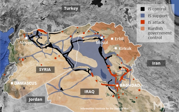
- This doesn't really answer your question, but here is a guide to major ISIS presence in Syria (and Iraq).
- It doesn't try to cover small locations, or isolated zones, but at least it presents major areas where they have a strong presence or control. Note that even in Raqqa, they don't have a strong presence in most of the territory. I think that this reflects the reality. How could they, with only 10000 to 30000 combatants (depending on the guestimates) have even a significant presence in a territory as large as Syria ? (counting both Syria and Iraq)
- The group producing this map is a major independent international conflict think tank based in the U.S. They have a mailing list if you are interested in following their detailed analyses, which appear almost every day (for Syria and/or Iraq) see. André437 (talk) 14:29, 6 December 2014 (UTC)
This is cool as source so is the ISW is well know for their anti Assad tendency. --Pototo1 (talk) 01:29, 7 December 2014 (UTC)
- Considering the numerous condemnations by the UN and affiliated organizations of the Assad regime for gross violation of human rights, and the massive civilian protests against the regime, one should expect that any objective reporting would be anti-Assad regime on average. Note that ISW positions are often critical of US gov't policies. Although currently focusing on Syria and Iraq, they cover other armed conflicts as well. André437 (talk) 21:39, 8 December 2014 (UTC)
No evidences from IS in As-Suwayda.
- Information too vague
- No Photos
- No Videos
- No Visual evidences
- SORH (Usual Anti Assad source) never report ISIS presence in As-Suwayda.
- This anti Assad source from December 5 no showing the ISIS in As-Suwayda.
Question
When they take these towns ?
When IS Captured something they usually executing and beheading a lit people.
If you want to prove the IS is in As-Suwayda you need to prove that town by town --Pototo1 (talk) 08:44, 8 December 2014 (UTC)
- ISIS militants controls some villages in Suwayda province and it is proven from many sources. So just carefully read this discussionhere So you must stop to revert other people's edits. Just understand that if you will continue provoke the war of edits you can be blocked by admins. Regards! Hanibal911 (talk) 13:34, 8 December 2014 (UTC)
No graphic information from IS in As-Suwayda. — Preceding unsigned comment added by 201.211.172.80 (talk) 15:54, 8 December 2014 (UTC)
- I would classify the ISW as a neutral source and not anti-Assad, unless you want the classify the UN and almost all other sources not pro-Assad as anti-Assad. I would also classify it as reliable. But note that the ISW covers only major control areas, so it would not be useful for small areas of control like villages, which is the focus of this section.
- Also note that I agree with Hanibal911 that one should reflect very carefully before reverting the edits of others. Either provide reliable contrary sources, or show how the sources provided by the original edit are not adequate. The simple lack of reports by some sources does not in itself negate reports by other sources. For example, SOHR often misses events in areas where they have few sources on the ground. And ISW never reports very small areas of control. André437 (talk) 23:10, 8 December 2014 (UTC)
ISW Is anti Assad the ISIS presence in As-Suwayda just no exist --Pototo1 (talk) 13:20, 9 December 2014 (UTC)
Qala'at Al Madiq - Hama
I have searched all available local news networks (pro-regime and pro-opp) and I can't find any clear information about the situation in Qala'at Al Madiq. Does anyone have a source that can help us know if it is: Besieged by the SAA - Contested - Under Truce - SAA held? The reason behind my query is that this village is strategic since it is considered the gateway to Al Ghab plain and and the second gateway to southern Idlib (other than Morek that is). So any useful sources on the situation? According to this source it is SAA held: https://twitter.com/PetoLucem/status/529701072777256960/photo/1 I also found that Huwwayjah village (slightly north of Qala'at Al Madiq) is rebel-held according to this relatively neutral source: https://twitter.com/PetoLucem/status/529002015062777856/photo/1 ChrissCh94 (talk) 18:52, 2 December 2014 (UTC)
- Only thing I've been able to scrounge up is this (assumedly pro-op) directory of rebel brigades - it lists Falcons of al-Ghab (Tajammu Suqour al-Ghab) as being headquartered in Qala'at al Madiq and is the sole source of the wikiarticle on the group. Boredwhytekid (talk) 21:06, 2 December 2014 (UTC)
- Washington Institute report titled "The Potential for an Assad Statelet in Syria" lists Qala'at Al Madiq as rebel held (pages 23 and 24) - written 12 months ago Boredwhytekid (talk) 21:14, 2 December 2014 (UTC)
- Alright thanks. I haven't seen any reports about conflicts there, not by SOHR not by SANA not by ANYBODY! So you guys think it's under some sort of ceasefire/truce? ChrissCh94 (talk) 22:36, 2 December 2014 (UTC)
I doubt it, but who knows. It's right on the frontline, so it doesn't fit the pattern of a ceasefire site, which have typically been isolated or surrounded areas. Let's keep looking for definitive confirmation on who controls it presently. In any case, I have to imagine that if/when the SAA makes a push into southern Idlib, up to date sources will present themselves. Boredwhytekid (talk) 13:46, 3 December 2014 (UTC) That's the annoying part! How come such an important town has so little info about it? ChrissCh94 (talk) 17:39, 3 December 2014 (UTC)
- According to the Wikipedia article about Qalaat al-Madiq (& sources in there):
- “… anti-government rebels gained control over much of the town, but the Syrian Army has maintained its position in the fortress, which overlooks the town. In September 2011 the police were evicted from the town by the rebels there. Services are provided to Qalaat al-Madiq's residents by rebel groups in the town, the largest of which is Suqour al-Ghab faction which fights under the banner of the FSA. In March 2012 Qalaat al-Madiq was shelled and targeted by heavy fire for a successive 17 days by the Syrian Army in an attempt to oust rebel forces. On 28 March the army entered the town, but were unable to take full control of it. Since the March clashes, there has been a relative ceasefire between the two sides, with a few incidents where the army has allegedly attacked demonstrations, which have continued in Qalaat al-Madiq, as of late November 2012.”
- So since there is no news of clashes, it might be that the status quo has persisted to this day. Also, notice on our map all the checkpoints around the town (they were sourced to a Sep 2013 report by the Institute for the Study of War based on a video by a rebel group). So the army seems to have this area under some sort of a containment… Tradediatalk 20:28, 8 December 2014 (UTC)
FSA fighter claiming that JAN captured him in Qalat al Madiq here Boredwhytekid (talk) 15:14, 9 December 2014 (UTC)
Map
I have removed {{Syrian Civil War detailed map}}, for the time being. It currently breaks the page. If it can be brought down to a reasonable size and remain useful, then it can be restored. All the best: Rich Farmbrough, 00:21, 8 December 2014 (UTC).
- The template was replaced by a scribunto module, for that very reason, so it is obsolete, and can be deleted.
- The scribunto module uses much less memory and works very well. André437 (talk) 05:38, 8 December 2014 (UTC)
- The map is far too large for any reasonable screen, and the page takes an extremely long time to load. The
{{navbar|Module:Syrian Civil War detailed map}}does nothing useful, it does not take one to the appropriate places when clicked (I have removed it but you can test it in the history version). The module itself generates about 8,500 lines of HTML, about three quarters of the 11,500+ lines of the whole page, which runs to 2,961 kilobytes. Without the map the page (unsurprisingly) loads in about 3 seconds, which is reasonable for such a large page. - If this level of detail is needed, then I would suggest splitting the page by governorate, and maintaining an overview here.
- All the best: Rich Farmbrough, 14:16, 8 December 2014 (UTC).
- See also. All the best: Rich Farmbrough, 14:43, 8 December 2014 (UTC).
- See also. All the best: Rich Farmbrough, 14:43, 8 December 2014 (UTC).
- The map is far too large for any reasonable screen, and the page takes an extremely long time to load. The
- I would disagree with splitting the map, as often the overlap between that adjacent governorates is very useful for understanding the situation. Many conflict zones cross governorate borders. (e.g. Homs/Hama, Hama/Idlib, Idlib/Aleppo, Quneitra/Daraa, among others. Only a few governorates are not much affected.) Note that when the map was much smaller, with many fewer points coded, it was still fairly slow to load. Switching to scribunto module sped that up considerably. Now it generally loads in much less than a minute. I would expect that users interested in following the map would likely leave it loaded, so the load time should not be a deterrent.
- As for having to scroll to see the whole map, that is very easily done, as least in the desktop mode. The only down side is that the icon index only shows up when at the bottom near the left. (It is normally possible in html to code a floating index, but personally I don't know how.)
- If the navbar removed wasn't automatically restored, its' removal doesn't seem to have led to any loss of function. All the clickable links seem to work as before. Even a (usually accidental) click on the background still links to the blank background image, which is rather inconvenient.
- I do agree that it would be much better to document everything on the main page (where the map is transluded), but it depends on editors to do the work in a fast changing situation. The editors are few and overloaded. However, as noted, changes are documented on the talk page. André437 (talk) 22:48, 8 December 2014 (UTC)
I cannot access the map anymore. What should I do to be able to edit it again?Paolowalter (talk) 10:26, 9 December 2014 (UTC)
Abu al-duhur airbase
At least four villages around Abu al-duhur airbase marked contested changed to green. Why? I is there a source for this? where? Please change back or please enlighten with a source.Rhocagil (talk) 02:25, 7 December 2014 (UTC)
I have same question. --Pototo1 (talk) 02:49, 7 December 2014 (UTC)
- The villages were changed to green because the same source that was used to mark them contested (see Talk:Cities_and_towns_during_the_Syrian_Civil_War#Abu Duhur Airbase), later said the army went back to airport after hit & run attack: https://twitter.com/EjmAlrai/status/538330384359235584 Also pro-gov source (https://www.facebook.com/news.edlib/posts/1577309989167381) confirmed it. Elijah J. Magnier (the main source) further explains that “SAA won't spread in an exposed area when the airport represents a better shelter and defense line”.
- However, later, this edit reverted back to contested based on http://umap.openstreetmap.fr/fr/map/desyracuse-syria-civil-war-8-december-2014_23532#13/35.7665/37.1334 However, if you look at the map source and if you click on the red dot labeled “Humaymat ad Da’ir”, it will write: “On November 27, reports of Government troops coming from Abu Duhur base, seizing Humaymat”. Notice that the date is 27 November. This is a day before the source that was used to make the villages green. So this desyracuse map is based on the attack (27 Nov), but does not take into account the return of troops to the airport (28 Nov). This is all in spite of desyracuse map being dated “8 december”. So the desyracuse map is outdated compared to our map. It is therefore a shame that our map was correct, but we made it wrong because we copied an outdated map! We should realize that a map on the internet made by some amateur is not a real source. A source is a professional media organization. Amateur maps on the internet (desyracuse, Syrian perspective/petolucem, Thomas von linge, archicivilian, etc.) are not professional media organizations, but rather they are our competitors. Therefore, they should be used with extreme care.
- Notice that previously to the attack, desyracuse map (for example the one dated November 8) had only the airport in red (and all other villages around it in green). So he made the villages red or contested because of the hit & run attack of Nov 27. However, he did not realize that the troops have returned back to airport. We were better than him this time and we might be better than him in the future… So keep that in mind, and use these amateur maps with extreme care. A real source is a media organization that has journalists on the ground and are reporting on what they are seeing… We don’t always have great sources to use, however, that does not mean that we should forget that some of the things we use to edit our map are shaky and should be used with care and a healthy dose of skepticism. The fact that desyracuse is considered pro-opp did not prevent him from overstating gov control around Abu Duhur! I am sure he didn’t do it on purpose. It’s just that it is hard to keep track of all the events (I wonder if he has research assistants) and no one called him from the airport to tell him the troops came back… Tradediatalk 20:28, 8 December 2014 (UTC)
- Good point, well explained. Why, among other factors, maps with dated annotations are much better. André437 (talk) 21:58, 8 December 2014 (UTC)
- TradediaThis source only said that army returned to air base. But source dont say that all military returned or the fact that they left the villages which was captured. Elijah J. MagnierAnd also this source just said that the villages had been captured but dont say that the all military just left the village because they could leave for protection of these villages NDF.here So need more data! 08:21, 9 December 2014 (UTC)Hanibal911 (talk)
- Also area where located village al khashir was marked as contested earlier in August because then it confirmed other pro opposition source.Archicivilians Hanibal911 (talk) 08:39, 9 December 2014 (UTC)
- The statement by Elijah J. Magnier: “SAA returned to air base.” was in response to the question: “Did they fall back or still hold those two villages?” So it means that the troops are no longer in the villages. Also, his statement: “SAA won't spread in an exposed area when the airport represents a better shelter and defense line” confirms this. We have to keep in mind the context. These are troops that have been under siege in the airport for a long time surrounded from every side by rebels. They are not in a position to keep control of towns. If in addition to this, we are not seeing reports of clashes in the area, then the most likely conclusion is that the troops returned to the airport.
- The pro-gov source does say they returned to airport. Here is a translation of the source giving details about the operation:
- “In early morning, army units heavily armed moved from Abu Duhur airport under cover of artillery and air force and began combing operations at the airport perimeter from the northern side until they reached the village of Humaimat Waldeyer 6 km north of the airport and the village was stormed by surprise and in hours has control of the village and combed and destroyed the nests of insurgents. Then the troops continued to progress to Almstrihh village 10 km north of the airport. The village was also stormed and violent clashes broke during which the Air Force intervened and destroyed a number of militants trucks. And after combing Almstrihh village at the time of sunset troops returned to airport and the results were successful where they killed and wounded dozens of terrorists and destroy their vehicles and their hideouts and captured a number of them also were confiscated light weapons and ammunition in addition to the herd of sheep was in one of the dens of terrorists in the vicinity of Humaimat Waldeyer. On the other hand, there were some light and medium injuries among the troops” (my emphasis added)
- Now this is a real source! And not the “one sentence” articles that you have been linking… This here tells you the whole story. The source is called “شبكة ادلب الأسد الاخبارية” which translates into “Assad Idlib News Network”. So they are based in the governorates & specialize in military events in the governorate. This is as opposed to other general media who will just copy the news in one uninformative sentence…
- Concerning al khashir, archicivilians in the link you provide says: ”No clear information about who is controlling al-Khashir checkpoint, but it was destroyed and burned by rebels in 2013” So since there is ”no clear information”, the right thing to do would be to comment out al-Khashir until more clear information becomes available. Tradediatalk 00:15, 10 December 2014 (UTC)