Hanibal911
Hanibal911, you are invited on a Wikipedia Adventure! edit

|
Hi Hanibal911!! You're invited to play The Wikipedia Adventure, an interactive game to become a great contributor to Wikipedia. It's a fun interstellar journey--learn how to edit Wikipedia in about an hour. We hope to see you there! |
Welcome to The Wikipedia Adventure! edit

- Hi ! We're so happy you wanted to play to learn, as a friendly and fun way to get into our community and mission. I think these links might be helpful to you as you get started.
--
| Mission 1 | Mission 2 | Mission 3 | Mission 4 | Mission 5 | Mission 6 | Mission 7 |
| Say Hello to the World | An Invitation to Earth | Small Changes, Big Impact | The Neutral Point of View | The Veil of Verifiability | The Civility Code | Looking Good Together |
Welcome to The Wikipedia Adventure! edit
- Hi ! We're so happy you wanted to play to learn, as a friendly and fun way to get into our community and mission. I think these links might be helpful to you as you get started.
--
| Mission 1 | Mission 2 | Mission 3 | Mission 4 | Mission 5 | Mission 6 | Mission 7 |
| Say Hello to the World | An Invitation to Earth | Small Changes, Big Impact | The Neutral Point of View | The Veil of Verifiability | The Civility Code | Looking Good Together |
Iraqi insurgency topic edit
- Hey there! I saw your recent large edits on Iraqi insurgency (post-U.S. withdrawal) and I decided to write here before taking action. As you can see the sections Jan-Jun and Jul-Dec are meant as an overview of major attacks within the country, almost always linking to an actual article. While it is true that some recent major attacks (or days with, let's say more than 75 casualties) have been missed, but we know have a detailed day-by-day account of events on the ground, which is nice, but is not fit for Wikipedia. It is unrealistic to think we are going to add every single day from now on, and add every day from Dec 2011 to the present as well, and for this case I wanted to tell you that I will be heavily editing the article later today and the majority of what was added will be gone - I will leave only a few major attacks that were missing + some random bits of info about monthly death toll statistics that is also valuable, but most of it will be gone. Please take a closer look at how the rest of the article looks and feel free to add to it, but in a constructive and realistic manner - WP is a collective process, so let's try to make the article better, but in a proper way, not just mindlessly adding buckets of text to it every day. I have put a LOT of effort and time into this article, and I would love to have someone help me out, especially if you follow the conflict and are knowledgeable :) Thanks in advance! Skycycle (talk) 11:33, 22 December 2013 (UTC)
- I see that you are continuously adding new information day by day, which IS NOT the point of the article, or any wikipedia article of this sort. I already explained my position above, 3 months ago, and you failed to reply. My next step will be to report this to higher authorities, because the article is slowly becoming a huge pile of text, full of information that is not always correct, or even relevant to the big picture. Please contact me to avoid any further possible action towards your account, as I WILL report this in a few days time! Skycycle (talk) 13:55, 12 March 2014 (UTC)
Please take a brief survey about The Wikipedia Adventure edit
Hi! Thanks for playing The Wikipedia Adventure, or at least considering it. We'd like to hear about your thoughts and feelings on the game, to help us improve it. Please take this brief survey: 10 minute survey.
- --thanks and cheers, Ocaasi 20:16, 23 December 2013 (UTC)
December 2013 edit
![]() Thank you for contributing to Wikipedia. We always appreciate when users upload new images. However, it appears that one or more of the images you have recently uploaded or added to an article, specifically Template:Syrian civil war infobox, may fail our non-free image policy. Most often, this involves editors uploading or using a copyrighted image of a living person. For other possible reasons, please read up on our Non-free image criteria. If you have any questions please ask them at the Media copyright questions page. Werieth (talk) 21:27, 24 December 2013 (UTC)
Thank you for contributing to Wikipedia. We always appreciate when users upload new images. However, it appears that one or more of the images you have recently uploaded or added to an article, specifically Template:Syrian civil war infobox, may fail our non-free image policy. Most often, this involves editors uploading or using a copyrighted image of a living person. For other possible reasons, please read up on our Non-free image criteria. If you have any questions please ask them at the Media copyright questions page. Werieth (talk) 21:27, 24 December 2013 (UTC)
South Sudan edit
Hello, I saw you have been active on the South Sudan article and wanted to ask you if you could jump in on the article's talk page and offer you opinion about the problems Lihass has with trusting the UN as a source and his constand reinserting of out-dated information. EkoGraf (talk) 18:58, 25 December 2013 (UTC)
Kurds in Al-Qamishli. edit
But the Syrian Observatory for Human Rights is reliable. It is a real source, and someone confirmed it in "comments" on the website. They said that the "YPG" said the same thing. --68.229.239.155 (talk) 23:06, 27 December 2013 (UTC)
Here is official confirmation from a reliable source.The Daily Star.
South Sudan conflict name change edit
Your opinion would be appreciated here [1]. EkoGraf (talk) 13:40, 31 December 2013 (UTC)
About Hezbollah soldiers in Syria edit
According to Al-Jazeera, Reuters, WashingtonInstitute there are about 1700-4000 Hezbollah fighters in Syria.
Dailystar.com.lb is anti-Hezbollah website of Lebanon.
Hezbollah have total 15,000-20,000 soldiers. Its not possible for them to send 10,000-15,000 soldiers in Syria to defend Assad. SpidErxD (talk) 22:05, 3 January 2014 (UTC)
Your sources Al-Jazeera and Reuters for 29 May, while my source The Daily Star for 24 December. Hanibal911 (talk) 22:13, 3 January 2014 (UTC)
- As i said Dailystar.com.lb is anti-Hezbollah website of Lebanon which is not valid source.
Hezbollah have total 15,000-20,000 soldiers. Its not possible for them to send 10,000-15,000 soldiers in Syria to defend Assad.
According to WashingtonInstitute article which is published on December 5, 2013, there are 3000-5000 Hezbollah soldiers in Syria.
If you think there are 10,000-15,000 Hezbollah soldiers in Syria please provide authentic source like BBC,Reuters,CNN etc. ThankYou SpidErxD (talk) 22:26, 3 January 2014 (UTC)
Anbar fighting edit
Have you thought about creating an article titled for example Battles of Ramadi and Fallujah? EkoGraf (talk) 22:52, 3 January 2014 (UTC)
- Start it and I will help you expand it. I thought about the title and maybe the title Ramadi and Fallujah uprising would also fit nice because some media outlets have also called it an uprising. We can always change the name in later discussions with editors. EkoGraf (talk) 15:03, 4 January 2014 (UTC)
- Someone already created it hehe 2013–14 Anbar clashes. EkoGraf (talk) 16:09, 4 January 2014 (UTC)
- I restructured that article about the IF-FSA conflict into the current Opposition-ISIS conflict. Syrian opposition–Islamic State of Iraq and the Levant conflict EkoGraf (talk) 19:12, 4 January 2014 (UTC)
- You were right to rename the article. Now this article looks more correct. Hanibal911 (talk) 19:18, 4 January 2014 (UTC)
- I restructured that article about the IF-FSA conflict into the current Opposition-ISIS conflict. Syrian opposition–Islamic State of Iraq and the Levant conflict EkoGraf (talk) 19:12, 4 January 2014 (UTC)
- Someone already created it hehe 2013–14 Anbar clashes. EkoGraf (talk) 16:09, 4 January 2014 (UTC)
- This [2] repeats content from the paragraph above, Ive removed it, btw.(Lihaas (talk) 09:15, 8 January 2014 (UTC)).
- Just a heads up that this "north of the Iraqi capital Baghdad, according to security and hospital sources. The deadly incident took place on Tuesday on a highway north of the city of Samarra, the sources said" seems like its copy+paste from the source. WP cant do that it is a copyvio. Seperately, Tuesday doesn't mean anything when you look back at it years for now. Also be aware of WP:OVERLINK and merely saying "sources said" as this is not a newspaper. I reworded it slightly.Lihaas (talk) 11:39, 8 January 2014 (UTC)
- Please be aware of WP:OVERLINK and do not copy+paste from the article. This is not a media story and further it is a copyright violation to blindly write what is from the source!.
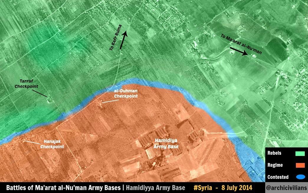
- This is a verbatim quote copy+pasted from the source "security forces backed by tanks engaged in heavy fighting with Al-Qaeda linked militants in the Albubali area, between Ramadi and Fallujah, a police officer said. "A big force last night attacked hideouts in an area of Albubali that had been turned into a stronghold for Al-Qaeda fighters and, since this morning, there have been fierce clashes between both sides involving army tanks," the officer said"(Lihaas (talk) 02:33, 10 January 2014 (UTC)).
- Just a heads up that this "north of the Iraqi capital Baghdad, according to security and hospital sources. The deadly incident took place on Tuesday on a highway north of the city of Samarra, the sources said" seems like its copy+paste from the source. WP cant do that it is a copyvio. Seperately, Tuesday doesn't mean anything when you look back at it years for now. Also be aware of WP:OVERLINK and merely saying "sources said" as this is not a newspaper. I reworded it slightly.Lihaas (talk) 11:39, 8 January 2014 (UTC)
Thanks for reminder. Hanibal911 (talk) 06:34, 10 January 2014 (UTC)
- Sorry to bother, but I implore you again not to copy and paste from sources as that is a copyright violation:
Here "fierce clashes have erupted between Iraqi special forces and al-Qaeda linked fighters in a village in the western Anbar province, officials say. The village, al-Bubali, lies between Fallujah and Ramadi, two cities in Anbar that are under siege by Iraqi security forces and their allies from Sunni Arab tribes" is a direct copy and paste from the first 2 lines of the source. I haven't checked the second source in that para, but it appears to be similar.Lihaas (talk) 05:27, 12 January 2014 (UTC)
E.Ghuta edit
That is exactly what I wanted to do yesterday but didn't have the time it is great like this as it represents what actualy happened in the area :) good job.Daki122 (talk) 16:28, 4 January 2014 (UTC)
I tried to show more accurately what the happening there. Hanibal911 (talk) 16:35, 4 January 2014 (UTC)
I agree with you except for Deir Salman, which you should mark contested. http://brown-moses.blogspot.co.uk/2013/12/the-rebel-offensives-in-east-ghouta.html
If you mark deir salman back to contested, I will leave the East ghouta region alone, so long as its not tampered with again until multiple reliable sources come through. Sopher99 (talk) 16:40, 4 January 2014 (UTC)
this source [3] notes Deir Salman under control army. Map for 21 December shows it under army control. Hanibal911 (talk) 16:55, 4 January 2014 (UTC)
Well Deir Selman is shown under government control by the pro-opp source so that does make it reliable an as far as I'm informed the rebels never reached Deir Salman and that is not only confirmed by por-government sources but also by pro rebel sources as well no need to change anything.Daki122 (talk) 17:25, 4 January 2014 (UTC)
Agree. You got a pro-rebel source saying the town is most likely government-held. EkoGraf (talk) 19:13, 4 January 2014 (UTC)
Shabiha and Jaysh al-Sha'bi edit
When the NDF showed up sources indicated that the Shabiha and other pro-government militias were being integrated into the NDF, while Jaysh al-Sha'bi was even speculated to already BE the NDF. For almost a year now there has been no mention of Shabiha and Jaysh al-Sha'bi in the conflict, or very minimal. Even SOHR has described, in its daily death tolls, the pro-government Syrian militiamen killed as all NDF. That suggests that those two have at this point become non-existent and have been completely merged into the NDF. EkoGraf (talk) 15:08, 8 January 2014 (UTC)
- Check their daily death tolls, in each one SOHR only says NDF members are killed. No mention of the two. The two do still exist but as subgroups of the NDF. Besides, the SOHR may as well be talking in that link of yours about those killed before the mergers. But the main point is they call them collectively the NDF in their daily reports. And Future and Sopher agree with me on this on the condition we note in brackets that the two still exist albait as part of the NDF. EkoGraf (talk) 16:51, 8 January 2014 (UTC)
South Sudan edit
As you are listed on the wikiproject page for South Sudan as a member, I was thus wondering if you are interested in collaborating on a page together? There is more info on the Wikipedia_talk:WikiProject_South_Sudan#Agricultural_page?Lihaas (talk) 07:16, 10 January 2014 (UTC)
NDF edit
That's because SOHR regards all the rebels the same except for ISIS and Nusra and thus calls the rebel fatalities collectively as rebel brigades. Also, we got sources from earlier in 2013 and from late 2012 confirming the start of a merger of those two government militias INTO the NDF. EkoGraf (talk) 16:09, 11 January 2014 (UTC)
Raqqa edit
I think the best solution for the raqqa problem is a green circle with a black ring. Kind of like hassakah and qamishli. Sopher99 (talk) 15:01, 12 January 2014 (UTC)
I agree. This will be best option. Hanibal911 (talk) 16:30, 12 January 2014 (UTC)
But here some more information. ISIL is now in control of 95 percent of Raqqa.Reuters Hanibal911 (talk) 21:17, 12 January 2014 (UTC)
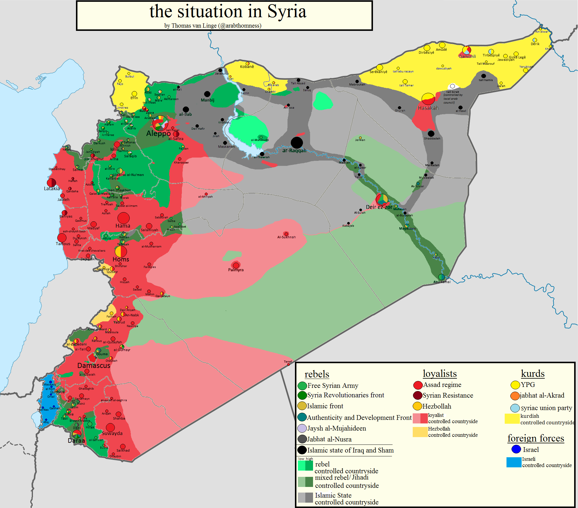
Here more map (opposition source) showing situation in northern part of Aleppo province. Hanibal911 (talk) 16:55, 23 January 2014 (UTC)
Azaz edit
Situation in azaz according to pro-opposition sources, in case you find it useful. https://twitter.com/ced_lab/status/426199220429672448/photo/1/large Sopher99 (talk) 16:15, 23 January 2014 (UTC)
In this situation, I will be grateful for any information. Hanibal911 (talk) 16:21, 23 January 2014 (UTC)
Ayyash edit
I saw you are good with adding new towns to the map. Could you please add the town of Ayyash in east Syria as government-held (its just north of Deir ez-Zor). We have both government [5] and opposition sources [6] confirming the towns capture by the Army. Also, the town of Tal Al-Azaeh should be added. We have a government source saying it was also captured, no confirmation from the opposition on this, but it should be marked at least as contested. Thanks! EkoGraf (talk) 00:29, 25 January 2014 (UTC)
I am not found on map city Tal Al-Azaeh. Hanibal911 (talk) 16:48, 25 January 2014 (UTC)
Re:Outdated sources edit
I cant understand your point. I dont see any problem to use old sources to add towns to the map, of course, only in the case that there arent newer sources available (As in the Nawa case, something the well-known vandal user we all know seems to not understand). If there are newer sources, good, lets use it (as they supersede the older ones), but if not, lets use the ones we have. As far as I know, there aint any WP rule that states that sources have expiration dates. And If we use that measure, for example, all the checkpoints should be removed from the map, as they were added months or years ago, so we dont now who control s them or if they even exists now.
Im starting to think that some users (not you, of course) are trying to do anything to avoid my edits. They used partisan maps (Syrian Persective, Cedric Labrousse) to add towns to the map with no problems or opposition, but when I started doing the same they suddenly discover that they were published on Twitter and oppose its use. Now, oppose the use of reliable sources with the excuse of being outdated (who decides that? and, wich is the outdate limit? one week? one month?). Unless you or other users found a better reason to avoid my edits, I ask you to restore them or I will do it by myself, as (if Im not wrong) Im not breaking any WP rule. Regards,--HCPUNXKID (talk) 16:53, 4 February 2014 (UTC)
I think you're partially right that sometimes we could be used older sources but only to add new cities and villages. But then we need to be 100% sure that it was not later sources indicate other information relating to a particular town or village. But it's not easy to do. Hanibal911 (talk) 20:31, 4 February 2014 (UTC)
Invitation to WikiProject Mass surveillance edit

A barnstar for you! edit

|
The Original Barnstar |
| hi hanibal, why you are undoing my changes?
these are real stuff. Thanks for your work anyway Barcaxx1980 (talk) 16:53, 6 February 2014 (UTC) |
I reverted all your changes because they unfounded. You have to specify sources which confirm all your changes. Hanibal911 (talk) 17:01, 6 February 2014 (UTC)
Okay, reliable source !! is Aljazeera reliable? — Preceding unsigned comment added by Barcaxx1980 (talk • contribs) 13:26, 7 February 2014 (UTC)
Yes it is a reliable source. Hanibal911 (talk) 13:29, 7 February 2014 (UTC)
Thanks man! for everything....
I don't know how to replay directly to your notifications! so I add it here.
Barcaxx1980 —Preceding undated comment added 22:08, 8 February 2014 (UTC)
Was happy to help. Hanibal911 (talk) 22:15, 8 February 2014 (UTC)
Re:The capitals of Syrian provinces edit
As far as I know, Raqqa is the only provincial capital not controlled by the Syrian gov., but by ISIS. And it seems that most of the road from Aleppo to Daraa (wich passes through Hama, Homs and Damascus and is the most important road in the country) is controlled by SAA and allied forces. That's what I know about that issue. Regards,--HCPUNXKID 16:23, 11 February 2014 (UTC)
Towns with no sources edit
As Alhanuty has removed the towns you added based on a previous WP map (something wich could be discussable, but at least you provide something to back your edit), you should remove the towns Sopher99 added WITHOUT A SINGLE SOURCE (see https://en.wikipedia.org/w/index.php?title=Template:Syrian_civil_war_detailed_map&diff=595067679&oldid=595059738 & https://en.wikipedia.org/w/index.php?title=Template:Syrian_civil_war_detailed_map&diff=595059407&oldid=595045023). I removed them for not being backed by any type of source, but he reverted my changes with one of his typical dumb and false argumentations. Lets oppose this flagrant double standards. Regards,--HCPUNXKID 19:05, 12 February 2014 (UTC)
I returned those the cities which were earlier added by me because there is confirmation from opposition source that these towns under control the army. Hanibal911 (talk) 19:28, 12 February 2014 (UTC)
https://en.wikipedia.org/wiki/Template:ANI-notice.Alhanuty (talk) 00:15, 14 February 2014 (UTC)
A discussion with mentions of you is taking place, see Wikipedia:Administrators' noticeboard/Incidents (section: User:Sopher99) edit
![]() There is currently a discussion at Wikipedia:Administrators' noticeboard/Incidents regarding an issue with which you may have been involved. Thank you.--HCPUNXKID 00:24, 14 February 2014 (UTC)
There is currently a discussion at Wikipedia:Administrators' noticeboard/Incidents regarding an issue with which you may have been involved. Thank you.--HCPUNXKID 00:24, 14 February 2014 (UTC)
Syria map edit
Regarding the map conflict only HPUNXKID appeared to had concenrs with Barcaxx. Indeed, I only saw you contact him about his use of pro-regime sites. Furthermore you and the other editors didn't have a problem with the use of wikimapia to add villages and towns so long as as it stayed within the clear defined boundaries of syria maps (like the BBC maps)
Like-wise for the same reason I took no issue with your additions to the deir ezzor province using twitter maps.
There fore your comment "Support block. I agree to other editors. The rules should be the same for all." is a bit in error, since I was abiding by a underlying rule I assume everyone was following.
I would like you to please reconsider my situation, and retract your support for a block/ban. Sopher99 (talk) 22:43, 14 February 2014 (UTC)
Sopher I wanted to retract of my support for a block / ban but your friend Alhanuty became threaten me and I now doubt whether I should do it. Hanibal911 (talk) 07:49, 15 February 2014 (UTC)
You also did the same thing,so you could be blocked also for this.Alhanuty (talk) 06:24, 15 February 2014 (UTC)
I added a citys in Tartous Province because that province is completely under control of army and this is confirmed by data from Wikipedia but this is also confirmed by many sources including the pro opposition sources. Maybe I was wrong adding two cities in province of Deir ez-Zor but this information confirmed pro opposition source. And at the moment no information confirming that rebels surrounded military in Deir ez-Zor hence road from Homs province under control of the army but if I wrong then I apologize. Also as you have probably noticed that I not returned them back because agree with your argument that maybe you're right and source of which I used to add them not entirely reliable. Hanibal911 (talk) 07:30, 15 February 2014 (UTC)
Re:Al Dumayr edit
The article in question was first published in Foreign Affairs, then re-pubished in the pro-opp. outlets. As FA is a reliable source, I think it should stay like that. Regards,--HCPUNXKID 22:38, 16 February 2014 (UTC)
Question about the Syrian map template edit
Hey, would you please tell me what exactly the 1 revert rule is?
Thanks Barcaxx1980 —Preceding undated comment added 00:16, 17 February 2014 (UTC)
Sophere99!!! edit
What is he doing Reverting for 3 or 4 times without any source. He is not even looking for reality, but playing with the map like a toy or a rubbish.
Barcaxx1980 —Preceding undated comment added 10:40, 17 February 2014 (UTC)
Sopher99 !!!!!!!!! edit
5 reverts in a row !!!! wow he made a record
What is he doing!!! some body sould stop him. He reverted 5 times with no source. You guys really made him crazy when you refused to give him those villages in Der-Alzor (for FSA against ISIS). Please give him Mars and tell him to leave the page. Opposition has no control in alawite and christian villages in Masyaf and west of Homs and Hama. and no control al all in Tartus. I gave him a map from opposition itself. It is very well known fact and he knows it very well, but as you refused to give him those villages in est of Syria, he will delete Damascus itself !!!
I know I am new, and I was not giving sources to every thing, but Hanibal and another user did tell me that and they guided me and checked my edits, and I am contacting them to understand how to make things in the right ways. But this guy Sopher99 is really amazing !!! He is a country himself and nobody can ever tell him what to do.
User:Barcaxx1980 —Preceding undated comment added 11:11, 17 February 2014 (UTC)
Babilla edit
Can you re-add the lime part , rebels only handed heavy weapons over (aritllery and such)
also it says both red and green flag were raised. Thanks Sopher99 (talk) 16:19, 17 February 2014 (UTC)
Also I agree with you on raqqa. Perhaps we can add a contested dot within Raqqa itself to represent the neighborhood. Sopher99 (talk) 16:29, 17 February 2014 (UTC)
Source said opposition fighters handing over heavy weapons and the regime raising its red, white, black and green flag there. There is not told about the rebel flag this source only listed all the colors of the Syrian flag. Regime troops raised the Syrian flag over the municipality of the southern suburb.The Daily Star NOW News
I now try of note the contested area in Raqqa and try to find more data confirming clashes in the city. Hanibal911 (talk) 16:35, 17 February 2014 (UTC)
Re:Al-Shaykh Saad and Adwan edit
Clearly, thats not acceptable, not only for the source (LCC) but for the media used to publish it (Facebook). I will revert it when possible.--HCPUNXKID 17:10, 17 February 2014 (UTC)
Hama villages edit
Below are the diffs that show Barcaxx adding villages without a source, or with youtube and twitter. I wouldn't have a problem except for the fact HCPUNX keeps reverting my villages I added with wikimapia.
Please help me remove these villages, I will continue myself after 24hours of my last revert.
or you can just revert HCPUNX's removal of my villages, and then we don't have to remove all these villages. Which ever way you feel is best. Sopher99 (talk) 20:29, 17 February 2014 (UTC)
Let us, as a compromise, I just bring back on the map villages that you added earlier. And we will not do such changes in the future. If you agree with me it would be the best solution. Hanibal911 (talk) 21:33, 17 February 2014 (UTC)
If you mean you'll re-add the rebel villages under the condition that no additional regime or rebel village gets added without a good reliable source, then I agree. Sopher99 (talk) 22:12, 17 February 2014 (UTC)
Here on this and agreed. Hanibal911 (talk) 22:38, 17 February 2014 (UTC)
Syrian civil war sanctions notice edit
As a result of a community decision, broad editing restrictions apply to all pages broadly related to the Syrian Civil War. These sanctions are described at Talk:Syrian Civil War/General sanctions and a brief summary is included below:
- Sanctions can be used against an editor who repeatedly or seriously fails to adhere to the purpose of Wikipedia, satisfy any standard of behavior, or follow any normal editorial process.
- If you inappropriately edit pages relating to this topic, you may be placed under sanctions, which can include blocks, a revert limitation, or a topic or article ban.
- A one revert per twenty-four hours restriction applies to articles broadly related to the Syrian Civil War, with the wording listed here.
- Please familiarise yourself with the full decision at Talk:Syrian Civil War/General sanctions before making any further edits to pages related to the Syrian Civil War.
- Sanctions imposed may be appealed to the imposing administrator or at the appropriate administrators' noticeboard.
This notice is effective only if given by an uninvolved administrator and logged at Talk:Syrian civil war/General sanctions#Log of notifications.
--Bbb23 (talk) 21:54, 21 February 2014 (UTC)
I understood everything. Thank you. Hanibal911 (talk) 05:32, 22 February 2014 (UTC)
Inkhil edit
source says regime bombs rebel held territories, immediately after that it says it bombed Inkhil. PBS Map shows Inkhil under rebel control. Please self-revert. Sopher99 (talk) 21:32, 24 February 2014 (UTC)
Damascus map out of date edit
We need to remove the map of Damascus as it is out of date please see the talk page on the Tamplate i the last section "Damascus map not working out of date and hard to update" I would quite like to hear your opinion as a reliable source says the front lines have changed and they are a lot different from the ones on the map and even on the Tamplate as it seems the Army has pushed the rebels away from Abadeh.Daki122 (talk) 15:23, 25 February 2014 (UTC)
I recommend you turn to this editor that edits this map. Hanibal911 (talk) 18:11, 25 February 2014 (UTC)
Ayyash 2 edit
What you said about the source on Ayyash when you reverted it was totally wrong. It doesn't talk about any "district" 'Ayyash, it says "بلدة عياش بريف دير الزور", which means "town of 'Ayyash in the countryside (rif) of Deir ez-Zor". Taken in full, it says "The LCC reported that opposition forces killed three soldiers as they repulsed an attack on the town of 'Ayyash in the countryside of Deir ez-Zor..." ~~ Lothar von Richthofen (talk) 20:51, 27 February 2014 (UTC)
But Aayash it is village not city. Hanibal911 (talk) 21:02, 27 February 2014 (UTC)
- Baldah means "town", and such semantic hair-splitting makes absolutely no difference anyway. Still referring the the exact same place. ~~ Lothar von Richthofen (talk) 21:14, 27 February 2014 (UTC)
- Some friendly advice: if you're going to try to make educated decisions on content from Arabic-language sources, you really should take some time to learn at least some basic elements of the language. It's clear from both the discussion here and past threads like this one that you don't know much at all about it. While Google Translate is certainly a powerful tool that can do a lot of the translation work for you, it is prone to error like any such automatic program is. By learning even a little bit about Arabic and how it works, you can make more accurate judgements on what Google Translate shows you.
- At the very least, you should familiarise yourself with Arabic letters. This table here is very useful for this—it's largely how I learned. By doing this, you can more easily recognise names (which online translators often get wrong—this is actually a big problem for them) and can also learn how to transliterate them in a more standard way when you add them to the map or talk about them in discussions. After this, you can move on to learning some vocabulary. It's particularly smart to learn some words commonly used in news reports so that you can quickly direct your attention to place-names or other important information in an article by searching for them on the page. Examples are geographical terms like "قرية" (qaryah=village) "بلدة" (baldah=town), مدينة (madīnah=city), or "ريف" (rīf=countryside); political terms like نظام (niẓām=regime), ثوار (thuwwār="revolutionaries"/rebels), معارضة (mu'āraḍah=opposition), or إرهابيين (irhābiyyīn=terrorists); and military terms like "حاجز" (hājiz=checkpoint), قوات (quwwāt=troops), or "مطار" (maṭār=airport/airbase). Remember that nouns often have the definite article ال (al-) added to them as a prefix. If you feel comfortable, you can even try learning some of the grammar too.
- For instance, if we take a look at the older discussion thread that I linked above, you say that the source doesn't mention the village in question (البويضة: al-Buwaydah or with a less-standard spelling "al-Boida"). That's not true, but given that Google Translate says that "البويضة" means "egg" (which it does, just not in this context), it's at least a somewhat understandable mistake. If you look at a translation and it has a random word like "egg" thrown in that doesn't make sense in context, you should immediately recognise that something is wrong—especially if it has a geographical term like "qaryah" in front of it. Since GT has a helpful function of highlighting the original word when you hold your cursor over the translated word, you can use the table of Arabic letters (or your memory, after enough practise) to figure out what's wrong. Here, you can see that the letters spell out a-l-b-ū/w-ī/y-ḍ-ah; after accounting for the fact that Arabic uses an abjad and so not all vowel sounds are honestly represented in normal writing, you can infer that it's talking about "al-Buwaydah".
- I'm not saying this to insult you or be mean to you; quite the opposite, I only want to help you. You're also not at all the only person who needs to do this; what I'm saying could be directed at most editors of the map. And I'm not at all trying to claim that I myself am at all "fluent" in Arabic; I can't even carry on a basic conversation in it. But trust me, you'll be surprised at how much better you can obtain information from Arabic sources if you just learn a little bit of the language! ~~ Lothar von Richthofen (talk) 23:30, 27 February 2014 (UTC)
The change to the status of Khirbet-Gazahleh from red to contested was never supported by reliable source. I made a search, presented on the talk page, that shows that the contested status of Khirbet-Gazahleh is not supported and nobody found any argument against it. Furthermore this town is considered gov held even in pro-opp maps. Therefore unless you find a reason justifying Khirbet-Gazahleh to be contested or revert it to red as it has alwaays been.--Paolowalter (talk) 10:28, 3 March 2014 (UTC)
Here is the source Hanibal911 (talk) 10:40, 3 March 2014 (UTC)
South Aleppo fighting edit
I am of the opinion as you and agree with you that the source for the fighting is too dubious and that it should stay red (government held). But that editor keeps continuing to edit war. So I proposed the lime ring as a compromise solution and one other editor has also agreed to it. So I would ask you and the other guy to refrain from further edit warring. If you agree to the compromise solution to temporarily put the lime ring for a week (and than remove it if no further fighting is reported) we can than shut out the other editor with a majority compromise. EkoGraf (talk) 11:24, 4 March 2014 (UTC)
- I have always believed that in any situation we need to find a compromise solution. And I agree with your proposal. Hanibal911 (talk) 11:29, 4 March 2014 (UTC)
- Help me out both at that guys talk page and at the maps talk page. I can not get through to him to follow the rules. 15:33, 5 March 2014 (UTC)EkoGraf (talk)
- He too does not listen to me. 16:19, 5 March 2014 (UTC)Hanibal911 (talk)
- Send him the 1RR warning. 17:38, 5 March 2014 (UTC)EkoGraf (talk)
- I have already notified the admins. You can also take part in the discussion.her Hanibal911 (talk) 17:44, 5 March 2014 (UTC)
- Send him the 1RR warning. 17:38, 5 March 2014 (UTC)EkoGraf (talk)
- He too does not listen to me. 16:19, 5 March 2014 (UTC)Hanibal911 (talk)
- Help me out both at that guys talk page and at the maps talk page. I can not get through to him to follow the rules. 15:33, 5 March 2014 (UTC)EkoGraf (talk)
March 2014 edit

{{unblock|reason=Your reason here ~~~~}}. However, you should read the guide to appealing blocks first. Bbb23 (talk) 23:35, 6 March 2014 (UTC)Ayn al-Tinah edit
I am not vandalizing anything. There were two villages in Quneitra and Qalamoun with the same name and by mistake I changed both and not only the one in Quneitra. The change in Quneitra is fully justified, syrian documents is relaible and nobody has shon any evodence of the contrary. Furthermore also SOHR reports the same new https://www.facebook.com/syriahroe/posts/501083430000000?stream_ref=10 I have already proved in the talk page under Quneitra section that the red assignment was wrong since the beginning due, probably, to an error in going from aran to english. The original article http://english.al-akhbar.com/content/people-golan-return-%E2%80%98shouting-valley%E2%80%99 was talking about a place in the north of Quneitra. Therefore, thanks for fixng the error on Qalamoun, but the other is correct and must be reverted.
It is extremely unfair to revert changes without previous discussion.--Paolowalter (talk) 21:34, 14 March 2014 (UTC)
I understand you but and you get me that we do not use Syrian Documents for editing the map. Also we do not use for editing data from facebook you must find more reliable source. Hanibal911 (talk) 21:58, 14 March 2014 (UTC)
Morek edit
Report by SOHR from today [7]. Fighting IN the southern side of the town. EkoGraf (talk) 14:43, 18 March 2014 (UTC)
I did not see this information when edited the map but even now we can not use this information because we do not use Facebook for map editing. Need to wait for the appearance of this information on the official website SOHR or in other sources. Hanibal911 (talk) 15:00, 18 March 2014 (UTC)
Ras al-Maara in Qalamoun edit
No mistake. Here is the english version on SOHR's facebook page [8]. Note Clashes are ongoing between islamic fighters, the ISIS and al-Nusra front from one side and regular forces, NDF combatants and Hezbollah fighters from the other in the Ras al-Ma’ara town, with reports that regular forces and Hezbllah progressed inside the town and took hold of large parts of it. The Army is advancing in both villages. :) EkoGraf (talk) 20:04, 18 March 2014 (UTC)
It is clear thanks to that explained! Hanibal911 (talk) 20:18, 18 March 2014 (UTC)
Syria: direct edit
Your view in this discussion [9] on the opposition source Syria: direct would be appreciated. EkoGraf (talk) 20:28, 21 March 2014 (UTC)
Talkback edit

You can remove this notice at any time by removing the {{Talkback}} or {{Tb}} template.
You can remove this notice at any time by removing the {{Talkback}} or {{Tb}} template.
Re: Template Syrian civil war detailed map edit
As you know, changes of status in the map must be backed by a source (if not, they could be reverted), so someone should warn that user about it. But about the 1RR rule, I dont think he broke it, as his edits were consecutive. Regards,--HCPUNXKID 22:01, 30 March 2014 (UTC)
1RR edit
Callanecc You blocked me on 10 days and I will admit the fact that I broke the rule 1RR but I did this when I tried to correct unjustified changes made editor Alhanuty. Because his actions are vandalism because he edited using sources that do not support his changes. Because when he edits it often distorts the data in source which he use as this he needed that make an edit.hereherehere Other editors are also trying to correct this actions but that does not stop him.hereherehere Perhaps you need to make an exception for this module Syrian Civil War detailed map which will allow the other editors to revert the wrong changes if they are made without providing the specific sources which can confirm such action. Hanibal911 (talk) 07:25, 10 October 2014 (UTC)
- WP:GAB states that you need to show that the block is no longer needed or was wrong in the first place. With the above you've shown the exact opposite of that. Blaming your actions on someone else shows that you won't take care in the future. Only one of the reverts you were blocked because of was a revert of Alhanuty. Also you need to re-read WP:Vandalism as the edits you've labelled as vandalism are not. The one revert rule on that page is doing it's job, if you believe that Alhanuty has a record of adding unsourced changes you need to present evidence of that at WP:AN or talk to them about it on their talk page first. As the community has imposed the restriction only the community can remove it, which I don't see happening as it's preventing edit warring on that page. Callanecc (talk • contribs • logs) 13:14, 11 October 2014 (UTC)
Rif Dimashq edit
Zabadani was confirmed last month to be under the same ceasefire deal as the towns around Damascus, so not contested. Bloudan is government-held per the opposition map, but I added a lime ring around it since its on the frontline. EkoGraf (talk) 10:47, 31 March 2014 (UTC)
Observatory 45 edit
Sohr confirms Observatory sitll in rebel hands. Your yahoo source only says state tv claimed syrian army recapture.
SOHRs reliability exceeds state tv.
http://syriahr.com/en/index.php?option=com_news&nid=2023&Itemid=2&task=displaynews#.UznDzvldVsM Sopher99 (talk) 19:45, 31 March 2014 (UTC)
Al-Malihah edit
Should we maybe create an article about a Battle of Al-Malihah if fighting for the town continues into the next day (we wait one more day)? And would you want to create it? I would clean it up. EkoGraf (talk) 14:44, 4 April 2014 (UTC)
- I think that it is necessary to create an article Battle of Al-Malihah because many sources say that the Syrian army launched an offensive in this city. Hanibal911 (talk) 14:52, 4 April 2014 (UTC)
Military objects edit
Im not too supportive of adding that infrastructure, but in case of adding it, I would choose the Panorama base, as its an army site, and not the police academy, because until now there's no police sites added, and I think that adding more new infrastructure would made the map more chaotic (for that same reason I dont support the add of oil fields like the T2, but it seems no one has opposed its inclusion, so I dont want to cause disruption. For example, I opposed the add of Aleppo power plant, but when it was accepted, I started to add other power plants in the map). By the way, I found more important to add towns like Al-Shoula, wich Alhanuty misinterpretate like ISIL-held (seems he thinks that in the AC map the territory where the black arrows are is ISIL-held, when they simply show the route of their attack), when its SAA (or NDF)-held. Could you revert his revert on my edit, as I dont want to break 1RR?. Regards,--HCPUNXKID 18:52, 12 April 2014 (UTC)
- I could do it but then I too break 1RR because today I already revert its editing. But I absolutely agree with you that this city is under the control of the army and the pro opposition source AC confirms this. Also I think that you are right and we need to remove the T2 oil pumping station because this object has no strategic value. Hanibal911 (talk) 19:08, 12 April 2014 (UTC)
Al Jabiyah edit
I agree with you it's written. But if you look to the place of the village itself, there is absolutely nothing... There is no village : http://wikimapia.org/#lang=fr&lat=32.940962&lon=36.010029&z=17&m=b&search=Al-Jabiyah Wikimapia is made by normal people, maybe someone made a mistake... What do you think about it ?Oussj (talk) 18:28, 24 April 2014 (UTC)
- Here this village on the other maps.GeoNamesMap CartaOpenstreetmap Hanibal911 (talk) 18:58, 24 April 2014 (UTC)
Re: Deir ez-Zor Governorate edit
Sorry for the delay, I think you're right on this issue, as the 3 towns you mentioned are not explicitly mentioned on that article, they must be removed from the map, as for example other towns I added without an explicit mention (based on a partial map) were removed later, so same must be done with that. Regards, --HCPUNXKID 14:43, 25 April 2014 (UTC)
Re:Al-Zabadani edit
I think the situation in Zabadani is still unclear, perhaps we should wait 24 or 48 hours to see what finally happens there. Regards,--HCPUNXKID 17:00, 26 April 2014 (UTC)
- I think you're right. Hanibal911 (talk) 17:04, 26 April 2014 (UTC)
Sopher 99 edit
As usual, that user is trying to mess with the map. He reverted my edit removing the towns in Deir Ezzor governorate added without specific source. So, we have two options: one is removing again that towns (that should be done by you, as I couldnt do it without breaking 1RR) and the other is taking him to the administrators board, as he perhaps (Im not sure at all) have broken the 1RR (see the hours of this & this edits). Regards, --HCPUNXKID 16:48, 27 April 2014 (UTC)
April 2014 edit
![]() Hello, I'm BracketBot. I have automatically detected that your edit to Cities and towns during the Syrian Civil War may have broken the syntax by modifying 1 "[]"s. If you have, don't worry: just edit the page again to fix it. If I misunderstood what happened, or if you have any questions, you can leave a message on my operator's talk page.
Hello, I'm BracketBot. I have automatically detected that your edit to Cities and towns during the Syrian Civil War may have broken the syntax by modifying 1 "[]"s. If you have, don't worry: just edit the page again to fix it. If I misunderstood what happened, or if you have any questions, you can leave a message on my operator's talk page.
- List of unpaired brackets remaining on the page:
- |<span style="display:none">r</span>[[File:Flag of Syria (2011 combined).svg|40px]
- raises tension in Syria] [[al-Jazeera]], 9 July 2013</ref> ISIS rebels withdrew from Al-Dana.<ref>[http://www.aawsat.net/2014/01/article55326685 Syria: ISIS agrees truce, withdraws from Turkish
It's OK to remove this message. Also, to stop receiving these messages, follow these opt-out instructions. Thanks, BracketBot (talk) 18:29, 27 April 2014 (UTC)
Inkhil edit
Homs edit
Per this map, I think 7, not 5, would be a better choice. https://upload.wikimedia.org/wikipedia/commons/0/08/Siege_of_Homs_Map.svg
Daraa edit
http://syriahr.com/en/index.php?option=com_news&nid=2230&Itemid=2&task=displaynews#.U2urpvl_tCh says that one fighter died of its wounds (from the fighting at the prison weeks ago) and seven others were killed by a pipeline explosion. Not 8 fighters killed in the prison.
Sopher99 (talk) 16:56, 2 May 2014 (UTC)
- Since the truce and the rebels must leave the city, we can not be sure they keep the same territory which they controlled before the armistice. So let's leave it at that and see because if all the terms of the armistice will be performed and the rebels leave Homs then all the city will be marked in red. Also source said that government troops have blockaded rebels inside a string of districts on the territory eight miles.The Daily Star Hanibal911 (talk) 17:14, 2 May 2014 (UTC)
- ... you do realize that Homs city is 19 square miles right? https://en.wikipedia.org/wiki/Homs Sopher99 (talk) 17:37, 2 May 2014 (UTC)
- Lets we note Homs as before and close this issue.compromise version because I think this option is the most appropriate in this situation. Hanibal911 (talk) 18:03, 2 May 2014 (UTC)
- ... you do realize that Homs city is 19 square miles right? https://en.wikipedia.org/wiki/Homs Sopher99 (talk) 17:37, 2 May 2014 (UTC)
Rebels not controlled Chemical Plant in rural Damascus with called Khan Abu Shamat edit
Hello there in the wiki map from Syrian conflict https://en.wikipedia.org/wiki/Cities_and_towns_during_the_Syrian_Civil_War
Some one put the Khan Abu Shamat chemical facility in Insurgents hands http://fotos.subefotos.com/d498ef8a09d1125b47da4f515475d321o.jpg
http://www.reuters.com/article/2014/05/02/us-syria-crisis-chemicals-idUSBREA410MY20140502 These Activists who obviously support the claim only = Activists say rebels have clashed with Assad's forces between Dumair air base, which they said came under heavy rocket fire from the rebels, and Sayqal air base about 40 km (25 miles) further east where the chemicals are believed to be held.
They said just believe...And they claim is only about Sayqal air base claiming this place was "shelling away by rocket" when they "believed" and are talking about air base no about Khan Abu Shamat that sounds very ambiguous coming from anonymous activists who only "believed".
They no talk about Khan Abu Shamat chemical weapon facility....
And before was confirmed the Dumair air base it's not under siege-
Basically I no found a single solid evidence the Rebels controlled this Chemical Weapon Facility.
Thanks for your time. — Preceding unsigned comment added by LogFTW (talk • contribs) 15:55, 10 May 2014 (UTC)
- In the source says that : "The diplomat said rebels have overrun the abandoned and emptied chemical base at Khan Abu Shammal, which lies between Dumair and Sayqal, and cut the road linking them."Reuters But I will try look for the data which will be able to clarify the situation with the Khan Abu Shamat Chemical Plant. But even if the rebels were there we can not be sure that they are still there. Hanibal911 (talk) 20:26, 10 May 2014 (UTC)
right. — Preceding unsigned comment added by LogFTW (talk • contribs) 17:54, 14 May 2014 (UTC)
Homs = Al waer (al-Wa'ar) still in conflict ? edit
I put this question here.
This zone in Homs stilling in conflict ? — Preceding unsigned comment added by LogFTW (talk • contribs) 17:56, 14 May 2014 (UTC)
- Yes, this area is still the conflict zone.The Daily Star But I track information about this and if will be other data then I'll change the status this area on the map. Hanibal911 (talk) 18:36, 14 May 2014 (UTC)
Military bases added based on name in Wikimapia edit
There is a real problem with the military bases that were added based on a name found on Wikimapia. The problem is that ANYONE can edit Wikimapia and put ANYTHING they like without any source or explanation. So in terms of finding military bases, Wikimapia is unreliable. I can go now to Wikimapia and put in Brigade 69 (Shaykh Yurbuty) in some random place. Then, I can come back and put it on our map. The problem is that Brigade 69 (Shaykh Yurbuty) does not exist, as I just invented it. That is why we need some source other than Wikimapia to mention the military base before we can put it on our map. In this case, any pro-gov or pro-rebel source is fine. Notice that our problem here is not about which party controls the area in question, but rather whether the military base exists or still exists.
For all the above reasons, Wikipedia rules forbid using “wikis” (such as Wikimapia) as a source. Wikipedia rule WP:USERGENERATED is very clear. It states: “open wikis are largely not acceptable as a source. This includes any website whose content is largely user-generated.” This is exactly the case of Wikimapia, as users (anyone) generate the content. So Wikimapia can only be used to get coordinates for something that is already validly sourced. Please let me know what you think. Tradediatalk 01:04, 19 May 2014 (UTC)
- In this I absolutely agree with you. I have long talked about it but then this problem was ignored. Hanibal911 (talk) 05:01, 19 May 2014 (UTC)
Latakia offensive edit
I could use your help with an anonymous editor here 2014 Latakia offensive (check edit history for the last several days) and here Wikipedia:Administrators' noticeboard/Archive262#2014 Latakia Offensive. EkoGraf (talk) 11:23, 20 May 2014 (UTC)
This city is already on the map. Hanibal911 (talk) 19:17, 22 May 2014 (UTC)
try found the location of this place edit
Hello Days ago was army reported the control from a place called Um al-Awsaj
sana.sy/eng/337/2014/05/18/545193.html https://www.facebook.com/SyrianArabNewsAgencySana/posts/740021592687037
If you got time put it on map. — Preceding unsigned comment added by LogFTW (talk • contribs) 17:43, 21 May 2014 (UTC)
- We cant use data from the pro government sources to display of army advances. But if you find confirmation of this data in neutral or pro opposition sources so I can add this town on the map. Hanibal911 (talk) 19:40, 21 May 2014 (UTC)
Here is another pro government source http://english.farsnews.com/newstext.aspx?nn=13930229000940
SANA usually reports the correct information most times.. Are the Lebanese and Iranian News agencies who usually exaggerated the things some times...Anyway the Iranian and Lebanese Media are very active following the conflict with professional Journalist, west media basically doing nothing just quoted everything who Anti Regime SOHR in London tell them and at the same time the SORH just quoted SANA for save his "Credibility"
But if you need "Third sources" there is a anti regime source who confirm that =
The army also took control of the village of Umm al-Awsaj in al-Sanamein in the Daraa countryside. http://www.al-monitor.com/pulse/security/2014/05/syria-national-coalition-defense-minister-resignation.html — Preceding unsigned comment added by LogFTW (talk • contribs) 16:24, 22 May 2014 (UTC)
Re:Al-Shahil edit
But you added that town based on this Al-Monitor article, wich calls Al-Shahil Nusra's main stronghold. While the Al-Shahil on the Euphrates river is a small city or a big town near the oild fields, the other Al Shahil is a remote small village. And due to the fact that the ISIS-"rebels" clashes had taken place mostly in the surroundings of the Euphrates & Khabur rivers, I doubt very much that the article refers to that tiny village, but to the Euphrates Al Shahil. Regards,--HCPUNXKID 17:02, 2 June 2014 (UTC)
- Ok! I think in this case you are right! Thanks buddy that all to me explained. Hanibal911 (talk) 17:12, 2 June 2014 (UTC)
Re:Aleppo province edit
I dont found that map important or reliable enough to be used, also most of the towns on the map had been added.--HCPUNXKID 21:51, 2 June 2014 (UTC)
Use of Twitter as a source edit
Although we agreed on use maps published on Twitter, I dont think that simply using tweets as a source for edits is good or even reliable. For example, you use a tweet for adding Ishtabraq to the map. Only few hours ago, the same Twitter account published a map of the zone with Ishtabraq on it. So I think its better to avoid the use of tweets and wait a little bit for confirmation by maps, websites or other more reliable type of sources. Regards,--HCPUNXKID 14:03, 3 June 2014 (UTC)
- OK buddy! Hanibal911 (talk) 14:52, 3 June 2014 (UTC)
Infobox edit
It was agreed before that Mahdi Army, Badr Brigades, Kata'ib Hezbollah and Asa'ib Ahl al-Haq should not be added (read the hidden tag just below the part you added in the editing template). We don't include every group that fights with Assad since they are numerous. Please self-revert your last edit and take it to talk. Fitzcarmalan (talk) 10:42, 4 June 2014 (UTC)
- OK! I agree with you that we should not add these groups. But I think that we should add the Arab National Guard because this combat unit which takes an active part in the battles. Hanibal911 (talk) 13:01, 4 June 2014 (UTC)
- I actually disagree again. How crucial is the Arab Nationalist Guard's role in combat? Is Assad incapable of winning certain battles without their support? There is also nothing unique about them since they are not the only nationlist group supporting the government. Please remove it for now and if you want you can initiate a discussion on talk so different editors can voice their opinions. Fitzcarmalan (talk) 16:07, 4 June 2014 (UTC)
- OK! Hanibal911 (talk) 16:15, 4 June 2014 (UTC)
Sources edit
Anti Regime May 25 https://twitter.com/CdricLabrousse/status/470534599479943168/photo/1
Pro Regime May 23 https://www.facebook.com/photo.php?fbid=827637347255514&set=a.777540598931856.1073741827.777533765599206&type=1&theater
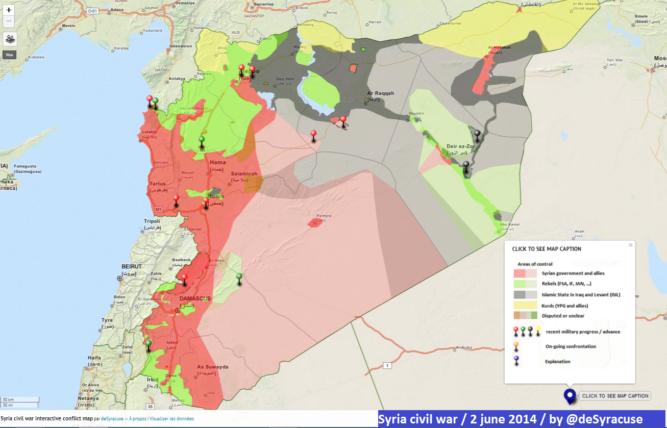
Map from June 2 (Dunno if it's pro or anti Government) https://twitter.com/deSyracuse/status/473403042243809280
Three maps coincide about Al-Shulah
This map used as source before is not credible - https://twitter.com/arabthomness/status/473225872942858240 creator is trolling seems he is just a follower racer. — Preceding unsigned comment added by LogFTW (talk • contribs) 07:30, 5 June 2014 (UTC)
- I agree with you that this map is not a reliable source. But now I'm not going to use this map to display the army advances, because I'm not sure that she is from the opposition source. Hanibal911 (talk) 08:09, 5 June 2014 (UTC)
^ Could be pro Rebel no idea really - At the moments who got more credibility are Larousse and Sy Per maps seems the regime controlled Al-Shulah however both ISIS and Army move with very high OPSEC - Since February 2014 ISIS avoid combats with the Army some Pro Insurgents twitter account claim ISIS and Army sharing territories and ISIS is backed by the Army but the high OPSEC level makes that very difficult to know - — Preceding unsigned comment added by LogFTW (talk • contribs) 09:44, 5 June 2014 (UTC)
Towns From as-Suwayda governorate edit
As as-Suwayda got many towns under Regime control there are I showing the locations from a fews https://en.wikipedia.org/wiki/Talk:Cities_and_towns_during_the_Syrian_Civil_War#Towns_From_as-Suwayda_governorate_.281.29
Putting it to map will be look like that = http://sia1.subirimagenes.net/img/2014/06/05/140605113023769226.jpg
__________
In both maps who you are showing to me (I see both before) these towns are in regime held territory the 99,99% from as-Suwayda governorate is in regime hands everyone who know about the conflict agree with that, I just edited this crap just one fvcking time and some one reverted it anyway.
But there is a fact like 50+ tows in as-Suwayda governorate are under regime control and are not in map i just draw 13 of these and were deleted.
Here is the discussion about these towns anyway.
These both map 1map 2 maps like most available are just partial pirate copies from Wikpedia map this people just watch here Cities and towns during the Syrian Civil who we made here and in base of that they make their own maps..
The most accurate map stilling be this one here on wiki https://en.wikipedia.org/wiki/List_of_armed_groups_in_the_Syrian_Civil_War#mediaviewer/File:Syrian_civil_war_2.png and it showing showing very clear the 100% from as-Suwayda countryside in Army Hands same case with these copies map 1map 2
These are a copy also http://www.liveleak.com/view?i=202_1395974204 http://www.liveleak.com/view?i=5db_1396132515
And same case 100% from as-Suwayda countryside in regime control. — Preceding unsigned comment added by LogFTW (talk • contribs) 07:53, 6 June 2014 (UTC)
Anyway when you can see there are not violations from rules because the towns who I draw and latter were deleted coincide 100% with all these maps http://www.liveleak.com/view?i=202_1395974204 http://www.liveleak.com/view?i=5db_1396132515 map 1map 2 https://en.wikipedia.org/wiki/List_of_armed_groups_in_the_Syrian_Civil_War#mediaviewer — Preceding unsigned comment added by LogFTW (talk • contribs) 08:12, 6 June 2014 (UTC)
June 2014 edit
{{unblock}}. However, you should read the guide to appealing blocks first. Bbb23 (talk) 19:08, 7 June 2014 (UTC)
Hanibal911 (block log • active blocks • global blocks • contribs • deleted contribs • filter log • creation log • change block settings • unblock • checkuser (log))
Request reason:
Why you blocked me from editing for a period of one week for violating WP:1RR rule although I am not break WP:1RR when editing of this article Template:Syrian Civil War detailed map is probably this mistake. Hanibal911 (talk) 19:40, 7 June 2014 (UTC)
Decline reason:
Per below. — Daniel Case (talk) 22:06, 7 June 2014 (UTC)
If you want to make any further unblock requests, please read the guide to appealing blocks first, then use the {{unblock}} template again. If you make too many unconvincing or disruptive unblock requests, you may be prevented from editing this page until your block has expired. Do not remove this unblock review while you are blocked.
It takes two reverts to violate 1RR. You reverted three times today, at 4:22, 14:50, and at 18:48 UTC.--Bbb23 (talk) 19:54, 7 June 2014 (UTC)
- You are wrong because I only once revert editing which made the editor Paolowalter.18:48 but hereit is not a violation of 1RR as it is simply an adjustment which has not changed very essence of the edit and here I also made small corrections which also did not change the essence of changes and it is also not a violation of 1RR. Hanibal911 (talk) 20:26, 7 June 2014 (UTC)
- That page's edits are a series of adjustments, some large, some very small. Each of your three edits changed the content of the page and was clearly a revert. You're not new to this. If you can't figure out what is and what isn't a revert, then don't edit the page more than once in a 24-hour period. Short of obvious gamesmanship, you should then at least be safe from 1RR.--Bbb23 (talk) 20:39, 7 June 2014 (UTC)
- I ask you again to look my edits and you will see that I not revert edits of other editors I just corrected them. After all, if you look you will see that the editor LogFTW added some villages from the Suwayda province to the list of towns and villages of the Dara province and I just moved them to the list of towns and villages the Suwayda province according to the map but I'm not revert his editing. So I'm helped him but I was not going to break WP:1RR. Also, I added source confirming his editing and I only helped a newbie.here. Also in this case, if I broke WP:1RR I did it not intentionally simple if you look at all the previous changes in this article Template:Syrian Civil War detailed map you'll notice that when we indicate on the map that the city besieged we mark it differently and not as did the editor Paolowalter and I wanted help him correct this. Yet I am not asking you to cancel my punishment I just ask you him to soften. Hanibal911 (talk) 09:22, 8 June 2014 (UTC)
- That page's edits are a series of adjustments, some large, some very small. Each of your three edits changed the content of the page and was clearly a revert. You're not new to this. If you can't figure out what is and what isn't a revert, then don't edit the page more than once in a 24-hour period. Short of obvious gamesmanship, you should then at least be safe from 1RR.--Bbb23 (talk) 20:39, 7 June 2014 (UTC)
Khaneqin edit
You have to know that media often interchanges between provinces, districts and cities. For example, there are still report that talk about Kerkuk being partially held by insurgents, while the city itself is clearly in the hands of Peshmerga. The writers of such news mean that the province of Kerkuk is partially held, but don't indicate this difference. This is the same with other cities/provinces/districts in Iraq like Khaneqin. The city itself is in hands of the Peshmerga but parts of the district not, like Saadiya, where fighting is continuing.
NadaCambia — Preceding unsigned comment added by NadaCambia (talk • contribs) 14:44, 15 June 2014 (UTC)
Jarabulus edit
I forgot to mention this source, [10] hopefully you'll understand why I changed it to contested & lift my ban.
Benjamin 145 (talk) 19:48, 20 June 2014 (UTC)
- But what does this have to do with to your editing. Hanibal911 (talk) 20:00, 20 June 2014 (UTC)
My apologize, wrong link. [11]
"The YPG captured several buildings at the entrance of the northern Aleppo city of Jarabulus from the ISIL, as well as the water facilities."
Benjamin 145 (talk) 07:48, 21 June 2014 (UTC)
- But I think that is not need now mark the city Jarabulus to contested because your source said that the YPG fighters was captured several buildings at the entrance to the city. I think until we get more information about the situation in Jarablus we can to install a yellow circle around the city. But if appears the data confirming that the clashes are already in the city I'll change status the city Jarabulus to contested. I hope you will agree with me. Hanibal911 (talk) 09:19, 21 June 2014 (UTC)
Semi-protect edit requests edit
Please mark the semi-protect edit requests as answered after you have either denied or accepted the edit. :) — LeoFrank Talk 04:02, 21 June 2014 (UTC)
May be ISIL taken three news villages in Deir Ez Zor Source. edit
The opposition activist group Syrian Revolution Youth Coordinatorship said in a written statement that ISIL rebels captured al-Muhasan, al-Buamr and al-Bulil regions of Deir ez-Zor from the Free Syrian Army.
http://www.worldbulletin.net/news/139355/isil-executes-free-syrian-army-fighters
I dunno what is the quality and tendency of this source but important to know anyway — Preceding unsigned comment added by LogFTW (talk • contribs) 16:43, 21 June 2014 (UTC)
- These cities are already on the map and marked under control ISIL. Al Muhasan, Abu Layl(al-Bulil) and Al bu Muayt(al-Buamr). Hafez and Muhassen in Deir al-Zor. But I cant find on the map of city of Hafez which ISIS seized on Friday.The Daily Star Hanibal911 (talk) 17:25, 21 June 2014 (UTC)
Ok srry I'm not very active on it now — Preceding unsigned comment added by LogFTW (talk • contribs) 22:38, 22 June 2014 (UTC)
Re:Archicivilians map edit
Well, we all know that Archicivilians is a pro-opp source, but also that its an anti-ISIS source as well as Anti-SAA source. If we follow the line that other editors used to revert my edit, the four red towns south of Tabqa must be deleted, as they were first added basing on a pro-gov. map (Syrian perspective), and later based on a pro-opp & anti-ISIS map (Arab Chronicle), so according to that line of thought we cannot use it, as that last source is anti-ISIS. As usual, I only expect the same rules 4 all...--HCPUNXKID 22:11, 22 June 2014 (UTC)
- Source Archicivilians this frankly the anti-government source and data from this source can be deliberately reduce the areas which under army control and thus increase the territory under the control of anti-government insurgent groups. And given the fact that the source is against the governments of Syria and accordingly it data can be deliberately skewed in favor of any anti government groups it can be FSA or ISIS thus we can not use his data to display success FSA or ISIS. So I strongly suggest you find a more reliable sources that can confirm to the fact that part of the Hama province under control of ISIS. Hanibal911 (talk) 06:42, 23 June 2014 (UTC)
Jardaqli edit
Hi! The village of Jardaqli is alreay on the map, immediately southwest of Tuz. You can even see it here. Roboskiye (talk) 19:27, 25 June 2014 (UTC)
- You are not quite right because the city Chardaghli which I added to the card is located south of the city of Kirkuk.her Hanibal911 (talk) 19:43, 25 June 2014 (UTC)
Sheikh Zayyat edit
Zgharo edit
Agree, it should go red. EkoGraf (talk) 18:27, 29 June 2014 (UTC)
Re: Sheikh Zayyat edit
https://www.google.es/maps/place/Sheikh+Zayat/@36.2557977,37.2731567,13z/data=!4m2!3m1!1s0x152ffda19e931d77:0x147a2899a37ecdaa. So already in Aleppo city map.--HCPUNXKID 14:13, 30 June 2014 (UTC)
ISIS advance edit
Based just on these two [13][14] I think we have enough reason to change them all to black. EkoGraf (talk) 14:51, 3 July 2014 (UTC)
Assal al-Ward edit
After a long discussion [[15]] I no found substantial evidences Assal al-Ward is total or partiality conflict / Contested - besiege / surrounded This is the official Report from SANA near Assal al-Ward.
Yes in the area are some sporadic insurgent presence but they are not able to make a effective block to any sector of the town.
Anyway I planing keep it like is now some days only for satisfied this user who want put something green there.
Deir ez-Zor governorate edit
The towns are still rebel-held [16]. EkoGraf (talk) 02:17, 6 July 2014 (UTC)
- I think Reuters didn't check its facts on this one even though I consider it more reliable, because the same day SOHR reported the eastern towns of the governorate falling to ISIS they reported those couple of towns in the western part were still rebel-held. And there has been no new info on them since. So I would wait. EkoGraf (talk) 16:19, 6 July 2014 (UTC)
al-Sheikh Hadid edit
Agree. I will do it. EkoGraf (talk) 16:30, 6 July 2014 (UTC)
Operation Canopus Star edit
I created a new article Operation Canopus Star. Seemed appropriate. EkoGraf (talk) 20:03, 8 July 2014 (UTC)
Syrian civil war map edit
Hi, I dont know what you edited but after you added (some changes in Idlib per pro opposition source https://pbs.twimg.com/media/BsCaBcyCAAEMwKu.jpg:large) to the map, everything has moved off coordinates and slightly off the map. If you could fix it that would be great otherwise I might just undo the whole edit because I dont know where the problem is.
regards Jumada (talk) 11:44, 9 July 2014 (UTC)
- I corrected the mistake! Regards Hanibal911 (talk) 11:54, 9 July 2014 (UTC)
Opinion needed edit
Your opinion would be appreciated on a discussion an editor has requested (rather at length I would say) here ‘Talk:Syrian Civil War#Problems and errors in our presentation of events April–May2011 in Daraa, Homs, Baniyas’. EkoGraf (talk) 15:28, 12 July 2014 (UTC)
Al-Malihah edit
I would agree that we should ask that the western side of the town be marked as Army-held because that was already confirmed some time ago but the map editors for some reason marked the whole town as contested. I think the town should be marked as divided down the middle until we get independent confirmation of the whole town being captured by the military. EkoGraf (talk) 17:27, 12 July 2014 (UTC)
I dunno if the Army controlled all the area but is very probable the Army controlled part of that I THINK the Army controlled at least the west area of Malihah so some areas are safe for journalists I see Severals reports from Syrians TV Channels / News agencies Inside Malihah these are some of them.
- SAMA TV June 15 I think it showing civilians returning to some West Malihah areas.
- Syria Alikhbaria June 15
- SANA June 11
- SAMA TV June 10
- Syria Alikhbaria June 10
- SANA June 10
- SANA June 6 Disabling IEDs after secure the area.
- SAMA TV June 6
- Russia Today in Arabic
- Syria Alikhbaria May 12
- Syrian TV May 10
- Syria Alikhbaria May 7
- Syria TV May 5
- Syria TV May 4
- SAMA TV May 4
- SANA May 3
- Syria TV April 5
- Lebanon Al Madayeen April 3
Based on the reports seems happens three Assaults to west of Malihah first one in April 2014, second Staring may and last one at the moment in June 2014 in all these Assault the Insurgents lost ground and Army doing small gains (No Substantial gains but gain anyway) I estimated the Army controlled at the moment between the 60% to 80% to Malihah
Yes I know "Syrian Controlled media" mostly of these reports but are sources anyway using professionals press teams are not Anonymous a "Activists" professional Journalists in the terrain.--LogFTW (talk) 01:33, 13 July 2014 (UTC)
removing green circles around Assal al-Ward edit
I decided removed the green circle around Assal al-Ward we keeping more than a week a insurgent presence who basically no exist or not enough I posted (Before and Again) many sources who suggest the insurgent no blocked the west way of Assal al-Ward https://en.wikipedia.org/wiki/Talk:Cities_and_towns_during_the_Syrian_Civil_War#Assal_al-Ward_Should_be_have_full_red_again This is a cites and town map it's not a map about held territories, unfortunately is the insurgent have presence in some rular low populated areas we no have mode how to draw them.
Here are changes who we used more than a week anyway (Basically for satisfied anyway
Boredwhytekid's edition =
{{# invoke: location map|mark |Syria |lat=33.864|long=36.416 |mark=Location dot lime.svg |marksize=10}}
Your edition =
{{# invoke: location map|mark |Syria |lat=33.866|long=36.411 |mark=Location dot lime.svg |marksize=9}}
- Hey buddy I think that as long as no need to remove this designation but as soon as we get new data from a reliable source I immediately remove this designation. But if we now remove this designation but it will re-add this designation in this case admins can block us for the provoking war of editors. Hanibal911 (talk) 06:09, 13 July 2014 (UTC)
All sources are very solid there are not a permanent insurgent presence blocking the west of Assal al-Ward a lot reports in the area too More sources than many others towns who are in full Red. It's nothing personal It's a fact what I can do ?
The map keeping more than a week a permanent presence in Al Ward who no exist just for satisfied him.
Keep a incorrect change on the map just because this user want it ?
We never will be have a news sources because the insurgents retreat from the west the same day when they launch a low scale attack. — Preceding unsigned comment added by LogFTW (talk • contribs) 14:48, 13 July 2014 (UTC)
Revert of Luhansk Oblast map edit
Hi! I find your revert of this map a bit strange. A more detailed reasoning and elaborated questions can be found at your Commons discussion page. All the best.--Paracel63 (talk) 18:58, 13 July 2014 (UTC)
Tikrit and the refinery edit
The district where the fighting was reported is the one where the university is, which is the very northern edge of Tikrit (outskirts/entrance). Sources from the last two days showed ISIS is in control of 99% of the refinery, except one building where 50 SWAT officers are holed up under siege and being starved out [17][18]. And Atta not really reliable (I think he was the one who claimed the recapture of Tikrit at one point....or two). EkoGraf (talk) 15:48, 14 July 2014 (UTC)
Maydaa on Damascus map edit
Some people on Damascus map is always reverting the Maydaa changes in Damascus https://commons.wikimedia.org/wiki/File:Rif_Damashq.svg
But they not providing sources for doing the changes.
The information about Maydaa is very poor but at the moments these are the only two sources who I found Source 1 Source 2
Both sources coincided 100% - So if we no have any news it must be keeping in red. — Preceding unsigned comment added by 190.203.205.104 (talk) 05:03, 16 July 2014 (UTC)
Cities and Towns map = Rahjan in Hama edit
Some one is changing this town to contested and latter to green but this was in red according to previously map.
SOHR and pro insurgents twitter account are not sources is against the rules used pro Insurgent sources (All insurgents factions) to showing insurgents advances against the Government
I report that on talkpage [19] but nobody pay attention me.
I ask you because I'm not able to edit at the moment.
I think If nobody have solid sources it must be change to red again. --Pototo1 (talk) 19:58, 17 July 2014 (UTC)
Deir ez-Zor governorate edit
Since SOHR has stated ISIS controls the whole province except the government-held areas of the provincial capital, I will change from blue to black because the source is newer and more neutral (the Institute has shown pro-opp tendencies in the past). Besides, reports do say that generally in all of the ISIS territories ISIS leaves local tribes to administer themselves while their troops go to the frontlines (same goes for Iraq). As for the T3 pumping station, I agree with you, that other editors conduct was Original Research. EkoGraf (talk) 18:11, 18 July 2014 (UTC)
Gas field edit
Made a new article Battle of the Shaer gas field. Update with info you deem appropriate. EkoGraf (talk) 02:55, 19 July 2014 (UTC)
Ayn Issa in Raqqa edit
Several sources said or suggests this place is controlled by the army is a place very close to the brigade 93 the Remains from 17 division were relocated there.
Here are a lot sources. https://en.wikipedia.org/wiki/Template_talk:Syrian_Civil_War_detailed_map#Most_sources_suggests_Ayn_Issa_is_controlled_by_Army
Based on sources yes all suggests the army controlled that, but there no exist a TV Report inside the town so no visual confirmation.
What you think ? — Preceding unsigned comment added by LogFTW (talk • contribs) 16:16, 27 July 2014 (UTC)
Ayyash town in Deir ez Zor edit
A lot solid evidences including extensive visual confirmation suggests Deir ez Zor is controlled by the Army but this is black on map.
https://en.wikipedia.org/wiki/Talk:Cities_and_towns_during_the_Syrian_Civil_War#Ayyash_is_in_Government_control_stop_to_change_that_to_black. — Preceding unsigned comment added by Pototo1 (talk • contribs) 21:16, 1 August 2014 (UTC)
Why did you change the Hama area quoting a map about Jisr Shugur? A mistake in quoting the source? Paolowalter (talk) 16:24, 3 August 2014 (UTC)
hasakah city edit
aranews,also mention that the regime pulled out of hasakah city,and that the city is fully YPG controlled.Alhanuty (talk) 16:27, 3 August 2014 (UTC)
- Understand ARA News is a pro opposition source and its information can not be used to display the progress of the rebels. But even this source acknowledges a temporary alliance Army and kurds against the IS and that now two sides protect the city.source Hanibal911 (talk) 16:39, 3 August 2014 (UTC)
Qalamoun offensive (June 2014–present) edit
Created a new article Qalamoun offensive (June 2014–present). EkoGraf (talk) 13:21, 4 August 2014 (UTC)
Ras al-Ayn edit
Hasaka under YPG control edit
The pro-regime forces guard two buildings in entire Hasaka city, which is totally negligible. This is even mentioned in your source: On the other hand, the pro-regime military forces, who are stationed at al-Hasakah governorate building. Roboskiye (talk) 20:55, 6 August 2014 (UTC)
Disambiguation link notification for August 9 edit
Hi. Thank you for your recent edits. Wikipedia appreciates your help. We noticed though that when you edited Iraqi insurgency (2011–present), you added a link pointing to the disambiguation page RT. Such links are almost always unintended, since a disambiguation page is merely a list of "Did you mean..." article titles. Read the FAQ • Join us at the DPL WikiProject.
It's OK to remove this message. Also, to stop receiving these messages, follow these opt-out instructions. Thanks, DPL bot (talk) 09:09, 9 August 2014 (UTC)
Hama edit
Aleppo edit
Where did you get this source https://pbs.twimg.com/media/Bsi8_1ACMAMCpc0.jpg:large.Paolowalter (talk) 17:36, 12 August 2014 (UTC)
- I dont remember exactly but it was a reliable source. Hanibal911 (talk) 19:14, 12 August 2014 (UTC)
- The aleppo battle page is in disarray because of super biased editor. They refuse any change in favour of the government. Other than reverting their chnages I do not know what to do. Many modifications are warranted on the map.Paolowalter (talk) 11:20, 14 August 2014 (UTC)
YPG in Hasaka edit
Regarding this edit: You are wrong. Removing unsourced material is not original research, which is actually a totally different issue. According to Wikipedia editing policy: Unsourced information may be challenged and removed. So you are tooooo biased, especially in favor of the vanishing aLawite aRab regime. Roboskiye (talk) 16:06, 14 August 2014 (UTC)
Alhanuty edit edit
Please revert his edit [20]. I cann't because I did that one from before today. Last stronghold does not mean its the last government position in the province. There have been no reports those villages had reverted back to ISIS control. Not to mention the term stronghold refers to fortifications that are military constructions or buildings designed for the defense of territories in warfare, and also used to solidify rule in a region during peace time. And a military airport is exactly that. Not towns and villages. EkoGraf (talk) 19:11, 14 August 2014 (UTC)
- Of course, I can revert this editing but today I revert one edit. And he can accuse me of violating 1RR rule. Hanibal911 (talk) 19:29, 14 August 2014 (UTC)
if you read the SOHR source you will find it says and i quote" violent clashes have continued between the IS fighters and the regime forces in the south and east from the Military Airport of Al Tabaq" how come them does assad control those far villages if the clashes are already now occuring on the south and the east of the airport,and okay i will self-revert ayad kabir,because no clashes were mentioned on the north or west.Alhanuty (talk) 19:44, 14 August 2014 (UTC)
https://www.facebook.com/syriahroe/posts/569242349850774
- Also here on 11 August SOHR reported about clashes between IS fighters and the regime forces near Al Ajrawi which located in an area which is under control IS according the pro government map.source Hanibal911 (talk) 20:00, 14 August 2014 (UTC)
- EkoGraf You can fix a mistake which do Alhanuty because he put green circle around the town Kanaker but SOHR clear that the regular forces bombarded Kankar town outskirts and another areas in al-Tayba town. But Sohr not said about clashes around or near the town Kanaker.source And why he change size of the town Kanaker and noted him how just village.here His actions are harm the map! Hanibal911 (talk) 16:36, 11 October 2014 (UTC)
- EkoGraf Maybe ISIS use Chemical Weapons against Kurdish Fighters in Kobane? And I think need display this information in the article Siege of KobanêInternational Business TimesMiddle East ForumRTThe Jerusalem Post Hanibal911 (talk) 09:55, 14 October 2014 (UTC)
- EkoGraf You can fix a mistake which do Alhanuty because he put green circle around the town Kanaker but SOHR clear that the regular forces bombarded Kankar town outskirts and another areas in al-Tayba town. But Sohr not said about clashes around or near the town Kanaker.source And why he change size of the town Kanaker and noted him how just village.here His actions are harm the map! Hanibal911 (talk) 16:36, 11 October 2014 (UTC)
- Also here on 11 August SOHR reported about clashes between IS fighters and the regime forces near Al Ajrawi which located in an area which is under control IS according the pro government map.source Hanibal911 (talk) 20:00, 14 August 2014 (UTC)
- EkoGraf I need your help in a situation with the editor Alhanuty. He edits without any reasons. Here you can see this.herehere This is vandalism. He edits how he want it and he does not even want to listen to those who tell him that he is wrong. Hanibal911 (talk) 20:25, 9 November 2014 (UTC)
- Done [21]. EkoGraf (talk) 13:01, 10 November 2014 (UTC)
- EkoGrafThank you for your help. But you probably made a mistake because you noted under the control the army the village of Khirbat al Atrah which located near the city Nubl but need marked under control by army the village of Khirbat Bajjah which located to north the city Nawa.here Hanibal911 (talk) 13:27, 10 November 2014 (UTC)
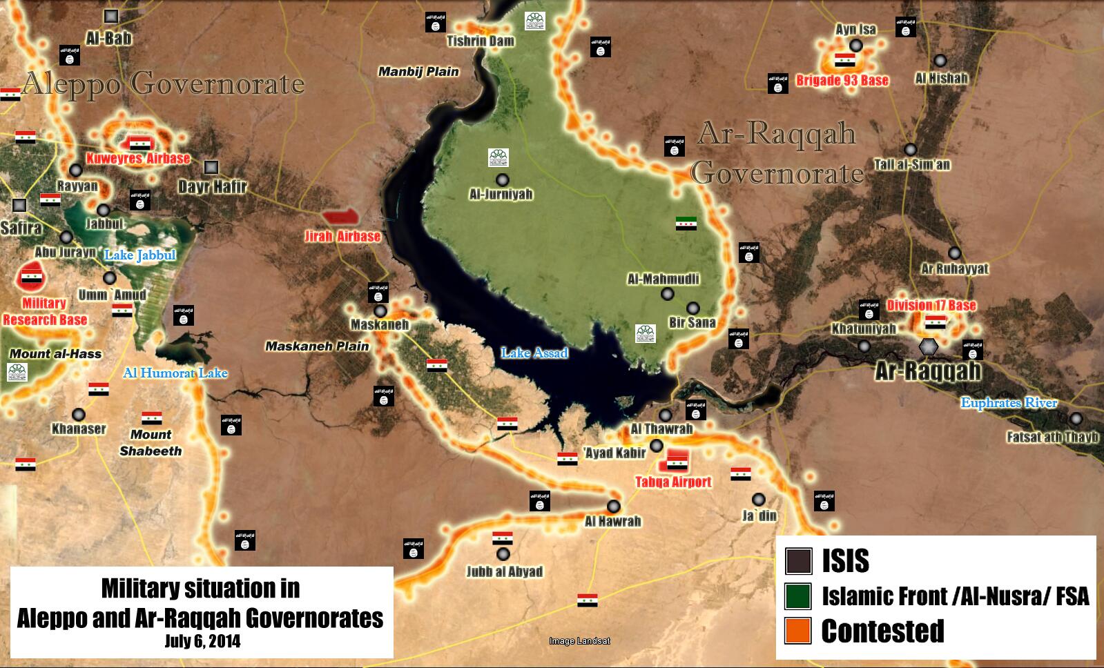
Ayyash is in Army control edit
Since July 19 it's in full Army control (10+ Sources + visual evidences) I no found solid evidences IS get there atm [[23]] --Pototo1 (talk) 13:33, 15 August 2014 (UTC)
A barnstar for you! edit

|
The Guidance Barnstar | |
| For all your help in keeping the maps updated. Your constant diligence keeps them accurate! MrPenguin20 (talk) 14:09, 16 August 2014 (UTC) |
ISIS-controlled Eastern Hama edit
I think we should change the towns in east Hama on these maps to ISIS-controlled or contested since these three sources [24][25][26] are all consistent on this point. One is SOHR (all agreed it is highly reliable), Desyracuse (slightly pro-opp), Archicivilians (heavily pro-opp, not always reliable). However, again, they have all been consistent on this point that ISIS controls at least a part of this area. These are the propositions:
Abu Hanaya and Akash - contested
Salba, Masadah, Masoud, Mukayman al-Shamali, Abu Dali, Abu Ramal, Soha, Grouh and Jinn Albawi - ISIS-held
That's it. P.S. Grouh is off a bit on our map. It needs adjusting. EkoGraf (talk) 04:16, 22 August 2014 (UTC)
- Both maps how we know are pro opposition. Also SOHR as we know from many sources opposes to Syrian government even though we agreed to use it. But we need confirmation that IS captured so many villages but not one of the reliable sources not said for this. I think that all the same, we need to confirmation these data from other reliable sources. Hanibal911 (talk) 05:31, 22 August 2014 (UTC)
- We all agreed to use SOHR as the most authoritative source. And we have SOHR confirming that sub-district is ISIS-held. Not to mention the reliable sources you mentioned (like AFP, AP, Reuters, etc) are all actually using information from SOHR most of the time. P.S. There are no pro-government sources countering the claims about this area. EkoGraf (talk) 05:37, 22 August 2014 (UTC)
- I stumbled on by chance just a minute ago a pro-government news source [27] that is showing a map where the area in question is highlighted. EkoGraf (talk) 05:45, 22 August 2014 (UTC)
- Right now, I have edited the map. So what do I do to change they villages on under control IS or not. Hanibal911 (talk) 05:52, 22 August 2014 (UTC)
- Like I said above. Abu Hanaya and Akash contested, the rest ISIS-held. EkoGraf (talk) 06:32, 22 August 2014 (UTC)
- If you look closely at the Al Jazeera map [28] you will see the area in question also marked as a support zone, again giving credence to the notion they are in control there. I cann't read the New York times because I'm over my limit for this month. But again, SOHR said they control that sub-district. EkoGraf (talk) 16:39, 22 August 2014 (UTC)
- Like I said above. Abu Hanaya and Akash contested, the rest ISIS-held. EkoGraf (talk) 06:32, 22 August 2014 (UTC)
- Right now, I have edited the map. So what do I do to change they villages on under control IS or not. Hanibal911 (talk) 05:52, 22 August 2014 (UTC)
- I stumbled on by chance just a minute ago a pro-government news source [27] that is showing a map where the area in question is highlighted. EkoGraf (talk) 05:45, 22 August 2014 (UTC)
- We all agreed to use SOHR as the most authoritative source. And we have SOHR confirming that sub-district is ISIS-held. Not to mention the reliable sources you mentioned (like AFP, AP, Reuters, etc) are all actually using information from SOHR most of the time. P.S. There are no pro-government sources countering the claims about this area. EkoGraf (talk) 05:37, 22 August 2014 (UTC)
Bait tima edit
Bait tima was added as contested via SOHR.so please self-revert or tell someone else to do so please.Alhanuty (talk) 20:01, 22 August 2014 (UTC)
Hey edit
Hey do me a favor and undo my last edit please - the Tabqa Airbase one - I am having trouble reverting it. 19:24, 23 August 2014 (UTC)Boredwhytekid (talk)
A barnstar for you! edit
|
|
The Original Barnstar |
| For your efforts on the Syrian and Iraqi maps and also showing sources that are reliable for that edit(s). Damirgraffiti |☺Say Yo to Me!☺ 00:30, 27 August 2014 (UTC) |
Barnstar edit
Thank you very much! :) EkoGraf (talk) 19:57, 30 August 2014 (UTC)
Reliable Source edit
OK, I didn't realise that was a pro-opposition source. This, however: https://docs.google.com/file/d/0ByQl9HGZDeRXbmdkSnRQVDd3Nm8/edit isn't a pro-opposition source — Preceding unsigned comment added by Jafar Saeed (talk • contribs) 18:24, 4 September 2014 (UTC)
Opposition sources edit
I guess that the map from https://pietervanostaeyen.files.wordpress.com/2014/09/2000px-syria6.png are too coarse to gain intelligence about single villages. Furthrmore he is unlikely to have any more detailed info that we have. On the other hand the map from pro-government source is precise and reliable. If any, we should push for having them accepted for all changes, as we did for SOHR. Paolowalter (talk) 20:35, 4 September 2014 (UTC) Paolowalter (talk) 20:35, 4 September 2014 (UTC)
Reliable Source edit
I guess that the map https://pbs.twimg.com/media/Bw2v9IIIIAAHoPf.jpg:large is a puzzle of other maps. No original information is available. It follows quite closely our map with a few points of difference. It would bring no significant changes anyway.Paolowalter (talk) 20:04, 6 September 2014 (UTC)
Why is @deSyracuse not a reliable source edit
Why is @deSyracuse not a reliable source? — Preceding unsigned comment added by Jafar Saeed (talk • contribs) 20:26, 8 September 2014 (UTC)
- I sent you a reply on your talk page! Hanibal911 (talk) 20:31, 8 September 2014 (UTC)
Yellow circle south of Petrovske, west of Ivanivka and east of Hrushove was added again in the map edit
Yet, there are only 2 villages there - Urozhaine (Урожайне in Ukrainian, Урожайное in Russian) and Tamara (Тамара in Ukrainian and in Russian). Even http://liveuamap.com/ displays that circle as red (controlled by the insurgents). Do you have any information that those 2 villages are being sieged or something like that?? - see map [29] (Ukrainian) / [30] (Russian) / [31] (English) Mondolkiri1 (talk) 02:03, 9 September 2014 (UTC)
SOHR edit
This was discussed multiple times in the past. Even though they are a pro-opposition source and their rethoric can be heavily anti-government, their battlefield reports (reporting advances and defeats of both ides) have shown to be highly reliable and for the most part neutral in the past and are used by the international reliable media outlets who describe SOHR authoritative on the issue. EkoGraf (talk) 09:33, 12 September 2014 (UTC)
- Maybe you are right! Hanibal911 (talk) 13:42, 12 September 2014 (UTC)
Need help edit
can you revert Paolowalter's last edit on the Module.Alhanuty (talk) 19:08, 14 September 2014 (UTC)
Kobani villages under IS control edit
via this source,these villages has been captured by IS,so can you update the map.http://www.alkurdiya.net/2014/09/blog-post_231.html.Alhanuty (talk) 22:45, 17 September 2014 (UTC)
Concerning to the War in Donbass and Russian military intervention maps edit
I've written to you:
- @Hanibal911: I asked you about Zolote, Hirs'ke and Stanytsia Luhanska, concerning to the source you've provided to paint Pervomaisk in red again: are Zolote, Hirs'ke and Stanytsia Luhanska also occupied by the insurgents? And, by the way (at least for me), you don't need to refer to the rebels as the evil ones against the good ones. I'm neutral and I think both sides have antagonist, though legitimate positions about the issue. You didn't answer to me about the question I posed to you! Unless you can provide me a consistent answer answer about Zolote, Hirs'ke and Stanytsia Luhanska, I'll be quite blind about the situation in these 3 towns. Because I translated the sources in Google Translator and Paralink translator (I'm a Portuguese (latin) with a good knowledge of English and Spanish and some knowledge about Italian and French). Pervomaisk, by what I've understood, is in the same situation of Zolote, Hirs'ke (or is it another place?) and Stanytsia Luhanska. I have to be consistent in the maps that I edit from the sources you provide to me (and others that I get). So far, I've only kept Pervomaisk as red, but according to your source, if I'm not wrong, at least Zolote and Stanytsia Luhanska should also be red. Only after you (or someone else) reply to this question (preferably with more sources about Pervomaisk, Zolote and Stanytsia Luhanska), I will do a later update about the other sources you provided to me. I have to be accurate according to the sources that are provided and I update the map according to them, if they seem to be reliable enough, taking into account the "fog of war". I'll quote this answer in both maps involved Mondolkiri1 (talk) 04:27, 18 September 2014(UTC)
AND:
- @Hanibal911: OK, I'm not going to quote this yet, since it could provoke an unnecessary confusion and some bad-faith editors could turn against you because of this. But, please, please, please, clarify me first about Zolote, Stanytsia Luhanska and (if I understood well) Hirs'ke!Mondolkiri1 (talk) 04:53, 18 September 2014 (UTC)
I'd be glad if you could clarify these issues to me, because I have to rely on online translations from Ukrainian and Russian and they're not always accurate.Mondolkiri1 (talk) 04:56, 18 September 2014 (UTC).
About the map edit
I've already reached 3 reverts, so today I can't revert it anymore. According to the sources you've provided to me and according to http://liveuamap.com/ (the official ATO site of Ukraine), correct the map if you think it's appropriate, providing sources, please! Today, I can't do anything else. Mondolkiri1 (talk) 13:14, 18 September 2014 (UTC)
Rumeilan oil fields edit
Hi, sorry for the enormous delay on this one, you know, summer is a difficult time for editing WP, hehe... Here you have wich I consider the most appropiate location of Rumeilan oil fields, if you want to add it to the map. Regards,--HCPUNXKID 14:02, 18 September 2014 (UTC)
village in Hama edit
The video about the capture was uploaded to youtube late on 18 September, despite it being dated as 19 September. So it was most likely filmed after the capture on 17 September as reported by SOHR. EkoGraf (talk) 22:25, 20 September 2014 (UTC)
Nemer, Namer, Nimer! edit
SOHR reports barrel bombing of "Nemer". This Nimer is on our map, SAA held. This Namer is not on our map. Both towns are on the front line, so I do not know which one is contested! Any ideas? Boredwhytekid (talk) 16:36, 26 September 2014 (UTC)
- SOHR clear said about two towns of al Na’emeh and Nemer. SOHR not said about Al Nimr.SOHR Hanibal911 (talk) 17:49, 26 September 2014 (UTC)
Infobox (again) edit
Didn't we discuss this before? Fitzcarmalan (talk) 22:37, 28 September 2014 (UTC)
Rif Dimashq edit
Just started to read the neews. I only saw, except for your source, Peto Lucem quoting government sources that they are advancing towards Duma. At the very least Tal-al-Kurdy needs to be marked as contested while Al-Suwan as government held. EkoGraf (talk) 12:32, 29 September 2014 (UTC)
- Thanks for the answer! Hanibal911 (talk) 12:36, 29 September 2014 (UTC)
Ablu Aitha / Albu Aath edit
Hey! I am trying to locate "Albu Aitha, north of Ramadi" as mentioned in ISW report, which states that IS is besieging 240+ ISF troops there. This location is listed as "Albu Aath" on mapcarta. What do you think? Same place? Boredwhytekid (talk) 13:43, 30 September 2014 (UTC)
Barnstar edit

|
The Detective Barnstar | |
| In appreciation of your very valuable contributions concerning to providing a wide range of sources about the military situation in the War in Donbass and 2014 Russian military intervention in Ukraine, which have been of the utmost importance for updating the maps concerning to them! Mondolkiri1 (talk) 22:32, 1 October 2014 (UTC) |
Mondolkiri1 (talk) 21:32, 1 October 2014 (UTC)
As I replied to you in my Wikimedia Commons' talk page (waiting for an answer) edit
- Do you have a source about Starohnativka?. The source you gave to me ([32]) talks about Schastya, Popasna, Slavianosebersk, Avdiivka, Marinka, Maiorska and Volnovakha (and in the Donetsk Airport and Debaltseve area), not Starohnahnativka. Is it in the map?
- Is Kurakhove still contested? There have been some weeks when I haven't heard anything about it!Mondolkiri1 (talk) 21:44, 1 October 2014 (UTC)
Samlin and Inkhil edit
via multiple sources,the towns are bombarded heavily https://www.facebook.com/syriahroe/posts/590837797691229 https://www.facebook.com/syriahroe/posts/590465967728412 https://www.facebook.com/syriahroe/posts/590434211064921 https://www.facebook.com/syriahroe/posts/590324227742586 https://www.facebook.com/syriahroe/posts/591546840953658 https://www.facebook.com/syriahroe/posts/591396717635337 http://syriahr.com/en/2014/10/23-soldiers-from-the-regime-forces-died-in-daraa/ https://www.facebook.com/syriahroe/posts/591117634329912 https://www.facebook.com/syriahroe/posts/591033547671654 https://www.facebook.com/syriahroe/posts/590863937688615 https://www.facebook.com/syriahroe/posts/591964154245260 .Alhanuty (talk) 14:48, 4 October 2014 (UTC)
Discussion at the Village Pump edit
Hello! This message is to notify you that there is a discussion at the Wikipedia Village Pump that may be of interest to you. -Kudzu1 (talk) 17:48, 5 October 2014 (UTC)
Aranews edit
Aranews is not pro-opposition,it is a pro-kurdish source,so it doesn't break the rule.Alhanuty (talk) 06:55, 6 October 2014 (UTC)
Blocked from editing edit

Reminder to administrators: Community sanctions are enacted by the consensus of the community. You must either discuss this block with the blocking administrator and receive their approval, or receive consensus at a community noticeboard before reversing this block.
Hanibal911 (block log • active blocks • global blocks • contribs • deleted contribs • filter log • creation log • change block settings • unblock • checkuser (log))
Request reason:
I believe that my block is not justified because according the rule 1RR I can not revert the editing which make other editor without good reason. In this case here I not revert editing because I just edit map and provide source which confirm my editing. In these both cases,herehere editings have been made not justified because the sources that were provided not confirm editings which were made and I only edited this Module in accordance with the data from these sources and not just take and revert editings which were made by other editors. So I did not break a rule 1RR. Also in this module Syrian Civil War detailed map was a warning that we can not revert editings which were made by other editors without provide reason which justifies such action.
Decline reason:
It is not clear why you think reverting good faith changes from other editors is exempt from 1RR. The message above seems to be claiming that you feel your edits are correct, therefore exempt from the sanctions; this is not the case. Kuru (talk) 11:33, 6 October 2014 (UTC)
If you want to make any further unblock requests, please read the guide to appealing blocks first, then use the {{unblock}} template again. If you make too many unconvincing or disruptive unblock requests, you may be prevented from editing this page until your block has expired. Do not remove this unblock review while you are blocked.
Opposition claim of town takeover edit
Got it on the opposition claim. I will revert him and note its an opposition claim. EkoGraf (talk) 15:18, 6 October 2014 (UTC)
al-Adnania edit
- Boredwhytekid So, according to SOHR clashes continue between the two sides around village al-Adnania not inside the village. Regards! Hanibal911 (talk) 15:24, 8 October 2014 (UTC)
![]() Done Boredwhytekid (talk) 15:32, 8 October 2014 (UTC)
Done Boredwhytekid (talk) 15:32, 8 October 2014 (UTC)
I just changed Adnania back to contested. Here's why: SOHR says clashes "in" Safirah. I think this city is too big and strategically important to make contested based on 1 report! So I put lime circle to the SW, and changed Adnania to contested because rebels must have gone through there, but there is no confirmation of who controls it. I think this is suitable until more information about the front line is available. Boredwhytekid (talk) 18:21, 8 October 2014 (UTC)
- BoredwhytekidThere's probably a typo because the same source says that rebels “strike three sites of the army which are al Adnaneyyi, al Zera’ah al Foqaneyyi and al Zera’ah al Tehtaneyyi in order to open a road to attack the Defense Factories. Also SOHR said that if rebels take control of these factories this led to besiege the regime forces inside the town of al Sfireh, So does this mean that there is no clashes in the city or its suburbs and the rebels only shelled from artillery the outskirts of the city Al Safira (al Adnaneyyi, al Zera’ah al Foqaneyyi and al Zera’ah al Tehtaneyyi) So I think it may be noted the village Al Adnaneyyi for now as besieged. Also as long as there is no evidence from other reliable sources about the advances of the rebels and the capture of territory in this area. This information was originally published in the pro opposition source.Sln News www.syriadirect.org/rss/1600-syria-direct-news-update-10-8-14 Hanibal911 (talk) 19:37, 8 October 2014 (UTC)
Maybe you are right. SOHR is reporting clashes in Adnaneyyi though. In any case - I threw the whole topic up on the talk page for further discussion. Boredwhytekid (talk) 20:08, 8 October 2014 (UTC)
- Jafar SaeedThere's probably a typo because the same source says that rebels “strike three sites of the army which are al Adnaneyyi, al Zera’ah al Foqaneyyi and al Zera’ah al Tehtaneyyi in order to open a road to attack the Defense Factories. Also SOHR said that if rebels take control of these factories this led to besiege the regime forces inside the town of al Sfireh, So does this mean that there is no clashes in the city or its suburbs and the rebels only shelled from artillery the outskirts of the city Al Safira (al Adnaneyyi, al Zera’ah al Foqaneyyi and al Zera’ah al Tehtaneyyi) Also as long as there is no evidence from other reliable sources about the advances of the rebels and the capture of territory in this area. This information was originally published in the pro opposition source.Sln News www.syriadirect.org/rss/1600-syria-direct-news-update-10-8-14 Hanibal911 (talk) 05:25, 9 October 2014 (UTC)
- BoredwhytekidSOHR reported that YPG fighters took control over Tall Shair which located in the western countryside of city Kobane.here Hanibal911 (talk) 05:36, 9 October 2014 (UTC)
 Done Boredwhytekid (talk) 12:23, 9 October 2014 (UTC)
- Boredwhytekid You can correct the mistake! Because SOHR said that clashes taking place between regime forces and Islamic battalions in JAdia area but not said that clashes inside city Judayyah.here But Alhanuty probably not carefully read the source and noted it as a contested. Hanibal911 (talk) 06:49, 10 October 2014 (UTC)
- Judayyah, Simlin, Nimer. Geez oh man. Boredwhytekid (talk) 12:57, 10 October 2014 (UTC)
- Boredwhytekid I apologize in advance that may be I often bothering you with my requests, but I can see that you also trying to do everything that would the map reflects the real situation. So maybe you can help me to fix not justified change which was make without identifying the source. here Hanibal911 (talk) 17:59, 10 October 2014 (UTC)
- Keep 'em coming. I am trying but cannot keep up/do not have enough reverts! Boredwhytekid (talk) 18:23, 10 October 2014 (UTC)
- BoredwhytekidAlso you can restore this my editing here which had previously been reverted the editor Cobanas but without a valid reason on this although I have provided the pro opposition source of Ara News which confirmed my editing!source Hanibal911 (talk) 19:44, 10 October 2014 (UTC)
![]() Done An addition - I placed a yellow ring around Ja'zah per the same source - "This coincided with clashes between the Kurdish forces of the Popular Protection Units (YPG) –military arm of the Democratic Union Party PYD– and IS militants in Jazaa area near the Syrian-Iraqi border" Boredwhytekid (talk) 20:02, 10 October 2014 (UTC)
Done An addition - I placed a yellow ring around Ja'zah per the same source - "This coincided with clashes between the Kurdish forces of the Popular Protection Units (YPG) –military arm of the Democratic Union Party PYD– and IS militants in Jazaa area near the Syrian-Iraqi border" Boredwhytekid (talk) 20:02, 10 October 2014 (UTC)
- Boredwhytekid You can fix a mistake which do Alhanuty because he put green circle around the town Kanaker but SOHR clear that the regular forces bombarded Kankar town outskirts and another areas in al-Tayba town. But Sohr not said about clashes around or near the town Kanaker.source And why he change size of the town Kanaker and noted him how just village.here His actions are harm the map! Hanibal911 (talk) 16:24, 11 October 2014 (UTC)
- Boredwhytekid SOHR reported that regime forces have regained control on villages after losing it in the battle of ” Za’er al-Ahrar ” against Ahrar al-Sham movement.source Hanibal911 (talk) 14:08, 12 October 2014 (UTC)
- Boredwhytekid Sorry to bother you but maybe you manage find on the map these villages (al Wehdah al Da’emah and Masaken al Shabab )in the southern countryside of al Hasaka about which reported by SOHR.source Hanibal911 (talk) 15:51, 12 October 2014 (UTC)
- village Ma'rkaba in the northern Hama countryside under control by regime troops.SOHR Hanibal911 (talk) 10:51, 13 October 2014 (UTC)
- Boredwhytekid Sorry to bother you but maybe you manage find on the map these villages (al Wehdah al Da’emah and Masaken al Shabab )in the southern countryside of al Hasaka about which reported by SOHR.source Hanibal911 (talk) 15:51, 12 October 2014 (UTC)
- Boredwhytekid SOHR reported that regime forces have regained control on villages after losing it in the battle of ” Za’er al-Ahrar ” against Ahrar al-Sham movement.source Hanibal911 (talk) 14:08, 12 October 2014 (UTC)
- lol those are some questionable edits! the Ma'rkaba source just says rebels bombarded it, right? and the Aleppo source does not specify which villages have been retaken! But, both of those edits have already been taken care of anyway. I'll look for al Wehdah al Da'emah and Masaken al Shabab. Boredwhytekid (talk) 12:51, 13 October 2014 (UTC)
- BoredwhytekidBut SOHR clear said that Islamic fighters targeted with shells regime bastions in Ma'rkaba village.here Also pro opposition source confirmed that rebels retreated from the villages Abu Tabbah, Sad'aya, Qashuta, Bashquy, Diman, Zira'ah, Adnania.herehere Also how you can see I try not to publish unconfirmed data. Hanibal911 (talk) 13:55, 13 October 2014 (UTC)
- Boredwhytekid Here new confirmation about situation in the city Al Harra in Dara province. Iranian source clearly said that rebel forces in Daraa have seized the town of al-Harrah.Mehr Iran TV Hanibal911 (talk) 14:07, 13 October 2014 (UTC)
- BoredwhytekidBut you are wrong when you noted the city Nimr under control the rebels. Because SOHR not said that rebels seized this city. Also SOHR did not elaborate on what exactly the city in question.here But in the situation with the city Ma'rkaba SOHR clear said that Islamic fighters targeted with shells regime bastions in the village Ma'rkaba.here Hanibal911 (talk) 14:27, 13 October 2014 (UTC)
- Boredwhytekid Here new confirmation about situation in the city Al Harra in Dara province. Iranian source clearly said that rebel forces in Daraa have seized the town of al-Harrah.Mehr Iran TV Hanibal911 (talk) 14:07, 13 October 2014 (UTC)
- BoredwhytekidBut SOHR clear said that Islamic fighters targeted with shells regime bastions in Ma'rkaba village.here Also pro opposition source confirmed that rebels retreated from the villages Abu Tabbah, Sad'aya, Qashuta, Bashquy, Diman, Zira'ah, Adnania.herehere Also how you can see I try not to publish unconfirmed data. Hanibal911 (talk) 13:55, 13 October 2014 (UTC)
That Iranian TV source is a diamond in the rough! What an argument that's been. True, SOHR didn't specifically say rebels are in Nimr, but, it's so far behind rebel lines (especially since Harrah is confirmed rebel held). And Nimr is too small for the SAA to bombard it if they have troops inside still. Boredwhytekid (talk) 14:45, 13 October 2014 (UTC)
- BoredwhytekidYet SOHR not said that the city Nimr under rebel control, and I think that at the moment the best solution is to mark it as a contested. Also some activists reported about violent clashes in Tal al- Harra between the SAA and Jabhat Al-Nusra.herehere Although I do not quite trust to these sources but maybe you have more information on this subject. Hanibal911 (talk) 15:08, 13 October 2014 (UTC)
- I think Nimr is pretty obviously rebel-held. But, I do not have a source to 100% confirm that, and what you suggest is a fair and reasonable compromise. I will make Nimr contested. Let's revisit Nimr in a week or so if reports of bombardment continue but no reports of clashes surface. Boredwhytekid (talk) 15:22, 13 October 2014 (UTC)
- Boredwhytekid OK! Also you can change the size of the circle which marked the city Kanaker because he must be larger (8 but not 6)because Kanaker it is city but no village.
- Here's a table of sizes for cities and villages for displayed on the map:
- Under 5,000 is size 6
- 5000 to 19,999 is size 8
- 20,000 to 49,999 is size 10
- 50,000-99,999 is size 12
- Above 100,000 is size 14 Hanibal911 (talk) 15:36, 13 October 2014 (UTC)
On review, Alhanuty may have been correct (though without sources!) Within the last 30 days pro-gov't farsnews reports clashes in Kanaker, pro-gov't syriatimes says some of the militants of Kanaker surrendered, eaworldview implies that Kanaker is part of the rebel-contested West Ghouta pocket, and that SOHR does say the SAA bombarded its outskirts. Maybe the green concentric circle would be appropriate after all. Boredwhytekid (talk) 18:14, 13 October 2014 (UTC)
- Boredwhytekid But here pro opposition map dated on 8 October which clearly shows that no clashes in the city Kanaker or on its outskirts.here Hanibal911 (talk) 18:24, 13 October 2014 (UTC)
I'm uncertain. pro-gov't media would NEVER give the rebels credit for being somewhere they are not. Boredwhytekid (talk) 18:27, 13 October 2014 (UTC)
- Boredwhytekid Let's at the moment leave it at that but will closely monitor the situation in the area! Hanibal911 (talk) 18:34, 13 October 2014 (UTC)
- BoredwhytekidIn accordance with data from the progovernment map you can add on the map two military objects in the Eastern Ghouta.Air Defense BaseArmy Storage Base Hanibal911 (talk) 06:09, 14 October 2014 (UTC)
- Boredwhytekid I see that you also how and I became a victim of the rule 1RR so that if you have data to edit the map you can sent this data to me. After all, you helped me and now it's my turn to help you. Term of my block expires 16 October at 8:15. Regards! Hanibal911 (talk) 15:52, 14 October 2014 (UTC)
- EkoGraf Heavy clashes between regime forces and Syrian rebels in the Handarat district of the city Aleppo.Reuters Hanibal911 (talk) 19:02, 14 October 2014 (UTC)
- Boredwhytekid I see that you also how and I became a victim of the rule 1RR so that if you have data to edit the map you can sent this data to me. After all, you helped me and now it's my turn to help you. Term of my block expires 16 October at 8:15. Regards! Hanibal911 (talk) 15:52, 14 October 2014 (UTC)
- BoredwhytekidIn accordance with data from the progovernment map you can add on the map two military objects in the Eastern Ghouta.Air Defense BaseArmy Storage Base Hanibal911 (talk) 06:09, 14 October 2014 (UTC)
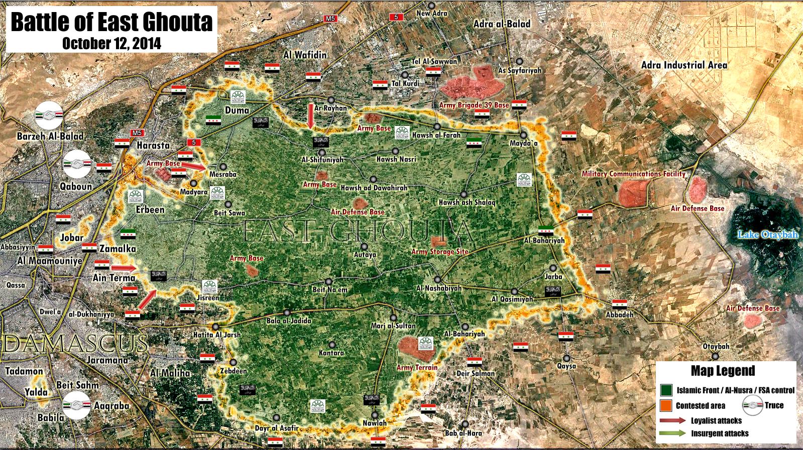
- Done Boredwhytekid (talk) 12:45, 15 October 2014 (UTC)
Iraqi insurgency detailed map edit
Boredwhytekid Can you help me fix the map? Need fix the unjustified editing without identifying the source:here Hanibal911 (talk) 16:54, 8 October 2014 (UTC)
![]() Done I caught and reverted the other 11 unsourced edits that that user made yesterday.. must've missed that one. Thanks! Boredwhytekid (talk) 17:00, 8 October 2014 (UTC)
Done I caught and reverted the other 11 unsourced edits that that user made yesterday.. must've missed that one. Thanks! Boredwhytekid (talk) 17:00, 8 October 2014 (UTC)
- Boredwhytekid Thank you very much for your help! But there is a way to solve the problem of IP vandalism. Request to the admins about protection.Requests for page protection This will solve the problem! Hanibal911 (talk) 17:15, 8 October 2014 (UTC)
That is a good suggestion. If that IP continues to vandalize I will request protection for the page Boredwhytekid (talk) 18:18, 8 October 2014 (UTC)
- Boredwhytekid The reliable sources said that the town Baiji under control by Iraqi army.NaharnetNDTVSBS NewsKhaleej TimesThe Malaysian Insider Hanibal911 (talk) 17:22, 12 October 2014 (UTC)
- Boredwhytekid So what do you think about the information about the city Baiji. Hanibal911 (talk) 15:43, 13 October 2014 (UTC)
![]() Done Boredwhytekid (talk) 15:53, 13 October 2014 (UTC)
Done Boredwhytekid (talk) 15:53, 13 October 2014 (UTC)
- Boredwhytekid Today around 300 government forces retreat from the military camp which located outside the city of Hit and join to other forces which holed up at Asad air base to deeper in the desert.Naharnet You do not know what kind of a military camp. Also according this source the Iraqi town not under control IS only parts of this town. Help me fix a map! Hanibal911 (talk) 17:16, 13 October 2014 (UTC)
I removed the red presence in Hit based off of Daily Star, what says "Iraqi government troops stationed on the edge of Hit in beleaguered Anbar province have withdrawn to another base, leaving the city under full jihadist control, security sources said Monday." Daily Star just issued another report about it too. I believe the Hit Training Camp is here. Boredwhytekid (talk) 17:48, 13 October 2014 (UTC)
- Boredwhytekid You are right! Also you can change the town of Ramadi on contested.Naharnet Hanibal911 (talk) 18:14, 13 October 2014 (UTC)
![]() Done Boredwhytekid (talk) 12:51, 15 October 2014 (UTC)
Done Boredwhytekid (talk) 12:51, 15 October 2014 (UTC)
What do you think about this source? It links to lots of Arabic news source, and I think it could be helpful in updating the Iraq Module (which is in serious need of updates) Boredwhytekid (talk) 17:53, 15 October 2014 (UTC)
- Boredwhytekid Absolutely agree with you. I think that for update of this module it is great source. Hanibal911 (talk) 18:12, 15 October 2014 (UTC)
Hey guys edit
Hanibal911, EkoGraf, you two and myself do the majority of edits on Module Syrian Civil War detailed map - hence I'm reaching out to you two. We don't always agree, we downright argue sometimes, but I think overall the map benefits from our combined attention. Is there any recourse we can take to somehow stem the tide of unsourced edits, argument about using al masdar as a lone source for pro-gov't gain, and argument about using SOHR at all? These are all topics that I'm pretty sure have been agreed upon by the main editors of the page - no unsourced edits without community consensus, no al masdar as a lone source for pro-gov't advances, and SOHR used for all sides, but with a grain of salt and common sense concerning their wording. Nonetheless, vitriolic arguments about al masdar and SOHR happen on a near monthly basis, and unsourced edits (without community consensus) plague the module and demand reverts pretty much daily. I'm still kinda new at this, but doesn't Disruptive Editing come in at some point? Or is there some sort of Dispute Resolution that would be appropriate? Hanibal911, I see that your current block was a result of you making multiple reverts on such disruptive editing - so obviously breaking 1RR is not the solution here. I'm just spit-balling here.. how do we stop POV pushing and disruptive editing generally?
al Masdar as primary source for pro-gov't edit
misrepresentation of information in source
If I'm completely out of line please tell me so. My bad for bothering you two, again - Just getting tired of being hands-tied by 1RR and watching unsourced edits or edits based on community-agreed-upon sources being reverted and substituted for biased sources or misrepresented sources.
- BoredwhytekidYou raised a very important question which I see has long been worried not only me. So I think that the rule 1RR should not apply in the case when we reverted the unjustified editings which were made without specifying the source or when the source that was specified not confirmed this editing or just plain destructive edits or if that provoke war of edits. So sometimes this rule (1RR) prevents fix the map. Hanibal911 (talk) 19:03, 10 October 2014 (UTC)
- This rule should be applied only in the cases when the revert is not justified or if it provokes the war of edits. Otherwise, it will only be to encourage editors who make unjustified changes to continue their destructive actions, and even so deliberately provoke of the other editors which revert this unjustified changes. Knowing full well that these editors will be blocked for violation of the rules 1RR. And after that they will be able to freely make unjustified changes knowing that no one can stop them. Hanibal911 (talk) 19:26, 10 October 2014 (UTC)
Seriously the usage of Al-Masdar to report Government advance has gone over the limits.Alhanuty (talk) 22:34, 13 October 2014 (UTC)
- Alhanuty In our discussion, we have clearly shown that we are against the use of a source of Al Masdar to display the progress of the army. Hanibal911 (talk) 05:58, 14 October 2014 (UTC)
problem is editors Paolowalter and pototo and another editor still insist on doing so.Alhanuty (talk) 06:01, 14 October 2014 (UTC)
Air Defense "Battalion 602" Base edit
- Tradedia here confirmation from pro opposition map that "Battalion 602" near the village Handarat under control by army. So that need return this base on the map. Hanibal911 (talk) 05:56, 14 October 2014 (UTC)
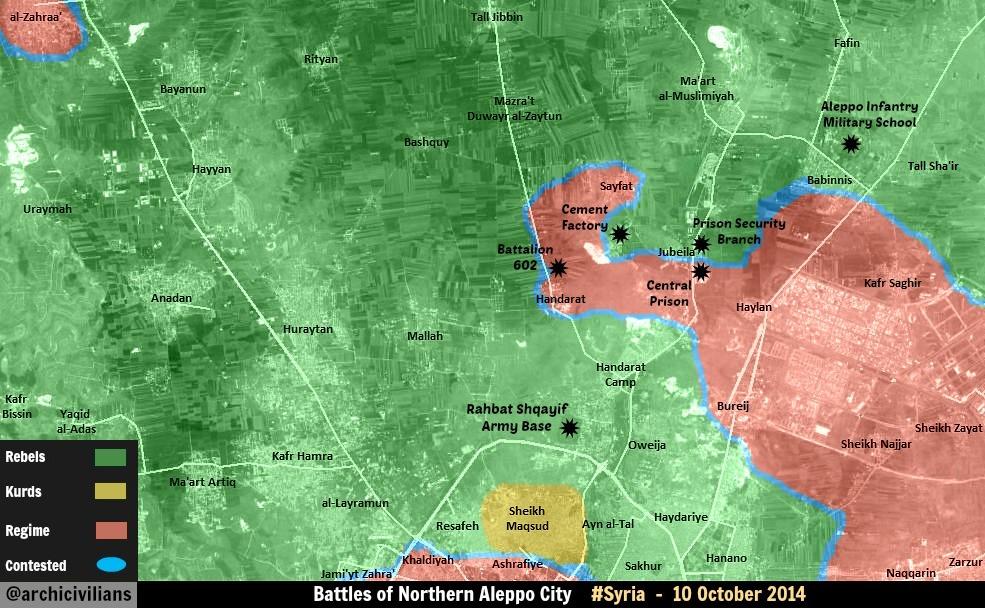
Qunietra edit
I think we filled the al-Adnania section enough. What's your take on this Daily Star article. It says that there are only 4 villages in Qunietra province not overrun by Nusra. The 2 Druze villages mentioned have got to be Turnajah and Hadar; the other two must be Madinet al Ba'ath and Khan Arnabah, right? If true, then it is time to turn those 5 villages behind rebel lines to green (Mamtinah, Rasm Kharrar, al-Hajah, Dwayah, and Rasm al Sayd) Boredwhytekid (talk) 14:52, 15 October 2014 (UTC)
- Boredwhytekid Probably you are right! But let's wait for tomorrow morning and I'll try find more information and if there is no other information about situation it this area then we marked these villages under control by rebel. Just, that would we have been fully confident in the correctness of such a change. Hanibal911 (talk) 15:15, 15 October 2014 (UTC)
Sounds like a plan Boredwhytekid (talk) 18:37, 15 October 2014 (UTC)
- Boredwhytekid I have no other data and we can note these villages under rebel control. So If you also not have other data we can make this change. Hanibal911 (talk) 11:03, 16 October 2014 (UTC)
- Boredwhytekid Also here pro government map dated on 12 September clear show that areas south from the village Majduliyah under rebel control. Hanibal911 (talk) 12:50, 16 October 2014 (UTC)
This al-Monitor article supports these edits too - "The regime lost Quneitra and its countryside weeks ago, and today it is losing its most fortified positions in Daraa" Boredwhytekid (talk) 13:01, 16 October 2014 (UTC)
- Boredwhytekid Done Hanibal911 (talk) 13:04, 16 October 2014 (UTC)
- BoredwhytekidMaybe when Alhanuty mark the city Nawa under control by rebels he made not a big mistake because source said that government forces have left their positions in the vicinity of al-Harra, northwest of Daraa, and in Tal al-Harra. So that based on data from this source Al Monitor we need put under control by rebels the city of Nimr. Because many pro-government and the pro opposition sources indicate that the town of Nawa contested between the army and rebels. The west part of the city under control the rebels but the east part of the city under control the army. Here pro opp map What do you think? Hanibal911 (talk) 16:27, 16 October 2014 (UTC)
- Looks like he has corrected his edit - Nawa contested, Nimr green Boredwhytekid (talk) 17:19, 16 October 2014 (UTC)
Kafr Shams edit
Boredwhytekid I read your comment about the city Kafr Shams on the talk page and you and you are right that needed confirmation from a neutral source. Further here more detailed pro opposition map which clear show that clashes near the city Kafr Shams. And you correctly put the green circle on the west side of this city.Hanibal911 (talk) 18:24, 15 October 2014 (UTC)
Yemen Insurgency detailed map edit
Boredwhytekid I have the question for you ! Maybe you want join to other similar project and help in editing and improving the map (similar to the Iraqi and Syrian).Yemen Insurgency detailed map Hanibal911 (talk) 18:51, 15 October 2014 (UTC)
- Good to have you back! I'm excited to work with you on the Yemen module as well. Let's try to keep the written log up to date on that one; it's kinda fallen behind on the Syrian module. Is there any similar module for the Libyan civil war? I understand a module for Lebanon is being created. Boredwhytekid (talk) 12:13, 16 October 2014 (UTC)
- Boredwhytekid I'm not very interested in the Libyan war, so I do not know whether there is such a module for this conflict. But if you edited the articles about this conflict, and if you will need my help I will try to help you. And I'm sure that soon there will be a module for the conflict in Lebanon because this conflict directly related to the conflict in Syria. Hanibal911 (talk) 12:22, 16 October 2014 (UTC)
- Boredwhytekid The editor Jumada created the Yemen Insurgency detailed map for conflict in Yemen. So if are you interested the conflict in Libya, you can refer to this editor, and may be he will help you to create the such same template and for the Libyan conflict. Hanibal911 (talk) 12:38, 16 October 2014 (UTC)
- Boredwhytekid I'm not very interested in the Libyan war, so I do not know whether there is such a module for this conflict. But if you edited the articles about this conflict, and if you will need my help I will try to help you. And I'm sure that soon there will be a module for the conflict in Lebanon because this conflict directly related to the conflict in Syria. Hanibal911 (talk) 12:22, 16 October 2014 (UTC)
Thanks for the tip. Perhaps I will reach out to him - I'd like to track Libya too, because it, Yemen, Syria, Lebanon, and Iraq are all hotspots of the same regional conflict right now, and I think it'd be a shame to omit Libya Boredwhytekid (talk) 12:45, 16 October 2014 (UTC)
- BoredwhytekidAgree! Hanibal911 (talk) 18:05, 16 October 2014 (UTC)
i don't think we will need a libyan one,because most likely the conflict in Libya will be over soon,and also,we can do the samething for libya as we did in 2011.Alhanuty (talk) 19:23, 17 October 2014 (UTC)
- AlhanutyMaybe you're right! Personally, I cant say anything on this matter as I am not very sign with topic about conflict in this African country. But if there are editors who are familiar with this topic, and they would like to create a similar module so is their choice. Maybe someone from the editors wants show in more detail situation in that country. Just based on the history of other conflicts in Africa and the Middle East we cant be sure when ended this or that military conflict. Hanibal911 (talk) 20:49, 17 October 2014 (UTC)
Constructive proposal edit
Boredwhytekid Alhanuty EkoGraf Tradedia Paolowalter Jafar Saeed Daki122 Dear editors, I want make offer for all us not add the circles around towns or villages on the basis only of a single message from SOHR about the bombing of a neighborhood town or village or clashes in the area or near a town or village. Because it could be attack only hit and run or the source could be mistaken. Let's add circles only in the event if this report about clashes repeated in the short period. Also I think it would be appropriate to add a larger circles in case when the city or village under siege and the smaller circles if clashes go near or around the town or village. I hope we all remember the case with the village of Tal Malid and about some other cases.here I hope for your understanding. Regards! Hanibal911 (talk) 10:30, 18 October 2014 (UTC)
I agree with you on this one as lets remember this is an insurgent war and many of the attacks are hit and run and many times after the first attack we put a circle around the town showing there is a rebel presence around the town but many times rebels are miles from the same town.The Qualamoun region is a perfect example where rebels are fighting government troops in mountains kilometers from the towns of Flita and Assal-al-Ward but we still have green circles near the towns.Many of those attacks come from the Lebanese side of the border and as soon as the rebels run into government checkpoints or a patrol they flee back across the border into the Arsal area.If there is no constant presence on the outskirts of the town like the rebel presence near Kafr Shams or like the government presence near Telbisah then we should not add circles to mark only one report from SOHR which many times uses the name of the town for the area around the town which is not the same as in the Qualamoun areas around the town with the same name are vast as there are only a few towns in the region.Daki122 (talk) 12:53, 18 October 2014 (UTC)
al-Wa’er edit
Boredwhytekid EkoGraf Paolowalter Do you think maybe we should mark this area as contested as there truce broken and now in this area go clashes.SOHR www.syriadirect.org/rss/1616-syria-direct-news-update-10-16-14 Hanibal911 (talk) 10:36, 22 October 2014 (UTC)
I think so. Apparently clashes have been going on for some time.Paolowalter (talk) 12:50, 22 October 2014 (UTC)
Agree Boredwhytekid (talk) 14:43, 22 October 2014 (UTC)
- Done Hanibal911 (talk) 15:16, 22 October 2014 (UTC)
Kobane edit
For now I think we should leave it as it is because the notable name for the event has so far been the Siege of Kobane. EkoGraf (talk) 12:28, 23 October 2014 (UTC)
Template Lebanese Insurgency detailed map edit
I have created a https://en.wikipedia.org/wiki/Template:Lebanese_Insurgency_detailed_map
take a look and check if it needs any repair.Alhanuty (talk) 23:39, 23 October 2014 (UTC)
- AlhanutyOK! And good idea to create the template for the conflict in Lebanon. It will be extremely useful. Hanibal911 (talk) 05:05, 24 October 2014 (UTC)
Front Al Nusra edit
Boredwhytekid EkoGraf Paolowalter HCPUNXKID Alhanuty Daki122 I suggest you to give your opinion in this debate. here Hanibal911 (talk) 13:20, 29 October 2014 (UTC)
Hama edit
the pro-government map,clearly shows the areas as IS-held.Alhanuty (talk) 20:38, 31 October 2014 (UTC)
Nusra/SRF (plus another issue) edit
I would wait a few days to see, because this well may expand yet since it seems Nusra has paired with ISIS now. However, if it does not, we name it ofensive as you said. P.S. I would ask for your opinion on an issue where an editor has already made three reverts of my edits. I warned him he is on the brink of breaching 3RR. Here is his revert of my original edit [33] (tried to insert compromise wording later on [34] that he refused.) Discussion (or the lack of it) is at his talk page [35]. Cheers! EkoGraf (talk) 09:47, 4 November 2014 (UTC)
- EkoGraf Agree! Also I'm did what you asked. Hanibal911 (talk) 12:33, 4 November 2014 (UTC)
- Thank you! EkoGraf (talk) 14:28, 4 November 2014 (UTC)
- I agree it seems the name of the article should be changed to offensive now, but the title you proposed seems to long. Maybe al-Nusra Front offensive (October–November 2014)? EkoGraf (talk) 08:13, 8 November 2014 (UTC)
- EkoGraf Agree! Hanibal911 (talk) 11:16, 8 November 2014 (UTC)
- I agree it seems the name of the article should be changed to offensive now, but the title you proposed seems to long. Maybe al-Nusra Front offensive (October–November 2014)? EkoGraf (talk) 08:13, 8 November 2014 (UTC)
- Thank you! EkoGraf (talk) 14:28, 4 November 2014 (UTC)
Rif Damascus edit
I have been reading some stuff on this pro-regime sites saying about losses for their soldiers in Beit Temah, in an ambush. It looks like said the same. I belive this town is rebel held. Should I edit the map ?DuckZz (talk) 00:57, 8 November 2014 (UTC)
- DuckZz SOHR not said that Beit Temah is under rebel control. And I do not see the confirmation from the pro-government sources. You just sending me the link to the group on Facebook. Understand that before you edit the map you will need to provide a source that can confirm the change but you dont provide source which said that Beit Temah is under rebel control.Hanibal911 (talk) 06:58, 8 November 2014 (UTC)
Nawa edit
Boredwhytekid EkoGraf Paolowalter HCPUNXKID Daki122 I suggest you give your opinion in this debate.Nawa 2 Hanibal911 (talk) 13:17, 9 November 2014 (UTC)
villages in Hasaka edit
- Boredwhytekid EkoGraf Paolowalter HCPUNXKID Daki122 Alhanuty I suggest you give your opinion in this debate.here I need your opinion and maybe your help. Hanibal911 (talk) 10:49, 10 November 2014 (UTC)
Why? edit
Why make this edit? The front line in Latakia was already clear - all those villages are obviously gov't held, being behind gov't front lines. Adding these towns doesn't add any new information to the map at all.. it's just clutter. Boredwhytekid (talk) 13:48, 11 November 2014 (UTC)
- Boredwhytekid Ok! I remove some village which I add that map the would have looked better! Hanibal911 (talk) 14:07, 11 November 2014 (UTC)
The Half-Barnstar of Cooperation edit

|
The Half Barnstar | |
| Awarded for contending, debating, cajoling, cooperating, arguing, and ultimately working with those holding different perspectives on Modules Syrian Civil War and Iraq Insurgency - long overdue Boredwhytekid (talk) 15:06, 12 November 2014 (UTC) |
Boredwhytekid (talk) 15:06, 12 November 2014 (UTC)
- Boredwhytekid Thanks! Hanibal911 (talk) 15:09, 12 November 2014 (UTC)
Mapping the conflict in Syria edit
Here a map of the conflict in Syria from BBC dated on 11 November. It seems that earlier positions ISIS in central Syria were exaggerated. Hanibal911 (talk) 15:15, 12 November 2014 (UTC)
- According to that map, the government does not have stable control of the area between Homs and Yabroud! lol I do not think this is accurate Boredwhytekid (talk) 16:49, 12 November 2014 (UTC)
- Boredwhytekid You know, I also studied the map and think that you are right map from BBC is not very accurate. Hanibal911 (talk) 19:51, 12 November 2014 (UTC)
Sheikh Miskin edit
In my personal opinion I think the town is still contested. From a neutral standpoint its too confusing to tell what's happening so again I would leave it as contested. EkoGraf (talk) 23:15, 12 November 2014 (UTC)
Shaer edit
If that's true why did the battle stopped (according to the wiki page editors) after SAA recaptured ALL wells and companies?
South Aleppo edit
Why are these villages marked as JAN control. Every source is saying that members of Islamic front let the battles, some groups od JAN fighters were involved but not enough to have an argument putting those areas under their control. Should I change the colors to green ?DuckZz (talk) 19:28, 21 November 2014 (UTC)
- DuckZz Because SOHR clear said that Jabhat al-Nusra have taken over villages al-Jaara, Tat, and Aqriba after violent clashes against regime.SOHR Hanibal911 (talk) 19:41, 21 November 2014 (UTC)
Islamic battalions means Islamic front groups, Rebels = FSA groups. I haven't said JAN were not involved but you can clearly read that 5 members of IF died during those clashes. Same groups of Ahrar Al Sham took control of the same villages they lost weeks ago. SOHR clearly doesn't say JAN took the control but JAN and IF, but we can assume JAN only participate during clashes. I can open a discussion on the main talk page.DuckZz (talk) 20:03, 21 November 2014 (UTC)
- DuckZz Understand that we are not edit just based on assumptions. So while we have only the specific data that those villages under the control of Al Nusra. And in this situation we cant use as source to edit a pro-opposition sources.herehere This source biased in side FSA and her allies. And SOHR did not specify what this Islamic battalions they can be allies the Al Nusra. Need more data. Hanibal911 (talk) 20:18, 21 November 2014 (UTC)
Agree as for now. You need to understand the kind of names used by SOHR. They never write Free Syrian army, Islamic front, Syrian Army. They use Rebels for FSA/SRF groups, Islamic battalions for Islamic Front groups, Al Nusra for Al Nusra and Jund Al Aqsa, and Regime for Syrian Army.
- DuckZz SOHR clearly indicates when says about Islamic Front or about other rebel groups. So that as I said earlier we need more data. Also the Lebanese source reported that villages Al djaarh, Tata and Aqraba near defense plants in the southern countryside of Aleppo are still under the control of the army.Al-Ahed News Hanibal911 (talk) 20:39, 21 November 2014 (UTC)
Aranews edit
Aranews is a pro-kurdish source,and this source is reporting an ISIS gain,and YPG/Regime and ISIS are enemies,so self-revert.Alhanuty (talk) 16:11, 22 November 2014 (UTC)
Nawa edit
Any logic putting this town under JAN control in this way ? There is sense for Khan Sheykun as Al Nusra there has a dominant presence but south Syria is mainly under either FSA or IF control, there are only few Al Nusra groups operating in Nawa. Not a significant presence, would be the same as making a new color for Islamic Front because they have a larger number of fighters in Nawa than Nusra.DuckZz (talk) 19:24, 23 November 2014 (UTC)
- DuckZz Khan Sheykun was marked as under the joint control the rebels and Al Nusra as a compromise, although reliable sourcr clear said that city Khan Shaykhoun it is main stronghold of Jabhat al-Nusra in Idlib province.here here And someone of editors also marked Nawa as under the joint control the rebels and Al Nusra. Perhaps on the grounds that reliable source said that Syrian rebels and Al Nusra fighters seized the southern town of Nawa.The Daily Star Although I do not think that city Nawa should be marked as under the joint control the rebels and Al Nusra. Hanibal911 (talk) 19:59, 23 November 2014 (UTC)
Nawa as many others Towns is with Al Qaeda elements there sharing the control with others irregular armed groups.
- http://news.yahoo.com/syria-rebels-qaeda-capture-key-southern-town-monitor-193046956.html
- http://www.al-monitor.com/pulse/afp/2014/11/syria-conflict-clashes.html
- http://www.skynews.com.au/news/top-stories/2014/11/10/syria-rebels-and-al-qaeda-capture-key-town.html
Sources in Spanish =
- http://www.caracol.com.co/noticias/internacionales/filial-de-al-qaeda-en-siria-arrebata-al-regimen-una-localidad-meridional/20141109/nota/2499577.aspx
- http://eltiempo.com.ve/mundo/violencia/combatientes-del-frente-al-nusra-filial-de-al-qaeda-en-siria-y-de-varias-milicias-rebeldes-e-islamistas-arrebataron-hoy-al-regimen-sirio-la-localidad-meridional-de-nawa-informo-el-observatorio-sirio-de-derechos-humanus/161529 --Pototo1 (talk) 17:14, 26 November 2014 (UTC)
- Pototo1 OK! In this issue, I absolutely agree with you. Hanibal911 (talk) 20:18, 26 November 2014 (UTC)
Green Circles in Al-Jebbah and Ras al-Maraa should be removed edit
Green Circles in Al-Jebbah and Ras al-Maraa in Qalamoun should be removed these places are not besieges https://pbs.twimg.com/media/Bu6MGKyIEAA46Ji.jpg
Insurgents are too weak there. --Pototo1 (talk) 17:03, 26 November 2014 (UTC)
- Pototo1 I understand what you are up against those marks near of some villages but and you must understand what they in currently justified. Because now rebels presented near these villages and green icons show this. Also many reliable sources confirm this but furthermore the map which you are have provided is obsolete and also this is map is pro government and for this reason we cant use her to display the success by army. Hanibal911 (talk) 20:15, 26 November 2014 (UTC)
Lucem maps are the most accurate who you can found his maps always are 100% right and no exist a single source who prove the insurgents blocked the west way in these places
Link something saying Al-Jebbah and Ras al-Maraa are blocked in the west by the insurgent Borekid is just doing vandalism.
This is just stupid so we can all the greens towns in Homs besieges by the Army, same case with greens towns in North of Hama ............ --Pototo1 (talk) 21:40, 26 November 2014 (UTC)
- Pototo1 Over time, the situation will be clarified and perhaps we be able to remove those icons which marked near villages in Qalamoun. But if you again remove them on the basis just of outdated map you again provoke war of edits and some one of admins will be forced again blocked you. So I propose for you let's wait some time. Regards! Hanibal911 (talk) 22:06, 26 November 2014 (UTC)
But why we should keep these circles there when this information is totally incorrect and wrong ?
Why we need keep incorrect info on the map just because some users are crying ?
There no need to be any war of edits because that's the true they no have any single source saying these two towns are blocked in west side.
If they no showing any single source these circles must be remove --Pototo1 (talk) 10:05, 28 November 2014 (UTC)
- Pototo1 These marks show that in this area still there are rebels and periodically occur clashes near these villages.here Hanibal911 (talk) 12:15, 28 November 2014 (UTC)
Russian casualties in Ukraine edit
Your take on this issue [36] would be appreciated. Thanks! EkoGraf (talk) 05:51, 28 November 2014 (UTC)
Idlib edit
This video, altought opposition, says that Al Nusra is allowed to enter the city of Marat Hurmah, what means the town is rebel held. Same thing is said by the guy in the video. I belive that more cities are rebel held in Idlib despite the JAN vs Rebels propaganda online. We can only say for sure that they are at war with SRF front rebel group and that's about it. I belive Marat numan and Kafranbel are also rebels held. The first city is full of opposition groups like Div13, Corps5, Hawk Brigade, Kataib Shamal etc ...DuckZz (talk) 17:06, 29 November 2014 (UTC)
- DuckZz I even dont know what to tell you. For now the city is marked under the control of Al Nusra. Because previously reliable sources confirmed that Al Nusra and its allies seized all the towns and villages in the Jabal al-Zawiya which earlier was under control of some rebel groups associated with FSA.BBCAl Monitor Also we cant use the data from opposition amateur video from YouTube as source to show the success of the rebels. but I still keep track of this issue. And if appear are new data I display this on map.here Hanibal911 (talk) 18:51, 29 November 2014 (UTC)
- I agree with DuckZz on this, since the various sources generally presented the SRF as the only FSA group in Idlib, which is far from true. The SRF was the largest FSA group in Idlib, but not the best armed, and certainly not the best organized. Its' leader was not a military professional, unlike the leaders of other FSA groups there.
- To me a critical reading of this is describing a situation that parallels that of the ISIS in Raqqa before they attacked al-Nusra. In al-Raqqa, remnants of FSA groups joined al-Nusra for protection, and it is only later, after the FSA and IF attacked the ISIS in other provinces that the ISIS regrouped in Raqqa and defeated al-Nusra in the capital city there, and later the province.
- In Idlib, the FSA forces are regrouping in larger groups, in cooperation with most Islamic Front groups, to try to prevent a repeat of Raqqa. I'm certain that most reporting has grossly exaggerated al-Nusra control to date, incorrectly taking al-Nusra presence as control. André437 (talk) 07:21, 30 November 2014 (UTC)
Villages in Idlib edit
Mate can you find and add these villages in the syrian war map beacause i am not rly good with this stuff 2 are captured by SAA and 3 are captured by al-nusra. hereLindi29 (talk) 23:38, 29 November 2014 (UTC)
New icon for Qalamoun ? edit
First, I see you have quite an impressive talk page. Nice :)
I really like the idea of better indicating a rebel presence in the Qalamoun.
A few days ago I saw a suggestion to use the semicircles around a region to show rebel presence in an area.
(In the desert east of Damascus if I remember correctly.)
As well as myself liking the idea, Tradedia, the creator of our map page, gave a thumbs up to the idea.
So that is at least one potential solution.
If you have a better idea, I'm willing to do my best.
Also, among the 3 light yellow dot icons I made for the kurds, it seems that the middle one that I put on the map is too light. Do you think the darker one would be better ? (They are in the caption at the bottom.) André437 (talk) 06:18, 30 November 2014 (UTC)
- A further thought : Maybe a grid of small dots (in the various sides colours) would be better ?
- While on the subject of icons, I have an idea to create an icon to show that the control of an area has become uncertain. That way the previous icon would not be simply removed from the map, to give some continuity for those following the war.
- As for shape, it could be 45° slanted lines over or under the previous icon, or maybe a big X over.
- The colour could be grey or black, but the violet of the truce areas is probably better, as it would contrast with all existing control colours. If under it could have a solid white background, but transparent is probably better.
- So what do you think, of having such an icon, and the form and colour it might take ? André437 (talk) 06:45, 30 November 2014 (UTC)
- André437 Yes you are right need a darker icon for the Kurds. Personally, I like this icon.
 Hanibal911 (talk) 10:21, 30 November 2014 (UTC)
- André437 Yes you are right need a darker icon for the Kurds. Personally, I like this icon.
- André437I rummaged in Wikipedia and found here such icon.
 Maybe on our map need to something like this. We can use this icon for the western area Qalamoun near the Lebanese border. Because we now that rebel forces not control villages or towns in this area but we now they presents in this area. So we can put this icon near with Lebanese border and thus we show on the map the presence of rebels in the area. What you say about this? Hanibal911 (talk) 10:58, 30 November 2014 (UTC)
- André437I rummaged in Wikipedia and found here such icon.
- For the darker kurd dot icon, I was thinking of
 instead of currently shown
  . Or maybe halfway in between - I could make that quickly. I like the flat tone better because it fits the style of all the other dots. The grey border makes it more visible. The other dots have an extremely thin invisible grey border. (Except the grey dot) I think that was probably because whatever .svg editor used insisted on making a border. For me it's faster to hand code the icons from the .svg spec.
- For the unknown current control, I was thinking of marking the icon that was present before with something like an X with a transparent background. So we can see what was there before, but the superimposed X (or whatever) indicates that it is not up to date. Maybe an X surrounded by thin white lines, so it is obvious that the X doesn't make part of the icon underneath.
- For control of rural areas, I'd like better something simple in one colour, with lots of open background. So it is obvious to all observers that it does not indicate a point of control.
- Maybe like the 4x4-dot (or 5x5?) preferences icon that appears in a lot of software these days. (Something like this
 only 4x4 to be more visible at a normal size, in the various colours.) Or slanted parallel lines. (Something to give a general idea of the density, although it is not simple enough :
  ) It could even be an 8-point star (but without a coloured background). Probably much easier to make than find. André437 (talk) 03:07, 1 December 2014 (UTC)
- André437 Yes this color will be much better. And in the rest I also agree with you. But I think icons for the contested towns or villages looks excellent and no need to change their. Hanibal911 (talk) 08:14, 1 December 2014 (UTC)
- André437 Yes this color will be much better.
Boredkid no have sources for put Al-Jebbah and Ras al-Maraa in Qalamoun edit
Sources 1234 who Boredwhytekid provide only talk about Assal al-Ward, i'm not removing the green circle in this place only in Al-Jebbah and Ras al-Maraa because the editor Boredwhytekid no showing a single evidence these towns are blocked in the west by the Insurgents.
I dunno if he have more than it at the moment but rules are rules no sources no changes if he doing that only can be considered vandalism. --Pototo1 (talk) 00:23, 2 December 2014 (UTC)
Boredwhytekid systematic vandalism in Qalamoun area edit
The user Boredwhytekid is putting greens circles in some towns in Qalamoun area in without evidences --LogFTW (talk) 14:37, 3 December 2014 (UTC)
Al-Waleed border crossing/Trebil border crossing edit
News are saying that isis attacked the border crossing and killed 16 iraqi soliders. here.here.here.hereshould it go contested.
- Lindi29 Al Waleed border crossing located on Iraqi side of border. And reliable source said that ISIS tried captured Al-Waleed border crossing from Iraqi side of border but failed.here And pro opposition source clear show that on Syria side Al Tenef border crossing under control by Syrian army here and Al Waleed border crossing on Iaraqi side still sontrolled the Irqai army.here Hanibal911 (talk) 19:04, 3 December 2014 (UTC)
Trebil border crossing
Photograph released by the Islamic State's Wilayat Anbar allegedly showing the explosion from the suicide bombing near the Trebil border complex.here and its saying that it is contested for some time,should it go contested.Lindi29 (talk) 18:17, 3 December 2014 (UTC)
- Lindi29 And about the Trebil border crossing other source said that this crossing under control local tribes. but not ISIS.here Hanibal911 (talk) 19:10, 3 December 2014 (UTC)
that source date that you provide is 24th november,mine is 25th it is like in june when isis captured and then lost it 2 day after, anyway if you dont want to conteset the border its ok i am just here to provide material and sources regard.Lindi29 (talk) 19:53, 3 December 2014 (UTC)
Sawran edit
You remember when there was a discussion about ISIS presence north of Aleppo. I said they don't control Sawran but you said we need to wait for an neutral source. Here's again a source, still pro-opposition, probably not neutral, but you won't find anything else because there will be no more clashes.DuckZz (talk) 00:01, 4 December 2014 (UTC)
- DuckZz Perhaps you are right but I try to find other confirmation of you data. Thanks for the info and I promise you that I will try to find others confirmation. Hanibal911 (talk) 08:40, 4 December 2014 (UTC)
ISIS in As-Suwayda province seems strange and low possible. edit
When the ISIS take something the most usual is see a mass killing beheading and a lot twitters claims from many sources extensive videos and about the ISIS activity like now happens with Deir Ez Zor Airport, in this case we only have too vague information from anti Assad Sources.
Some people claim in Talk page they break inside As-Suwayda did install advances using anti Assad Sources only in Arabic I no see a single graphic evidence about that the only information well know for all is their attacks on South Deir ez Zor Airpot
I Just copy and pasted As-Suwayda in Arabic السويداء and I found nothing in Google https://www.youtube.com/results?search_query=%D8%A7%D9%84%D8%B3%D9%88%D9%8A%D8%AF%D8%A7%D8%A1&search_sort=video_date_uploaded&page=1
--Pototo1 (talk) 17:25, 5 December 2014 (UTC)
- Pototo1Maybe you are right! But I still continue to study this question. Hanibal911 (talk) 17:52, 5 December 2014 (UTC)
@Hanibal911 Don't thrush others maps, except Peto's maps because most maps are just a clone from this one https://en.wikipedia.org/wiki/Cities_and_towns_during_the_Syrian_Civil_War so is now very probable after these changes As-Suwayda all maps will me put these zones in black they basically just draw that with colour--Pototo1 (talk) 18:25, 5 December 2014 (UTC)
- Pototo1 Here source which confirmed that ISIS captured some of villages in Al Suwayda province.Al Araby Hanibal911 (talk) 08:56, 8 December 2014 (UTC)
Kafranbel edit
Was there any source showing Nusra taking control of this town ? We maybe could assume that if this town was held by SRF fighters, but it wasn't. Here are some good examples. This article talks about Kafranbel, you can clearly read about Al Qaida presence it the town but not that they control it. Also these protests happened last day, clearly showing FSA support in the town.
One more thing. Any source showing Kafr Nabudah as JAN held ? This Al Jazeera report says that JAN is controling large parts of South Idlib province, most of the fighters from Jabhat Islamya are on the front lines in Hama rif where JAN left after Syrian Army stormed several towns.DuckZz (talk) 15:17, 6 December 2014 (UTC)
- DuckZz War between al-Nusra and SRF and ended in the former taking full control of Jabal al-Zawiya — Maarouf’s stronghold — including the village of Deir Sunbul, Maarouf’s hometown. So that source said that as a result WAR between Al Nursi against SRF Al Nusra militants captured all the towns and villages in Jabal al-Zawiyawhich earlier were under control by moderate rebel groups.Al Monitor Also some reliable sources also reported that Jabal al-Zawiya now under control by JAN.BBC But also you have to understand that I was not celebrated this city under control by JAN so I no claim that Kafr Nabl on 100% controlled of Al Nusra. I just gave you the sources from talk page that have been used. here or here Hanibal911 (talk) 16:13, 6 December 2014 (UTC)
It's hard to belive that Kafr Nabl is JAN held while a dozen of people wave with FSA flags in the middle of the town. Nevermind about that but that Al Jazeera video I posted is pretty new, and it say's that "JAN left the frontline in west Hama rif"DuckZz (talk) 17:23, 7 December 2014 (UTC)
- I understand the skepticism - would Nusra allow a peaceful protest supporting the FSA? Hard to tell. It's clear they're trying to win popular support in the areas they control, so perhaps they would not come down with a heavy hand. Not sure about the Al Jazeera video, because saying "JAN left the frontline in west Hama rif" might just be an echo of Jamaal Marouf's claim that JAN left the frontline PRECISELY to take towns like Kafr Nabl. Impossible to say with 100% certainty. I lean towards keeping Kafr Nabl as is - since there are sooo many sources here and here, saying JAN took the whole of Jabal al-Zawiya. Boredwhytekid (talk) 18:05, 8 December 2014 (UTC)
SAA in Southern Raqq edit
Hanibal I do not think this is a good edit - on desyracuse's map, his only souce is "On November 17, pro-gov't Ba'ath Brigades announced having entered Raqqah governate" - so, he's just taking a pro-gov't source at its word for a pro-gov't gain.. Boredwhytekid (talk) 14:57, 8 December 2014 (UTC)
- BoredwhytekidPerhaps you're right. But maybe only just need move this mark on the territory of the province of Hama that would show that area in East Hama near province of Raqqa under the control of the army. Hanibal911 (talk) 15:16, 8 December 2014 (UTC)
Eh I don't see the need for that one at all - it's not a highway and other than the Ba'ath brigades announcement, there is no indication at all the SAA has a presence there. Boredwhytekid (talk) 15:20, 8 December 2014 (UTC)
- Boredwhytekid OK! I deleted the mark. Hanibal911 (talk) 15:36, 8 December 2014 (UTC)
Abu al Duhur airbase - villages edit
The latest commenthere seems to refute desyracuse's depiction of the situation Boredwhytekid (talk) 20:44, 8 December 2014 (UTC)
Map edit
What happened to the map? How is it possible to access and edit it? Thank youPaolowalter (talk) 10:29, 9 December 2014 (UTC)
- PaolowalterWhat do you mean when you asked me How possible to access to editing the map? I just not have any problems with editing on this map.Module:Syrian Civil War detailed map Hanibal911 (talk) 10:46, 9 December 2014 (UTC)
- Paolowalter If you want you can refer to admin.Callanecc Hanibal911 (talk) 11:28, 9 December 2014 (UTC)
I fixed it by reverting the invalid edit. A helpful outside editor removed the navbar needed to edit the map. If similar issues arise, don't hesitate to notify me. I can probably fix it. (I'm a programmer.) If not, I have contacts who can help. André437 (talk) 22:31, 9 December 2014 (UTC)
Une étoile pour vous ! edit

|
L’étoile de la diligence |
| A note of appreciation for your impressive collaboration on the Syrian civil war map. Your talk page is almost as busy as the Syrian talk page :) André437 (talk) 21:32, 9 December 2014 (UTC) |
- André437 Merci! Hanibal911 (talk) 21:39, 9 December 2014 (UTC)
Improvements to map edit
Hi @Hanibal911:
I've been having discussions on the Village Pump about the Syria map, related mostly to reducing the load size of our map. (Some users have had problems viewing.)
1) Among the points raised is moving the points on the border back to the main map module. Since there is only one border crossing that is held by the same group on both sides (al-Bukamal / al-Qa'im), by Daesh, it seems to me useless to have to edit a separate map for that. As well, Daesh bulldozed the border crossing, so we have 2 towns 25km apart, each clearly in Syria or Iraq. So my proposal is to remove the cross-border map after migrating everything in the cross-border map back to Syria or Iraq. It could be done for Syria side only, but since I understand that you contribute to Iraq as well, maybe we could coordinate, if you think it is a good idea.
2) Another idea is producing combined icons for stable shared control, instead of overlaying 2 or more icons. So I have 3 ideas for such icons : a) Vertical bars . b) Horizontal bars . or c) pie charts.
The advantage of bars (vertical or horizontal is that they are easier to program + may show up better in small icons if more than 2 sides.
The advantage of pie charts is they look nicer if only 2 sides, which is the usual case, plus they can't be mistaken for flags. 3 sides, if that exists, might look ok too, we'll know when we see them on a map.
The plus of combined icons is reducing the footprint as well as simplifying editing.
My idea is to make up test icons (in the wp-english namespace) for the sandbox page, and see how we like them. When decided we rename and put into wp-commons
We could also produce icons for truce areas as well.
3) Another idea is to introduce a variable for the map page name, which would be only specified at the top of the map module. Then we use this variable in all the links. It would be much shorter to type, with fairly simple syntax. This might greatly reduce the map footprint, resulting in faster loading. At least it would make the map smaller and easier to edit.
4) Coming soon (a few weeks) is a bug fix to allow labels without links. If applied, that will greatly reduce map size, including footprint, and make using the map easier for users. (Label links would no longer block icon links, which frequently happens now.)
... we can test these changes in the sandbox first.
... so your feedback will be appreciated, especially on the first point.
... BTW, as you have noticed, I sometimes take a little while to implement things.
Regards :) André437 (talk) 02:30, 12 December 2014 (UTC)
- André437I have to think about it! But if what you have to offer will be extremely useful you can count on my full support. Since all that you have done for the map it was only useful and necessary. Hanibal911 (talk) 09:04, 12 December 2014 (UTC)
- @Hanibal911: Fair enough :) I like best non-controversial contributions.
- I'll start with these tests in the sandbox (will take a while to get around to doing)
- - #2=icons = will reduce footprint (a little) + easier to edit = deciding type (I'll make examples )
- - #3=variable-for-map-page-name = might reduce footprint (could be a lot) + fewer invalid links + easier to edit (code more readable)
- I imagine you will want to discuss #1 with Iraq contributors as well. It would be the hardest to reverse + will only make editing a little easier. It might be better to keep only the border crossing symbols, which won't change.
- In my mind, the only other advantage of using it would to display the control on the other side of the border, not currently done for Syria, at least. The actual (changeable) control points are at least somewhat displaced to each side of the exact border, and generally done by different groups.
- So take your time :) André437 (talk) 15:18, 12 December 2014 (UTC)
Abu Riad edit
Can you add this in the iraq war map hereLindi29 (talk) 16:02, 13 December 2014 (UTC)
- Lindi29I can but on what grounds! And under whose control. Hanibal911 (talk) 16:07, 13 December 2014 (UTC)
Its under Isis controll with some other villages that i am trying to find here.respectLindi29 (talk) 16:10, 13 December 2014 (UTC)
- Lindi29 OK! I'll do it. Hanibal911 (talk) 16:21, 13 December 2014 (UTC)
- Hanibal911 thanks for helping me.Lindi29 (talk) 16:36, 13 December 2014 (UTC)
- Lindi29 But a source says about village of al-Jabha.Al Jazeera Hanibal911 (talk) 17:15, 13 December 2014 (UTC)
- Hanibal911Yes, but its not only al-jabha but there are other villages west of Ramadi one of them its Abu Riad and i am trying to find the others to can you add these 2 villages?Lindi29 (talk) 17:30, 13 December 2014 (UTC)
- Hanibal911 i found more sources.here.hereLindi29 (talk) 20:35, 13 December 2014 (UTC)
- Lindi29 Your sources say that ISIS captured 15 villages but not said which ones. According to these data as well as data from another source I've made some editings.herehere Hanibal911 (talk) 11:28, 14 December 2014 (UTC)
- Hanibal911 i found more sources.here.hereLindi29 (talk) 20:35, 13 December 2014 (UTC)
Boredkid doing vandalism again putting a IS in Desert area edit
Is a black presence in the east desert from Homs province
In this desert no are road, no are towns, is a totally inhabited area and boredkid want to keep that there.
https://en.wikipedia.org/w/index.php?title=Module%3ASyrian_Civil_War_detailed_map&diff=637608058&oldid=637596768 this edit]. That icon is there to show the IS presence in a transit route, a low populated area - an area that on both the source you presented and our conjoining Template: Iraqi insurgency detailed map lies directly between the source-supported IS presence in Al-Qa'im, Iraq, and Jabal al-Ghurab and the T2 Pumping Station sites in Syria.
Pro Insurgent map 1 http://umap.openstreetmap.fr/fr/map/desyracuse-syria-civil-war-8-december-2014_23532#7/35.639/39.117
Pro Insurgent map 2 http://1.bp.blogspot.com/-CFTUDGQDmj4/VIHJiy3sMhI/AAAAAAAACRc/6tIkwX23UE0/s1600/ISIS%2BMap%2BDEC%2B5.png
In both cases that coincided 100% the it's a empply area
If the pretext is a "Presence" the Syrian Army are able to land troops there if they wish
The IS is in the Euphrates river in this desert no are roads able for doing a presence boredkid is just doing shit again as is usual --Pototo1 (talk) 16:55, 13 December 2014 (UTC)
other map http://sia1.subirimagenes.net/img/2014/12/13/141213070635758012.png --Pototo1 (talk) 18:06, 13 December 2014 (UTC)
- Pototo1I put those black dots in the correct place.here So now this icon show that ISIS controlled the part road which passes in this area. Hanibal911 (talk) 18:19, 13 December 2014 (UTC)
Kafranbel edit
I really belive this town should go under rebel control. New protests today and again, also a video, I highly doubt JAN would allow this kind of show. I also think villages west of Marat Numan are not JAN held but that doesn't matter now, Kafranbel should go green, waiting for your confirm. DuckZz (talk) 22:17, 13 December 2014 (UTC)
- Understand what your sources do not confirm that the city under control by moderate rebels. After all, if the city is under the control of Al Nusra no one said that they banned the demonstration with rebel flags. This has previously been mentioned in this discussion.here Hanibal911 (talk) 09:17, 14 December 2014 (UTC)
Hasakah edit
I tried looking for those villages but could only find Tappa/al-Taba and Uwayna which you have apparently already found and marked. I did however managed to confirm via deSyracuse map [37] that Tall Barud, south of Hasakah, has been captured by the SAA. EkoGraf (talk) 03:16, 14 December 2014 (UTC)
- EkoGraf i am ok with this map to but if use this map then we have to make a lot of changes not just for the SSA but for ISIS too.Lindi29 (talk) 10:54, 14 December 2014 (UTC)
- Lindi29 This is pro opposition map and we do not use it to show success all anti-government forces if there is no confirmation of its data from other sources. Hanibal911 (talk) 11:23, 14 December 2014 (UTC)
Villages in Hama edit
There are two willages with the same name Jubb Khessara ,can you correct that please the name of the village is Mintar al-Hijanah and correct some others villages positon to here.Lindi29 (talk) 20:51, 14 December 2014 (UTC)
- Lindi29 Done Hanibal911 (talk) 21:12, 14 December 2014 (UTC)
- Hanibal911 thanks.Lindi29 (talk) 11:31, 15 December 2014 (UTC)
Hamidiyah edit
It's a bit messy with all those checkpoints. Should I remove Tell Banasrah ? It's only 1 building and nothing more important.
Now I don't really get it. Arabic SOHR for the last 24 hours writes about JAN + other groups involved in some fights for whatever checkpoint/village. On some article they say "JAN and Islamic front" on other "Jund Al Aqsa, Islamic front and FSA", on some other "Islamic battalion". Now I find it really weird to put everything under Al Nusra control. Even their numbers are smaller than for example fighters from Ahrar Al Sham, not even mentioning FSA groups like Liwa Al Haqq, Sham legion .. What do you think ? I know you will probably put some channel websites mentioning Al Qaeda storming this and that, but seriously ? There must be a way to show presence of everyone DuckZz (talk) 22:05, 15 December 2014 (UTC)
- DuckZz Reliable sources clear said militants linked to Al-Qaeda dealt a major blow to Syria's regime by seizing two key army bases within hours, giving them control over most of Idlib province. The gains also signaled another defeat for Western-backed rebels who were driven out of most of the northwestern province last month by the jihadi Nusra Front.
The Syrian Observatory for Human Rights said Nusra - the battered country's Al-Qaeda branch - seized Hamidieh and Wadi Deif, the regime's largest outposts in Idlib. The jihadis advanced in coordination with Islamist rebel groups Ahrar al-Sham and Jund al-Aqsa, the Observatory said, adding that a string of villages in the area also fell.The Daily StarYahoo NewsBBC Charles Lister of the Brookings Doha Center said the gains highlighted the rise of the jihadists in the province."The nature of the operations has served to underline the renewed prominence of more Islamically-minded forces in Idlib, with Jabhat (Front) al-Nusra and Ahrar al-Sham having played the dominant role in practically capturing the facilities," he said. Lister also said the advance may pave the way for "a major assault on Idlib city", which like most Syrian provincial capitals remains in regime hands. The gains give Al-Nusra firm control of much of Idlib province, limiting the chances of a challenge from potential rivals. Until September this year, Ahrar al-Sham had sought to distance itself from more hardline jihadists in Syria. But a September 9 explosion that killed its top leadership "pushed the group to align itself more openly with Al-Nusra". "Now the two are fighting side by side." On Monday, Ahrar al-Sham broke its silence on the September blast, blaming "a criminal group" with "international links". Abdel Rahman said this was an apparent reference to Western intelligence agencies. Naharnet Also reliable source cleara said that Abdel-Rahman told Al-Arabiya television that the Nusra Front and a number of Islamist militias, along with a small number of FSA groups, now controlled between 70 and 80 percent of Idlib province.The Daily Star So that the reliable source clearly shows that the number of moderate rebels in the Idlib province slightly. The main power in province it is Al Nusra and their allies. Read this discussionhere Source also said that Al Nusra Front and its allies defeated two leading FSA groups in Idlib province last month, the Hazm Movement and the Syrian Rebel Front, both of which have benefited from U.S. training and weaponry. Some jihadi accounts of the battle claimed the weaponry was used in the assault that began Sunday.The Daily Star Also as we know from reliable sources that in the clashes against troops in Darra province Al Nusra also participates but still we noted all cities and villages which was taken under the control of moderate rebels. Hanibal911 (talk) 09:18, 16 December 2014 (UTC)
You are right, two biggest rebel groups (linked to FSA) withdrew from south Idlib (Hazm and SRF), but there are dozens of other operating in that area (DIV13, 101Division, Suqur Al Ghab, Liwa Zaviya etc ) coordinating with or without JAN (for example in these recent battles) Sham legion fought alongside with JAN while Liwa Al Haqq didn't. I will try to find some sources from arabic SOHR in the past 48hours. I will not change anything unless they don't mention Al Nusra or Jund al Aqsa in their article at all.
For example I remember reading for Basida and Nasih that Ahrar Al Sham and FSA pushed regime soldiers further to the south, without mentioning Al Nusra or Al Aqsa, but I'll check it again. By the way, Jund Al Aqsa is part of Al Nusra, same as Ahrar Al Sham is part of the Islamic Front, you can't denide that with articles posting their opinions .DuckZz (talk) 10:35, 16 December 2014 (UTC)
- DuckZzUnderstand that we cant use the pro opposition sources to display success of the moderate rebels. Also pro rebels amateur video from YouTube is not reliable source un this issue. Also SOHR said that Jabhat al-Nusra and Islamic battalions have taken over new points in the village Basida.SOHR AlsoSOHR said that Jabht al-Nusra and Islamic battalions also took control on Tal Bansara and al-Naseh.SOHR And later other source said that Al Nusra and Anhar Al Sham take full control over village Basida.U.S News Also reliable source said that Al Nusra controls 70 to 80 percent territory of the province of Idlib but moderate rebels have a small presence in the province.The Daily Star And many other reliable sources indicate that it is a major offensive Al Nusra with the support of their allies. But not moderate rebels.ReutersThe Daily Star that the only evidence which confirm participate moderate rebels from the DIvision 13 in the battle for a Hamidiaya military base it is a video which Islamic Front posted on YouTube where claimed that the fighters had captured at least two regime tanks during the battle.here Also as I earlier said that we also know from reliable sources that in the clashes against troops in Darra province Al Nusra also participates but still we noted all cities and villages which was taken under the control of moderate rebels. Because it was said that a crucial role in the capture of towns and villages play a moderate rebel groups (FSA) but Al Nusra just helps them. which had previously defeated moderate rebels and captured a large part of the province.The Daily StarAlbawabs Hanibal911 (talk) 11:47, 16 December 2014 (UTC)
- DuckZz We know that Jund Al Aqsa is part of Al Nusra but Anhar al Sham is no longer part of the Islamic Front they joined Al Nusra. Until September this year, Ahrar al-Sham had sought to distance itself from more hardline jihadists in Syria. But a September 9 explosion that killed its top leadership "pushed the group to align itself more openly with Al-Nusra". "Now the two are fighting side by side." On Monday, Ahrar al-Sham broke its silence on the September blast, blaming "a criminal group" with "international links". Abdel Rahman said this was an apparent reference to Western intelligence agencies.NaharnetYahoo NewsAgency France Press Also you can see this in this articleAl-Nusra Front–Syria Revolutionaries Front conflict Hanibal911 (talk) 12:13, 16 December 2014 (UTC)
Don't get me wrong. I never said groups under the FSA banner control those areas, maybe you thought that's the reason I want some of them to turn from grey to green, no no. I am mainly talking about the Islamic front and Ahrar Al Sham. Sorry but the grey color represents Jabhat Al Nusra and groups under their command (Jund Al Aqsa), while Ahrar Al Sham is part of the Islamic Front, opposition fraction, not under the FSA command but definitely not under JAN command. Just because they work together can't be a reason to mark them as Jabhat Al Nusra.
I think this is the reason why you think that. This is Ahlal Al Sham This is Ahrar Al Sham We can't use pro opposition sources but I am reading official Islamic Front, Ahrar Al Sham twitter/youtube channels, and they are writting/talking about their fighters, their groups, not Jabhat Al Nusra, only mentioning them as those who participated too. Neither you or me do know anything more than the things being published by them. What if Ahrar Al Sham is jihady oriented ? Backed by Al Qaeda ? Still doesn't matter. Again JAN is grey, everyone else green doesn't matter how much jihady they are. DuckZz (talk) 20:55, 16 December 2014 (UTC)
- DuckZz I provide you only reliable sources who say that Al Nusra and its allies dominate the province of Idlib and they played a basic role in the offensive against the army and that it is JAN captured military base and some villages. Also i provide reliable sources which clear said that the group Anhar Al Sham joined the Al Nusra. But in return you give me the data from sources who want to ascribe to the moderate rebels the achievements which made Al Nusra also you said that Anhar al Sham not join to Al Nusra but many reliable sources said that they joined to Al Nusra. Hanibal911 (talk) 21:27, 16 December 2014 (UTC)
No problem no problem. I will try to find clearer sources about the situation (I mean areas around Hamidiyah), and write them here. Reliable sources saying Ahrar Al Sham joined Nusra lol ? Well other reliable sources not saying that + official Ahrar Al Sham and Islamic front channels, but whatever, that's only our opinion. I'll see what I can find on Arabic channels. DuckZz (talk) 21:38, 16 December 2014 (UTC)
Alright I'm 100% sure about this. Step News posted a 8 minute conversation about the situation in Idlib and Alepo, mostly about Idlib. The say that " Al Nusra captured Wadi Daif and the surrounding checkpoints after Syrian army withdrew to the south. Jabhat Al Nusra captured Al Fajr checkpoint, then Al Daban, then Ayn Cari. They captured Tell Banasraf too and captured (even thought that's probably not true) 20 regime soldiers who were hidding on the hill. "
Then they started to talk about Hamidiyah. They say something like Al Dahroj (checkpoint) was destroyed but they don't mention who controls it. They say rebels attacked Hamidiyah from 3 sides and captured the east and the north. Sham legion first entered the base. Islamic front captured Dayr Gharbi after Syrian troops withdrew there. Islamic front and Sham legion pushed the Syiran army more to the south and captured Dar Basidas and a checkpoint on the highway (probably Al Nasih). They don't mention Mar Hitah but they say Islamic front pushed them more to the south and we know they left that area towards Morek.
Video showing Sham legion in Hamidiyah
Syria mubasher channel posted a video talking with an rebel commander. JAN captured Wadi Daif while Islamic Front and someone else (probably Faylaq Sham) captured locations around Hamidiyah. Same on Al Jazeera .
These sources below are from Islamic Front (Syria and Idlib province) and Ahrar Al Sham channels.
Islamic Front members in Hamidiyah Islamic Front flag in Hamidiyah Islamic Front in Hamidiyah IF in Mar Hitat etc etc .. dozens of pictures posted on their channel.
Tour trought the region Video showing IF members in Al Dahroj checkpoint (blown up by FSA members months ago), JAN wans't here. Jabhat Al Nusra in and arund Wadi Daif. Sham legion and Ahrar Sham in Hamidiyah.
Videos are only confirming what has been said in the conversation videos from Step News, Al Jazeera, Mubashar news etc. DuckZz (talk) 09:58, 17 December 2014 (UTC)
- In this situation too biased a pro-opposition sources also we cant use as a source pro opposition amateur video from YouTube. And we cant use them to show rebel advances. Need data from more reliable sources. More relialbe source clear said that Militants linked to Al-Qaeda dealt a major blow to Syria's regime Monday by seizing two key army bases within hours, giving them control over most of Idlib province. The gains also signaled another defeat for Western-backed rebels who were driven out of most of the northwestern province last month by the jihadi Nusra Front. The Syrian Observatory for Human Rights said Nusra - the battered country's Al-Qaeda branch - seized Hamidieh and Wadi Deif, the regime's largest outposts in Idlib. The jihadis advanced in coordination with Islamist rebel groups Ahrar al-Sham and Jund al-Aqsa, the Observatory said, adding that a string of villages in the area also fell.http://www.dailystar.com.lb/News/Middle-East/2014/Dec-15/281085-nusra-seizes-key-army-base-in-northwest-syria.ashx The Daily Star] Hanibal911 (talk) 10:23, 17 December 2014 (UTC)
Boredwhytekid agreed for my edits on my talkpage. There are many other things on the map that could need change, just leave this one for me because I know what I'm doing. DuckZz (talk) 23:47, 17 December 2014 (UTC)
Campaignbox Syrian Civil War edit
I made some major organisational changes of the Template:Campaignbox Syrian Civil War per earlier requests by some editors to cut down on the size of the template and make a more better overview of the battles. Let me know what you think. Cheers! EkoGraf (talk) 07:36, 16 December 2014 (UTC)
- I liked! And it is very practical and convenient. Hanibal911 (talk) 08:10, 16 December 2014 (UTC)
Libyan Civil War edit
What do you think about this map can you add this.hereLindi29 (talk) 20:47, 17 December 2014 (UTC)
- I can not nothing say about this topic because this topic not interesting for me. I do not know much about the conflict in this country. On this subject you are can speak to this editor.Boredwhytekid Hanibal911 (talk) 20:55, 17 December 2014 (UTC)
Jordan - Iraq Border edit
Boredwhytekid Lindi29 What do you think about this situation? Islamic State group militants gained a foothold on the Jordan-Iraq border when they destroyed at least six Jordanian border control posts, according to reports from Jordanian activists and Islamic fighters associated with the Islamic State, also known as ISIS. The Jordanian army has yet to confirm attacks by ISIS militants. According to a report published by the Carnegie Endowment For International Peace last week, Jordan has taken several measures to stave off ISIS, including beefing up border security, arresting potential supporters of terrorism and tightening control over mosques. So far, though, those measures have not stopped the Sunni militants from trying to enter the country.International Business Times So that guys how you think maybe in the near future the need arises make another card for Jordan. Because ISIS aggression now directed already on Jordan and map hostilities expanding. Hanibal911 (talk) 10:33, 18 December 2014 (UTC)
- I hope there will be no need for a Jordanian template! We'll see though.. Boredwhytekid (talk) 14:47, 18 December 2014
(UTC)
- I have read this news and its very interesting beacause they didnt capture it, they destroyed it and they also captured the border of al-waleed to, and i think near the future there will be a spillover in jordan to, for now let's wait for the confirmation of the jordanian side about this borders.Lindi29 (talk) 15:55, 18 December 2014 (UTC)
- Here source confirmed that Al-Waleed border crossing still under contro by Irqai troops.But also he showed that border crossing between Iraq and Jordan taken by ISIS. here Hanibal911 (talk) 16:08, 18 December 2014 (UTC)
OK! Hanibal911 Can you change the trebil border crossing to Isis control.Lindi29 (talk) 16:54, 18 December 2014 (UTC)
Umm Ruman edit
Hey, where did you find Umm Ruman? I couldn't locate it anywhere.. Boredwhytekid (talk) 14:49, 18 December 2014 (UTC)
- BoredwhytekidAs Source said Umm Ruman located to the northeast of Dumeir, overlooking the Damascus-Baghdad road.here Hanibal911 (talk) 15:01, 18 December 2014 (UTC)
Good find! Boredwhytekid (talk) 15:03, 18 December 2014 (UTC)
- Boredwhytekid Besides the military base(Radar Base) about which you said is already on the map. And earlier I put a green semicircle near it but it was removed later some time by other editor. Hanibal911 (talk) 15:08, 18 December 2014 (UTC)
- Boredwhytekid I also would like to consult you about the some military facilities (Brigade 128Brigade 20 ) near the town Al Nasiriya. Because according to two pro opposition maps area wher located those military objects now under control by troops.herehere What do you think about this issue? Hanibal911 (talk) 15:16, 18 December 2014 (UTC)
Yea I self-reverted when I realized that the Radar Base was already on the map - I re-added the lime circle to the East though. Brigade 128 is already on our map too. Brigade 20, unfortunately neither of those sources specifically name it. Boredwhytekid (talk) 15:21, 18 December 2014 (UTC)
- Boredwhytekid OK! Hanibal911 (talk) 15:28, 18 December 2014 (UTC)
Road edit
Not sure if this one is necessary - we already show the SAA presence out there, and the source is a random unfamiliar map..I do want to respect Pyphon's reasonable concern about over-cluttering the maps. Besides, this is JUST a road, not a supply line like to Aleppo or Deir el Zor - no major convoys are making regular trips to the border crossing to continue offensives. Seems very unnecessary. Boredwhytekid (talk) 17:07, 18 December 2014 (UTC)
- It's kinda sketchy to throw it up using an unknown source and without posting it on the talk page.. again, especially because it's not a major supply route and there's no permanent presence by any side Boredwhytekid (talk) 17:12, 18 December 2014 (UTC)
- Boredwhytekid But as I believe that if we to delete red mark we also need remove black mark because then the card will show up as if ISIS control the entire territory from their territory in the Homs province to Suwayda province. But source deSyracuse based on the source of Al Arabiya showed this situation more accurately. And with that also agreed more experienced editor.here So let's, in a compromise we remove both marks. Hanibal911 (talk) 17:29, 18 December 2014 (UTC)
The difference though is that IS is actually using this area to support attacks though. The SAA is not. And besides, even without the red "presence" icon, we still show the SAA there with At Tanf, al-Walid, Bayt Ahmed Fadil, and Sab Abar - whereas if we take down the black "presence" icon, there is nothing to show the IS there at all. The black icon is necessary, the red one not so much because we already show red towns/presence there Boredwhytekid (talk) 17:55, 18 December 2014 (UTC)
- Still unnecessary. For the same reasons. Not highly traveled, and we already have plenty of populated places there showing SAA presence. Boredwhytekid (talk) 20:38, 26 December 2014 (UTC)
- Boredwhytekid Ok buddy! I will not add this mark in this place! Hanibal911 (talk) 20:46, 26 December 2014 (UTC)
Halluz edit
Hanibal911 have you found any sources ? here.Lindi29 (talk) 22:39, 18 December 2014 (UTC)
- Lindi29 Still no! As soon as I find another confirmation this data I tell you. Hanibal911 (talk) 08:29, 19 December 2014 (UTC)
- Hanibal911 de-Sryacuse showing this town is captured by SSA and i think we should add this town to.here.Lindi29 (talk) 19:09, 20 January 2015 (UTC)
- Lindi29 No! Because a pro opposition source just said that Loy. sources (pro government sources) reported SAA captured village Halluz but not confirmed this data. Hanibal911 (talk) 21:22, 21 January 2015 (UTC)
- Hanibal911 pro-regime sources report that to not olny pro-opp,its confirmed.here.Lindi29 (talk) 13:15, 22 January 2015 (UTC)
- Lindi29 In source clear said that this data from source which Loyal to government. So need data from pro opposition source or neutral source. Hanibal911 (talk) 14:22, 22 January 2015 (UTC)
- Hanibal911 de syracuse is a pro-opp source but i cant find any news on this town from neutral sources :/.Lindi29 (talk) 14:31, 22 January 2015 (UTC)
- Hanibal911 de-Sryacuse showing this town is captured by SSA and i think we should add this town to.here.Lindi29 (talk) 19:09, 20 January 2015 (UTC)
Handarat edit
Thanks for the link, I will update Operation Canopus Star article. I let MrPenguin know that SOHR last night confirmed at least part of Handarat was SAA-held so he could change the map. EkoGraf (talk) 12:57, 19 December 2014 (UTC)
Template Libyan Civil War map edit
i have made a new map for the Libyan civil war check it up,https://en.wikipedia.org/wiki/Template:Libyan_Civil_War_detailed_map,i have realized that a map is definitely going to be needed.
https://en.wikipedia.org/wiki/Template:Libyan_Civil_War_detailed_map
Alhanuty (talk) 16:31, 20 December 2014 (UTC)
- Alhanuty How do you think we can use to editing of this map Libyan Civil War detailed map this source.here Hanibal911 (talk) 21:49, 20 December 2014 (UTC)
alot of news site are talking about the events in Libya,so it shouldn't be hard to edit,i find the map to be okay for usage,just mark Ghat as Dignity-held and Ghadames as neutral.Alhanuty (talk) 22:05, 20 December 2014 (UTC)
- Alhanuty I just consults with you because I see that you're good familiar with the matter. And I earlier was not interested of this topic and my knowledge on this issue very limited. And for now I'm new to this matter but if I'm going to edit this map may I sometimes consult with you in this issue if you do not mind of course? Hanibal911 (talk) 22:20, 20 December 2014 (UTC)
al-Nusra vs ISIS in Daraa edit
Too little info at the moment for a clear picture on that front. We will have to wait to see what happens in the coming days/weeks. EkoGraf (talk) 08:38, 21 December 2014 (UTC)
Shoula and Kabajeb edit
there is another accurate map that shows that government forces use alternative road to reach Deir ez zor city,the ISW map is inaccurate.Alhanuty (talk) 16:38, 21 December 2014 (UTC)
- AlhanutyIf you can give me this map, I immediately correct the map. Since I myself would like to show the real situation. But i previously seen map which showed a similar situation.here And here another source which showed that now these villages contested.here So let's try together clarify the situation. Hanibal911 (talk) 18:23, 21 December 2014 (UTC)
Follow CedricLabrousse on twitter and you will find it,since i can't upload it here https://twitter.com/CdricLabrousse?protected_redirect=true.Alhanuty (talk) 18:47, 21 December 2014 (UTC)
- Alhanuty I cant see the map on your link may be have another way to see this map. Hanibal911 (talk) 18:55, 21 December 2014 (UTC)
what the map is showing is that there is an alternative road,but it confirms that Kabajeb and Shoula are ISIS-held.Alhanuty (talk) 19:34, 21 December 2014 (UTC)
- I think you're right! But let's wait a little bit and I'll try to get a map about which you speak. What would to finally clarify the situation. Hanibal911 (talk) 19:45, 21 December 2014 (UTC)
Syrian regime casualties - 16/12/2014 edit
New reports.here can you change them? Lindi29 (talk) 18:36, 21 December 2014 (UTC)
- Lindi29This data from opposition source why you sent it to me? Hanibal911 (talk) 18:41, 21 December 2014 (UTC)
Hanibal911 did you read all the report "In the last August, reliable resources with a strong link with officers in the Division of Organization and Administration in the Syrian Regime Army reported to SOHR that the death toll of the regime forces is more than 75000 that means 35000 soldiers more than the number which is document by SOHR. And the death toll of NDF and the people’s armed committees ( al Shabiha) has reached to 40000, that means 14000 more than the number which SOHR could document. The same resources reported that about 70 % of the casualties of the regime forces and their militiamen are Syrians and come from villages, towns and cities of the Syrian coastal, the western countryside of Hama and areas from the city of Homs and its countryside".Lindi29 (talk) 18:46, 21 December 2014 (UTC)
- Lindi29 OK! I'll take care of this. Hanibal911 (talk) 18:49, 21 December 2014 (UTC)
Hanibal911 thank you.Lindi29 (talk) 18:51, 21 December 2014 (UTC)
Kabajeb and Al-Shulah edit
Hanibal911 Can you check with what sources are this two towns change to red.Lindi29 (talk) 19:14, 21 December 2014 (UTC)
- Lindi29 Biased antigovernment source showed that highway from Homs to Deir ez Zor where located those villages now under control by army here and this also showed another sourcehere And here another source which showed that now these villages contested. But as I said earlier in discussion with Alhanuty here that if there are other data which said that these villages under control by ISIS I immediately correct the map. Hanibal911 (talk) 19:25, 21 December 2014 (UTC)
Hanibal911 this biased pro-opp source shows the opposite.here.and this sourcehereLindi29 (talk) 19:33, 21 December 2014 (UTC)
YPG offensive in Hasakah near of Iraqi border edit
BoredwhytekidChrissCh94 I need your help in this matter.here Hanibal911 (talk) 14:02, 23 December 2014 (UTC)
Extra circles edit
Could you look into finding/removing the duplicate red circle of Mughr al-Mir (which is actually contested) and the *FULL* red circle around Taldou, which should just have the concentric to the South? Thanks. Boredwhytekid (talk) 20:12, 23 December 2014 (UTC)
- Boredwhytekid Done Hanibal911 (talk) 20:29, 23 December 2014 (UTC)
SOHR edit
Responded at the talk page. Support your point that if a town witnesses only air-strikes and no ground clashes than its not contested. EkoGraf (talk) 05:57, 24 December 2014 (UTC)
Seems some anti-SOHR editors have went off-topic on the discussion you started and are now calling out the international media outlets like Reuters and AFP pro-opposition as well and thus not reliable or credible. EkoGraf (talk) 11:18, 24 December 2014 (UTC)
- EkoGraf My point about SOHR is that we can use the data to change town or village to contested or under the control rebels unless SOHR clearly indicates that in a town or village there are clashes or that town or village was captured by rebels. Also I agree with you that Reuters and AFP it is reliable sources. Hanibal911 (talk) 11:28, 24 December 2014 (UTC)
Iraqi insurgency detailed map edit
Boredwhytekid Here is a translation of article from Al Arabiya in which says about the situation around the city of Mosul and Baiji. How do you think we can use those data:
- After violent battles, Iraqi forces managed to impose a siege on Mosul city and thus forcing the extremists to flee south towards Al-Anbar province while clashes continued in Sinjar and Biji. Other field events include advances by extremists in Al-Anbar province while clashes continued in Sinjar and Biji accompanied by Coalition Bombardment on the extremists' positions. Tribal sources have announced that the formation of a National Guard is the only way to face the extremists in Al-Anbar while hinting that the tribesmen are prepared to form the core of such a force. Erbil recently hosted a Sunni Tribe Conference with the blessing of the unity government whose representatives have attended it in order to discuss the arming and training of volunteers and the coordination with the fighting forces on the ground while insisting that the National Guard is for all the Iraqi people. In Baghdad, the prime minister Haidar al Abadi assured the Nineva representatives and its MP's that the government is willing to work on a draft of the National Guard Law and how to legalize it in order to form a new law protecting the different provinces away from sectarianism. In the context of International Cooperation with Iraq against terror, Jordan announced providing great help/support to the Sunni tribes fighting the extremists. That includes providing them with training that was only reserved to Iraqi Army and Iraqi Police.Al Arabiya Hanibal911 (talk) 09:59, 24 December 2014 (UTC)
- A siege on Mosul? I don't understand. Without crossing the Tigris in the south or taking Tal Afar, how could Mosul possibly be besieged? Unless I'm really missing something Boredwhytekid (talk) 16:18, 24 December 2014 (UTC)
- Boredwhytekid Also here reliable source reported that Iraqi Special Forces(ISF) claimed wrongly that its Special Forces took control of Talafar airport two days ago.Elijah J. Magnier Hanibal911 (talk) 16:27, 24 December 2014 (UTC)
Hanibal911 good that you mention the iraqi map,i noticed that the al-jebha is changed from black to red without any source.Lindi29 (talk) 18:43, 24 December 2014 (UTC)
- Lindi29Her source said that Al Jibba and Al-Wafa (in Anbar) are under ISF(Iraqi Special Force) after days of battle with Islamic State.Elijah J. Magnier But maybe I am wrong in the name of village. So if you think that it is different name for the village I again noted Al Jebha under control by ISIS. Hanibal911 (talk) 19:39, 24 December 2014 (UTC)
Edit edit
Pro-opposition map is 10 days old, I'm not posting sources from last week but from today. Why would SAF target a small village 2 times ? There were also casualties which means the village is not empty neither under SAA control. As we know how SOHR writes about civilians, they didn't mention them here. The location is also logical, connected to rebel territories in the north. DuckZz (talk) 10:33, 24 December 2014 (UTC)
- DuckZzHere pro opposition source which dated 22 December showed that this area still controlled by army.herehereAnd SOHR dont said that village was taken by rebels. And how I earlier said we edit the city or village under rebel control or contested only if SOHR clearly says that in a city or village clashes or city or village under rebel control.here So that we need more precise data which can confirm that the town under rebel control or contested. Hanibal911 (talk) 10:44, 24 December 2014 (UTC)
Trying to fix Khan Sheykun, ignore the green dot until I finnish lol DuckZz (talk) 22:35, 24 December 2014 (UTC)
A barnstar for you! edit

|
The Editor's Barnstar |
| For your efforts on the Syrian and Iraqi war maps primarily. Damirgraffiti |☺Say Yo to Me!☺ 05:45, 29 December 2014 (UTC) |
Suwaydaa edit
if you calculate them,you will find that they represent al least 10% of the area.Alhanuty (talk) 04:27, 1 January 2015 (UTC)
- AlhanutyWe need use for edit only specific data rather than assumptions! Also pro opposition source deSyracuse just showed that ISIS controlled only several smaller villages and not large plot of wasteland. So if reliable source will reported that Islamic State taken control the ten percent this province we indicate this. Hanibal911 (talk) 11:02, 1 January 2015 (UTC)
Kobane estimate edit
I need your help with a discussion with Saeed Alaee here User talk:Saeed Alaee#Kobane estimate. If you see his edit and what I explained in the discussion you will see what the topic is. EkoGraf (talk) 18:26, 2 January 2015 (UTC)
- Dear EkoGraf,I don't mean to be rude, but you could have just mentioned Hanibal on my talk page. I wouldn't mind. And also, take these discussions to the actual page's talk, not mine. It's the second time I'm asking you that. Reards. Saeed alaee (talk) 21:48, 2 January 2015 (UTC)
Syrian Maps edit
Can a normal editor edit a map on the Syrian-civil-war section. For example the Alepo map, I see at least 3 different users uploading/updating the map ? 109.175.53.31 (talk) 10:33, 5 January 2015 (UTC)
- With this question, you can refer to one from these editor!MrPenguin20 or Kami888 Hanibal911 (talk) 10:47, 5 January 2015 (UTC)
Map edit
Hanibal911 what do you think about this new map.Can we use it or not ?here. Lindi29 (talk) 13:23, 5 January 2015 (UTC)
- Lindi29 This map from biased antigovernment source and we can use this map only to show success of army. We can not use this map to show the success for all anti-government groups. Hanibal911 (talk) 14:08, 5 January 2015 (UTC)
- Lindi29 Because more reliable analyst clear said that:
The four strongest authorities in Syria are the Assad government, ISIS, Nusra, and the Kurds. They rule close to 95% of Syrian territory:
- Syrian government rules 45% of the land and perhaps 65% of the population, give or take.
- ISIS rules 35%, but controls less than 3 million people.
- Kurds may control about 8% or 9% of Syria.
- Al Nusra another 5% of Syria.
This leaves the hundreds of additional militias controlling the remaining 5%, but in some areas “No F.S.A. faction can operate without Nusra’s approval.” Jihadis prevailed in 2014.Joshua Landis But this map here shows that ISIS controls most of Syria. So I do not consider this map a reliable. She was obviously biased in favor of ISIS and the moderate rebels. Hanibal911 (talk) 14:18, 5 January 2015 (UTC)
- Hanibal911 this reliable analyst uses map from desyracuse so the issue that i raised earlier for some towns that are controlled by ISIS in Homs Governate it seems like he supports this map from desyracuse and makes reports with it.Lindi29 (talk) 20:26, 5 January 2015 (UTC)
Eastern Qalamun edit
Acrcivilians (pro opposition) posted a new map. It shows some interesting things, the same thing was said in the previous discussion on the talk page but you wouldn't belive me. It shows Jayroud under a casefire the same as Dumayr and Ruhayban. Last two cities are shown here with 3 redlime circles, what about Jayroud ? What do you think, I belive it should be donne the same as with Dumayr and Ruhayban, as rebel channels are writing about their victory against ISIS in this town lol ... still doesn't make sense to put it as regime held in this way i suggest, but it's still a change.
About batalion 559 storage base. It was changed to red due to a pro-regime youtube source as I remember, which was ok in my opinion because we couldn't find any pro rebel source showing it under their control, but now you have this map. DuckZz (talk) 00:00, 6 January 2015 (UTC)
- DuckZzJayroud under control by army and this just biased pro opposition map and we cant use this map in this issue. Also about batalion 559 some pro opposition sources confirmed that rebels left this base. And it has previously discussed. Hanibal911 (talk) 10:53, 6 January 2015 (UTC)
- DuckZz Also more reliable source BBC showed that rebels just present in the Eastern Ghouta. And no rebels in area wher located city Jayroud. Hanibal911 (talk) 11:42, 6 January 2015 (UTC)
Makhmour Area edit
Hello Hanibal911, I want you to please look at the Iraqi Insurgency Map talk page with regards to Makhmour Area. ISW has mentioned that the operation against ISIS was lead by Iraqi forces/Sunni tribes with peshmerga support, however some other news sources state that peshmerga have taken them. I want the villages to become split (same as Amerli). I think that your help in settling this would be helpful and whatever you decide I would be content with. Malik Danno (talk) 01:45, 7 January 2015 (UTC)
Marat Hawsh edit
No reports of clashes since a while. Every pro-rebel or whatever map shows this vilage under rebel control. I higly doubt IS members are resisting this long under siege ? DuckZz (talk) 22:19, 8 January 2015 (UTC)
- DuckZz Totally agree with you! Hanibal911 (talk) 22:27, 8 January 2015 (UTC)
Al Khanazat edit
Ermm we already said that we can't know how much Al Nusra has presence in some areas besides south Idlib where they do have a strong presence. Al Khanazat is located in Hama province and we said that we mark JAN control only if a source mentions them or Jund Aqsa individually without the presence of other groups like Rebels (FSA) or Islamic batalions (IF) in Arabic (Jaish Islamya). In this case SOHR arabic says JAN and IF, revert your edit. DuckZz (talk) 12:17, 9 January 2015 (UTC)
- DuckZzYou are mistaken Al Khanazat located in Idlib province and we know that in this province dominated Al Nusra. Hanibal911 (talk) 12:23, 9 January 2015 (UTC)
Vietnam US casualties edit
Could I get an opinion on this Talk:Vietnam War#US casualties in the infobox? Thanks! EkoGraf (talk) 16:20, 11 January 2015 (UTC)
Al War edit
I think you made a big mistake. Every source, including SOHR said that Rebel authorities from Al Waer and Government troops (including Hezbolah) have reached a kind of truce, more a casefire that will last at least 10 days, until further i hoppe. Al Waer is controled by rebels, and I'm not saying that the SAA doesn't control some buildings in the vicinity like here but it's really wrong to show the truce like this, it looks like the rebels retreated from this district like in Old Homs area and the SAA controls the center while rebels control some building around it.
Your source from dailystar (what you posted thinking nobody will read it) and SOHR confirm that the SAA troops control everything around Al Waer and that rebels control the district itself and therefore they are besieged and need a truce in order to establish medical and food center. DuckZz (talk) 17:38, 17 January 2015 (UTC)
- In my opinion you need to ask this question to all the editors on the talk page. Because I marked this area as we usually mark the towns or villages where the truce between troops and rebels. And as was mentioned in the source Deily Star in the ultimately the rebels can be leave this area as it was in the Old town in central part of city Homs. But I think would be correct to place this issue on the talk page. Hanibal911 (talk) 19:38, 17 January 2015 (UTC)
Hajralah edit
This is the source we have been waiting for. According to an Jabhat Akrad commander, rebels have captured Qarah Mazrah village right here. Now, we can't change this village to green because the source is pro-opposition, but we can change Hajralah to green because it's in the west of Qaraz Mazrah as you can see on the wiki map. What do you think ? And by the way, i can't bother to make a section on the talk page about Homs, as Al Waer is rebel held (with red besieged), a truce means only that we change the place from contested as you already did, but in a wrong way. DuckZz (talk) 22:48, 17 January 2015 (UTC)
- DuckZz You must know that Jabhat al-'Akrad it is Kurdish forces which cooperated with moderate rebels. So when source reported that village was captured Jabhat akrad with the support a small fsa formations. We mark this village under control by Kurds and moderate rebels. And as I said earlier personally I believe that in this village there is no ISIS. So we need mark this village under jointly control of kurds and rebels. Hanibal911 (talk) 11:50, 18 January 2015 (UTC)
I'm not sure. Jabhat Al Akrad is part of the Syrian national coalition and most of their members are mixed Kurds and Arabs. I'm saying this because there are other groups under FSA with Kurds inside, for example the Kataib Shamal group fighting in Kobani wear FSA uniforms with FSA symbol but their members are all Kurds.
- I'm ok to put Qarah Mazrah under joint rebel and Kurd control (two circles) but not now because we can't use this source to show their gains but we can mark Harjalah under rebel control as it's in the west of this village and last sources (last year) were reporting clashes between ISIS and FSA (North Storm) members. DuckZz (talk) 16:23, 18 January 2015 (UTC)
- DuckZzPersonally, I agree with you that now no ISIS fighters in village of Hajralah. But other editors can be disagree with this. But if this topic will be discussed on the talk page, you can count on my support. Hanibal911 (talk) 16:36, 18 January 2015 (UTC)
- I'm ok to put Qarah Mazrah under joint rebel and Kurd control (two circles) but not now because we can't use this source to show their gains but we can mark Harjalah under rebel control as it's in the west of this village and last sources (last year) were reporting clashes between ISIS and FSA (North Storm) members. DuckZz (talk) 16:23, 18 January 2015 (UTC)
We already had a discussion on the talk page and nobody has given other opinion. If someone think that my edit is wrong, he can easily revert it, no problem with that. DuckZz (talk) 16:40, 18 January 2015 (UTC)
- DuckZzI totally agree with you in situation with a village of Harjalah but why you marked to under control by rebels of Dudiyan. Because earlier pro opposition source showe that this village under control by ISIS.here I think that you need fix this. Hanibal911 (talk) 16:46, 18 January 2015 (UTC)
Yea yea i see, give me some minutes because I'm editing in a slower way. DuckZz (talk) 16:48, 18 January 2015 (UTC)
- DuckZz OK! Hanibal911 (talk) 16:49, 18 January 2015 (UTC)
Islamic State attacks the Al Walid border crossing edit
Hanibal911 i really think that ISIS has captured this border crossing,its clearly with pictures.Reuters,Longwarjournal,here,here.Lindi29 (talk) 13:50, 19 January 2015 (UTC)
- Lindi29No it is not! Reuters and Longwarjournal only said that ISIS attack this border crossing but not said that ISIS captured this border crossing. But this here,here pro ISIS source and we cant use this source in this issue. Hanibal911 (talk) 15:01, 19 January 2015 (UTC)
- Lindi29 Also source which support Syrian rebels also showed on the map that area wher located this border crossing still under control by Iraqi troops.here Hanibal911 (talk) 15:06, 19 January 2015 (UTC)
- Hanibal911 this is an amateur map we cant rely only on this map right now,we need more sources.Regard Lindi29 (talk) 16:25, 19 January 2015 (UTC)
- Lindi29 So according to data from Reuters and Longwarjournal we can put black semi-circle near this crossing. Hanibal911 (talk) 18:14, 19 January 2015 (UTC)
- Hanibal911 They are more reliable so i think we should put at least a semi cricle near the crossing do you agree ? Lindi29 (talk) 18:17, 19 January 2015 (UTC)
- Lindi29 Yes! Hanibal911 (talk) 18:24, 19 January 2015 (UTC)
Editor edit
Hanibal911 Can you give your opinion here about this.hereLindi29 (talk) 15:04, 19 January 2015 (UTC)
Kirkuk edit
Hanibal911 can you find and add this villages in Kirkuk.here. Lindi29 (talk) 15:39, 20 January 2015 (UTC)
Truce problems edit
I really don't understand this, so you have to explain it to me. Looking at the map, i see Dumayr and Ar Ruhayban under government control ? Or are they shown as a truce ? I really don't understand the concept. That's the first question, the second will come after you explain these edits. DuckZz (talk) 20:23, 20 January 2015 (UTC)
- DuckZzDumayr and Ar Ruhayban on map marked as contested. Hanibal911 (talk) 20:39, 20 January 2015 (UTC)
Contested, heh ? I thought contested is shown by the red-lime-anime icon. Haven't others on the talk page and even you (?) said that those two towns are under truce when i asked if they could be changed to green. DuckZz (talk) 21:41, 20 January 2015 (UTC)
- DuckZz O sorry! Dumayr and Ar Ruhayban on map marked as in truce. Hanibal911 (talk) 08:08, 21 January 2015 (UTC)
Ok, but i have a problem with that. If they are under truce, and they are, then why does it look like if the Government controls the city, while rebels are still inside the city and then again surrounded by government again. We know that rebels reached an agreement with the government to stop fighting in this area, we know that rebels control the city while they don't attack the regime from Eastern Qalamun, only ISIS. That's why they are under truce (the same thing with areas in Damascus).
- I think this is a pretty bad way to show these 2 towns under the truce because 90% of the people who are watching this map belive that those 2 towns are under Government control, with some rebels inside, because thats what this red-lime-red icon is actually showing. We have the same problem with Al Waer, it looks like the government captured Al Waer and now controls it with some rebels inside ....
- Just to make it clear. A truce means this "an Agreement where at least 2 sides agree to an casefire until further notice in which one of the side controls a location while the other allows such action under certain conditions".
The same thing is happening in Damascus, acc. to SOHR and in these 2 towns, acc to SOHR and other channels. That means it's either government or rebel controled with one of them besieging the other party, and that's literally just like that for example :
- Al Nubl (Alepo) is under government control, besieged by rebels, but not under truce due to sporadic clashes.
- Al Dumayr under rebel control, besieged by government, under truce because no clashes since the agreement.
As you can see here, the towns are "under truce and under rebel control" and not "under truce and under government control". What do you think ? DuckZz (talk) 21:49, 21 January 2015 (UTC)
- Dumayr under jointly control army and rebels this was confirmed from reliable sources. And we marked this city as under truce. On map showed that Syrian army located outside around city and also marked that rebels and troops located inside this city. And no one from reliable sources not said that Dumayr under control by rebels. We have already discussed with other editors that question so let's not discuss it again. But situation with Al Waer we would need to discuss with other editors. Hanibal911 (talk) 22:12, 21 January 2015 (UTC)
I'll ask on the talkpage. DuckZz (talk) 23:08, 21 January 2015 (UTC)
111th Regiment edit
Why was this base changed from rebel to JAN held ? According to SOHR source, there were clashes, 5 Hazm members died and probably some JAN members (no info about that) but it's not said that JAN took the base or that Hazm withdrew from there. I checked the same article od Arabic and its the same, clashes, 5 died, but no source about the takeover. There was no JAN statement on their Twitter channels, because we know they would write about their advances/gains when they happen. I think you should revert that edit. DuckZz (talk) 22:32, 30 January 2015 (UTC)
- DuckZzHere source SOHR Hanibal911 (talk) 11:12, 31 January 2015 (UTC)
I understand arabic a bit, but can't read it, we have to trust google translate unfortunately. By the way, remember when I asked on the talk page to change the Eastern Qalamun rural presence icon from grey to lime ? I posted pro-opposition sources to show that rebels (IF,FSA) have the upper hand there but could not find any neutral source to back it up. Here a new map from petolucem is showing dominant forces in Syria by regions, it shows that Islamic front is dominant in Eastern Qalamun. DuckZz (talk) 23:38, 31 January 2015 (UTC)
- DuckZz In the case with military base 111th Regiment I dont use translator because I used data which provided editor which good knows Arabic.here And I changed the gray icon to green because I agree with you in this issue. Hanibal911 (talk) 08:42, 1 February 2015 (UTC)
Villages near Hawija edit
Hanibal911 can I have your opinion on this villages beacause it really messy in the Iraqi War Map some editors change without any source.here.Lindi29 (talk) 15:21, 31 January 2015 (UTC)
battle in southern kirkuk edit
http://www.alarabiya.net/ar/arab-and-world/iraq/2015/01/31/-5-%D8%A2%D9%84%D8%A7%D9%81-%D8%B9%D9%86%D8%B5%D8%B1-%D8%A3%D9%85%D9%86%D9%8A-%D8%A5%D9%84%D9%89-%D9%83%D8%B1%D9%83%D9%88%D9%83-%D8%B9%D9%82%D8%A8-%D9%87%D8%AC%D9%88%D9%85-%D8%AF%D8%A7%D8%B9%D8%B4 i think the saudi arabian news agency is reliable enough
Kafr Yabous edit
I think you made a mistake. Why ? We have 2 sources about Kafr Yabous.
- First is from Thomaslinge, pro-opposition, biased. Now you can't really tell if he marked this town under Hezbolah control because Kafr Yabous is right here, and now look at his map again, it's hard to say.
- Second is Eliah Magnier, the most reliable source we have clearly said that Kafr Yabous was re-captured (so that means they lost it for a moment) by JAN.
What do you think, should we mark it at least as contested ? DuckZz (talk) 10:39, 2 February 2015 (UTC)
Arkaban Border edit
Hanibal911 can you find and add this border beacause i cant find it.iraqinews.Lindi29 (talk) 19:27, 2 February 2015 (UTC)
- Lindi29 For now I cant find this object. But I will try. Hanibal911 (talk) 19:58, 2 February 2015 (UTC)
- Ok Hanibal911 thank you for your help :).Lindi29 (talk) 20:48, 2 February 2015 (UTC)
Opinion edit
Hanibal911 can I have your opinion on this issue.here.Lindi29 (talk) 17:33, 3 February 2015 (UTC)
- Lindi29 I expressed my opinion. But also I suggest you try to find more data that can help us in this situation. That there were no claims to our actions. Hanibal911 (talk) 17:46, 3 February 2015 (UTC)
Hamidiyah edit
Why was this base changed from lime to grey ? I just noticed that, but can't find the edit history. DuckZz (talk) 17:30, 8 February 2015 (UTC)
- DuckZz Here: Islamism Al Monitor Hanibal911 (talk) 17:51, 8 February 2015 (UTC)
Seriously ? First source is referring to Al Monitor, so you have one source. We already discussed this isue last year where and if other groups were involved and we did post sources showing other groups. So i don't understand why do you think it's good to make changes now according to 1 source, while we already backed it up with other Arabic sources. Your source also says "Asala wa Tanmiyah (FSA linked) and Ahrar Sham, took part in the offensive alongside JAN", the same thing we said that mainly IF took those areas last year... DuckZz (talk) 18:39, 8 February 2015 (UTC)
- DuckZz If you believe that I was wrong you can fix this. Because maybe I was wrong. Hanibal911 (talk) 18:46, 8 February 2015 (UTC)
Maybe later. Something else is more important. Should I add the village Boxaz in this video ?
According to trusted Akrad commander, the village is taken by rebels. He is pro-Kurdish and can be used to show rebel gains because he almost never says that rebes captured something, obviously because he is a Kurd. Also in his posts above (in Kurdish lang.) he says that burkat "something" (probably Burkan Firat) captured Kawurk Habib. We need to be careful but these 2 edits are safe in my opinion. DuckZz (talk) 20:13, 8 February 2015 (UTC)
- DuckZz This video from pro rebel source and we cant use this video for displayed of success rebels. Also other source showed that area where located this village now controlled of Kurds.here Also possible that the village is under jointly control Kurds and rebels. So maybe for now we need more data. Hanibal911 (talk) 20:35, 8 February 2015 (UTC)
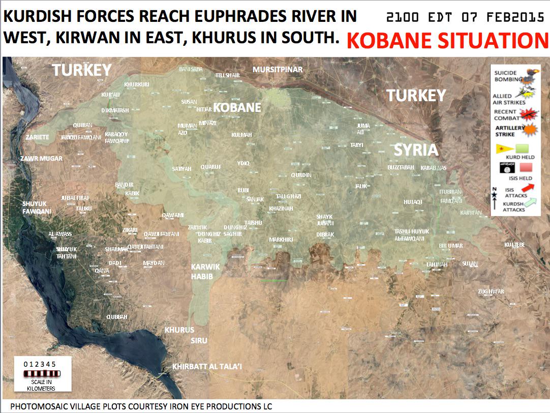
I know, I want to put joint control, the same as you did in south Kobane villages. This Akrad commander is a good source, mainly because he would never say that rebels captured a village if there are sources that YPG did it. DuckZz (talk) 20:42, 8 February 2015 (UTC)
- DuckZz Agreed! Hanibal911 (talk) 21:54, 8 February 2015 (UTC)
Sab`Shakur edit
Hanibal911 I rly dont know how SSA captured a village like Sab`Shakur when all the surrounding villages are ISIS held ? Beacause fisrt you have to capture the surrounding villages like Tall Tunaynir,Ilyas Marshu,Dayij,Fahd as Sayyid!?Lindi29 (talk) 14:14, 9 February 2015 (UTC)
- Lindi29Firstly our map does not reflect all villages who had been captured. Secondly pro opposition source confirm that this village was captured by army.here Hanibal911 (talk) 14:58, 9 February 2015 (UTC)
Zanuba edit
Hanibal911 according de syracuse zanuba is in controll by Isis?here.Lindi29 (talk) 19:06, 9 February 2015 (UTC)
- Lindi29 I'm Sorry this is my mistake! On our map this village was marked as contested so I now revert my editing. Hanibal911 (talk) 19:15, 9 February 2015 (UTC)
- Lindi29 But on the map this area marked as under control by army.@deSyracuse Hanibal911 (talk) 19:21, 9 February 2015 (UTC)
- Hanibal911It says Controlled areas : Isis, and the village Khatmalu between Homs and Hama.Lindi29 (talk) 19:25, 9 February 2015 (UTC)
- Lindi29 But pointer noted that the army advances in this area. Map sometimes show that this village under control of ISIS but also sometimes shows that under control by army. So now we need retain this village unchanged. Hanibal911 (talk) 19:37, 9 February 2015 (UTC)
- Hanibal911 I think it better to mark this villages contested beacause it is black and red shown.What do you think mate ?Lindi29 (talk) 19:46, 9 February 2015 (UTC)
- Lindi29 I'd rather just delete this village! As you think? Hanibal911 (talk) 19:50, 9 February 2015 (UTC)
- Haha Lol that made me laugh,we cant delete them mate let's shown them contested for now,hope you agree.Lindi29 (talk) 19:54, 9 February 2015 (UTC)
- Lindi29
 Done Hanibal911 (talk) 20:07, 9 February 2015 (UTC)
- Lindi29
Mashara edit
The map in [38] by Peto lucem shows Mashara on the fron line. Elijah J. Magnier says : " #SAA and #Hezbollah took control of Madhara,Deir-Maqer, Al-Tiha and deir al-adas" all thes nfos proved correct. No reason to think the info on Mashara is wrong. At the worst it can be contested for lack of info.Paolowalter (talk) 22:13, 10 February 2015 (UTC)
Syrian Civil War Map edit
can we change map with http://rudaw.net and http://ku.hawarnewsagency.com/ news? and there are any rules for change map? — Preceding unsigned comment added by Azad4707 (talk • contribs) 01:24, 11 February 2015 (UTC)
2015 Southern Syria offensive edit
Created a new article 2015 Southern Syria offensive. Update it if you like. EkoGraf (talk) 03:54, 11 February 2015 (UTC)
al-Habbariyah edit
Sorry, I haven't see it. I'll remove it.Paolowalter (talk) 07:43, 11 February 2015 (UTC)
Elijah J. Magnier edit
I already did provide a comment in that discussion several hours ago in support of using him as a neutral source. EkoGraf (talk) 08:17, 11 February 2015 (UTC)
A barnstar for you! edit

|
The Tireless Contributor Barnstar |
| For tireless work on the Iraqi and Syrian detailed war maps. Banak (talk) 10:00, 11 February 2015 (UTC) |
- Banak Thank's! Hanibal911 (talk) 10:04, 11 February 2015 (UTC)
Kobane map edit
What is the source of that map u used for the source, it can be pro-kurdish ? — Preceding unsigned comment added by DuckZz (talk • contribs) 23:02, 11 February 2015 (UTC)
- DuckZz Here is my source.here This guy from whom I took the map he is cartographer and he makes maps for some military conflicts. Hanibal911 (talk) 08:00, 12 February 2015 (UTC)
Al masdar edit
This discussion on Al Masdar has been going on for a long time. This source is very reliable surely no less than SOHR. Being pro-gov or pro-opp is irrelevant, reliability is the only issue. Nobody has found any robust reason to support the statement that Al Masdar is not reliable. Actually almost all editors accept it.Paolowalter (talk) 08:42, 12 February 2015 (UTC)
Al-Masheerfa edit
Hanibal911 I added this town but it is not showing in the syrian war map I dont know mb I did something wrong ? here.Lindi29 (talk) 14:13, 12 February 2015 (UTC)
- Lindi29 I'll try to fix it! Hanibal911 (talk) 15:04, 12 February 2015 (UTC)
- Lindi29 Done Hanibal911 (talk) 15:29, 12 February 2015 (UTC)
- Hanibal911 thanks :).Lindi29 (talk) 15:36, 12 February 2015 (UTC)
- Lindi29
Help edit
Hanibal911 can you fix(show) the name of 5 villages:Al Jafi`ah,Rasm as Suwayd,Al Haba,Safwani that I added beacause they are not shown in the war map.Lindi29 (talk) 17:49, 12 February 2015 (UTC)
- Lindi29 But they are already marked on the map. What do you want what I would do? Hanibal911 (talk) 17:58, 12 February 2015 (UTC)
Kobane villages edit
I have seen that you used this map as source: http://i.imgur.com/1tI2c23.jpg I think that the user https://twitter.com/MarkMonmonier is not reliable because he has built his maps starting from the wikipedia map, moreover he has a brand new twitter account that can not be used as a source for such a big editing. If you read https://en.wikipedia.org/wiki/Talk:Cities_and_towns_during_the_Syrian_Civil_War#kobane you can see that many of the villages marked as YPG controlled are instead ISIS held. 8fra0 (talk) 13:33, 13 February 2015 (UTC)
- 8fra0 Here another map confirmed data from this map So this mean that I correctly edited the map. Hanibal911 (talk) 13:53, 13 February 2015 (UTC)
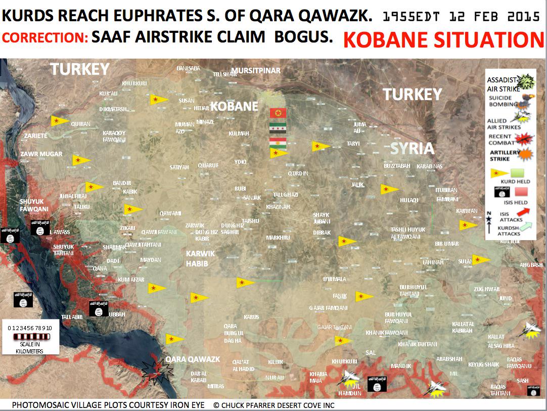
Zabadani edit
Why was this town changed to from lime-red to grey-red contested ? According to SOHR IF and Rebels are clashing against the army ... DuckZz (talk) 21:28, 13 February 2015 (UTC)
- DuckZz I dont know because it's not I did this. But I will correct this inaccuracy. Hanibal911 (talk) 08:36, 14 February 2015 (UTC)
- DuckZz Done Hanibal911 (talk) 08:48, 14 February 2015 (UTC)
- DuckZz
Maragh edit
Hanibal911 I cant find this location with this name but with other name "Marada" which is in Sirte Basinhere,herebut Qasr al Maragh is showing near DernahereI dont know which one is it do you?.Lindi29 (talk) 16:59, 14 February 2015 (UTC)
- Lindi29 In this matter, I hardly can help you because I bad know the map of Libya. But still I try. Hanibal911 (talk) 19:16, 14 February 2015 (UTC)
- Lindi29 Perhaps this.Bi’r Maragh Hanibal911 (talk) 19:43, 14 February 2015 (UTC)
- Hanibal911 I think this is the one I found the same one on Mapcarta and it is an oil well,can you add this one on the libyan war map contested as according to the source.here.Lindi29 (talk) 15:44, 15 February 2015 (UTC)
- Lindi29 Perhaps this.Bi’r Maragh Hanibal911 (talk) 19:43, 14 February 2015 (UTC)
Amiriyat al-Fallujah edit
Hanibal911 this map,hereis not really that reliable and also we cant use this source because is a pro-opp who fights against Isis also if we use this map we have to change a lot of things not just Amiriyat al-Fallujah but other places to.Lindi29 (talk) 15:16, 16 February 2015 (UTC)
- Lindi29 Maybe you are right! Hanibal911 (talk) 19:46, 16 February 2015 (UTC)
- Mate dont get me wrong I didn't rv you just beacause I want that town to be contested but I contested the town beacause I provided pro-regime(irqainews)source but if we go with this map than we have to change a lot of towns and villages if another source comes out for this town then ofc I or we will change it.SincerelyLindi29 (talk) 19:51, 16 February 2015 (UTC)
- Lindi29 Yes, you're absolutely right on this issue. This I made a mistake so that thank you that pointed me to my mistake. Hanibal911 (talk) 20:06, 16 February 2015 (UTC)
- Hanibal911 Dont worry mate everybody makes mistakes it's understandable,I even do more here in Wikipedia beacause I am new here, but the point is to understand from mistakes I always will be here to support and give advise if needed not to make you feel guilty.SincerelyLindi29 (talk) 22:35, 16 February 2015 (UTC)
Operation Canopus Star edit
No need for a new article. We got Operation Canopus Star which was never declared over and its stated aim was the encirclement of Aleppo. This very well may be the end of Canopus Star. Update there please. EkoGraf (talk) 09:56, 17 February 2015 (UTC)
Mu`arrasat al Khan edit
Done [39]. EkoGraf (talk) 19:03, 17 February 2015 (UTC)
Told MrPenguin about that one too to mark it on his map. Also, you were right about Muarrasat, SOHR just confirmed it as well [40], I mean, I'm just guessing that the google translation navigator farms refers to that area. EkoGraf (talk) 19:12, 17 February 2015 (UTC)
PS That last SOHR report also confirms that, despite the numerous rebel claims they recaptured those two villages, the SAA is still holding them. EkoGraf (talk) 19:15, 17 February 2015 (UTC)
Strange village edit
Can you try to locate the village of Khirbat al Atrah. It has been added to the map after failed attack by JAN on Zahraa & Nubl. Does that village even exist ?? DuckZz (talk) 08:40, 18 February 2015 (UTC)
- DuckZz Here this village on mapKhirbat al Atrahhere Hanibal911 (talk) 09:07, 18 February 2015 (UTC)
Seriously lol ? It's an empty area, not mentioned by any source. I'm not saying it's rebel held but should it be really on the map, considering the circle size it looks like a normal sized village but in reality it's maybe 1 destroyed house on a hill. In my opinion, this location should be removed. To show that SAA has some ground west of Zahraa, the green lime icon (west of Zahraa) should be removed too. DuckZz (talk) 09:25, 18 February 2015 (UTC)
Also new petrolucem map shows that area as YPG controled. In the same time, he (Petrolucem) did not put the name Khirbat Atrah on that location what means that nobody controls it as it's not important. DuckZz (talk) 09:34, 18 February 2015 (UTC)
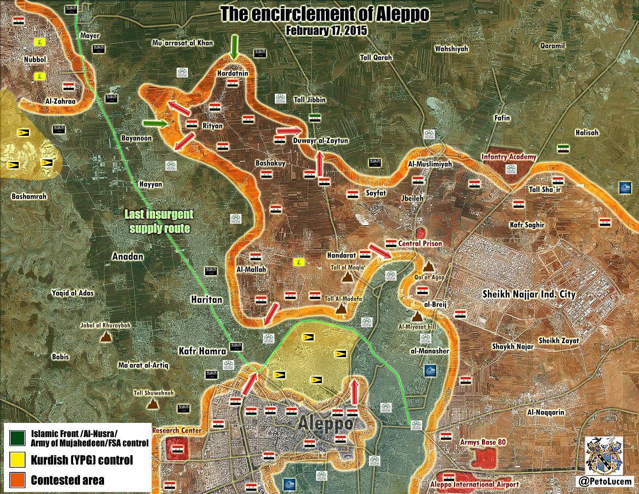
- DuckZzIt the abandoned village.here I think that you are right, we just have to remove it from the map. Hanibal911 (talk) 09:39, 18 February 2015 (UTC)
Um Sharshooh edit
If the FSA is shelling Army positions in the town (per an opposition source) than it is most likely government-held. EkoGraf (talk) 17:41, 19 February 2015 (UTC)
I already inserted the info about Hardatain and Dwer al-Zaytoun at the Canopus Star article and worded it in the most neutral manner as possible. EkoGraf (talk) 19:04, 19 February 2015 (UTC)
Yeah I saw that map. The sticking point here is the opposition is claiming both Hardatain and Dwer al-Zaytoun are mostly recaptured or contested, while the government side is saying both villages are firmly SAA-held. EkoGraf (talk) 20:45, 19 February 2015 (UTC)
Joint control edit edit
The joint control icon for Khan Sheykun looks ok but the Rebel-Kurd icon looks horrible ... it's because the yellow color, it has no shadow or border, and that's why it looks really bad and fade away. I think the way we used to edit the joint control was better, maybe it's a good idea to change it back ? Then we can ask andrea to make some adjusments. DuckZz (talk) 21:15, 22 February 2015 (UTC)
- DuckZz I Agree with you because me also not liked the new icon but maybe we just need to turn to the editor who did this icon and maybe he can improve it. Although the old version was better. If he not fix this new icon then we again mark all those villages as before. Hanibal911 (talk) 21:30, 22 February 2015 (UTC)
111th Regiment edit
Here SOHR says that the regiment should be handed over to Jabhat Shamya (FSA/IF coalition) as a part of the Hazm-Nusra agreement in Darat Iza. This is of course the English version so i don't know if they said it good. DuckZz (talk) 22:49, 27 February 2015 (UTC)
- DuckZz I'll try to find the original report! Hanibal911 (talk) 23:05, 27 February 2015 (UTC)
- DuckZz Here original report!SOHR Hanibal911 (talk) 23:10, 27 February 2015 (UTC)
- DuckZz 111th Regiment under control by Al Nusra.NaharnetThe Daily Star Hanibal911 (talk) 15:17, 28 February 2015 (UTC)
- DuckZz Here original report!SOHR Hanibal911 (talk) 23:10, 27 February 2015 (UTC)
Both sources say that "Al Nusra took over 111th regiment last month". We know that they did that, that's why it was grey but SOHR source was from today in what they said that some agreement was signed between rebels and Al Nusra in Daret Ezzah where it says that Levant front will control the 111th regiment base from now on. DuckZz (talk) 16:04, 28 February 2015 (UTC)
- DuckZz But probably the agreements were broken and now in this area full-scale battles. So that maybe those agreements are no longer current. Hanibal911 (talk) 17:05, 28 February 2015 (UTC)
Don't think so. Al Nusra isued a statement saying that they will not clash against Hazm fighters in Aleppo town but only in the 46th regiment because they want to avoid civilian casulties. Here they also said that they will not fight against Hazm members in Atarib town. So i think it's not a full scale clash, and SOHR's source about the agreement in 111th regiment is probably correct. DuckZz (talk) 18:45, 28 February 2015 (UTC)
Is it just me or there's a bug on the wiki map and some edits are not vissible, for example the villages east or Jarablus are still yellow instead of lime-yellow. But when i wan't to edit them, it shows that i already did it. DuckZz (talk) 22:03, 1 March 2015 (UTC)
- DuckZz Yes for some reason on map not displayed many edits that have been made today! Hanibal911 (talk) 22:14, 1 March 2015 (UTC)
YPG offensive edit
Could you possibly start an article about the YPG Tall Hamis-Tall Brak offensive? I would do it but am at the moment short on time. I will expand it afterwords. I can also ask LightandDark2000. EkoGraf (talk) 19:01, 28 February 2015 (UTC)
- EkoGraf In the coming days I will be busy so I dont know when I can do it. But if someone else can create this article I can help improve the article. Hanibal911 (talk) 19:16, 28 February 2015 (UTC)
- Done Al-Hasakah offensive (February–March 2015). EkoGraf (talk) 01:26, 3 March 2015 (UTC)
Daraa joint control edit
I think it's against the rules to change the map according to 6-8 month old sources. User LogFTW is adding joint JAN-rebel control in Daraa province while providing sources from last year. We already discussed last year on the talk page if we should add the joint control for those specific areas, and most sources showed minimal JAN influence during those offensives, mostly small group that joins rebel groups during their attacks. DuckZz (talk) 15:10, 2 March 2015 (UTC)
- DuckZz I think you're partially right in this situation, since the sources a long time outdated and does not make sense to use these data as they are long outdated. And I remember that we previously talked about the situation in city of Nawa earlier and came to the conclusion that most of the city under the control of moderate insurgents and Al Nusra just has a small number of their fighters in the city so that we cant marked this city as under jointly control rebels and Al Nusra. But here's the situation in the town of Quneitra and the Quneitra border crossing with Israel is extremely difficult because I also earlier saw Israeli sources which reported that in there Al Nusra. So I think you should put the issue about situation in the town of Quneitra on the talk page. Hanibal911 (talk) 15:39, 2 March 2015 (UTC)
JAN is definitely present in Quneitra but how much ? We know that rebels managed to force JAN to release the 40 Captured UN workers in the border crossing, which means they have some influence there. They also raised the "fsa" flag on the border crossing, and we know that JAN is not the biggest fan of this flag. You should revert his edit ...DuckZz (talk) 16:28, 2 March 2015 (UTC)
- DuckZz If I revert those editings here and here I break 1RR. And admins can recognize those my action as a provocation war of editors. So that admins can blocked you and me. You just need to specify all your data on the talk page, and then there we will be able to solve this problem. Hanibal911 (talk) 17:06, 2 March 2015 (UTC)
- DuckZz Here reliable source said that it is al-Nusra took the Quneitra border crossing from Syrian troops.Independent So that probably this crossing correct marked as under jointly control of al Nusra/moderate rebels. Hanibal911 (talk) 10:22, 21 March 2015 (UTC)
From your source. General Rami al-Hassan of the Syrian army claimed: “The first instance of co-operation between the Israeli army and al-Nusra has taken place in Quneitra where al-Nusra took the border crossing, and Israel provided them with cover"
- I think a Syrian army colonel is pro-regime lol, you get my point. DuckZz (talk) 19:12, 21 March 2015 (UTC)
- DuckZz I just gave you data from article from the reliable source and not much else. And this your choice believe or not. I just wanted help look into the matter and nothing more. Hanibal911 (talk) 19:44, 21 March 2015 (UTC)
- DuckZz When I said about reliable source I mean source Independent I not mean that General Rami al-Hassan it is a reliable source. Hanibal911 (talk) 19:59, 21 March 2015 (UTC)
- DuckZz I just gave you data from article from the reliable source and not much else. And this your choice believe or not. I just wanted help look into the matter and nothing more. Hanibal911 (talk) 19:44, 21 March 2015 (UTC)
- I think a Syrian army colonel is pro-regime lol, you get my point. DuckZz (talk) 19:12, 21 March 2015 (UTC)
Talreem? edit
Buddy you added Talreem? I think its already on the map right below where you put Tal Ar Rim. Mozad655 (talk) 18:56, 2 March 2015 (UTC)
- Mozad655 If it so then I remove excess village. Hanibal911 (talk) 19:00, 2 March 2015 (UTC)
- Mozad655 I removed from map the village which I add earlier. Hanibal911 (talk) 19:11, 2 March 2015 (UTC)
Please take care to avoid inserting links to disambiguation pages at Module:Syrian Civil War detailed map edit
Please be more careful to avoid making links to disambiguation pages in complex modules as you did with this edit, adding a link to the disambiguation redirect, Hila. It is particularly important to avoid making this kind of mistake in modules, since these are generally fixed by disambiguators who may not be familiar with the coding used to make modules work, and may have a difficult time implementing the fix. If the article does not exist, create a redlink to the title where the article should exist if created. Cheers! bd2412 T 18:01, 3 March 2015 (UTC)
Raqqa edit
Most likely a mistake. EkoGraf (talk) 18:35, 6 March 2015 (UTC)
SAA advances in Hasakah edit
Please use this map to mark the SAA advances to the northeast of Hasakah city on the map [41]. Thanks! EkoGraf (talk) 18:16, 7 March 2015 (UTC)
source edit
You've made some edits which is fine for all I know but you often use https://twitter.com/EjmAlrai/status/574299801707241472 as source. This guy is not reliable. He is clearly biased and anti-ISIS and he is openly mocking them and critisizing ISIS. He is very pro-Iraq and should not be trusted as he is not reliable but clearly very partial in this conflict. Mozad655 (talk) 12:03, 8 March 2015 (UTC)
- Mozad655 This is rliable source. This guy is a chief international correspondent in the Kuwaiti newspaper of Al Arai. And this source was many times recognized as one of the most reliable sources. Hanibal911 (talk) 12:09, 8 March 2015 (UTC)
Ismail Awa location? edit
I'm pretty sure the current location is wrong. http://www.humanitarianresponse.info/system/files/documents/files/Kirkuk_Gov_Hawiga_District.pdf and http://www.mapaction.org/deployments/mapdetail/index.php?option=com_mapcat&id=3359&view=download&fmt=pdf3359&view=download&fmt=pdf both say its behind Batiwah mountain somewhere around Kharabaroot, but I can't find the exact coordinates. Mozad655 (talk) 18:34, 9 March 2015 (UTC)
- Mozad655 Maybe here Isma‘iliyah or Isma‘il Hanibal911 (talk) 18:42, 9 March 2015 (UTC)
Tal Khanzir edit
Revert 8fra0,tal khanzir is ISIS-held via https://now.mmedia.me/lb/en/NewsReports/564956-syria-kurds-under-fire.Alhanuty (talk) 15:51, 11 March 2015 (UTC)
- Alhanuty It has already made another editor! Hanibal911 (talk) 16:24, 11 March 2015 (UTC)
- Alhanuty You said that you good know Arabic so it may be this report from SOHR there will be useful for you.here Hanibal911 (talk) 16:36, 11 March 2015 (UTC)
Al Karmah Iraqi insurgency detailed map edit
Hi, you haven't made any changes to it.--0ali1 (talk) 22:14, 12 March 2015 (UTC)
- 0ali1 You not right if you look editing history then you see that I marked this town as under control of Iraqi troops.here but another editor revert edit which I made.here Hanibal911 (talk) 08:48, 13 March 2015 (UTC)
Sarrin silos edit
I'm really confuzed with this thing. Why ? Because There seems to be a grain Silos near Sarrin town that is not marked on any map. Why do I say this. First of all, official Rebel & YPG sources said that they have captured a cement factory near Qarah Qawzak.
- Now, the first thing i thought is that they actually don't mean "cement factory" because this location is obviously a factory near Qawzak, but not a cement factory. Then the same sources denied on some twitter questions if they actually mean the Lafarge cement factory more more on the South-East of Kobane, and they said that they don't mean that factory but a factory on the East of Qawzak.
- There is no other factory near Qazwak than this one ? Here are some pictures of rebels there.... Then again, there were reports about coalition airstrikes on ISIS position in a factory near Sarrin these days, so maybe there another factory near Sarrin not marked on any map ? DuckZz (talk) 22:13, 19 March 2015 (UTC)
Qalamun : Quoting the text. "Syrian rebel factions control Zabadani, at the southern end of Qalamoun, and they also have access to Serghaya and Maaraboun". Then next " Hezbollah’s front line here is located at Ham, 2.5 kilometers north of Maaraboun". DuckZz (talk) 10:39, 20 March 2015 (UTC)
- Maraboun is in Lebanon, which means that they don't have acces to Serghaya, only for towns on the Lebanons side. That means Rebels are surrounded in this Perimeter Zabadani axis, all the way to Serghaya for what they have acces to. DuckZz (talk) 10:39, 20 March 2015 (UTC)
- DuckZz Source said that Al Nusra have access to Serghaya and Maaraboun. This confirms that the Al Nusra is located near the town but does not say that they control it and a some pro opposition and neutral sources confirmed earlier that the town is under the control of the army. Here pro opposition map.Archicivilians Hanibal911 (talk) 10:51, 20 March 2015 (UTC)
- Maraboun is in Lebanon, which means that they don't have acces to Serghaya, only for towns on the Lebanons side. That means Rebels are surrounded in this Perimeter Zabadani axis, all the way to Serghaya for what they have acces to. DuckZz (talk) 10:39, 20 March 2015 (UTC)
Aleppo SAA advances edit
What are your pro-opposition sources for Halabi Farms and Nuqat al-Isamat? I want to use them for the Operation Rainbow article. EkoGraf (talk) 09:30, 20 March 2015 (UTC)
Al Zakra edit
Previously SOHR and other pages were reporting about rebels advances there. The problem was, neither the pro-opposition or neutral sources could show where that area was. Here SOHR wrote about this and Eliah Magnier, well he just belives that this was true. The Al Zakat area is right here located, you can see where it says Al Zakat between those mountains, and that's where it starts and it goes all the way with Al Busayri.
- What do you think. Should we change Al Busayri from red to green ? I mean let's see this logicaly, we already have 2 rural green icons, and Al Busayri would connect them, that's probably the reason why rebels are still present there. That's their route as government forces don't use it due to rebel presence there. DuckZz (talk) 01:40, 22 March 2015 (UTC)
- DuckZz Here pro opposition map showed that Al Busayri still under control by Syrian troops.here And we cant on the basis of assumptions edit map. Because the source just said that Islamic battalions have taken over wide areas of Zarka area east of Qalamoun after violent clashes against the ISIS but Al Busayri not was under control of ISIS.. So we cant marked as under control by rebels Al Busayri. And SOHR also clear indicated that this area in Reef Dimashq province but not in Homs province. Hanibal911 (talk) 07:48, 22 March 2015 (UTC)
- DuckZz Also source Elijah J. Magnier not confirmed that Jaysh al-Islam, al Nusra and Usud alsharqiyah capturing al-Zarqa area in rural E.Homs he just publishes data from the pro opposition source https://twitter.com/IbnNabih1 So we cant use this data because they based on rebels amateur video from YouTube and not more. But SOHR said 15 March that rebels captured Zarka area east of Qalamoun.SOHRHanibal911 (talk) 08:24, 22 March 2015 (UTC)
- DuckZz Here Al ZarkaAl Zarka This just a pass between two mountains. All we can specify it on the map as
 Hanibal911 (talk) 08:34, 22 March 2015 (UTC)
- DuckZz Here Al ZarkaAl Zarka This just a pass between two mountains. All we can specify it on the map as
- DuckZz Also source Elijah J. Magnier not confirmed that Jaysh al-Islam, al Nusra and Usud alsharqiyah capturing al-Zarqa area in rural E.Homs he just publishes data from the pro opposition source https://twitter.com/IbnNabih1 So we cant use this data because they based on rebels amateur video from YouTube and not more. But SOHR said 15 March that rebels captured Zarka area east of Qalamoun.SOHRHanibal911 (talk) 08:24, 22 March 2015 (UTC)
- DuckZz Here pro opposition map showed that Al Busayri still under control by Syrian troops.here And we cant on the basis of assumptions edit map. Because the source just said that Islamic battalions have taken over wide areas of Zarka area east of Qalamoun after violent clashes against the ISIS but Al Busayri not was under control of ISIS.. So we cant marked as under control by rebels Al Busayri. And SOHR also clear indicated that this area in Reef Dimashq province but not in Homs province. Hanibal911 (talk) 07:48, 22 March 2015 (UTC)
- What do you think. Should we change Al Busayri from red to green ? I mean let's see this logicaly, we already have 2 rural green icons, and Al Busayri would connect them, that's probably the reason why rebels are still present there. That's their route as government forces don't use it due to rebel presence there. DuckZz (talk) 01:40, 22 March 2015 (UTC)
- DuckZz Done I added az Zarka to map. Hanibal911 (talk) 08:57, 22 March 2015 (UTC)
Libya edit
http://www.aljazeera.net/news/arabic/2015/3/22/-%D9%81%D8%AC%D8%B1-%D9%84%D9%8A%D8%A8%D9%8A%D8%A7-%D8%AA%D8%B3%D9%8A%D8%B7%D8%B1-%D8%B9%D9%84%D9%89-%D8%A7%D9%84%D8%B9%D8%B2%D9%8A%D8%B2%D9%8A%D8%A9-%D9%88%D9%87%D8%AF%D9%88%D8%A1-%D8%AD%D8%B0%D8%B1-%D8%A8%D8%B3%D8%B1%D8%AA this is the source that Toubrok forces pulled out of Azizyah. 3bdulelah (talk) 15:53, 22 March 2015 (UTC)
- 3bdulelah Done Hanibal911 (talk) 16:05, 22 March 2015 (UTC)
Southern Syria offensive strength edit
First, this is a newer source (Wiki policy - new replaces old). Second, Israeli claims in reference to Iran are obviously not reliable. And third, the newest estimate came from a rebel source on the ground which I would say is more familiar with the situation than a news reporter a country away. Fourth, the figure from the newest source is in line with the reports from multiple other sources over the past month, while the 10,000-15,000 claim has only been made by this one source. EkoGraf (talk) 18:56, 26 March 2015 (UTC)
- EkoGraf OK! I agree you convinced me. Hanibal911 (talk) 19:06, 26 March 2015 (UTC)
- EkoGraf You can express your opinion in this discussion.here Hanibal911 (talk) 19:10, 26 March 2015 (UTC)
Kobane edit
I think that the map you used for the last changes in the eastern countryside of Kobane is old (and wrong), if you read this discussion https://twitter.com/_paulo34/status/580859354087297024 you can see the details of Kobane eastern frontline, even Chuck Pfaffer (the editor of the map you used) recognizes that that map is reliable and more updated than his. --8fra0 (talk) 20:32, 26 March 2015 (UTC)
Help edit
Hanibal911 can you rv the editor 8fra0 beacause I rv him once beacasue he edited with the pretext that a consensus was reached on the talk page for the villages in the Tal Tamer but all sources that were provided were 3 pro-side sources there was no reliable source provided or confirmation for this villages here , I provided a reliable source saying that clashes are taking place in the outskirts of the town and there is no clashes taking places in this villages he rv me without a good explantion or a reliable source just saying "you are not specifying where are clashes taking in which part of the outskirt" there were previous sources that confirmed that clashes are taking place in the southwest of the town.Lindi29 (talk) 11:07, 27 March 2015 (UTC)
- Lindi29 Hed marked thosed villages as contested here based on the data which showed situation for 21 and 22 March but here map which dated 24 March and this map showed a different situation. Also just 25 March pro Kurdish source reported that YPG resources reported that the clashes broke out in villages of Til Nesrî, Til Fêda, Til Baz, Til Xerîta, Til Sekra and Til Hirmiz to the south of Til Temir.Hawar News Thus this confirmed that the reports for 21 and 22 March were wrong. So before we revert it editings let's try one last time convince him that he was wrong. Hanibal911 (talk) 11:42, 27 March 2015 (UTC)
- Lindi29 Also here pro opposition source reported that clashing between ISIS and YPG between villages of Ghabish and Tal Shamiran in Tal Tamr countryside. But not in these villages. And the international coalition bombed village of Ghabish.Qasion News Hanibal911 (talk) 15:11, 27 March 2015 (UTC)
- Hanibal911 I already rv him :/,but we will try to convince him anyway,if he dont get then we use the sources.Lindi29 (talk) 16:41, 27 March 2015 (UTC)
- Lindi29 Ok! I agree because we are in this situation was right and provide sources which confirmed our arguments. Hanibal911 (talk) 16:44, 27 March 2015 (UTC)
- Hanibal911 he rv again,he still doesn't get it,he says i told the names of the villages and used a propper source but it's usless beacause he doesn't get it or just dont want to understand that he is using 3 pro-side,Can you please explain to him that he is wrong beacasue i cant rv him anymore beacause I might get blocked for edit war.Lindi29 (talk) 15:29, 28 March 2015 (UTC)
Idlib HELP edit
Someone is deleting my comments on the last talke page, in what i describe the reason why the town should stay in lime color. On the other hand I am deleting comments from a troll and spam user that insults my religion, and talks about Al Qaeda and making the entire map to grey. HelpDuckZz (talk) 17:47, 28 March 2015 (UTC)
I think i have better arguments on the talk page, and you know that either you or me can change the town, nobody else cares about that. DuckZz (talk) 23:14, 28 March 2015 (UTC)
- EkoGrafLindi29ChrissCh94 You can participate in this discussion.here Hanibal911 (talk) 21:41, 29 March 2015 (UTC)
- Lindi29 May you can help me in this situation. This guy ignored all my arguments and all data here which I provided to him from the reliable and opposition sources which confirmed that city of Idlib under jointly control rebels and Al Nusra.here I according to data from a SOHR noted the city of Idlib under jointly control rebels and al Nusra.here But he ignored of all my proofs and again noted it under the full control of only moderate rebels.here I know that you also want what would our map showed the real situation and not personal desires of someone from editors. So maybe you can help me that would remedy this situation. Hanibal911 (talk) 18:51, 31 March 2015 (UTC)
- I'm sorry guys I was quite busy recently but now I'm back! ChrissCh94 (talk) 20:54, 1 April 2015 (UTC)
Yemen Article edit
Hanibal911 mate I think this report (map) will help you to edit the article,you cant find a good map with good explanation than this in details.here.Lindi29 (talk) 13:53, 29 March 2015 (UTC)
- Lindi29 Thank you very much this map will be very helpful to me! Hanibal911 (talk) 15:38, 29 March 2015 (UTC)
Abu al Dardah edit
Hanibal911 mate I have been watching now a long time that you added the abu al dardah hill in Hama with a report from a pro-reble source but I think you have mistaken the place beacause there are 2 place with the name abu dardah which one is near Homs and I think the one you added is really to far from the Usaylah which the regime are shelling from abu dardah.I think you added the hill with this one,here,but I think this is the right one that the source was talking,here which is close to the town which is shelled by the regime here.I apologize if I am wrong.Lindi29 (talk) 17:13, 31 March 2015 (UTC)
- Lindi29 Agreed! I corrected coordinates. Thanks for the hint. Hanibal911 (talk) 18:28, 31 March 2015 (UTC)
- Hanibal911 one question to why is not the town that is rebel held not been added on the map ?.Lindi29 (talk) 16:02, 1 April 2015 (UTC)
- Lindi29 Because we cant add on map a towns or villages and marked their as under control by rebels on basis data from the pro opposition sources. It will be a violation of the rules of editing. Hanibal911 (talk) 17:50, 1 April 2015 (UTC)
- Hanibal911 one question to why is not the town that is rebel held not been added on the map ?.Lindi29 (talk) 16:02, 1 April 2015 (UTC)
Naseeb and Charles Lister and dailystar edit
Naseeb cross was captured,Charles Lister is an analyst for the brookings institute https://twitter.com/Charles_Lister ,a very reliable source,plus dailystar confirmed it http://www.dailystar.com.lb/News/Middle-East/2015/Apr-01/293048-syrian-rebels-seize-jordan-crossing-from-govt-control-rebel-security-source.ashx abu fadel confirmed it https://twitter.com/leithfadel/status/583367581223903232,so revert.Alhanuty (talk) 21:07, 1 April 2015 (UTC)
- Alhanuty Done here Sorry! I not noticed the confirmation from The Daily Mail Hanibal911 (talk) 21:29, 1 April 2015 (UTC)
- [User:Alhanuty|Alhanuty]] Because report from Charli Lister we cant use because he only said that Jabhat al-Nusra (which has played a role with FSA) confirmed that Nassib crossing entirely in opposition control and publishes they statement from the pro-Nusra source.here But it not was a neutral confirmation only statement from Al Nusra. Hanibal911 (talk) 21:36, 1 April 2015 (UTC)
Ayn Suda, Arzaghan Tahtani edit
Hanibal911 please rv yourself beacasue the map and the source that you provided from conflict reporter was talkiing about the M4 highway being attacked by the rebels and the highway is near to Furaykah town and it showed that this 2 town that you put in regime controll are in rebel controll.Lindi29 (talk) 13:58, 2 April 2015 (UTC)
- Lindi29 Done Hanibal911 (talk) 14:16, 2 April 2015 (UTC)
- Also i Fixed an bug from your previuos edit,also the nasib border is fully captured reports SOHR.SOHR and clashes took place in the vicinity of the town of Kafar Shams.Lindi29 (talk) 14:23, 2 April 2015 (UTC)
- Hanibal911 the blue line is the one contested.Lindi29 (talk) 18:27, 2 April 2015 (UTC)
- Blue line indicated that clashes in this area. And blue line near this village but not inside. Hanibal911 (talk) 18:54, 2 April 2015 (UTC)
- Yes Mate that is correct and the report is saying clashes outside the town? that's the report,the report is that that there are clashes in the outskirts of the town not in the town.Lindi29 (talk) 19:39, 2 April 2015 (UTC)
- Hanibal911 the blue line is the one contested.Lindi29 (talk) 18:27, 2 April 2015 (UTC)
- Also i Fixed an bug from your previuos edit,also the nasib border is fully captured reports SOHR.SOHR and clashes took place in the vicinity of the town of Kafar Shams.Lindi29 (talk) 14:23, 2 April 2015 (UTC)
Faylun edit
It this enough to put Faylun under SAA control ? DuckZz (talk) 22:57, 2 April 2015 (UTC)
- DuckZz Yes this data from pro opposition source. This pro oppoition source alo earlier howed that this village under control by army.archicivilians Hanibal911 (talk) 05:35, 3 April 2015 (UTC)
He is more reliable than arcivilians who openly insults the government, bashar etc. DuckZz (talk) 10:17, 3 April 2015 (UTC)
- DuckZz He pro opposition source but no such biased as archicivilians he behaves more correctly without insulting the Syrian troops as this do some more biased pro opposition sources without personal dislike to one of the parties to the conflict. He one of pro opposition sources which try to be more careful and not to publish everything data even if this data are blatant propaganda as do of many other the pro opposition sources which is clear opposed to government. We can call him as of the moderate pro opposition source. Hanibal911 (talk) 17:56, 3 April 2015 (UTC)
Not to open another section. I think this location "Birawi", north of Faylun, should be removed from the map. I can't find it on the wikimap, it probably does exist but it's maybe one a building or something. We already marked bikfalun north of Faylun, enough because that spot is already filled enough with dots. DuckZz (talk) 18:24, 3 April 2015 (UTC)
- DuckZz Maybe because you are right that Birawi too small for village maybe it is a very small hamlet. Here Birawi on map.MapcartaGeonames Hanibal911 (talk) 18:42, 3 April 2015 (UTC)
Another Border Cross edit
Government forces control another border cross with Jordan on the Suweida Border with Jordan,i trying to find that border cross.Alhanuty (talk) 18:14, 3 April 2015 (UTC)
- Alhanuty Maybde this: herehere Maybe they not such big as Nassib or Daraa Border Crossing but they located on roads between two countries. Hanibal911 (talk) 18:35, 3 April 2015 (UTC)
the border cross is inside Suweida province,not in daraa.Alhanuty (talk) 18:40, 3 April 2015 (UTC)
- Alhanuty Maybe somewhere in area of this village.here Hanibal911 (talk) 19:00, 3 April 2015 (UTC)
Just found it.http://wikimapia.org/#lang=en&lat=32.370547&lon=36.919963&z=17&m=b&show=/30384211/Al-Ruwashid-Border-guard-stationAlhanuty (talk) 19:07, 3 April 2015 (UTC)
- Alhanuty But what are you think about this.here Hanibal911 (talk) 19:13, 3 April 2015 (UTC)
the Ruwashid Border Cross is adjacent to the village of Umm Al-Qaser in Suwaydaa,plus the area is desert,and there is a raod that leads to the border cross from the jordanian side.Alhanuty (talk) 19:23, 3 April 2015 (UTC)
Al-Hamamiyat Checkpoint edit
Hanibal911 Again you are missunderstanding Conflict reporter report is talking about the village that is being shelled after the rebels started an offenisve firstly on the checkpoint which was confrimed by reliable source now on the village so removing the semicricle means that the offenisve is not taking place please rv yourselfhere.Lindi29 (talk) 14:08, 4 April 2015 (UTC)
Tahtaya edit
I think this village was contested for a to long time, since we don't have any sources that can back this up. DuckZz (talk) 13:53, 5 April 2015 (UTC)
And something else. I just noticed that someone again changed the areas around Marat Numan to grey, including Hamidiyah and the rest that were lime. We already changed this once, but it looks like someone changed it again, while marking it as a "minor edit" so nobody can notice. DuckZz (talk) 13:56, 5 April 2015 (UTC)
- DuckZz I mark only Hamadiyah as under control by JAN here on based this source.Al Monitor But if you think that I made mistake then I revert this my editing. You know that I very often listen to opinions of other editors and if I'm wrong then I correct my mistake. Hanibal911 (talk) 15:04, 5 April 2015 (UTC)
- DuckZz Also about village of Tahtaya I think that this village maybe under jointly control. But it is just my option but I can try searching some data about situation in this village. Hanibal911 (talk) 15:15, 5 April 2015 (UTC)
I don't know for Tahtaya, it lies deep inside lime rebel territory, but it's definitely not contested. And we did agree with Hamidiyah already as we have seen enough sources from JAN and IF statements alone showing the situation there. You can obviously tell that sources like this are using "AQ" words to attract their readers, and are ignoring everything else. For them, Syria is made up from 90% Al Qaeda and 10% "so called moderate FSA", while other groups don't exist. This source is reliable, but not for this case as every site has its mistakes, just like SOHR. I'm not sure, is Hamidiyah the only place that was changed or am i wrong DuckZz (talk) 15:47, 5 April 2015 (UTC)
- DuckZz Done I agree with your arguments and thus I again mark Hamidiyah as under control by moderate rebels. Hanibal911 (talk) 19:23, 5 April 2015 (UTC)
Twitter Cetin609 edit
Hanibal911 this source that you are using I am watching this source for a long time and it uses olny sources from Kurds,Regime and Assyrian reports.
- Lindi29Map from this source also display data from some many neutral sources which we provide on talk page when Kurds and Syrian troop retake many villages to south from Qamishli andto west from Hasakah. Also this map showed success for all side in this conflict. Also here another map shows almost same situation in Hasakah province. This map displayed the success for all sides (Kurds, ISIS and troops).here Also at the study this source I have not noticed that he used data from the pro-government sources. Maybe we not need use him for displayed success of Kurds becasue I noticed a lot of data from pro Kurdish sources but no more ant this data not report about success of army. Hanibal911 (talk) 16:57, 6 April 2015 (UTC)
- Hanibal911 I dont think that he has really good information he is just reporting from kurds source,I also think that the map from the other source from M.M is based on Cetin609 and some reports from twitter kurds,example on Tal Tamer countryside they use pro-kurd sources to show success for the villages near and contest them and doesn't show Tal Tamer besieged in one side or contested,but reliable sources always talk about clashes in the countryside of Tal Tamer and a new report showed that Tal Tamer contested.So I think to we should not use it to show the success of Kurds beacause he is based on reports from kurds sources.Lindi29 (talk) 21:38, 6 April 2015 (UTC)
- Lindi29Also SOHR reported that clashes near the village of Tal Tamer. And source Mark Monmonier not cooperated with Cetin609. This source made the maps for Syrian war, conflict of Yemeni and sometimes to conflict in Niger. But well, I'll be careful when I use him and also I will search data which can provide my edits if I use this map. Hanibal911 (talk) 06:53, 7 April 2015 (UTC)
- Hanibal911 I dont think that he has really good information he is just reporting from kurds source,I also think that the map from the other source from M.M is based on Cetin609 and some reports from twitter kurds,example on Tal Tamer countryside they use pro-kurd sources to show success for the villages near and contest them and doesn't show Tal Tamer besieged in one side or contested,but reliable sources always talk about clashes in the countryside of Tal Tamer and a new report showed that Tal Tamer contested.So I think to we should not use it to show the success of Kurds beacause he is based on reports from kurds sources.Lindi29 (talk) 21:38, 6 April 2015 (UTC)
Border crossing edit
Lindi298fra0DuckZzEkoGrafXJ-0461 v2PaolowalterAndré437ChrissCh94Daki122Tradedia Maybe we should add to the map all border crossings that exist even unofficial border crossings.herehereherehereherehere How do you think this a good idea? Hanibal911 (talk) 15:36, 7 April 2015 (UTC)
- I agree.Lindi29 (talk) 18:24, 7 April 2015 (UTC)
- Agree XJ-0461 v2 (talk) 21:07, 7 April 2015 (UTC)
You should find some sources where those borders are mentioned. Because we don't know if they are used, mostly because government don't really need them, unlike rebels, for example in this video (on 1:06) it is shown that rebels depend on these "unofficial borders", while on the other hand SAA/Government don't have a reason to use them.DuckZz (talk) 22:10, 7 April 2015 (UTC)
- Agree about adding any border crossing for which we find reasonable sources, even if non-official. It doesn't really matter if they are much used.
- The fairly new official crossing in SW Turkey to Idlib is interesting for one, since it accesses an FSA controlled area in the mountains. The unofficial crossing to Lebanon to Zabadani district was probably (and maybe still is) used by the rebels. There at least used to be a non-official crossing to Jordan before the rebels captured the Daraa crossing. (further west) They help complete the picture of (mostly rebel) supply lines. So they are definitely worth adding.
- It would be interesting if we can find any info about the non-official crossings to Turkey used by Daesh, since official crossings to areas under their control are restricted by Turkey. André437 (talk) 01:23, 8 April 2015 (UTC)
- I agree. There are also unofficial border crossings between Syria and Iraq, used both by ISIS and YPG-Pesh.--8fra0 (talk) 08:41, 8 April 2015 (UTC)
- I don't agree to be honest. Because adding unofficial border crossings means adding illegal smuggling routes and we don't know how many they are. The Lebanese-Syrian Border has at least 20-25 unofficial border crossings and we don't know who controls them nor where they are located. Even though it is quite a good idea, it is not practical in my opinion. ChrissCh94 (talk) 16:55, 9 April 2015 (UTC)
Reliable source ? edit
Hanibal911 do you think this kurd source is reliable?.Lindi29 (talk) 19:55, 9 April 2015 (UTC)
- Lindi29 Why did you decide that this pro Kurdish source? Also if you think that this source cant be used in this issue I revert my edits. Hanibal911 (talk) 20:08, 9 April 2015 (UTC)
- Based on his reports Rojavan Confederation,Efrine Canton this are kurds words when they refer to this places.If I am wrong then give me the the link to this autor who made this map report.Lindi29 (talk) 20:15, 9 April 2015 (UTC)
- Lindi29 Ok! Maybe this source partialy pro Kurdish! And I revert success for the Kurds and for rebels(rebels and YPG cooperated in fight against ISIS in Aleppo provinde) which I showed according to this map. But how you think we can use this map to show success for ISIS. Hanibal911 (talk) 20:30, 9 April 2015 (UTC)
- Mate you didn't finish or edited what was the report map was showing,Qul Suruj example the source says that Isis is advancing in this village and the rojavan sent reinforncement and you didn't edit this part but the question is that I dont know where this news is coming from and the rojavan forces are taking part in defending in that village against Isis no reliable source confirmed that? also Tal Malid is show isis held no reliable source confirmed that also you didn't edit in this to? Saramada being besieged by one side no reliable source confirmed that? and Hawar Nahar is contested in the syrian war map but this map shows it isis held ? Mate I am just asking if it is reliable that's all If it is Pro-kurd we cant use against Isis,If it is Pro-Isis we cant uses on a 3 parties regime,kurds,rebels,If it is Pro-rebel we cant use it against 2 parties regime,isis,If it is pro-regime we cant use it agaisnt 2 parties rebels,isis,If it is pro-Nusra we cant use it against 4 parties rebels,regime,kurds,isis.I am not giving my opinion until I know from what reports is this map based from those that I mention,you said is "maybe" half pro kurd and the other half ? regime,rebels,isis,nusra who knows, I dont know ? You used it mate you have to explain that ?Lindi29 (talk) 20:53, 9 April 2015 (UTC)
- Based on his reports Rojavan Confederation,Efrine Canton this are kurds words when they refer to this places.If I am wrong then give me the the link to this autor who made this map report.Lindi29 (talk) 20:15, 9 April 2015 (UTC)
- Lindi29 For now I revert all success for the YPG and rebels which I showed according to data from this map. But I left all success which I showed for ISIS because this map obviously not from pro-ISIS source. Also I think that it is not biased pro Kurdish source. He just used Kurdish name for the Afrin District here Afrin Canton. So maybe we'll can make an exception for this source as we did this for SOHR. Although we know that the chief of SOHR openly opposes against the Syrian government and he call soldiers of Syrian army as the regime forces. Hanibal911 (talk) 21:13, 9 April 2015 (UTC)
- Mate the fact that he wrote Rojava Confederation is a pro-kurd source ? the word Efrin Afrin is the same but the offcial one is Afrin in Arabic and Efrin name is the Kurd one.Lindi29 (talk) 21:25, 9 April 2015 (UTC)
- Lindi29 So what we do with this source? Hanibal911 (talk) 21:32, 9 April 2015 (UTC)
- Mate the fact that he wrote Rojava Confederation is a pro-kurd source ? the word Efrin Afrin is the same but the offcial one is Afrin in Arabic and Efrin name is the Kurd one.Lindi29 (talk) 21:25, 9 April 2015 (UTC)
- The same thing that we do with other sources that are pro-side source.Lindi29 (talk) 21:42, 9 April 2015 (UTC)
- Lindi29 OK! Hanibal911 (talk) 21:46, 9 April 2015 (UTC)
this map make helped show ISIS advances in Tal Tamir.Alhanuty (talk) 23:41, 9 April 2015 (UTC)
- Alhanuty How you think we can use this source for displayed success of rebels and troops. Hanibal911 (talk) 09:41, 10 April 2015 (UTC)
hard so say,honestly.Alhanuty (talk) 18:05, 10 April 2015 (UTC)
Tal Asfar edit
DeSyracuse has wrongly pointed Tal Asfar as regime-held http://umap.openstreetmap.fr/fr/map/desyracuse-syria-civil-war-8-january-2015_25484#12/33.0871/36.8988,then Syracuse puts it as ISIS-Held http://umap.openstreetmap.fr/fr/map/desyracuse-syria-civil-war-9-feb-2015_28372#11/33.0464/36.9199 ,then pro-government media say that they captured Tal Asfar,that is confusing http://www.almasdarnews.com/article/breaking-syrian-army-secures-tal-asfar-khalkhalah-airport-sweida/ Althoguh Pro-government sources putted Tal Asfar as ISIS-held since november.any thoughts on the issue.Alhanuty (talk) 18:04, 10 April 2015 (UTC) the SOHR reports say one position was regained,but the clashes are continuing.http://syriahr.com/en/2015/04/clashes-renew-in-tal-tamir-and-al-suwaydaa/ where it states"Clashes continue between regime forces backed by allied militiamen against fighters “likely from IS” in Tal Dalfa’ area east of Khalkhala military airport" you get me right now.Alhanuty (talk) 18:19, 10 April 2015 (UTC)
- Firstly source Al Masdar many times made serious errors in their reports and secondly, source just said that army secured of the besieged area including Tal Asfar and Tal Delfa but not said that this objects was under control of ISIS and that troops recaptured their. Also this source reported about Tal Asfar and Tal Delfa but Tall Asfar and Tall Dalfa but this hills but not villages. So that we only can put on map as under control by ISIS just hill of Tall Asfar but not village. Also why you put black semicircle near hill of Tall Dalfa because SOHR clear said that ISIS advanced in this area and that clashes in area of Tal Dalfa but troops regained area which they lost so not need black semicircle because SOHR clear said that ISIS was pulled back. Hanibal911 (talk) 18:20, 10 April 2015 (UTC)
plus there is an issue i want to point out,about the syrian badiyah,this regime source is saying that ISIS inflitrates Suwaydaa from the Jordanian-Iraqi border area,http://www.vetogate.com/1576116,and leith in one of his maps sort of shows it,http://pbs.twimg.com/media/B8n1Y6vCAAAh42A.jpg,"this shows that nobody really controls the area after Zelaf",and jordan has noted that "no longer a regime presence on the border with Jordan"http://www.telegraph.co.uk/news/worldnews/middleeast/syria/11510617/Al-Qaeda-backed-rebels-seize-Syria-Jordan-border-post.html.Alhanuty (talk) 18:23, 10 April 2015 (UTC)
- Alhanuty SOHR just said that clashes continued after ISIS advanced in this area but army regained this area. So SOHR clear said that Syrian troops go in counterattack and for now troops advanced gainsts ISIS so not need black semicircle near hill of Tall Delfa.SOHR If in the coming days, we a have new reports from SOHR about clashes near of this hill then we will put this icon. Hanibal911 (talk) 18:35, 10 April 2015 (UTC)
- Alhanuty Also this source said that Army lost all official border crossing.The Telegraph also here mapfrom BBC and this map not mention that ISIS present in the area.BBC and here pro opposition source which showed that most part of Suwayda province under control by Syrian troops.here Hanibal911 (talk) 18:44, 10 April 2015 (UTC)
- Alhanuty SOHR just said that clashes continued after ISIS advanced in this area but army regained this area. So SOHR clear said that Syrian troops go in counterattack and for now troops advanced gainsts ISIS so not need black semicircle near hill of Tall Delfa.SOHR If in the coming days, we a have new reports from SOHR about clashes near of this hill then we will put this icon. Hanibal911 (talk) 18:35, 10 April 2015 (UTC)
the BBC map is inaccurate,Thomas's map shows that ISIS-held Areas in Suwaydaa is conncted to those of Raqqa,also showing Dirat At-tulul as ISIS-Held,plus a regime sources is talking about ISIS infiltrating the area,there,proving that the badiyah is really an empty area tat no one controls.Alhanuty (talk) 18:54, 10 April 2015 (UTC)
- Alhanuty And this source here only showed wher rebels, Kurds and ISIS positions in Syria but not showed that army not control area between Syria and Jordan. And this source Vetogate distort data from SANA because SANA just said that Units of the army and armed forces thwart an attempt by ISIS terrorists to infiltrate towards Zalfa’a and Abu Harat areas in the northern countryside of the southern Sweida province, killing and injuring scores of them.SANA And SANA not said that Syrian troops not control border area. And we cant use data from biased antigovernment source for displayed success of ISIS becaue this source against the government. Also pro opposition source deSyracuse showed that border area under control by troops. So let us not distort the map. But if you want I removed red icon near Jordan border or move him to down. Hanibal911 (talk) 19:02, 10 April 2015 (UTC)
VetoGate is a pro-regime source,and they admit that ISIS is inflitrating the desert at the Jordanian-Iraqi Border,i advise that the dots in Eastern Rif Dimashq to be removed.Alhanuty (talk) 19:11, 10 April 2015 (UTC)
- Alhanuty You indicated on this icon
 in Rif Dimashq Governorate or in Suwayda province. Hanibal911 (talk) 19:17, 10 April 2015 (UTC)
the Rif Dimashq one,the regime clearly controls Suwaydaa Badiyah,but not the rif dimashq one.Alhanuty (talk) 19:21, 10 April 2015 (UTC)
- Alhanuty Done here Hanibal911 (talk) 19:32, 10 April 2015 (UTC)
what about this article,it states that the oppositions captured Al-Ulanniyah and Halbah from ISIS,http://syrian-mirror.net/en/cat/syria-mirror/al-fath-al-mubin-battles-clash-over-the-supply-routes-with-isis/
- Alhanuty But this only pro opposition source. He called Syrian troops as Regime forces so this not neutral source.here Also he said that armed opposition forces were able to liberate the bulk of Daraa city (Darra al-Balad, al-Sad, Mukhayam, and the surrounding fields), regime forces maintained control over (al-Mahata district) but this not neutral statement this one of opposition sources.here Also he said that Regime forces continue to rain the Yarmouk camp with barrel bombs and artillery shelling.here When source called Syrian troops as the regime forces this not neutral source. This just biased pro opposition source. So need confiration from neutral source. Hanibal911 (talk) 06:56, 11 April 2015 (UTC)
Thaala airbase edit
Template:Syrian Civil War infobox edit
Could you way in on an issue at the infobox? I added Qatar as a supporter (alleged) of Nusra based on at least three sources I added. Editor NullaTuccati first tried to remove them saying it was mere speculation and quotation is needed. When I quoted the sources, noted the alleged tag was there since its speculation as he says and reinserted the info he made a rather controversial edit. He first added Belarus as a supporter of the government, even though his source says the US accused Belarus of trying to arm Syria. Nothing about them actually managing to arm them. Intent is not same as actually doing it. Also, he moved Russia from supporter to beligerent based on two sources (one source citing rebel propaganda video of an alleged Russia spy station; and the second an article from an unverified site that I found to be a copy-paste from a blog about the Russians spying on the rebels). I think his edit should be reverted but I already did one revert today. EkoGraf (talk) 19:59, 11 April 2015 (UTC)
- EkoGraf I also correct some mistakes which he made. Hanibal911 (talk) 20:35, 11 April 2015 (UTC)
- Hanibal911 But he also marked on the basis of rumors that Syria supports ISIS but this is absurd because they are fighting against the Syrian troops. He is the very strange editor which distorts data in the article. He adds data if they even the not been confirmed. Hanibal911 (talk) 20:52, 11 April 2015 (UTC)
- I think he simply did it because I added the info about Qatar. And I think the part about Syria supporting ISIS (while they are engaged in a frontline war) is ridicules and should be removed as soon as possible. I checked all three of his sources. First one [43] are claims made by an opposition dissident (not reliable), second source [44] mostly talks about alleged support to Nusra actually, not ISIS, and most of the sources cited are again rebels and defectors (not reliable), third source [45] also cites the opposition SNC as a source for an alleged unholy alliance between Assad and ISIS. And the alliance seems to be mostly based on a non-aggression pact. Even if they agreed not to attack one another, that does not mean Syria provides support to ISIS. But the heavy fighting between ISIS and the SAA over the last year I think makes this source far from correct. Also, one last thing, all three sources are at least a year old if not longer and even talk about events that happened at the very start of the war, so they are out-of-date. And further evidence of these sources not being valid anymore is the fact that thousands of both SAA soldiers and ISIS fighters have been killed fighting eachother since these reports were made. Even if Syria at one point allegedly supported ISIS, newer sources speak to the contrary. EkoGraf (talk) 04:40, 12 April 2015 (UTC)
- Hanibal911 But he also marked on the basis of rumors that Syria supports ISIS but this is absurd because they are fighting against the Syrian troops. He is the very strange editor which distorts data in the article. He adds data if they even the not been confirmed. Hanibal911 (talk) 20:52, 11 April 2015 (UTC)
Latakia edit
Leith Article of Northern Latakia http://www.almasdarnews.com/article/syrian-army-on-the-move-in-northern-latakia-turkish-border-crossing-within-distance/ are confirming the situation and frontlines in Archicivilians latakia map https://twitter.com/archicivilians/status/550329403071553538,so how should we change the map to reflect the situation confirmed by Al-Masdar.Alhanuty (talk) 15:02, 13 April 2015 (UTC)
- Alhanuty He just said that SAA also targeted the Coastal Brigades and Jabhat Al-Nusra at the villages of Nabi’ Al-Mir, Al-Sooda, ‘Ateerat, and Ghammam in northern Latakia. But not said that this villages under control rebels and Al Nusra. But we not that this source sometimes make mistakes in articles and the word "at" has many meanings sometimes this mean (in,on, for, when, near, about) So if sometimes source said that clashes or that army or rebels targeted position at the village it does not always mean that it is within the village. Also pro opposition source deSyracuse here showed that those villages Ghamam and Nabi’ Al-Mir under control by Syrian troops and this also confirm another source.here So we dont need to change anything on the map. Source clear said that Rabia it is a rebels stronghold and I marked this village as under control by rebels. And we earlier put green semicircle near village of Nabi’ Al-Mir according to data from SOHR so that likely this source indicated that troops also targeted some rebels and al Nusra which located near those villages. But this source cant be used as confirmeation to the map from archicivilians and his map too outdated. Hanibal911 (talk) 15:32, 13 April 2015 (UTC)
Targeting them at these Villages,means they are under rebel control,and Archicivilians had it there,and now it is confirmed,and plus the map of latakia was misleading and now,Al-Masdar admitted the real situation,Al-Masdar is a pro-regime source,and it confirmed the frontline,and alot complained before that the fronline at latakia is misleading and some pro-regime editors here,intentionally did so.Alhanuty (talk) 16:05, 13 April 2015 (UTC)
- Alhanuty Why you marked many villages as undercontrol by rebels but source just said that army targeted the Coastal Brigades and Jabhat Al-Nusra at the villages of Nabi’ Al-Mir, Al-Sooda, ‘Ateerat, and Ghammam but not said that those villages under control of rebels. We edit only on bases data from reliable sources rather than assumptions. Source just said that Rabia under control by rebels but not said that other villages also under theitr control. Also he not said clear that army target the rebels positions inside of those villages. For now I marked their as contested but if we not have other clear confirmation of the presence of insurgents in these villages we need again marked their as under the control of the army and put a green semicircle near them. Because if sometimes source said writes "at" this not mean that "in". Here other maps:herehere Hanibal911 (talk) 16:08, 13 April 2015 (UTC)
because Al-Masdar's frontline completely agrees with Archicivilians map,like what JAN is isolated in Ghamam,JAN is isolated in Ateera and Sooda,situations like these happened in the past and we solved it the same way,rememeber East Hama,Lajat, and other locations,where we had the same issue,if it wasn't for Al-Masdar report,i would have left it the same,but Al-Masdar confirms it.
- Also this source so many times make mistake in their reports and map from and Archicivilians too biased pro opposition source and he is data for January but later deSyrqacuse and some other showed that those villages under control by army. So we cant be used as confirmation for map from the Archicivilians the article from the Al Masdar.
- Alhanuty We only can mark as contested those villages Nabi’ Al-Mir, Al-Sooda, ‘Ateerat, and Ghammam and not more. Everything else it is not justified vandalism. Hanibal911 (talk) 16:19, 13 April 2015 (UTC)
Al-Masdar confirms Archicivilians map,plus Hannibal it doesn't make sense for regime forces to control villages deep in rebel territory,so with Al-Masdar's confirmation,Archicivilians map about Latakia is now confirmed to be true,based on Al-Masdar's report.Alhanuty (talk) 16:24, 13 April 2015 (UTC)
- Your actions based on data from biased pro opposition source. Al Masdar just mentioned four village but you marked all the others on the basis of your desire. More I do not want to talk with you because you are misrepresenting map only based on your personal assumptions. Hanibal911 (talk) 16:31, 13 April 2015 (UTC)
LEITH CONFIRMED IT THAT THEY ARE Coastal brigade and JAN HELD https://twitter.com/leithfadel/status/587655276368625664.Alhanuty (talk) 16:36, 13 April 2015 (UTC) I am trying to make the situation clear,that is it,Leith Abu Fadel confirmed it that they are coastal and JAN-held,so why put it contested,plus,the map was intentionally vandalized in 2014,but we couldn't catch the vandalizer,now Leith confirms these advances.Alhanuty (talk) 16:47, 13 April 2015 (UTC)
- Alhanuty So we just can marked under control by rebels Nabi’ Al-Mir, Al-Sooda, ‘Ateerat and Ghammam and nothing more but we cant use in this issue data from the outdated biased pro opposition source. And I mark these villages as under control by rebels. But we can edit only according to data from the source but we cant used data from outdated pro opposition source. Especially if the other sources later refuted thisdata.herehere Hanibal911 (talk) 17:01, 13 April 2015 (UTC)
but he says it will hard to capture those mountains https://twitter.com/leithfadel/status/587655710508523520.Alhanuty (talk) 17:05, 13 April 2015 (UTC)
- But it not mean that all the villages around under control by rebels. We must made editings on map only based on specific data. Hanibal911 (talk) 17:16, 13 April 2015 (UTC)
Leith Abu Fadel confirmed that Arhcicivilians map about Latakia is accurate here,https://twitter.com/leithfadel/status/587664979807055872 and here https://twitter.com/leithfadel/status/587665101941006336,so all the edits i made were correct,so self-revert.Alhanuty (talk) 17:18, 13 April 2015 (UTC)
- Alhanuty But it not mean that all the villages around under control by rebels. We must made editings on map only based on specific data. If you remember that the two military camps and several villages in the Idlib province long time was of under the control of the army and the rebels could not take them even though they were deep in area which was under control by rebels and Al Nusra. But the fact that were hard to capture their not means that the surrounding villages was as under the control by army. He said that those the data was correct in December but now April and other pro opposition and neutral sources showed another situation.herehere Hanibal911 (talk) 17:28, 13 April 2015 (UTC)
- Alhanuty Also, we cant make such major changes only on the basis of an application for Twitter. Not one from relaible sources including SOHR not reported that all those villages was captured by rebels. Hanibal911 (talk) 17:34, 13 April 2015 (UTC)
- Alhanuty But it not mean that all the villages around under control by rebels. We must made editings on map only based on specific data. If you remember that the two military camps and several villages in the Idlib province long time was of under the control of the army and the rebels could not take them even though they were deep in area which was under control by rebels and Al Nusra. But the fact that were hard to capture their not means that the surrounding villages was as under the control by army. He said that those the data was correct in December but now April and other pro opposition and neutral sources showed another situation.herehere Hanibal911 (talk) 17:28, 13 April 2015 (UTC)
leith confirmed it,that is it,Alhanuty (talk) 17:37, 13 April 2015 (UTC) i don't want to break the 1rr rule,so self-revert,self-revert isn't considered a revert,i had doubts about the situation in latakia,alot of green villages turned red,suddenly,and here leith confirms it,also SOHR periodically mentioned clashes in the area.Alhanuty (talk) 17:40, 13 April 2015 (UTC)
- Alhanuty He only confirmed that the data in this map here were relevant on the end of December, but now middle of April, and these data are outdated. Here new data And not one reliable source not confirmed that now this villages under control by rebels.herehere Hanibal911 (talk) 17:43, 13 April 2015 (UTC)
all these maps were based on our wikipedia map,DeSyracuse admitted that he depends on our map for his edits,and the iranian map does the same.,please hannibal,just self-revert them .Alhanuty (talk) 17:46, 13 April 2015 (UTC) meanwhile,Cedric Labrousse and Archicivilians don't depend on our map for their maps.Alhanuty (talk) 17:48, 13 April 2015 (UTC) plus leith confirmed the map to be accurate and up to date.Alhanuty (talk) 17:49, 13 April 2015 (UTC)
- Alhanuty He also confirmed that this also good map here with some minor mistakes in Latakia.here Hanibal911 (talk) 18:02, 13 April 2015 (UTC)
- Alhanuty He said that on this map here only one mistake.here Hanibal911 (talk) 18:07, 13 April 2015 (UTC)
- Alhanuty He also confirmed that this also good map here with some minor mistakes in Latakia.here Hanibal911 (talk) 18:02, 13 April 2015 (UTC)
he only mentioned one mistake out of several.Alhanuty (talk) 18:08, 13 April 2015 (UTC) this is the problem hannibal is that alot of edits and situation gets buried,then suddenly they get mentioned and we find out the situation has changed without us noticing,back in 2012,before you came here,we had a similiar situation we had Jisr AL-Shoughour as rebel-held based on reliable reports,then suddenly,it came out to be regime-held,same happened with kafr shams,it was regime-held,then we recently find it it was rebel-held,back then in 2013-2014,editors used to make vandalizing edits without notice,and it went on for long,but now it is harder to do that,but,i thank you hannibal for being careful in these situation,and you reverted based on good faith.Alhanuty (talk) 18:16, 13 April 2015 (UTC) someone intentionally made these vandalizing edits in latakia back i 2014,but no one realized it,and now,we find out about it,hopeful for continued cooperation.Alhanuty (talk) 18:17, 13 April 2015 (UTC) Stop,insulting me okay.Alhanuty (talk) 18:45, 13 April 2015 (UTC)
- Alhanuty Ok! Sorry for the insult. Hanibal911 (talk) 18:48, 13 April 2015 (UTC)
Umm al-Kabr edit
Hanibal911 you edited with a pro-side source here.Lindi29 (talk) 13:57, 14 April 2015 (UTC)
- Lindi29 We can use pro opposition sources for displayed success of Syrian troops. This not break the rules. We can use pro opposition sources for displayed success of army in clashes against rebels,JAN and ISIS but cant use their fror displayed success of JAN, rebels and ISIS in clashes against Syrian troops because pro opposition source clear opposes troops. And if source called the Syrian troops as regime forces or pro-Assad troops we cant use this sources for displayed success of all antigovernment forces. But we can use biased pro opposition source ARA News for displayed success of Syrian troops. Hanibal911 (talk) 14:07, 14 April 2015 (UTC)
- Hanibal911 fisrt ARA news is a pro-kurd source and in this case we cant use it,and kurds in Hasakah cooperate with the regime and we cant use that against Isis.Lindi29 (talk) 14:12, 14 April 2015 (UTC)
- Lindi29 ARA News it is biased pro opposition source and this was confirmed many times. He called the Syrian troops as - pro-Assad security forces, pro-regime soldiers, pro-regime forces. hereherehere Syrian air forces - as pro-Assad warplanes.here This clear opposes to Syrian government and many times was confirmed that he is biased pro opposition sources which also partialy support Kurds but clear against Syrian troops. So we can use this source in this issue. Hanibal911 (talk) 14:31, 14 April 2015 (UTC)
- Hanibal911 ofc he refers to regime? who should he call them ? ARA News has more report base on Kurds advances toward Isis also they use the name Kurdish Region herewhich all kurds use that.This is a pro-kurd source.Lindi29 (talk) 14:41, 14 April 2015 (UTC)
- This source never support of Syrian tropps and earlier we agreed that this pro opposition source which we can use for displayed success of troops against ISIS. So dont need accuse me that I am using biased sources. You better be examined with the editors that use clear the biased pro Kurdish sources to show the success of the Kurds. And the fact that the source of ARA News against the Syrian troops was confirmed many times so not need try confirm that he is pro-government or partialy the pro government source. Also I ask you forgive me but for a while I will busy but as soon as I'll be free then we continue this our discussion. Hanibal911 (talk) 14:56, 14 April 2015 (UTC)
- Lindi29 We previously on the basis the many facts came to concluded that this source "is biase pro opposition source". So that dont need ahain start another discussion of this question because all previously already been decided. We have already agreed to if source reported that the Syrian troops it is a regime troops, pro-Assad force or regime troops this is biased pro oposition source byt also if source reported that the moderated rebels it is a terrorists we said that this bias pro government source. Hanibal911 (talk) 16:22, 14 April 2015 (UTC)
- This source never support of Syrian tropps and earlier we agreed that this pro opposition source which we can use for displayed success of troops against ISIS. So dont need accuse me that I am using biased sources. You better be examined with the editors that use clear the biased pro Kurdish sources to show the success of the Kurds. And the fact that the source of ARA News against the Syrian troops was confirmed many times so not need try confirm that he is pro-government or partialy the pro government source. Also I ask you forgive me but for a while I will busy but as soon as I'll be free then we continue this our discussion. Hanibal911 (talk) 14:56, 14 April 2015 (UTC)
- Hanibal911 fisrt ARA news is a pro-kurd source and in this case we cant use it,and kurds in Hasakah cooperate with the regime and we cant use that against Isis.Lindi29 (talk) 14:12, 14 April 2015 (UTC)
Siege of Nubl and Al-Zahraa edit
I wanted to let you know I made the Siege of Nubl and Al-Zahraa article. Cheers! EkoGraf (talk) 04:44, 19 April 2015 (UTC)
- EkoGrafThank's. It is a good article. Hanibal911 (talk) 12:42, 19 April 2015 (UTC)
- Thank you. :) Made one more article Hama and Homs offensive (March–April 2015). EkoGraf (talk) 07:37, 20 April 2015 (UTC)
- This is also very good article. Hanibal911 (talk) 08:10, 20 April 2015 (UTC)
- Thanks again, and thanks for the barnastar! :D EkoGraf (talk) 10:49, 20 April 2015 (UTC)
- Maybe need create new article becasue Syrian troops started new offensive in Dara province and recaptured five villages(Msaika al-Sharqiya, Msaika al-Gharbiya, Rasm al-Khawabi, Ashnan and al-Dallasa) near Bosra al Harir. pro opp sourceDocuments.Sy and pro gov. source SANAal Masdar and attacked on the city of Bosra al Hahir and for now clashes inside this city. pro opp. source Qasion NewsQasion Newshere Hanibal911 (talk) 12:48, 20 April 2015 (UTC)
- Thanks again, and thanks for the barnastar! :D EkoGraf (talk) 10:49, 20 April 2015 (UTC)
- This is also very good article. Hanibal911 (talk) 08:10, 20 April 2015 (UTC)
- Thank you. :) Made one more article Hama and Homs offensive (March–April 2015). EkoGraf (talk) 07:37, 20 April 2015 (UTC)
Busra Al Harir,Al Karak edit
Hanibal911 pro-gov sources deny that they are fightning inside Busra Al Harir here,and who changed al-karak to contested?here fix them.And one thing else mate The Map is not accurate anymore,I will not edit for a period time beacause I am watching sources who are reliable and accurate,I will keep advising and helping you in cases if you need.Sincerely Lindi29 (talk) 12:49, 20 April 2015 (UTC)
- Lindi29 This pro government source just said that Syrian troops have also captured the towns of Ashnan, Al-DlasahRasem and Al-Khawabi near of Busra Al Harir.here but not denied that the Busra al Hahir contested. Here pro opposition sources reported about clashes in the Busra al Harir Qasion NewsQasion Newshere And I marked Al Karak as contested because pro opposition source showed on map that part of this village still control Syrian troops.here As a compromise solution we can marked this village under control by rebels and put red semicircle near of this village. Hanibal911 (talk) 13:03, 20 April 2015 (UTC)
al-Qasr edit
Hanibal911 the twitter source that you used to edit this village is not reliable and also is suspended so you have to correct this mistake.Lindi29 (talk) 21:24, 21 April 2015 (UTC)
- Lindi29 OK buddy! I fixed this. But also I think that you need revert your edit about Sheikh Hillal because no one source not confirmed that this village contested or captured ISIS all source just said that earlier ISIS attackked on it is village but was pulled back. Hanibal911 (talk) 22:09, 21 April 2015 (UTC)
- Hanibal911 Done.But you didn't fix your mistake yet.Lindi29 (talk) 14:55, 23 April 2015 (UTC)
- Lindi29 I fix but someone revert my edit. And also someone reverted your edit. Hanibal911 (talk) 15:55, 23 April 2015 (UTC)
- Hanibal911 I raised an issue for that on the talk page,you can express you opinion on that.Lindi29 (talk) 17:31, 23 April 2015 (UTC)
- Lindi29 Probably I was right when marked Al Qasr as contested becasue anti-government blog here reported that ISIS only 19 April captured this village. But we cant use data from antigovernment source in this issue because long time this source opposes Syrian government (he every time called Syrian troops as regime forces and Syrian government as the Syrian regime or Assad regime and most his information was based on data from the pro opposition sources) and his data biased. So for now we not have confirmations this informations from reliable and neutral sources we must leave this village as contested. Until we receive confirmation from a reliable source, or from the pro government source. Hanibal911 (talk) 18:12, 23 April 2015 (UTC)
- Hanibal911 No mate this village was isis held since even before this report from pro-opp source which in this case we cant use it to.here.Lindi29 (talk) 18:35, 23 April 2015 (UTC)
- Lindi29 Ok we mark this village as under control of ISIS and Sheikh Hillal as under control by Syrian troops and thus we solve all problems in this issue. You are agree? Hanibal911 (talk) 18:47, 23 April 2015 (UTC)
- Hanibal911 I agree.Lindi29 (talk) 21:39, 23 April 2015 (UTC)
- Lindi29 Done Hanibal911 (talk) 15:06, 24 April 2015 (UTC)
- Lindi29
- Hanibal911
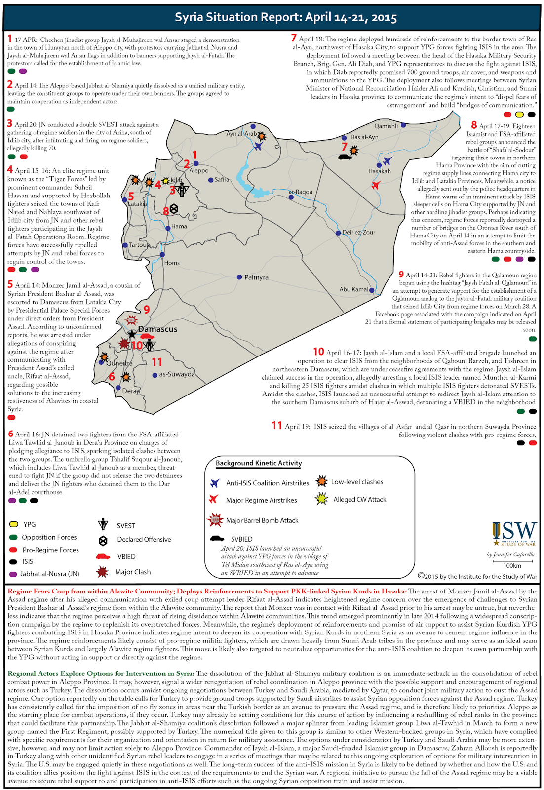
Jisr Shugur edit
SOHR says that rebels seized 5 checkpoints in Qarmed brick factory area and north of Jisr Shugur. The only checkpoint north of Jisr is Zalleto checkpoint. Pro-op sources said that rebels seized "Zaleto" checkpoint. Is this enough ? DuckZz (talk) 07:47, 23 April 2015 (UTC)
- DuckZz Ok I will mark this checkpoint as under control by rebels and add some checkpoints near Qarmed brick factory. And this will be enough. Also pro opposition source said that Jabhat al Nusra shelled Jisr Al Shugour itself today (very rare!), but nowhere attacks it on the ground.here Also here pro opposition source showed that rebels took control over 2 barriers & 1 checkpoint around Jisr Shugur (Zaleto checkpoint) & Potato factory near Qarmed.here and that minimum successes for Rebels during their 24h assault in Idlib and Hama, they failed to enter Jisr Shugur and Qarmed Factory (withdrew)here Hanibal911 (talk) 08:07, 23 April 2015 (UTC)
You don't need to add anything, the map is already cluttered. Just change zaleto checkpoint and that's it, Qarmed factory is still under government control and you don't have to add nothing there. DuckZz (talk) 08:14, 23 April 2015 (UTC)
- DuckZz Agreed! I marked as under control by rebels Zaletto checkpoint and add Mafraq Shugour Checkpoint. Because you are right not need make clutter on map. Hanibal911 (talk) 08:33, 23 April 2015 (UTC)
- DuckZz Also here reliable source explain that rebels captured 5 checkpoints (3 near Qarmed Brick Factory and 2 near Jisr al-Shugur)The Daily Star So I correctly pointed out two security checkpoints near Jisr al-Shugur 3 near Qarmed Brick Factory here this showed pro-Al Nusra source here but I dont want clutter up map just put green semicircle near Qarmed Brick Factory. Hanibal911 (talk) 09:33, 23 April 2015 (UTC)
- DuckZz Also here another biased pro opposition source also confirmed my actions and showed situation near Brick Factory he still under control by Syrian troops Al Nusra and rebels just captured three small checkpoints to east from him.here Hanibal911 (talk) 09:43, 23 April 2015 (UTC)
- DuckZz Also here reliable source explain that rebels captured 5 checkpoints (3 near Qarmed Brick Factory and 2 near Jisr al-Shugur)The Daily Star So I correctly pointed out two security checkpoints near Jisr al-Shugur 3 near Qarmed Brick Factory here this showed pro-Al Nusra source here but I dont want clutter up map just put green semicircle near Qarmed Brick Factory. Hanibal911 (talk) 09:33, 23 April 2015 (UTC)
Editing with pro-side sources edit
Hanibal911This editor is always editing with pro-kurdish sources here destroying the map.I think we should do something ? Lindi29 (talk) 14:22, 27 April 2015 (UTC)
- Lindi29Just sometimes very difficult to explain that we cant use the pro Kurdish sources to show the success of the Kurds. Here are some examples:hereherehereherehereherehere Hanibal911 (talk) 15:37, 27 April 2015 (UTC)
- Lindi29 Here's another editor uses the pro-Kurdish source here in favor of the Kurds.here Just some editors openly ignore the rules. We must be something to do with this. Hanibal911 (talk) 12:56, 29 April 2015 (UTC)
- Hanibal911 can you rv him beacause I rv him once but he rv me.Lindi29 (talk) 21:02, 29 April 2015 (UTC)
- Lindi29 I will decide this issue! Hanibal911 (talk) 08:18, 30 April 2015 (UTC)
- Lindi29 I decided part of this problem with the help of other the pro Kurdish source.here So I think I can fully solve this problem without provoking war edits. Hanibal911 (talk) 09:30, 30 April 2015 (UTC)
- Lindi29 I will decide this issue! Hanibal911 (talk) 08:18, 30 April 2015 (UTC)
Huriyah edit
Thanks! My bad! :) EkoGraf (talk) 20:10, 30 April 2015 (UTC)
Al-Huriyahhere edit
I removed the duplication for Jubb al Ahmar, I did not notice the change you did maybe because of dely in updating. For Al-Huriyah the map twitter.com/Conflict_Report/status/593708410463465472 shows that the village on the top left is under SAA control. It is, I guess, Al-Huriyah. On the other hand the pro-SAA map https://twitter.com/sayed_ridha/status/593756101771796480 shows Al-Huriyah on the front line or contested. What should we do?Paolowalter (talk) 19:58, 1 May 2015 (UTC)
- PaolowalterProbably contested! Hanibal911 (talk) 20:12, 1 May 2015 (UTC)
Az Ziyarah edit
Az Ziyarah is controlled by SAA. That has been widely confirmed. The maps is not very clear on the boundary, but this town is surely red.Paolowalter (talk) 20:34, 1 May 2015 (UTC)
You wrote at the 2015 Jisr al-Shughur offensive article that Ziyarah was captured by the SAA. I wanted to ask what was your source for this? EkoGraf (talk) 13:07, 3 May 2015 (UTC)
- EkoGrafThis confirmed SOHR. Arabic report from SOHR said that troops captured village Ziyarah and large part village of Tall Waset.SOHR And pro opposition source(Conflict Reporter) also confired that the village Ziyarah under control by toopsherehere village Khirbat al-Naqushere and most part the village of Tall Wasethere and area south of Sirmaniyah here and that the village of Sirmaniyah contestedhere Hanibal911 (talk) 13:58, 3 May 2015 (UTC)
- Ok, thanks! When I processed the arabic SOHR report the translation was village visit and large part of Tall Waset. :P Hehehe. EkoGraf (talk) 14:19, 3 May 2015 (UTC)
- EkoGraf But I also have a sometimes there are problems with the translation of reports from Arabic to English. Hanibal911 (talk) 14:31, 3 May 2015 (UTC)
- Ok, thanks! When I processed the arabic SOHR report the translation was village visit and large part of Tall Waset. :P Hehehe. EkoGraf (talk) 14:19, 3 May 2015 (UTC)
Karkiz edit
Hanibal911 Why are you using pro-opp sources against Isis to show regime advance???,also this are reports from pro-regime sources who were cited from pro-opp sources.If a reliable source confrims this then we change so you need to rv your edit.Lindi29 (talk) 14:14, 4 May 2015 (UTC)
- Lindi29This data from the pro opposition(antigovernment source)here which we can use to show success of Syrian troops and pro government source later republished these data.here We can use pro opposition sources for displayed sucess of army but we cant use these sources against Syrian troops. Also for now I try find other confirmations this data, but if today I dont find other confirmations I will remove this village. So that let's wait a little bit. But I assure you that if I not find other evidence I remove from map village Karkiz. Hanibal911 (talk) 15:04, 4 May 2015 (UTC)
- Lindi29 Nevertheless, we have a more serious problem of the use pro Kurdish sources for displaying the success of the Kurds. Something I corrected but it is not a good solution because when we correct such editings other editors again edit the same villages according to data from pro Kurdish sources. But if we revert all such editings then admins can block us for the violation of the 1RR or for provoking the war of edits. Hanibal911 (talk) 15:41, 4 May 2015 (UTC)
- Lindi29 Pro ISIS source said that clashes in village of Karkiz and military housing near Airport. here Hanibal911 (talk) 18:26, 4 May 2015 (UTC)
- Hanibal911 unreliable source,link suspended.Lindi29 (talk) 10:57, 5 May 2015 (UTC)
- Lindi29 Ok! I will remove this village. But for now I edit map for Iraqi conflict but as soon as I finish then immediately delete this village. Hanibal911 (talk) 11:31, 5 May 2015 (UTC)
- Lindi29 Done Hanibal911 (talk) 12:02, 5 May 2015 (UTC)
- Lindi29
- Lindi29 Ok! I will remove this village. But for now I edit map for Iraqi conflict but as soon as I finish then immediately delete this village. Hanibal911 (talk) 11:31, 5 May 2015 (UTC)
- Lindi29 Nevertheless, we have a more serious problem of the use pro Kurdish sources for displaying the success of the Kurds. Something I corrected but it is not a good solution because when we correct such editings other editors again edit the same villages according to data from pro Kurdish sources. But if we revert all such editings then admins can block us for the violation of the 1RR or for provoking the war of edits. Hanibal911 (talk) 15:41, 4 May 2015 (UTC)
Replaceable fair use File:View of the city Ad Dali'.jpg edit

Thanks for uploading File:View of the city Ad Dali'.jpg. I noticed that this file is being used under a claim of fair use. However, I think that the way it is being used fails the first non-free content criterion. This criterion states that files used under claims of fair use may have no free equivalent; in other words, if the file could be adequately covered by a freely-licensed file or by text alone, then it may not be used on Wikipedia. If you believe this file is not replaceable, please:
- Go to the file description page and add the text
{{di-replaceable fair use disputed|<your reason>}}below the original replaceable fair use template, replacing<your reason>with a short explanation of why the file is not replaceable. - On the file discussion page, write a full explanation of why you believe the file is not replaceable.
Alternatively, you can also choose to replace this non-free media item by finding freely licensed media of the same subject, requesting that the copyright holder release this (or similar) media under a free license, or by creating new media yourself (for example, by taking your own photograph of the subject).
If you have uploaded other non-free media, consider checking that you have specified how these media fully satisfy our non-free content criteria. You can find a list of description pages you have edited by clicking on this link. Note that even if you follow steps 1 and 2 above, non-free media which could be replaced by freely licensed alternatives will be deleted 2 days after this notification (7 days if uploaded before 13 July 2006), per the non-free content policy. If you have any questions, please ask them at the Media copyright questions page. Thank you. (ESkog)(Talk) 19:39, 4 May 2015 (UTC)
Libya War Map edit
Stop removing my damn villages. How am I supposed to provide evidence that three villages in the middle of Dawn territory are actually controlled by Dawn? Do you ask the people who colour in the region those villages are in as Dawn green on the map what their source is for making it green instead of black or red? Nspwk (talk) 19:17, 9 May 2015 (UTC)
Oil filed captured in northren Tikrit edit
According to https://twitter.com/rConflictNews/status/597362728181886976 ConflictNews] Isis captured an oil filed and siezed anti-tank missiles.Lindi29 (talk) 17:12, 10 May 2015 (UTC)
- Lindi29 I have seen this data. We not use this source for edit Syrian map(source pro opp.) but maybe we can use him for edit on Iraqi map. Also this data from this source Romain Caillet But the reliability of this source is in doubt. Also these data it is a continuation of this message.Romain Caillet Hanibal911 (talk) 17:28, 10 May 2015 (UTC)
- This is a difrent source it's not Conflict Reporter,also a post from Elijah Magnier spoke about Isis capturing the 26 brigade north of baghdad but no one edited this.Lindi29 (talk) 17:45, 10 May 2015 (UTC)
- Lindi29 I know that it is a difrent source but sometimes this source republishes data from pro opp. sourcesherehere He not such a biased as the source Conflict Reporter but wahn we use him data we need carefully look from the which source he publish data. Hanibal911 (talk) 18:39, 10 May 2015 (UTC)
- Lindi29 So if you think that his data about the Oil field near Tilkrit we can use this data. Hanibal911 (talk) 18:42, 10 May 2015(UTC)
- I think it's reliable to edit with this source and to add the oil field also can you find the 26 brigade and add that to the map.Lindi29 (talk) 20:59, 10 May 2015 (UTC)
- Lindi29 OK! I will do it soon. But I will be grateful if you can help me in this. Hanibal911 (talk) 21:11, 10 May 2015 (UTC)
- Lindi29 I know that it is a difrent source but sometimes this source republishes data from pro opp. sourcesherehere He not such a biased as the source Conflict Reporter but wahn we use him data we need carefully look from the which source he publish data. Hanibal911 (talk) 18:39, 10 May 2015 (UTC)
- This is a difrent source it's not Conflict Reporter,also a post from Elijah Magnier spoke about Isis capturing the 26 brigade north of baghdad but no one edited this.Lindi29 (talk) 17:45, 10 May 2015 (UTC)
- Lindi29 You can help me find military base of the 26th Brigade. Hanibal911 (talk) 17:24, 11 May 2015 (UTC)
Ishtabraq edit
According to this map that you edited this town clashes are not shown near the town but close to a military checkpoint.Lindi29 (talk) 17:55, 10 May 2015 (UTC)
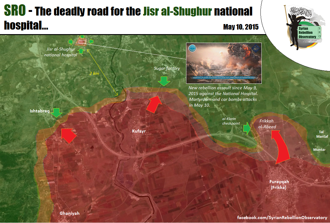
- Lindi29 Map showed that Syrian troops attacked rebels near this village and for now clashes in this area. But if for you these not enough, I can find more data about clashes near this village. Hanibal911 (talk) 18:26, 10 May 2015 (UTC)
- Lindi29 Unlike maps which makes Petro Lucem this source make a more map which showed more detaled place where clashes between army and rebels and according to map from the opp. source clashes on distance 138 m (453 ft) from villge here see map: here So that probably I was right when put red semicircle near Ishtabraq. What you think about this? Hanibal911 (talk) 19:08, 10 May 2015 (UTC)
New article edit
Qalamoun offensive (May 2015). EkoGraf (talk) 02:46, 12 May 2015 (UTC)
Sukhna and Badiyah edit
i got confused about the a large government ammunition warehouse,can you help determine which one was captured via https://uk.news.yahoo.com/islamic-state-makes-gains-syrias-central-province-124415436.html#TZfRwUT.Alhanuty (talk) 15:11, 13 May 2015 (UTC)
- Alhanuty I realy dont know! But why you put black semicircle near T3 because Syria Direct it is biased the antigovernment source which we cant use against Syrian troops. So please remove it. Also probably ISIS captured fuel depot near ammunition warehouse. Also antigovernment source Syria Direct reported that these two weapon storages still control Syrian troops. Hanibal911 (talk) 15:29, 13 May 2015 (UTC)
because the source is against the regime and ISIS,goes with the rule.Alhanuty (talk) 15:35, 13 May 2015 (UTC)
okay,revert my edit on the hajjanah,looks i was wrong on that one.Alhanuty (talk) 15:36, 13 May 2015 (UTC)
- Alhanuty Syrian Direct to biased antigovernment source and earlier we agreed not use all pro opposition sources against Syrian troops and not use all pro government sources against Syrian rebels. So I ask you remove semicircle because source a long time opposes to Syrian troops and his data biased and we cant use him in this situation. Need confirmation from neutral source or pro government source. I hope for your understanding. Hanibal911 (talk) 15:47, 13 May 2015 (UTC)
SyriaDirect is against ISIS.Alhanuty (talk) 15:53, 13 May 2015 (UTC) and they reporting an ISIS advance.Alhanuty (talk) 15:53, 13 May 2015 (UTC) Plus,if Palmrya is attacked,definitely military postions east of it will be threatened.Alhanuty (talk) 15:53, 13 May 2015 (UTC)
- EkoGrafLindi29PaolowalterLightandDark2000ChrissCh94I ask you express your opinion in this situation. Hanibal911 (talk) 16:02, 13 May 2015 (UTC)
i am just expressing an opinion.Alhanuty (talk) 16:15, 13 May 2015 (UTC)
I believe that the most neutral (reliable) source should be used as a precedent. Now, in some cases, the only reliable sources available for the information on certain locations may be slightly biased, and in such cases, I believe that the slighly-slighly-biased sources can be used, so long as they are reputable. This is especially true if the source is directly from the frontline reporting on the side of a certain faction, in which 2 or more opposing sides report conflicting developments at the said location. In such cases, a balanced source should br used instead, or the site should simply be treated as "contested". However, questionable sources, or sources that blatantly only report in favor of one side should be avoided. Now, I haven't exactly looked at the sources in question here, but hopefully, my thoughts may help you decide on this issues. Best of luck, LightandDark2000 (talk) 22:24, 13 May 2015 (UTC)
- Okay, I quickly glanced it over. If Syria Direct meets the criteria for reliable sources, or it is quoting/citing a reliable source, go ahead and use it. If not, this needs to be carefully evaluated, and an alternate source, preferably a neutral or a much more reputable one should be used. LightandDark2000 (talk) 22:29, 13 May 2015 (UTC)
- Hold on, is this source drawing on the account of an ISIS activist? If yes, then we can't use that source at all, because ISIS activists are extremely biased and known for highly exaggerating their victories and covering up their losses. However, if a pro-Syrian Government or a neutral source is reporting this advance, then it can be used. Unless we know how reliable this source(s) is, we need to evaluate it based on what I just outlined in this post. LightandDark2000 (talk) 22:55, 13 May 2015 (UTC)
- Okay, I quickly glanced it over. If Syria Direct meets the criteria for reliable sources, or it is quoting/citing a reliable source, go ahead and use it. If not, this needs to be carefully evaluated, and an alternate source, preferably a neutral or a much more reputable one should be used. LightandDark2000 (talk) 22:29, 13 May 2015 (UTC)
Palmyira edit
You are wrong, because rebels or pro-opposition sources said even last year that they control the Baghdad road along their town of Dumayr, Jarud etc .. until the airport. Those Towns are under truce because SAA needs this road for supply reasons. Petolucem map clearly shows what i changed, and to show you the exact locations look at this area. It's pretty obvious to me. DuckZz (talk) 20:04, 13 May 2015 (UTC)
- DuckZz But as I said early me sorry! I was wrong. Hanibal911 (talk) 20:09, 13 May 2015 (UTC)
- Hanibal911 Ameriya is captured and clashes are in the outskirts of city SOHR.Lindi29 (talk) 15:31, 14 May 2015 (UTC)
- Lindi29 Yes but Syrian troops pushed back ISIS in outskirts of city Palmyra.SOHR So for now not need semicircle. Hanibal911 (talk) 17:15, 14 May 2015 (UTC)
- LOL why not thats why we use the semicircle???.You have to rv yourself.Lindi29 (talk) 19:32, 14 May 2015 (UTC)
- Lindi29 Done Hanibal911 (talk) 19:50, 14 May 2015 (UTC)
- Lindi29
The Area is a desert,not a urbanized area,for concrete resistance,plus ISIS has captured Al-Hayl gas field.Alhanuty (talk) 14:59, 16 May 2015 (UTC)
- Alhanuty OK! I again mark as under control of ISIS 3 villages which locatede near Sukhnah but I dont think that village near Mustadira gas field also was captured because this village located in another area. Hanibal911 (talk) 15:14, 16 May 2015 (UTC)
- Hanibal911 mate here is a map from a pro-gov source who shows the situation in Palmyra and it's still contested,also i think we should really add some more places to show the real situation beacasuse in the war map it shows only Isis on the east side not in the west side.Lindi29 (talk) 14:14, 18 May 2015 (UTC)
- Lindi29 This wrong map! SOHR clear said that Syrian troops pushed back ISIS from the city and that city under control by Syrian troops and that clashes in Amiriyah.The Daily Star Hanibal911 (talk) 14:22, 18 May 2015 (UTC) More relaible pro gov. source also showed that the city under control Syrian troops and clashes in Amiriyah.here SIS for now just shelled city.The Daily Star Hanibal911 (talk) 14:25, 18 May 2015 (UTC)
- Lindi29 In the new report SOHR clear said that the clashes between regime forces and militants loyal to their party, and elements of the "Islamic state" of another party in the outskirts of the city of Palmyra.SOHR Hanibal911 (talk) 14:33, 18 May 2015 (UTC)
- Hanibal911 this report of SOHR is another confirmation,so I am suggesting to add more places and put Palmyria contested and to add the Jabel Qassion mountain in the west of the city where the radio tower and the castle are located.Lindi29 (talk) 14:44, 18 May 2015 (UTC)
- Lindi29 City of Palmyra not contested! Many reliable sources confirmed that the ISIS pushed back from the city of Palmyra. Also repiable source reported that the Syrian troops regained the control of Palmyra archaeological site and hill Syria Tel on the mount Qassioun.Elijah J. Magnier So that all reliable sources clear said that city of Palmra under control by Syrian troops clashes near city. Hanibal911 (talk) 15:01, 18 May 2015 (UTC)
- Lindi29 n addition you can read this article.[Tadmur offensive (2015)] Also yesterday many sources confirmed that the Syrian troops counterattacked against ISIS and pushed back their on distance 1km from the city. So for now city Palmyra under control Syrian troops clashes in some areas outside city including a village Amiriya. Hanibal911 (talk) 15:20, 18 May 2015 (UTC)
- Hanibal911 this map is from yesterday,Ok i dont say that they didn't fall back beacause there were airstrikes on their position in the city,but they fall back only from the city it doesn't mean that they are not near the city so putting the semicircle in the right thing also adding the mountains and the radio tower and the castle to.Lindi29 (talk) 15:31, 18 May 2015 (UTC)
- Lindi29 Area where located radio tower and the castle under control by Syrian troops this confirm reliable sources but probably ISIS control of these mountains(Mount MustadiraMount al-QattarMount 'UbayrahAs Safra) Hanibal911 (talk) 15:48, 18 May 2015 (UTC)
- Hanibal911 Yes,also the palmyra oil field.Add them all as the reliable sources confrim but use the map to show the frontline but only in accordance with reliable sources.Can you add them?Lindi29 (talk) 17:45, 18 May 2015 (UTC)
- Lindi29 Ok I add mountains. But which a reliable source confirmed that Palmyra Gas Field under control ISIS? Hanibal911 (talk) 18:05, 18 May 2015 (UTC)
- Hanibal911 This pro-gov map.Lindi29 (talk) 18:15, 18 May 2015 (UTC)
- Lindi29 As I said earlier this map is incorrect. And another pro government source clear indicated that gas field still under control by Syrian troops.here So if you not have any another reliable sources I think we cant add this gas field. So I only add some mountains. Hanibal911 (talk) 18:23, 18 May 2015 (UTC)
- Lindi29 Done Hanibal911 (talk) 18:44, 18 May 2015 (UTC)
- Hanibal911 I dont think this map that i provided is in incorrect it is just like the map you provided it shows Isis has presence in the mountain area in the west side to also in the north side Mount-Marbat-al-Hasan,and Mount-al-Mazar,Go look SOHR reports on Jazal field where Isis is attacking that field and nobody edited that please check that and that prove that Isis has presence in the westren side to.Lindi29 (talk) 18:58, 18 May 2015 (UTC)
- Lindi29As I said this not correct map and we cant use this map. Because all relaible sources clear said that the city of Palmyra under control the Syrian troops but he is as some pro-ISIS activists reported that city still contested. So his map incorrect. So that I add some hills and for this moment this is enough. We will wait more data from reliable sources. Hanibal911 (talk) 19:39, 18 May 2015 (UTC)
- Hanibal911 I was not talking about the city,So you are saying that these pro-gov sources are wrong about Isis presence in the westren side of Palmyra!?Lindi29 (talk) 19:57, 18 May 2015 (UTC)
- Hanibal911 look even pro-opp are confirming the pro-gov map that i provided,here,[46].Lindi29 (talk) 20:05, 18 May 2015 (UTC)
- Lindi29 I only said about city of Palmyra. And this here not just pro opposition source this is just a biased antigovernment source. So that OK I will add 2 hills but Palmyra under control by Syrian troops and this confirm many reliable sources including SOHR. And pro gov. source showed this map and also noted that city under control by Syrian troops.here Hanibal911 (talk) 20:18, 18 May 2015 (UTC)
- Lindi29 Also pro opposition source (but not some anti government guy from teitter) also clear said that ISIS pushed back from the city of Palmyra and that ISIS “have settled in the al-Maalaf and al-Amariya areas [north of the city] and some of the groves in the southeast vicinity of Palmyra”. Also source clear said that for now Syrian troops are trying to push the Islamic State out of the T-3 pumping station and the al-Hayl gas field 20 km (12 miles) east of Palmyra.EA World Viev So that for now pro government sources, the neutral sources and pro opposition sources clear reported that the city Palmyra under control of Syrian troops. And not need provide me data from this guy(biased dreamer)here Hanibal911 (talk) 20:31, 18 May 2015 (UTC)
- Lindi29 I only said about city of Palmyra. And this here not just pro opposition source this is just a biased antigovernment source. So that OK I will add 2 hills but Palmyra under control by Syrian troops and this confirm many reliable sources including SOHR. And pro gov. source showed this map and also noted that city under control by Syrian troops.here Hanibal911 (talk) 20:18, 18 May 2015 (UTC)
- Lindi29 Also we two days ago noted under control of ISIS the al-Hail and Arak gas fields but reliable sources reported that these gas fields only today was captured ISIS.Al BawabaThe Daily Star and pro opposition source said that Syrian troops try recapture these gas fieldsEA World Viev Also Lebanese TV channel (channel support the Syrian government) reported that the Syrian troops recaptured the town of Al-Ameriya near the city of Palmyra.here And earlier SOHR said that this town was contested. So that let's we take a break and will not rush add objects or edit. Hanibal911 (talk) 20:48, 18 May 2015 (UTC)
- Lindi29 Also another one pro opposition activist Khaled al-Homsi from Palmyra LCC also confirmed that the ISIS never took of the citadel (to west from Palmyra) ISIS was on distance of 1km away from citadel. And that ISIS have settled in the al-Maalaf and al-Amariya areas north of Palmyra.here But as I said earlier SOHR yesterday and today said that that Amiriyah contested but pro government source said that Syrian troops recaptured this town. So for now we have clear confirmation that the city Palmyra under control by Syrian troops. But town of Amiriyah for now contested or under control Syrian troops. Hanibal911 (talk) 21:11, 18 May 2015 (UTC)
- Hanibal911 we will see in the coming days who controlls this areas that we spoke.Lindi29 (talk) 21:18, 18 May 2015 (UTC)
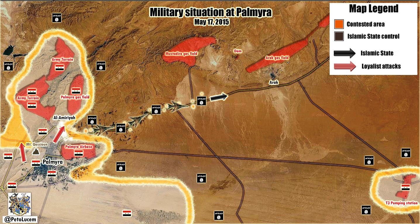
Add Mountains edit
Hanibal911 the eastren countryside of Homs(Palmyra) is really empty and i was thinking that add the mountains in that area is really helpful right now.I wanted to ask you and give your opinion on this case.Lindi29 (talk) 20:04, 14 May 2015 (UTC)
- Lindi29 For now not need! In this area located some hills but for now we dont have reliable data who control their. Let's wait a little bit. Hanibal911 (talk) 20:20, 14 May 2015 (UTC)
Al-Faqi edit
Hanibal911 here is a report from SOHRthat reports for clashes around the the town,also pro-opp source for a time now are reporting for clashes here.Lindi29 (talk) 21:12, 15 May 2015 (UTC)
- Lindi29This not reliable source here He is biased activist which is clear opposes Syrian government and we cant use him data for displayed success of rebels. Also original report from SOHR here clear indicated that the clashes in the vicinity village of Al-Faqi. All what we can do this put semicircle near this village and it is all. And I wanted to tell you that when you write me a message on my talk page you dont need put this notice "u|Hanibal911". Because when you write me on my talk page I get a notification that I have a new message on the talk page. Hanibal911 (talk) 08:02, 16 May 2015 (UTC)
- Lindi29 Done Hanibal911 (talk) 08:35, 16 May 2015 (UTC)
- Lindi29
about the Lajat and the 5 villages,SOHR mentioned that all areas were recpatured by rebel groups,why are they still appearing as regime-held.Alhanuty (talk) 15:02, 16 May 2015 (UTC)
- Alhanuty SOHR only said that rebels recaptured Busra al Harir and some area near city and that troops retreated from this city and it is all. But the reliable source Al Monitor confirmed that the 5 villages not was recaptured by rebels and they stayed under control by army. Look at the history of editing! Hanibal911 (talk) 15:11, 16 May 2015 (UTC)
bring the monitor source.Alhanuty (talk) 15:25, 16 May 2015 (UTC)
- Alhanuty This article from the Al Monitor provide other editor but nevertheless I will try to find for you this article. But for now I'm little busy but as soon I'm released I will do this. I think that the maximum until tomorrow afternoon I will be able to give you this article. Hanibal911 (talk) 16:19, 16 May 2015 (UTC)
- Alhanuty Also after report that the Syrian troops retreated pro opposition source showed that 5 villages was under control of Syrian troops. So it is likely rebels just restore supply line but they not retake villages.deSyracuse Still, I find the source about which I spoke earlier! Hanibal911 (talk) 17:55, 16 May 2015 (UTC)
- Alhanuty Sorry buddy I still not found this article but I still try. Just it is not I found this article at the time when the was made editing. As soon as I find this article, I at once will give it to you link on this article. Hanibal911 (talk) 07:31, 17 May 2015 (UTC)
place edit
do you know where is khirbat Ibrahim Al-muri in the module,because i couldn't find it.Alhanuty (talk) 19:48, 20 May 2015 (UTC) NVM found it.Alhanuty (talk) 19:49, 20 May 2015 (UTC)
- Alhanuty Khirbat Ibrāhīm al Mur‘il in Homs province here and khirbat Ibrahim in Hasakah province here Hanibal911 (talk) 07:23, 21 May 2015 (UTC)
Al-Tanf edit
Credible sources are saying that ISIS seized Al-Tanf border cross https://twitter.com/Nrg8000/status/601439729414897664 and the ANADOLU confirms it,plus ANADOLU is a respected news outlet in turkey,you can't assume it is pro-opposition because it is turkish.Alhanuty (talk) 17:37, 21 May 2015 (UTC)
- Alhanuty Firstly this not reliable sourcehere. And secondly Turkish source only said that ISIS captured crossing between Syria and Iraq so that maybe ISIS captured crossing on Iraqi side. And we cant use Turkish sources against Syrian troops because Turkey clear opposes against Syrian government. Need more accurate data from neutral sources(which not opposes to Syrian troops). Hanibal911 (talk) 17:47, 21 May 2015 (UTC)
- Alhanuty I self revert my editing. But Al Arabia only said that Syrian troops withdraw from the Syrian side of al-Waleed border crossing near Iraq.Al Arabiya And that the Iraqi forces close al-Waleed border crossing with Syria. So that maybe they just retreated from border crossing and for now no one not control this crossing.Al Arabiya Hanibal911 (talk) 18:01, 21 May 2015 (UTC)
Iraqi Amry still controls the Waleed one,all these events are expected from the fall of Palmyra,and things are going to get worse.Alhanuty (talk) 18:09, 21 May 2015 (UTC) http://www.syriahr.com/2015/05/%D8%AA%D9%86%D8%B8%D9%8A%D9%85-%D8%A7%D9%84%D8%AF%D9%88%D9%84%D8%A9-%D8%A7%D9%84%D8%A5%D8%B3%D9%84%D8%A7%D9%85%D9%8A%D8%A9-%D9%8A%D8%B3%D9%8A%D8%B7%D8%B1-%D8%B9%D9%84%D9%89-%D9%85%D8%B9%D8%A8/ What about Jabal Tanf and Al-Tanf on the map,things are going so fast.Alhanuty (talk) 19:54, 21 May 2015 (UTC)
- Alhanuty SOHR said only about border crossing and it is all. We have to edit based on data rather than assumptions. Hanibal911 (talk) 20:42, 21 May 2015 (UTC)
but with Desert areas,things become harder.Alhanuty (talk) 20:56, 21 May 2015 (UTC) What is your view on what is now happening in Homs Province,preety shocking what we are witnessing.Alhanuty (talk) 20:57, 21 May 2015 (UTC)
- Alhanuty Maybe Syrian troops retreated that would regroup as in last year wnen ISIS reetreated from Deir ez Zor after rebels advances but later ISIS advance and take more 90% of Deir ez Zor and large part of Hasakah province. Or also as YPG in the battle for Kobani when in the beginning they retreated but then regrouped and launched an offensive and retake almost all territory which earlier seized ISIS. We also need to consider the fact that ISIS will be difficult move in the desert region because in desert area very little shelters from the Air Force. Now in Syria, the situation is almost the same as in Iraq. But the situation could change at any moment. So let's we will not jump to conclusions. Hanibal911 (talk) 21:13, 21 May 2015 (UTC)
- Alhanuty As I said yesterday ISIS also captured border crossing from Iraqi side so that probably they first captured Iraqi side of border and after they do this Syrian soldiers from border guards retreated because their number was small, and after ISIS captured the Al-Walid border crossing from the Iraq side it was pointless to try to keep the border crossing on the Syrian side.The Daily Star They probably captured this borser crossing for free movement between the two countries. Hanibal911 (talk) 08:35, 22 May 2015 (UTC)
- Alhanuty Also dont need rush edit the map on the basis of assumptions. Because when I said that T3 Pumping Station was still under control by Syrian troops you denied this data but SOHR said that ISIS only today captured this station after the Syrian troops and their allies withdraw from the station.SOHR Hanibal911 (talk) 08:43, 22 May 2015 (UTC)
- Alhanuty As I said yesterday ISIS also captured border crossing from Iraqi side so that probably they first captured Iraqi side of border and after they do this Syrian soldiers from border guards retreated because their number was small, and after ISIS captured the Al-Walid border crossing from the Iraq side it was pointless to try to keep the border crossing on the Syrian side.The Daily Star They probably captured this borser crossing for free movement between the two countries. Hanibal911 (talk) 08:35, 22 May 2015 (UTC)
- Alhanuty Maybe Syrian troops retreated that would regroup as in last year wnen ISIS reetreated from Deir ez Zor after rebels advances but later ISIS advance and take more 90% of Deir ez Zor and large part of Hasakah province. Or also as YPG in the battle for Kobani when in the beginning they retreated but then regrouped and launched an offensive and retake almost all territory which earlier seized ISIS. We also need to consider the fact that ISIS will be difficult move in the desert region because in desert area very little shelters from the Air Force. Now in Syria, the situation is almost the same as in Iraq. But the situation could change at any moment. So let's we will not jump to conclusions. Hanibal911 (talk) 21:13, 21 May 2015 (UTC)
that is the problem of desert areas,because SAA forces can't possibly stay in the villages near Palmyra,they will get cut off,and alot of sources say they retreated to Jazal and Shaer gas fields,and plus after the takeover of Tanf,i really doubt they can stay in desert villages,this is the nature of Desert warfare Hannibal.Alhanuty (talk) 13:17, 22 May 2015 (UTC) and for your information,the last regime map show areas west of Palmyra under ISIS control,so i would advise you to self-revert,and plus SOHR confirmed that ISIS controls the entire Tadmur area.Alhanuty (talk) 13:18, 22 May 2015 (UTC) Tadmur area via http://www.syriahr.com/2015/05/%D8%AA%D9%86%D8%B8%D9%8A%D9%85-%D8%A7%D9%84%D8%AF%D9%88%D9%84%D8%A9-%D8%A7%D9%84%D8%A5%D8%B3%D9%84%D8%A7%D9%85%D9%8A%D8%A9-%D9%8A%D8%B7%D8%A8%D9%82-%D8%B4%D8%B9%D8%A7%D8%B1%D9%87-%D8%A8%D8%A7/ and here is the SOHR source.Alhanuty (talk) 13:19, 22 May 2015 (UTC) actually Elijah Magnier was the one who mentioned that ISIS captured the T3,not an oppositions source,then that questions Elijah credibility then.Alhanuty (talk) 13:20, 22 May 2015 (UTC)
- AlhanutyMaybe later troops retake station. Done And OK I self-revert. Hanibal911 (talk) 13:23, 22 May 2015 (UTC)
ISIS has captured Jazal Oilfield via SOHR http://www.syriahr.com/2015/05/%D9%86%D8%AD%D9%88-200-%D9%82%D8%AA%D9%8A%D9%84-%D9%88%D8%AC%D8%B1%D9%8A%D8%AD-%D9%85%D9%86-%D9%82%D9%88%D8%A7%D8%AA-%D8%A7%D9%84%D9%86%D8%B8%D8%A7%D9%85-%D9%88%D8%A7%D9%84%D9%85%D8%B3%D9%84%D8%AD/ and also ISIS has captured Sawanah via SOHR http://www.syriahr.com/2015/05/%D9%86%D8%AD%D9%88-200-%D9%82%D8%AA%D9%8A%D9%84-%D9%88%D8%AC%D8%B1%D9%8A%D8%AD-%D9%85%D9%86-%D9%82%D9%88%D8%A7%D8%AA-%D8%A7%D9%84%D9%86%D8%B8%D8%A7%D9%85-%D9%88%D8%A7%D9%84%D9%85%D8%B3%D9%84%D8%AD/ and here is Sawanah via wikimapia http://wikimapia.org/#lang=en&lat=34.155000&lon=38.052521&z=11&m=b&show=/7123355/ar/مفرق-الصوانة.Alhanuty (talk) 13:35, 22 May 2015 (UTC)
- Hanibal911 can you remove the syrian army presence near the At-Tanf border beacause the border and the mountains of that area were captured.here.Lindi29 (talk) 16:45, 23 May 2015 (UTC)
- Lindi29 Done Hanibal911 (talk) 16:50, 23 May 2015 (UTC)
- Lindi29
- Hanibal911 can you remove the syrian army presence near the At-Tanf border beacause the border and the mountains of that area were captured.here.Lindi29 (talk) 16:45, 23 May 2015 (UTC)
Jisr Al-Shughur hospital. edit
User Nulla Taciti continues to use pro-opp sources and invalid sources like youtube and reddit in order to say that 100+ SAA were killed in the hospital escape here: https://en.wikipedia.org/wiki/2015_Jisr_al-Shughur_offensive . I keep telling him that we cannot do that, yet he continues to ignore me. I fear the situation may become an edit war. Could you please intervene. Thank you. XJ-0461 v2 (talk) 17:16, 24 May 2015 (UTC)
Al-Melabiya edit
Hanibal911 this village was edited earlier to contested with a pro-kurd source to.Lindi29 (talk) 12:14, 25 May 2015 (UTC)
- Lindi29 Done Hanibal911 (talk) 12:39, 25 May 2015 (UTC)
Sab Cifar edit
Hanibal911 Can you edit this village,beacause I cant find it has different name.here.Lindi29 (talk) 13:43, 25 May 2015 (UTC)
- Lindi29 Done Hanibal911 (talk) 14:40, 25 May 2015 (UTC)
Ghamam edit
Hanibal911 can you rv this editorwho changed this town with a pro-gov source,I explain it to him about the rules of editing with a reliable source,but still he didn't understand it.Lindi29 (talk) 16:44, 27 May 2015 (UTC)
- Lindi29 Done Hanibal911 (talk) 18:13, 27 May 2015 (UTC)
Muthanna Chemical Weapons Facility edit
Please change Muthanna Chemical Weapons Facility from IS to government. This ejmAlRai tweet: https://twitter.com/EjmAlrai/status/604623857731936256 says ISF is "advancing in ISIS land in al-Muthanna". He did not say IS took Muthanna Chemical Facility. Pbfreespace3 (talk) 04:11, 31 May 2015 (UTC)
- Pbfreespace3 Done Hanibal911 (talk) 06:32, 31 May 2015 (UTC)
- A pro-IS editor reverted your change! With no source! -pbfreespace3 — Preceding unsigned comment added by 2601:C7:8380:3B01:88B7:8B74:5652:BEB1 (talk) 14:02, 31 May 2015 (UTC)
- Muthanna Chemical Weapons Facility marked as under control by Iraqi troops. What is the problem? Hanibal911 (talk) 14:28, 31 May 2015 (UTC)
- An ISIS siege icon still exists. It should be removed: the siege was broken by government forces. Pbfreespace3 (talk) 21:06, 31 May 2015 (UTC)
- Muthanna Chemical Weapons Facility marked as under control by Iraqi troops. What is the problem? Hanibal911 (talk) 14:28, 31 May 2015 (UTC)
- A pro-IS editor reverted your change! With no source! -pbfreespace3 — Preceding unsigned comment added by 2601:C7:8380:3B01:88B7:8B74:5652:BEB1 (talk) 14:02, 31 May 2015 (UTC)
Editing with biased sources edit
Hanibal911 is it okay to use biased sources to edit in this syrian war module,beacause i see many editors edit with biased sources.KingoXo (talk) 08:56, 3 June 2015 (UTC)
- KingoXo We cant use according to a rules of editing biased sources but some editors violate these rules. So that we can revert such editing but not more than once in 24hrs. So if you revert one of such editings which is was made on based biased source the next time you can do it no earlier than 24 hours. Or you break a rule of 1RR and you may be blocked. Read this and then you will understand what I mean:here Hanibal911 (talk) 09:11, 3 June 2015 (UTC)
- Hanibal911 OK! Mate.KingoXo (talk) 09:28, 3 June 2015 (UTC)
Hi, I am new to Wikipedia and was wondering if there is a way when looking at the map of the Syria/Iraq/Insurgency War, to see what the changes are day by day? It looks like you are influential in editing it. Is there a way that I can see what changes recently occurred to understand the momentum of the battles? Thank you for any info you can provide. The project is simply amazing that you all are working on! — Preceding unsigned comment added by 216.45.136.205 (talk) 13:36, 3 June 2015 (UTC)
- 216.45.136.205 You can view the history of editing:here and here or you can view a some articles about clashes in Iraqhere and Syriahere Hanibal911 (talk) 13:59, 3 June 2015 (UTC)
Source map edit
Hanibal911 this sourceis not reliable beacause the villages in Tal Brak area are shown black Isis held but they were edited with the same source to show this villages yellow Kurd held.KingoXo (talk) 14:39, 6 June 2015 (UTC)
- You used incorrect map from Kurdish source and I also use map from Kurdish source. So I not violated rules. And also I see that this is you Lindi29 but why you created new acaunt after your acaunt was blocked this a violation of the rules of Wikipedia. You can't to edit map. Hanibal911 (talk) 14:51, 6 June 2015 (UTC)
- Hanibal911 I just provided a pro-kurdish source and you provided another pro-kurdish source to,but I saw that the source you provided it's not like the syrian module in the Tal Brak Area it shows a different situation.KingoXo (talk) 15:26, 6 June 2015 (UTC)
- But other the pro opposition and pro ISIS sources also showed such situation in the area of the town Tal Brak.hereherehere So my source clear indicated that all hills and villages west of Hasakah still under control by Syrian troops.So dont need use incorrect maps. Hanibal911 (talk) 15:36, 6 June 2015 (UTC)
- Hanibal911 I just provided a pro-kurdish source and you provided another pro-kurdish source to,but I saw that the source you provided it's not like the syrian module in the Tal Brak Area it shows a different situation.KingoXo (talk) 15:26, 6 June 2015 (UTC)
Al-Hasakah city offensive edit
New article Al-Hasakah city offensive (May–June 2015). EkoGraf (talk) 19:52, 7 June 2015 (UTC)
Blocked edit
Hanibal911, you have been blocked indefinitely for block evasion as a sock of Deonis 2012. If you are not a sock, you are welcome to appeal this block by using the {{unblock}} template.
To the reviewing administrator, please note that this block is based on private evidence that I cannot share with anyone who is not bound by the Foundation's privacy policy. Salvio Let's talk about it! 10:07, 11 June 2015 (UTC)
Hanibal911 (block log • active blocks • global blocks • contribs • deleted contribs • filter log • creation log • change block settings • unblock • checkuser (log))
Request reason:
I dont understand why I was accused that I is a sock of Deonis 2012 This probably some mistake I even dont know who this guy. I edit in Wikipedia more year and for this period I not created other accounts besides of this. I remember that when as I just create my account and started make edits in Wikipedia some guy but I not remember his name accused me that I sock of editor which was earlier blocked. But I dont know why because I started edit in Wikipedia 30 November 2013 and until that time I had never created other accounts and non make edits in Wikipedia. So I ask you unblock my account because I not a violated rules of Wikipedia I only several times violated 1RR. I dont have any relation to the editor Deonis 2012 as Hanibal911 this is my only account. So that this mistake and I was blocked for no apparent reason. Hanibal911 (talk) 11:03, 11 June 2015 (UTC)
Decline reason:
Please lodge your appeal using the Unblock Ticket Request System so that the private evidence may be adequately addressed. MER-C 13:44, 12 June 2015 (UTC)
If you want to make any further unblock requests, please read the guide to appealing blocks first, then use the {{unblock}} template again. If you make too many unconvincing or disruptive unblock requests, you may be prevented from editing this page until your block has expired. Do not remove this unblock review while you are blocked.
- Salvio giuliano I ask you more carefully researching this situation because I was blocked by mistake. I'm never create other accounts only Hannibal 911 and I have no relation for other editors which were blocked. I just can't understand why I was punished for what I'm not did. It's not fair. Hanibal911 (talk) 11:18, 11 June 2015 (UTC)
- AlhanutyThank's buddy for your support! I really dont know who this guy Deonis 2012. Just be a shame if I will suffer for someone else wrongful actions to which I have no relationship. Hanibal911 (talk) 06:28, 12 June 2015 (UTC)
after being told the evidence was clear,i agree with the admin action.Alhanuty (talk) 12:26, 12 June 2015 (UTC)
- Hanibal911, since no functionary has seen your unblock request and I can't reveal all the evidence I based my block on to non-functionaries, I suggest you use WP:UTRS or send an e-mail to WP:BASC. Salvio Let's talk about it! 17:03, 12 June 2015 (UTC)
Jazal edit
EkoGraf I marked Jazal Oil Field as under control by Syrian troops here but some pro-ISIS editor marked him as contested here on based the antigovernment video herehere You can fix this. Hanibal911 (talk) 11:39, 11 June 2015 (UTC)
- EkoGraf SOHR also reported that Syrian troops retake position in Jazal area.SOHR And some neutral and pro government sources reported that Syrian troops retake village Jazal and its oil field. See on talk page. Hanibal911 (talk) 12:59, 11 June 2015 (UTC)
- EkoGraf Jazal oil field under control Syrian troops.SOHRCeberAmanAl BinaAl AzmenahAl Akhbar but pro ISIS guy marked this Oil Field under control of ISIS according to antigovernment source.here I cant fix this so I ask you do this. Hanibal911 (talk) 17:02, 12 June 2015 (UTC)
- EkoGraf You can fix this? PaolowalterAriskarI also ask you marked Jazal Oil Field as under control by Syrian troops according to data from sources that I gave.SOHRCeberAmanAl BinaAl AzmenahAl Akhbarhere Hanibal911 (talk) 09:12, 13 June 2015 (UTC)
- EkoGrafPaolowalterAriskar Syrian troops also recaptured village Jazal.Shafaqna Hanibal911 (talk) 09:19, 13 June 2015 (UTC)
- EkoGraf You can fix this? PaolowalterAriskarI also ask you marked Jazal Oil Field as under control by Syrian troops according to data from sources that I gave.SOHRCeberAmanAl BinaAl AzmenahAl Akhbarhere Hanibal911 (talk) 09:12, 13 June 2015 (UTC)
Goodby friends! edit
EkoGraf XJ-0461 v2 Paolowalter DuckZz Alhanuty 8fra0 I was glad to edit with you and thank you for your assistance and cooperation. I even want thank those who were often disagrees with me since any discussion brings some benefit. I was accused in something what I did not commit and was punished for others' crimes. Because the main thing for me is that I'm know myself that not guilty. And I have no desire trying to convince someone else in this. Since I consider it is insulting trying to make excuses for what I dont commit. Thank you all for your help and goodbye guys. Good luck!!! Hanibal911 (talk) 16:55, 12 June 2015 (UTC)
This has to be a joke. You need to prove them that they're wrong, because they obviously are. You have the right to complain as much as you can, and when they realize their mistake, they will never bother you again. DuckZz (talk) 17:07, 12 June 2015 (UTC)
You need to appeal! EkoGraf (talk) 17:12, 12 June 2015 (UTC)
- Hanibal911 I don't know what the private evidence is, so I can't tell if you are Deonis or not. If you are, I suggest you request to be unblocked based on the reason that Deonis was banned for sock puppetry and copyright violations, and his appeals were declined on the grounds that he could not understand English very well and thus couldn't contribute without breaking guidelines. Although your Hanibal account would have violated guidelines even further, your conduct for the past year using this account has shown that you are both willing and able to contribute positively to the Wiki, and to respond to admin rulings. The administration may agree to unblock you on such grounds, that although you evaded a previous block that would not be appealed, you did demonstrate that you deserve to be unblocked. This means that had you been unblocked, you would have been a rule abiding member with positive contributions, and this means there is no reason for the block in the first place as you would not be causing harm.
- If the evidence claims are wrong and you are not Deonis, I am sorry for all this, I guess all you can do is do as the others said and appeal this using the ticket system so that the private evidence can be refuted. I just want to let you know that your case isn't hopeless on either count, and giving up will kind of hint that you're guilty to a neutral observer. So whether you're innocent or guilty, don't give up as you still have a chance to remain a valuable member. NightShadeAEB (talk) 17:51, 12 June 2015 (UTC)
- I agree with everything NightShadeAEB said. It has been a pleasure making edits, discussions and other contributions in the Syria project. It is a shame you got blocked, and unless this changes you will be missed. I believe that you have been among the highest contributors on the Syrian civil war map and one of the most objective. I decided in light of this ridiculous fact, that I will stop making edits in the meantime too. All the best.Ariskar (talk) 02:00, 13 June 2015 (UTC)
- EkoGraf NightShadeAEB DuckZz Ariskar am very glad to know that you support me so I will fight that would be all the same to achieve unblocking. But for now I little busy but next week I will try again to appeal a decision about my blocking. I very much hope that I will succeed do this and I return to editing. Wish me luck. Hanibal911 (talk) 07:13, 13 June 2015 (UTC)
- I agree with everything NightShadeAEB said. It has been a pleasure making edits, discussions and other contributions in the Syria project. It is a shame you got blocked, and unless this changes you will be missed. I believe that you have been among the highest contributors on the Syrian civil war map and one of the most objective. I decided in light of this ridiculous fact, that I will stop making edits in the meantime too. All the best.Ariskar (talk) 02:00, 13 June 2015 (UTC)
request an SPI then.Alhanuty (talk) 21:41, 13 June 2015 (UTC)
Replaceable fair use File:View of the city Sarrin.jpg edit
Thanks for uploading File:View of the city Sarrin.jpg. I noticed that this file is being used under a claim of fair use. However, I think that the way it is being used fails the first non-free content criterion. This criterion states that files used under claims of fair use may have no free equivalent; in other words, if the file could be adequately covered by a freely-licensed file or by text alone, then it may not be used on Wikipedia. If you believe this file is not replaceable, please:
- Go to the file description page and add the text
{{di-replaceable fair use disputed|<your reason>}}below the original replaceable fair use template, replacing<your reason>with a short explanation of why the file is not replaceable. - On the file discussion page, write a full explanation of why you believe the file is not replaceable.
Alternatively, you can also choose to replace this non-free media item by finding freely licensed media of the same subject, requesting that the copyright holder release this (or similar) media under a free license, or by creating new media yourself (for example, by taking your own photograph of the subject).
If you have uploaded other non-free media, consider checking that you have specified how these media fully satisfy our non-free content criteria. You can find a list of description pages you have edited by clicking on this link. Note that even if you follow steps 1 and 2 above, non-free media which could be replaced by freely licensed alternatives will be deleted 2 days after this notification (7 days if uploaded before 13 July 2006), per the non-free content policy. If you have any questions, please ask them at the Media copyright questions page. Thank you. Kelly hi! 08:36, 30 November 2015 (UTC)
Contests edit
User:Dr. Blofeld has created Wikipedia:WikiProject Africa/Contests. The idea is to run a series of contests/editathons focusing on each region of Africa. He has spoken to Wikimedia about it and $1000-1500 is possible for prize money. As someone who has previously expressed interest in African topics, would you be interested in contributing to one or assisting draw up core article/missing article lists? He says he's thinking of North Africa for an inaugural one in October. If interested please sign up in the participants section of the Contest page, thanks.♦ --Ser Amantio di NicolaoChe dicono a Signa?Lo dicono a Signa. 01:23, 21 July 2016 (UTC)
AfroCine: Join us for the Months of African Cinema in October! edit
.svg)

Greetings!
You are receiving this message because your username or portal was listed as a participant of a WikiProject that is related to Africa, the Carribean, Cinema or theatre.
This is to introduce you to a new Wikiproject called AfroCine. This new project is dedicated to improving the Wikipedia coverage of the history, works, people, places, events, etc, that are associated with the cinema, theatre and arts of Africa, African countries, the carribbean, and the diaspora. If you would love to be part of this or you're already contributing in this area, kindly list your name as a participant on the project page here.
Furthermore, In the months of October and November, the WikiProject is organizing a global on-wiki contest and edit-a-thon tagged: The Months of African Cinema. If you would love to join us for this exciting event, also list your username as a participant for this event here. In preparation for the contest, please do suggest relevant articles that need to be created or expanded in different countries, during this event!
If you have any questions, complaints, suggestions, etc., please reach out to me personally on my talkpage! Cheers!--Jamie Tubers (talk) 20:50, 5 September 2018 (UTC)
Welcome to the Months of African Cinema! edit
Greetings!
The AfroCine Project welcomes you to October, the first out of the two months which has been dedicated to improving contents that centre around the cinema of Africa, the Caribbean, and the diaspora.
This is a global online edit-a-thon, which is happening in at least 5 language editions of Wikipedia, including the English Wikipedia! Join us in this exciting venture, by helping to create or expand articles which are connected to this scope. Also remember to list your name under the participants section, if you haven't done so already.
On English Wikipedia, we would be recognizing Users who are able to achieve the following:
- Overall winner (1st, 2nd, 3rd places)
- Country Winners
- Diversity winner
- High quality contributors
- Gender-gap fillers
- Page improvers
- Wikidata Translators
For further information about the contest, the recognition categories and how to participate, please visit the contest page here. For further inquiries, please leave comments on the contest talkpage or on the main project talkpage. See you around :).--Jamie Tubers (talk) 22:50, 03 October 2018 (UTC)
AfroCine: Join the Months of African Cinema this October! edit
Greetings!
After a successful first iteration of the “Months of African Cinema” last year, we are happy to announce that it will be happening again this year, starting from October 1! In the 2018 edition of the contest, about 600 Wikipedia articles were created in at least 8 languages. There were also contributions to Wikidata and Wikimedia commons, which brought the total number of wikimedia pages created during the contest to over 1,000.
The AfroCine Project welcomes you to October, the first out of the two months which have been dedicated to creating and improving content that centre around the cinema of Africa, the Caribbean, and the diaspora. Join us in this global edit-a-thon, by helping to create or expand articles which are connected to this scope. Also remember to list your name under the participants section.
On English Wikipedia, we would be recognizing participants in the following manner:
- Overall winner (1st, 2nd, 3rd places)
- Diversity winner
- Gender-gap fillers
For further information about the contest, the recognition categories and how to participate, please visit the contest page here. For further inquiries, please leave comments on the contest talkpage or on the main project talkpage. See you around :).--Jamie Tubers (talk) 00:50, 30 September 2019 (UTC)
Join the Months of African Cinema Global Contest! edit
Greetings!
The AfroCine Project invites you to join us again this October and November, the two months which are dedicated to improving content about the cinema of Africa, the Caribbean, and the diaspora.
Join us in this exciting venture, by helping to create or expand contents in Wikimedia projects which are connected to this scope. Kindly list your username under the participants section to indicate your interest in participating in this contest.
We would be awarding prizes to different categories of winners:
- Overall winner
- 1st - $500
- 2nd - $200
- 3rd - $100
- Diversity winner - $100
- Gender-gap fillers - $100
- Language Winners - up to $100*
We would be adding additional categories as the contest progresses, along with local prizes from affiliates in your countries. For further information about the contest, the prizes and how to participate, please visit the contest page here. For further inquiries, please leave comments on the contest talkpage or on the main project talkpage. Looking forward to your participation.--Jamie Tubers (talk) 19:22, 22nd September 2020 (UTC)
Ýou can opt-out of this annual reminder from The Afrocine Project by removing your username from this list
The Months of African Cinema Contest Continues in November! edit
Greetings,
Thank you very much for participating in the Months of African Cinema global contest/edit-a-thon, and thank you for your contributions so far.
It is already the middle of the contest and a lot have been achieved already! We have been able to get over 1,500 articles created in over fifteen (15) languages! This would not have been possible without your support and we want to thank you. If you have not yet listed your name as a participant in the contest page please do so.
Please make sure to list the articles you have created or improved in the article achievements' section of the contest page, so that they can be easily tracked. To be able to claim prizes, please also ensure to list your articles on the users by articles page. We would be awarding prizes to different categories of winners:
- Overall winner
- 1st - $500
- 2nd - $200
- 3rd - $100
- Diversity winner - $100
- Gender-gap filler - $100
- Language Winners - up to $100*
We are very excited about what has been achieved so far, but your contributions are still needed to further exceed all expectations! Let’s create more articles before the end of this contest, which is this November!!!
Thank you once again for being part of this global event! --Jamie Tubers (talk) 10:30, 06 November 2020 (UTC)
You can opt-out of this annual reminder from The Afrocine Project by removing your username from this list
Welcome to the Months of African Cinema Global Contest! edit
Greetings!
The AfroCine Project core team is happy to inform you that the Months of African Cinema Contest is happening again this year in October and November. We invite Wikipedians all over the world to join in improving content related to African cinema on Wikipedia!
Please list your username under the participants’ section of the contest page to indicate your interest in participating in this contest. The term "African" in the context of this contest, includes people of African descent from all over the world, which includes the diaspora and the Caribbean.
The following prizes would be recognized at the end of the contest:
- Overall winner
- 1st - $500
- 2nd - $200
- 3rd - $100
- Diversity winner - $100
- Gender-gap fillers - $100
- Language Winners - up to $100*
Also look out for local prizes from affiliates in your countries or communities! For further information about the contest, the prizes and how to participate, please visit the contest page here. For further inquiries, please leave comments on the contest talkpage or on the main project talkpage. We look forward to your participation.--Jamie Tubers (talk) 23:20, 30th September 2021 (UTC)
Ýou can opt-out of this annual reminder from The Afrocine Project by removing your username from this list
The Months of African Cinema Contest Continues in November! edit
Greetings,
It is already past the middle of the contest and we are really excited about the Months of African Contest 2021 achievements so far! We want to extend our sincere gratitude for the time and energy you have invested. If you have not yet participated in the contest, it is not too late to do it. Please list your username as a participant on the contest’s main page.
Please remember to list the articles you have improved or created on the article achievements' section of the contest page so they can be tracked. In order to win prizes, be sure to also list your article in the users by articles. Please note that your articles must be present in both the article achievement section on the main contest page, as well as on the Users By Articles page for you to qualify for a prize.
We would be awarding prizes to different categories of winners:
- Overall winner
- 1st - $500
- 2nd - $200
- 3rd - $100
- Diversity winner - $100
- Gender-gap filler - $100
- Language Winners - up to $100*
Thank you once again for your valued participation! --Jamie Tubers (talk) 18:50, 11 November 2021 (UTC)
You can opt-out of this annual reminder from The Afrocine Project by removing your username from this list