Radhanagar is a village in the Ghatal CD block in the Ghatal subdivision of the Paschim Medinipur district in the state of West Bengal, India.
Radhanagar | |
|---|---|
Village | |
 Radhanagar Location in West Bengal, India  Radhanagar Radhanagar (India) | |
| Coordinates: 22°41′08″N 87°38′46″E / 22.685634°N 87.646091°E | |
| Country | |
| State | West Bengal |
| District | Paschim Medinipur |
| Population (2011) | |
| • Total | 5,827 |
| Languages | |
| • Official | Bengali, English |
| Time zone | UTC+5:30 (IST) |
| PIN | 721212 |
| Telephone/STD code | 03225 |
| Lok Sabha constituency | Ghatal |
| Vidhan Sabha constituency | Ghatal |
| Website | paschimmedinipur |
Geography edit

5miles
M: municipal city/ town, R: rural/ urban centre, H: historical/ religious centre
Owing to space constraints in the small map, the actual locations in a larger map may vary slightly
Location edit
Radhanagar is located at 22°41′08″N 87°38′46″E / 22.685634°N 87.646091°E.
Area overview edit
Ishwar Chandra Vidyasagar, scholar, social reformer and a key figure of the Bengal Renaissance, was born at Birsingha on 26 September 1820.[1][2]
Ghatal subdivision, shown in the map alongside, has alluvial soils. Around 85% of the total cultivated area is cropped more than once.[3] It has a density of population of 1,099 per km2, but being a small subdivision only a little over a fifth of the people in the district reside in this subdivision. 14.33% of the population lives in urban areas and 86.67% lives in the rural areas.[4]
Note: The map alongside presents some of the notable locations in the subdivision. All places marked in the map are linked in the larger full screen map.
Demographics edit
According to the 2011 Census of India, Radhanagar had a total population of 5,827, of which 2,989 (51%) were males and 2,838 (49%) were females. There were 658 persons in the age range of 0–6 years. The total number of literate persons in Radhanagar was 4,185 (80.96% of the population over 6 years).[5]
Education edit
Radhanagar Dinamayee Vidyamandirl is a Bengali-medium coeducational institution established in 1972. The school has facilities for teaching from class V to class X. It has a library with 300 books.[6]
Culture edit
David J. McCutchion mentions the Raghunatha temple as a pancha-ratna with ridged rekha turrets and porch on triple archway. Built of laterite, plain, in 1718, it measures 23’ 6" square.[7]
Raghunath temple at Radhanagar is a state protected monument.[8]
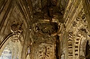
Radhanagar picture gallery edit
-
 Gopinath temple at Radhanagar
 -
 Gopinath temple
 -
 Gopinath temple
 -
 Singhabahini temple at Nabagram
 -
 Terracotta relief at Singhabahini temple
 -
 Terracotta relief at Singhabahini temple


References edit
- ^ Murshid, Ghulam. "Vidyasagar, Pundit Iswar Chandra". Banglapedia. Retrieved 24 July 2016.
- ^ "Ishwar Chandra Vidyasagar". www.whereincity.com. Retrieved 24 July 2016.
- ^ "District Human Development Report Paschim Medinipur, 2011". page 27-28. Department of Planning and Statistics, Government of West Bengal. Retrieved 10 September 2020.
- ^ "District Statistical Handbook Paschim Medinipur, 2013". Table 2.2, 2.4 (a). Department of Planning and Statistics. Retrieved 10 September 2020.
- ^ "CD block Wise Primary Census Abstract Data(PCA)". West Bengal – District-wise CD blocks. Registrar General and Census, India. Retrieved 25 August 2020.
- ^ "Radhanagar D. Vidyamandir U. Pr". Schools.org. Retrieved 25 August 2020.
- ^ McCutchion, David J., Late Mediaeval Temples of Bengal, first published 1972, reprinted 2017, page 47. The Asiatic Society, Kolkata, ISBN 978-93-81574-65-2
- ^ List of State Protected Monuments as reported by the Archaeological Survey of India Archived 2013-05-23 at the Wayback Machine.