This article needs additional citations for verification. (August 2020) |
Chandrakona is a town and a municipality in the Ghatal subdivision of Paschim Medinipur district in the state of West Bengal, India. The city is located between Ghatal and Garhbeta. Chandraketu was the founder of the kingdom of Chandrakona. In the Ain-E-Akbari, the 16th century Mughal document, it was mentioned as ‘Mana’.
Chandrakona | |
|---|---|
Town | |
 Prayag film city at Chandrakona | |
 Chandrakona Location in West Bengal, India  Chandrakona Chandrakona (India) | |
| Coordinates: 22°44′N 87°31′E / 22.73°N 87.52°E | |
| Country | |
| State | West Bengal |
| District | Paschim Medinipur |
| Government | |
| • Type | Municipality |
| • Body | Chandrakona Municipality |
| Area | |
| • Total | 16.58 km2 (6.40 sq mi) |
| Elevation | 28 m (92 ft) |
| Population (2011) | |
| • Total | 23,629 |
| • Density | 1,400/km2 (3,700/sq mi) |
| Languages | |
| • Official | Bengali, English |
| Time zone | UTC+5:30 (IST) |
| PIN | 721201 |
| Telephone code | 03225 |
| ISO 3166 code | IN-WB |
| Lok Sabha constituency | Arambagh |
| Vidhan Sabha constituency | Chandrakona |
Geography edit


5miles
M: municipal city/ town, R: rural/ urban centre, H: historical/ religious centre
Owing to space constraints in the small map, the actual locations in a larger map may vary slightly
Location edit
Chandrakona is located at 22°26′N 87°19′E / 22.44°N 87.31°E.[2] It has an average elevation of 28 metres (91 feet).
Area overview edit
Ishwar Chandra Vidyasagar, scholar, social reformer and a key figure of the Bengal Renaissance, was born at Birsingha on 26 September 1820.[3][4]
Ghatal subdivision, shown in the map alongside, has alluvial soils. Around 85% of the total cultivated area is cropped more than once.[5] It has a density of population of 1,099 per km2, but being a small subdivision only a little over a fifth of the people in the district reside in this subdivision. 14.33% of the population lives in urban areas and 86.67% lives in the rural areas.[6]
Note: The map alongside presents some of the notable locations in the subdivision. All places marked in the map are linked in the larger full screen map.
Demographics edit
As per 2011 Census of India, Chandrakona had a total population of 23,629 of which 11,977 (51%) were males and 11,652 (49%) were females. Population in the age range 0–6 years was 2,526. The total number of literate persons in Chandrakona was 17,564 (83.23% of the population over 6 years).[7]
As of 2001[update] India census,[8] Chandrakona Municipality had a population of 20,400. Males constitute 51% of the population and females 49%. Chandrakona has an average literacy rate of 66%, higher than the national average of 59.5%; with male literacy of 73% and female literacy of 58%. 14% of the population is under 6 years of age.
Civic administration edit
CD Block HQ edit
The headquarters of Chandrakona II Block are located at Chandrakona.[9]
Police station edit
Chandrakona police station has jurisdiction over Chandrakona, Khirpai and Ramjibanpur municipalities and Chandrakona I and Chandrakona II CD Blocks.[10][11]
Economy edit
The main economy is dependent on agriculture.
Some of the main agricultural products are rice, potato and jute. Only large scale industry here is formed by about 20 cold storages of potato. A few of the percentage of the people are government employees, School Teachers and employed in other small private sectors. The financial status of most of the people is in middle class and lower middle class category.
Banking edit
The oldest bank in Chandrakona is United Commercial Bank (UCO). Apart from this other three esteemed nationalized banks have branches in this city. Those are State Bank of India (SBI), United Bank of India (UBI) and Canara Bank. Also Punjab National Bank has a branch at Kalikapur, which is adjacent to Chandrakona municipality. From 1 April 2021 as per govt india directive united bank of india and oriental bank of commerce merged with Punjab national Bank, so the ubi branch in chandrakona town has become Punjab national bank's branch office. The private Bandhan Bank has an operational branch here as well. One of the famous co-operative bank in Bengal, "Tamluk Ghatal Central Co-operative Bank" has an older branch here, which assists people for more than two decades.
Other than those, few micro finance organizations operate from here. Their business and financial transactions basically deal with comparatively poor people in this city. Those are like "Chandrakona Samabay Samiti", "Bala Samabay Samiti", "Smartkart Financial Planners" etc.
The city has one CSP from Bank of India, which is located at Jayantipur.
Chandrakona Film City edit
The world's largest film city,[citation needed] the Prayag Film City, an integrated film-making complex and one-stop entertainment destination, is scheduled to open in phases beginning in 2012.
This section needs to be updated. (August 2020) |
See also - Ramoji Film City
History edit
A traceable history of Chandrakona and its adjoining areas begins to emerge about 690 A.D. when the Malla Dynasty was founded at Bishnupur. It must have been at that time a prosperous place, but not much else is certain. Historically, it was turbulent times; the anarchical period known as Matsyanyaya (মৎস্যন্যায়) in the history of Bengal. But tucked into the less-populated, forest covered fringes of the Chotonagpur plateau, the kingdom of Bishnupur lived by its own standards. And thanks to its excellent supply-system of agriculturally rich areas irrigated by river Shilaboti and its canals, Chandrakona grew in eminence, though gradually. 17th century scholar Jagamohan Pandit, in his Sanskrit geography-text Deshavali Vivriti, described Chandrakona as an important place in Bhan Desh - a land lying between the rivers Kangsabati and Shilaboti; a rich land where quality jute grew in abundance and sustained a renowned jute-textile industry. Cotton also grew, and the cotton-textile industry was almost equally famous. Its rivers and waterbodies yielded abundant fish and sustained a large population of fishermen. This prosperity was gained even as the Mughals and the Pathans clashed over the terrain for dominance till the former emerged victorious.

The political stability required for this prosperity came Chandrakona's way as the chief of a Rajput contingent, Indraketu, established almost independent rule here in the early 15th century. At about the same time another Rajput, Gajapati Singh, assumed the rule of Bagri, lying west of Chandrakona. These two tiny kingdoms fought each other several times during the next centuries, so that their family trees and fate became inextricably entangled.
Chandrakona thrived during the century-long rule of the Ketu kings. The town probably got its name from the third of them - Chandraketu. Jogesh Chandra Basu, a scholar on the history of Medinipur, says that Chandrakona was previously known as Mana. Chandraketu ruled during the early decades of the fifteenth century. The Gurudwara of Chandrakona dates from this time. Guru Nanakji and Mardanaji came to Chandrakona in 1510 on their way to Puri and set up a manji here which has now evolved into a gurudwara revered and visited by Sikhs from different parts of the state.
During Mughal rule Chandrakona retained its status of a semi-independent kingdom. By the middle of the 16th century Birbhan Singh, a Chauhan, began a new line of rulers. They efficiently ruled over the town for about 150 years, till in the early eighteenth century Maharaj Kirtichandra of Burdwan overthrew Raghunath Singh, the last of them. However, most of what constitutes the glory of Chandrakona, its temple complexes and its large tanks, tell us of the interest the Bhan rulers took in public works as well as of their patronage of religion and art. The legendary prosperity of Chandrakona, a town with fifty-two market places and a network of fifty-three inter-linked roads, owed itself to the efficient administration of the Bhan rulers.
Chandrakona came under the British East India Company in 1760. The textile industry was most hardly hit as a consequence. The famous weavers of Chandrakona had either to re-locate or to take up farming as profession. However, the town held its own as an important centre of trade and commerce. In the nineteenth century Chandrakona was known for producing quality brass utensils. It got its municipal administration in 1869 and Beverley's Census Report of Bengal, 1872, records that the town had a population of 21,311; that is to say, almost equal to its present population. Once a part of Hooghly district, the town was incorporated into the Ghatal subdivision of Medinipur district in 1872. Over the next six decades the population of the town depleted alarmingly. In 1931, it was reported to have a population of a little over 6000.

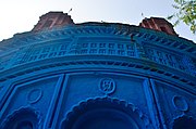
Like its more famous neighbour Bishnupur, Chandrakona may also be termed a temple town. Its temples display the blending of several architectural styles - the Rekha-Deul, the char-chala and at-chala styles of Bengal, and so on. Some of them, like the one at Mitrasenpur, are decorated with excellent terracotta plates depicting events from the Mahabharata and the Avatars of Vishnu. The pancharatna temple of Malleswar is also a grand structure. But most of these temples have become dilapidated, and hardly any effort is being made to preserve these heritage structures. In addition to the temples, there are three Asthals i.e. monastic establishments of the Sri Vaishnava Ramanuja sampradaya hailing from the spiritual lineage of the Ahobila Mutt.

The eminence of the Dharmathakur cult in Chandrakona points to the co-existence for centuries of Brahminical and non-Brahminical religions. Several Dharmathakur images are found at Gobindapur, Narahipur and Jayantipur localities of Chandrakona. The Shivagajan festival at the end of the Bengali year, one of the major religious festivals in Chandrakona, is also reminiscent of pre-Aryan rituals.
Transportation edit
Chandrakona is well connected by roads/highways to state capital Kolkata and other important towns of South Bengal including Medinipur (42 km South West), Burdwan, Bankura, Haldia, Kharagpur, and Tarakeswar. State Highway 4 (West Bengal) connects the town to National Highway 6 (Kolkata-Mumbai) at Mechogram (60 km South East). The nearest railway station is Chandrakona Road railway station, 20 km West. Locals use bicycles and motorbikes for transportation within the town. Rickshaws, Battery operated rickshaws and cabs are also available.
Education edit
There are schools and colleges in Chandrakona Town. Institute of Science & Technology is a technology-oriented private college established in 2005. This institute is affiliated to Wbut. It is an emerging engineering and management college in West Medinipur district as well as in West Bengal. There is also another college named Chandrakona Vidyasagar Mahavidyalaya, which is under Vidyasagar University. The schools of Chandrakona Town are Chandrakona Jirat High School, Kalyanshri J D Girls School, Malleswarpur Sarada Vidyapith High School and Atasi Smriti High School. There is also a non-governmental educational organization to help the poor meritorious students named Rakshabandhan For Education. Under Chandrakona Block-II, there is a village named Kiageria, 3 km from the town. In this village, a non-conventional school called School in the Cloud has been organized and established by Sarbik Palli Kalyan Kendra, a 27-year-old non-governmental organization. This school allows village children aged four to fourteen years old to learn subjects on their own through the Internet and Skype without teachers (self-organized learning environment). This system has been introduced worldwide by Professor Dr. Sugata Mitra, 2013 TED Talks prize winner, of Newcastle University, UK.
Health edit
There is a hospital in Chandrakona town. People of Chandrakona and its nearest areas mainly depend on that hospital.
Culture edit
"The number of temples that are still there in Chandrakona is a matter of wonder." - Binoy Ghosh, historian[12]
Chandrakona and its surrounding areas have numerous temples, some built of laterite, and some are brick-built. These temples are superb articulation of local architectural styles and present a wide array of terracotta decoration. Unfortunately, many of the temples have fallen, a few have been distastefully painted or spoiled by inexperienced restoration and others lie uncared for. Chandrakona has a rich heritage and can successfully share it with others.[13]
David J. McCutchion mentions:[14]
- The Jor-Bangla temple at Dakshinbazar as laterite built, possibly in the 17th century, with extensive stucco work, measuring 28’ 4” x 26’.
- The Jhulanmandir in the Thakurbari as a char-chala on an elongated base, laterite built, largely plain, measuring 30’ 9” x 20’.
- The Lalji temple as a low-towered at-chala, laterite-built with stucco figures, measuring, 36’9” x 23’ 9”.
- The Mallesvara temple as a pancha-ratna with ridged rekha turrets and porch on triple archway, laterite-built possibly in the 18th century, with stucco figures, measuring around 26’ square.
- The Santinatha Shiva temple at Mitrasenpur, built in 1828, with rich terracotta, measuring 19’ 6” square.
- The Parvatinatha temple as a standard saptdasa-ratna (17 pinacled), built in the 19th century, with rich terracotta and stucco, measuring around 21’ 6”.
- The Shiva temple, beside Kankali temple, 19th century built, with terracotta decorations, measuring 9' 1" square.
- Bardhan's temple near Thakurbari as a small flat roofed or chandni type, laterite-built, plain, measuring 12’ 9” x 19’ 7”.
- The Anantadeva temple at Mitrasenpur as a small flat roofed or chandni type, with terracotta decorations, built in 1899, measuring 12’ 10”
- The Dadhivamna temple in Gobindapur as a small flat roofed or chandni type, with terracotta decorations, measuring 14’3” x 13’ 10”.
- The Jagannath temple in Gosai Bazar as a small flat roofed or chandni type, plain, measuring 19’ 5” x 17’ 6”.
- The Raghunatha temple at Gazipur as a flat roofed or chandni type, with curved cornice, laterite-built with stucco work, measuring 16’ 3” x 16’ 6”.
- The Radhaballava temple at Mitrasenpur as a flat roofed or chandni type, with curved cornice, laterite-built in 1781, with stucco work, measuring 17’ 2” x 16’ 8”.
- The Raghunatha temple as rekha-deul or pirha-deul having a pirha porch with base dimension larger than the main temple, laterite built with stucco figures, measuring 15’ 6” square + 19’ 2” square.
See also edit
-
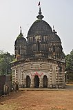 Malleswara Shiva Temple – one of the oldest temples in Chandrakona
 -
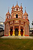
 Chandrakona Jorbangla Temple - built in the 17th century it is one of the earliest Jorbangla temples in Bengal
 -
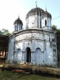
 Shantinatha Shiva Temple – with exquisite terracotta relief
 -
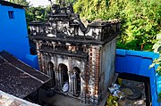
 Parvatinatha Temple – large 17-pinnacled show-piece of Chandrakona
 -
 Jayantipur, located nearby in Chandrakona II CD block
 -
 Baikunthapur, located nearby in Chandrakona II CD block


Chandrakona picture gallery edit
-
 Anantadeva dalan temple in Mitrasenpur, built in 1899
 -
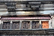 Terracotta and stucco work in Anantadeava temple
 -
 Nava-ratna Buro Shiva temple at Dakshin Bazar
 -
 Terracotta plaques and stucco work at Buro Shiva temple
 -
 At-chala Khalsa Shiva temple built in 1865 by tambuli merchants
 -
 Pancha-ratna Radha Gobinda temple at Ilalmbazar, belongs to the Chabri family, built in 1870
 -
 Radhagobinda temple – unskilled restoration work has ruined terracotta plaques
 -
 Plaque on the gate of the enclosure of Radhagobinda temple
 -
 Nava-ratna Radha Rasikraya temple at Lalbazar, built in the 19th century
 -
 Raghunathbari Thakubari built in 1831 by Maharaja Tej Chandra of Burdwan
 -
 At-chala Shantinath Shiva temple at Gosaibazar
 -
 Pancha-ratna Santinath Shiva temple at Ilambazar


Healthcare edit
Chandrakona Rural Hospital, with 60 beds at Chandrakona, is the major government Chandrakona II CD block.[15]
References edit
- ^ "Chandrakona Info".
- ^ Falling Rain Genomics, Inc - Chandrakona
- ^ Murshid, Ghulam. "Vidyasagar, Pundit Iswar Chandra". Banglapedia. Retrieved 24 July 2016.
- ^ "Ishwar Chandra Vidyasagar". www.whereincity.com. Retrieved 24 July 2016.
- ^ "District Human Development Report Paschim Medinipur, 2011". page 27-28. Department of Planning and Statistics, Government of West Bengal. Retrieved 10 September 2020.
- ^ "District Statistical Handbook Paschim Medinipur, 2013". Table 2.2, 2.4 (a). Department of Planning and Statistics. Retrieved 10 September 2020.
- ^ "2011 Census – Primary Census Abstract Data Tables". West Bengal – District-wise. Registrar General and Census Commissioner, India. Retrieved 28 August 2020.
- ^ "Census of India 2001: Data from the 2001 Census, including cities, villages and towns (Provisional)". Census Commission of India. Archived from the original on 16 June 2004. Retrieved 1 November 2008.
- ^ "District Census Handbook: Paschim Medinipur" (PDF). Map of Paschim Medinipur with CD Block HQs and Police Stations (on the fifth page). Directorate of Census Operations, West Bengal, 2011. Retrieved 20 November 2016.
- ^ "District Statistical Handbook 2014 Paschim Medinipur". Tables 2.1, 2.2. Department of Planning and Statistics, Government of West Bengal. Retrieved 14 September 2020.
- ^ "District at a Glance". Paschim Medinipur District Police. Archived from the original on 27 October 2016. Retrieved 27 October 2016.
- ^ Ghosh, Binoy, Paschim Banger Sanskriti, (in Bengali), part II, 1976 edition, pages 95- 97, Prakash Bhaban, Kolkata.
- ^ Gupta, Amitabha. "The Crumbling Temples of Chandrakona". Live History India, 4 May 2020. Retrieved 30 August 2020.
- ^ McCutchion, David J., Late Mediaeval Temples of Bengal, first published 1972, reprinted 2017, pages 7,27, 32, 38, 39, 46, 52, 55, 63, 64, 69. The Asiatic Society, Kolkata, ISBN 978-93-81574-65-2
- ^ "Health & Family Welfare Department" (PDF). Health Statistics – Rural Hospitals. Government of West Bengal. Retrieved 1 September 2020.
External links edit
- Noticeboard of Medinipur... News, Photo Gallery, Classified and many more
- Paschim Medinipur District Official Website
- Purba Medinipur District Official Website
- Midnapore - Website for East and West Midnapore
- On temples of Midnapur
- Institute of Science & Technology, Chandrakona
- We Restore, Let's preserve our heritage (An initiative, demanding the conservation of the historical structures of medieval ages of Chandrakona like Palace of King, various temples etc.)