Introduction Western Australia (commonly abbreviated as WA) is a state of Australia occupying the western third of the land area of Australia, excluding external territories. It is bounded by the Indian Ocean to the north and west, the Southern Ocean to the south, the Northern Territory to the north-east, and South Australia to the south-east. With a total land area of 2,527,013 square kilometres (975,685 sq mi), Western Australia is Australia's largest state as well as the second-largest subdivision of any country on Earth, surpassed only by the Sakha Republic in eastern Russia. the state has 2.76 million inhabitants—11 percent of the national total. The vast majority (92 percent) live in the south-west corner; 79 percent of the population lives in the Perth area, leaving the remainder of the state sparsely populated. The first Europeans to visit Western Australia belonged to the Dutch Dirk Hartog expedition, who visited the Western Australian coast in 1616. The first permanent European colony in what is today Western Australia occurred following the landing by Major Edmund Lockyer on 26 December 1826 of an expedition on behalf of the New South Wales colonial government. Lockyer established a convict-supported military garrison at King George III Sound, at present-day Albany, and on 21 January 1827 he formally took possession for the British Crown of the western part of the continent that was not already claimed by the Crown. This was followed by the establishment of the Swan River Colony in 1829, including the site of the present-day capital, Perth. (Full article...)
|


(Northern
Territory) |
 Good articles -
-

Tropical Cyclone Herbie was the only known tropical system to impact Western Australia during the month of May on record. The final cyclone of the 1987–88 Australian region cyclone season, Herbie was first identified northwest of the Cocos Islands on 17 May. The following day, the system was classified as a tropical low by the Australian Bureau of Meteorology and intensified into a Category 1 cyclone later that day. Several hours after this upgrade, the storm attained its initial peak intensity with winds of 75 km/h (45 mph 10-minute sustained). Around the same time, the Joint Typhoon Warning Center classified Herbie as Tropical Storm 21S.
On 19 May, the cyclone formed a new low-pressure center and relocated roughly 300 km (190 mi) south. Shortly thereafter, the storm began to accelerate towards the southeast and started to undergo an extratropical transition. Early on 21 May, Herbie made landfall in Shark Bay before losing its identity the following day over the Great Australian Bight. Although a weak storm, Herbie brought flooding rains and severe dust storms to portions of Western Australia. Additionally, a 30,000 ton freighter broke in half amidst rough seas produced by the storm. Total losses from the storm reached A$20 million (US$15.6 million). Due to the significant damage wrought by Herbie, the name was retired following its use. (Full article...) -

The sandbar as viewed from Point Walter.
Point Walter (Noongar: Dyoondalup) is a point on the Swan River, Western Australia, notable for its large sandbar that extends into the river. It is located on the southern shore of Melville Water, and forms its western end. Point Walter is located in the suburb of Bicton, approximately 12 kilometres (7 mi) south of the Perth central business district, and 7 kilometres (4 mi) north-east of Fremantle, and is on the opposite side of the river to the suburbs of Mosman Park, Peppermint Grove, and Dalkeith.
Point Walter is a site of Aboriginal Australian heritage, both for its place in the Dreamtime and because of the local Whadjuk people's historical activities at the site. Named in 1827 by James Stirling, it was popular among the public for its variety of recreational activities and its facilities, such as tea rooms, a bathing house and a tavern. Through a series of events, the point suffered a drop in patronage from the late 19th century to World War II. At that time, it was rehabilitated from a state of disrepair, and an army camp was built on the premises, which was later transformed into a migrant settlement camp. Since the migrant camp's closure in 1972, the facilities have been used for multiple activities. (Full article...) -
Aubin Grove railway station is a suburban railway station serving Atwell, Aubin Grove, Hammond Park and Success, which are suburbs of Perth, Western Australia. It is on the Mandurah line, which is part of the Transperth network, and is located immediately north of Russell Road in the median of the Kwinana Freeway. It has two platform faces on a singular island platform, which is linked to either side of the freeway by a pedestrian overpass. Services run every 10 minutes during peak and every 15 minutes between peak. The journey to Perth station is 23.8 kilometres (14.8 mi) and takes 21 minutes. The station has a bus interchange with four bus stands and seven regular bus routes.
Construction of the station was promised by both major political parties ahead of the 2013 Western Australian state election. A tender was released for the station's construction in July 2014, with a projected cost of A$80 million for the whole project, including the purchase of two Transperth B-series trains. The design contract was awarded in February 2015 to a joint venture between Coniglio Ainsworth Architects and M. P. S. Architects. The scope of the project was broadened in April 2015 to include the widening of the Russell Road bridge over the freeway, which increased the project budget to $105 million. Construction on the station began in March 2016, and it was opened on 23 April 2017, with the final cost being $125 million. (Full article...) -
Bayswater railway station is a suburban rail station in Bayswater, a suburb of Perth, Western Australia. It is the junction station for Transperth's Midland and Airport lines, and the Morley–Ellenbrook line when it opens in late 2024.
The station first opened in 1896 on the Perth to Midland railway with two side platforms and an adjacent goods yard. It served as the junction station for the Belmont spur line between 1896 and 1956. Bayswater station was rebuilt as an island platform just to the north in the late 1960s when the Midland line was converted from narrow gauge to dual gauge; the standard gauge trains were unable to fit between the side platforms. Around that time, the goods yard closed. (Full article...) -
The history of Fremantle Prison, a former Australian prison in Fremantle, Western Australia, extends from its construction as a prison for convicts, using convict labour, in the 1850s, through to its modern-day usage as a tourist attraction. The design for Fremantle Prison was based on the Pentonville Prison in Britain, and it would be the longest, tallest prison cell block in the southern hemisphere. Construction began in 1851, and was completed by the end of 1859. The prison was transferred to the colonial government in 1886 for use for locally sentenced prisoners. Following a Royal Commission held in 1898−99, some changes were made to Fremantle Prison, including knocking down the inner wall between two cells, introducing a prisoner classification system, and constructing internal walls in the main block to create four separate divisions. A new cell block, New Division, was completed in 1907 and occupied in 1908.
Following another Royal Commission investigation 1911, there were some rapid changes in prison policy. A new superintendent with outside experience, Hugh Hann, was appointed, and supported by the newly elected Labor government interested in penal reform. Fremantle Prison was partially used as a military gaol during both world wars. The World War II takeover necessitated the commissioning of Barton's Mill Prison in 1942, which remained opened after the war. Pardelup Prison Farm was another prison outstation established in 1927 to reduce overcrowding at Fremantle. Both facilities were part of reforms made to the prison system, but significant changes to the operation of Fremantle Prison did not begin until the 1960s. Comptroller General Colin Campbell introduced expedient prisoner assessments, officer training, work release programs, and social workers and welfare officers. (Full article...) -
High Wycombe railway station is a Transperth commuter rail station in Perth, Western Australia. The station is the eastern terminus of the Airport line and was one of three stations built as part of the Forrestfield–Airport Link project.
The station was originally known as Forrestfield station during planning and construction. The contract for the Forrestfield–Airport Link, which consists of 8 kilometres (5 mi) of twin bored tunnels and three new stations, was awarded to Salini Impregilo and NRW Pty Ltd in April 2016. High Wycombe station itself was constructed above ground, with the line entering a tunnel just north of the station. Construction began in November 2016, with works initially focussing on building the tunnel dive structure. Tunnelling began in July 2017, and construction of the station itself had begun by November 2017. For much of the construction period, the site contained infrastructure to support the tunnelling operation. (Full article...) -
Severe Tropical Cyclone Alby was regarded as the most devastating tropical cyclone to impact southwestern Western Australia on record. Forming out of an area of low pressure on 27 March 1978, Alby steadily developed as it tracked southwestward, parallel to Western Australia. Between 1 and 2 April, the storm quickly intensified and attained its peak intensity as a Category 5 cyclone on the Australian cyclone intensity scale. After turning to the southeast, the storm underwent an extratropical transition as it neared Cape Leeuwin. The storm brushed the cape on 4 April, bringing hurricane-force winds, before rapidly losing its identity the following day.
In Western Australia, the combination of Alby's fast movement and hurricane-force winds caused widespread damage. Along the coast, large swells flooded low-lying areas and numerous homes lost their roofs from high winds. Further inland, bushfires were worsened by the storm as it brought little rain, generally less than 20 mm (0.79 in) along the coast. These fires burned roughly 114,000 hectares (281,700 acres). Cyclone Alby and the associated brushfires caused five deaths, with the heaviest damage in the town of Albany, Western Australia. A report at the time noted that "The Perth metropolitan area and nearly every town from Geraldton to Albany was extensively damaged." The resulting damage was extensive, with monetary losses reaching A$50 milelion (US$45 million). According to a Canadian newspaper, the Associated Press reported initially that officials in Perth said that "A tropical cyclone Tuesday tore across the southwestern tip of Australia, killing at least five persons and sparking brushfires that destroyed two towns,", but the two towns supposedly destroyed by fire were not identified, nor was there a report in the local press or subsequent investigations. (Full article...) -
Butler railway station is a suburban railway station in Butler, a suburb of Perth, Western Australia. It is the terminus of the Joondalup line, which is on the Transperth rail network. Planning for the Joondalup line in the Butler area began in the late 1990s. The station was built as part of a A$240 million extension of the Joondalup line from Clarkson to Butler. Construction began on the station on 16 July 2012, and was completed on 16 May 2014, opening on 21 September 2014. On 15 July 2024, an extension of the Joondalup line from Butler to Yanchep will open.
Butler station has two side platforms situated in a cutting below the surrounding ground level. It is accessed from a ground-level concourse. Services run every 10 minutes during peak and every 15 minutes between peak. The journey to Perth Underground station is 40.7 kilometres (25.3 mi) and takes 38 minutes. The station is served by six regular bus routes, operated by Swan Transit under contract. To the south, these bus routes link to Clarkson station, traversing through several suburbs along the way. To the north, these bus routes go as far as Two Rocks, on the northern edge of the Perth metropolitan region. (Full article...) -
Redcliffe railway station is a station for underground commuter rail services in Redcliffe, east of Perth, Western Australia. The station is one of three stations that were built as part of the Forrestfield–Airport Link project and is served by Transperth's Airport line services.
The contract for the Forrestfield–Airport Link, which consists of 8 kilometres (5.0 mi) of twin bored tunnels and three new stations, was awarded to Salini Impregilo and NRW Pty Ltd in April 2016. Forward works, which included the permanent closure of Brearley Avenue between Great Eastern Highway and Dunreath Drive, began in 2016. Construction began in mid-2017, and by June 2018, excavation was complete. The two tunnel boring machines (TBMs) reached the station in mid-2019, having tunnelled from High Wycombe, and left tunnelling towards Bayswater after several weeks of maintenance. Construction of the station infrastructure followed. (Full article...) -

Operation Mosaic was a series of two British nuclear tests conducted in the Montebello Islands in Western Australia on 16 May and 19 June 1956. These tests followed the Operation Totem series and preceded the Operation Buffalo series. The second test in the series was the largest ever conducted in Australia.
The purpose of the tests was to explore increasing the yield of British nuclear weapons through boosting with lithium-6 and deuterium, and the use of a natural uranium tamper. Although a boosted fission weapon is not a hydrogen bomb, which the British Government had agreed would not be tested in Australia, the tests were connected with the British hydrogen bomb programme. (Full article...) -
Kardinya is a suburb 13 kilometres (8 mi) south-southwest of the central business district of Perth, the capital of Western Australia. It is in the City of Melville local government area. It is predominantly a low-density residential suburb consisting of single-family detached homes. There is a commercial area in the centre of the suburb, with a shopping centre and several other shops. In the northwest is a small light industrial area. Kardinya has a population of 8,730 people.
Before European settlement, the area was inhabited by the Beeliar group of the Whadjuk Noongar people. Kardinya did not attract any interest from Europeans when the Swan River Colony was founded in 1829, as it was far away from any river and was not fertile. European use of Kardinya began in 1870 when fourteen lots were allocated to Pensioner Guards. These lots were used for piggeries, poultry farms and vineyards. In 1904, a large amount of land in the area was set aside as endowment land for the University of Western Australia. In the 1920s, this land started to be used as a pine plantation, known as the Applecross Pine Plantation, and, after 1947, the Somerville Pine Plantation. The suburb was formally gazetted on 16 June 1961. From 1967 to the early 1980s, suburban development occurred in Kardinya. (Full article...) -
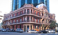
The Palace Hotel in Perth, Western Australia, is a landmark three-storey heritage listed building located in the city's central business district. Originally built in 1897 as a hotel during the gold rush period of Western Australia's history, it was converted to banking chambers and offices in the 1980s and now accommodates the Perth headquarters of Woods Bagot, Adapptor and Hatchd. The building is located on the most prominent intersection in the financial district of the city, at the corner of St Georges Terrace and William Street.
When the hotel opened for business on 18 March 1897 it was, although slightly smaller than some of its contemporary buildings in other capital cities in Australasia, described as "... one of the most beautiful and elegant hotels in Australasia". Other praise included: "... redolent of the bourgeois luxury and splendour of the Paris of Napoleon III" and later "... in its day, as sumptuous a hostelry as any in Melbourne or Sydney." It operated as licensed premises from 1897 until 1981. (Full article...) -
The 11th Battalion was an Australian Army battalion that was among the first infantry units raised during World War I for the First Australian Imperial Force. It was the first battalion recruited in Western Australia, and following a brief training period in Perth, the battalion sailed to Egypt where it undertook four months of intensive training. In April 1915 it took part in the invasion of the Gallipoli Peninsula, landing at Anzac Cove. In August 1915 the battalion was in action in the Battle of Lone Pine. Following the withdrawal from Gallipoli, the battalion returned to Egypt where it was split to help form the 51st Battalion. In March 1916, the battalion was deployed to the Western Front in France and Belgium where it took part in trench warfare until the end of the war in November 1918.
The battalion was disbanded in 1919, but since 1921 has been re-activated and merged several times as a reserve unit, initially as the 11th Battalion (City of Perth Regiment), which fought a brief campaign against the Japanese on New Britain during World War II. Other units that have maintained the traditions of the original 11th Battalion include the 11th/44th Battalion (City of Perth Regiment), 'A' (City of Perth) Company, 1st Battalion, Royal Western Australia Regiment and the current 11th/28th Battalion, Royal Western Australia Regiment. (Full article...) -
Central Park is a 51-storey office tower in Perth, Western Australia. The building measures 226 m (741 ft) from its base at St Georges Terrace to the roof, and 249 m (817 ft) to the tip of its communications mast. Upon its completion in 1992, the tower became the tallest building in Perth, and was the 4th tallest in Australia from then till 2005. It is also currently the sixteenth tallest building in Australia (tied with the Infinity Tower) and the tallest building in the western half of Australia.
The approval of the tower was controversial due to the plot ratio concessions made by the Perth City Council to the developers. These concessions enabled the developers to construct a tower more than twice the height which would otherwise be allowable on the site. There was also opposition to the Council's decision to ignore its own town planning experts in allowing a large car park to be constructed underneath the site. (Full article...) -
John Biase D'Orazio (5 September 1955 – 11 April 2011) was an Australian politician who served as the member for Ballajura in the Western Australian Legislative Assembly from 10 February 2001 to 6 September 2008. He was a minister in the governments of Geoff Gallop and Alan Carpenter, and a member of the Labor Party until 29 August 2006, when he resigned following several controversies. Born to Italian immigrants, D'Orazio grew up on a market garden in the Perth suburb of Bayswater. He studied pharmacy at the Western Australian Institute of Technology, later opening his own pharmacy business. In 1981, he was elected to the City of Bayswater council, and in 1984, he became the mayor of Bayswater, in which position he served until 2001.
At the 2001 Western Australian state election, D'Orazio was elected to the seat of Ballajura, beating the Liberal incumbent Rhonda Parker. Following the 2005 state election, he was promoted to cabinet by Premier Geoff Gallop, becoming the minister for justice and minister for small business. In February 2006, after Alan Carpenter became premier, D'Orazio was appointed as the minister for police and emergency services, minister for justice, and minister for community safety. (Full article...)


Did you know (auto-generated)

- ... that Bill Dunn, an Indigenous Australian pastoralist approaching retirement, sold his station at half-price to the Jigalong community despite receiving full-price offers from non-Indigenous people?
- ... that Western Australia was the second Australian state to legalise voluntary assisted dying?
- ... that Mertome Village in Bayswater, Western Australia was the first aged care complex to be built by a local government in Australia?
- ... that politician John D'Orazio helped to secure a three-year trial of daylight saving time in Western Australia?
- ... that Nick Goiran, a member of the Western Australian Legislative Council, proposed 357 amendments to a voluntary assisted dying bill?
- ... that the search for a lost radioactive capsule along a 1,400-kilometre (870 mi) stretch of road in Western Australia was likened to looking for a needle in a haystack?
Categories

More portals
More did you know...

- ...that when the 1987 America's Cup was raced off Fremantle, Western Australia it was the first time for 132 years that the regatta had not been hosted by the New York Yacht Club?
- ...that the original Victoria Dam, constructed in 1891, was the first dam in Western Australia, and it stood for almost 100 years before being replaced with the current dam?
- ...that Anglican bishop Kay Goldsworthy was consecrated as the first woman bishop of any Australian church on 22 May 2008?
Related WikiProjects

Things you can do
Here are some tasks you can do to help with WikiProject Western Australia:
Associated Wikimedia
The following Wikimedia Foundation sister projects provide more on this subject:
-
 Commons
Free media repository -
 Wikibooks
Free textbooks and manuals -
 Wikidata
Free knowledge base -
 Wikinews
Free-content news -
 Wikiquote
Collection of quotations -
 Wikisource
Free-content library -
 Wikispecies
Directory of species -
 Wikiversity
Free learning tools -
 Wikivoyage
Free travel guide -
 Wiktionary
Dictionary and thesaurus


