The New South Wales Portal


New South Wales (commonly abbreviated as NSW) is a state on the east coast of Australia. It borders Queensland to the north, Victoria to the south, and South Australia to the west. Its coast borders the Coral and Tasman Seas to the east. The Australian Capital Territory and Jervis Bay Territory are enclaves within the state. New South Wales' state capital is Sydney, which is also Australia's most populous city. , the population of New South Wales was over 8.3 million, making it Australia's most populous state. Almost two-thirds of the state's population, 5.3 million, live in the Greater Sydney area.
The Colony of New South Wales was founded as a British penal colony in 1788. It originally comprised more than half of the Australian mainland with its western boundary set at 129th meridian east in 1825. The colony then also included the island territories of Van Diemen's Land, Lord Howe Island, and Norfolk Island. During the 19th century, most of the colony's area was detached to form separate British colonies that eventually became the various states and territories of Australia and, arguably, New Zealand. The Swan River Colony (later called the Colony of Western Australia) was never administered as part of New South Wales. (Full article...)
 Recognized content -
-


Grevillea juniperina, commonly known as juniper- or juniper-leaf grevillea or prickly spider-flower, is a plant of the family Proteaceae native to eastern New South Wales and southeastern Queensland in Australia. Scottish botanist Robert Brown described the species in 1810, and seven subspecies are recognised. One subspecies, G. j. juniperina, is restricted to Western Sydney and environs and is threatened by loss of habitat and housing development.
A small, prickly-leaved shrub between 0.2–3 m (0.66–9.84 ft) high, G. juniperina generally grows on clay-based or alluvial soils in eucalypt woodland. The flower heads, known as inflorescences, appear from winter to early summer and are red, orange or yellow. Birds visit and pollinate the flowers. Grevillea juniperina plants are killed by bushfire, regenerating afterwards from seed. Grevillea juniperina adapts readily to cultivation and has been important in horticulture as it is the parent of many popular garden hybrids. (Full article...) -

Library punchbowl showing beach where Circular Quay is now located
The Sydney punchbowls, made in China during the Jiaqing Emperor's reign (1796–1820) over the mid-Qing dynasty, are the only two known examples of Chinese export porcelain hand painted with Sydney scenes and dating from the Macquarie era. The bowls were procured in Canton about three decades after the First Fleet's arrival at Port Jackson where the British settlement at Sydney Cove was established in 1788. They also represent the trading between Australia and China via India at the time. Even though decorated punchbowls were prestigious items used for drinking punch at social gatherings during the 18th and 19th centuries, it is not known who originally commissioned these bowls or what special occasion they were made for.
The punchbowls are a 'harlequin pair', similar but not exactly matching. The bowls have been donated independently, one to the State Library of New South Wales (SLNSW) in 1926 and the other to the Australian National Maritime Museum (ANMM) in 2006. The Library bowl is the more widely known of the pair. Its earliest provenance places it in England in the late 1840s, where it is said to originally have been commissioned for William Bligh; another source suggests Henry Colden Antill. It passed through several owners in Britain before it was presented to the State Library. The Museum bowl's first provenance is from England in 1932 and it has been suggested that it was made to the order of Arthur Phillip. Its whereabouts were unknown until it appeared in the Newark Museum, United States, in 1988, on loan from Peter Frelinghuysen Jr. Through donations, the Maritime Museum later acquired the punchbowl from Frelinghuysen. (Full article...) -
Wagga Wagga (/ˌwɒɡə ˈwɒɡə/; informally called Wagga) is a major regional city in the Riverina region of New South Wales, Australia. Straddling the Murrumbidgee River, with an urban population of more than 57,003 as of 2021, Wagga Wagga is the state's second largest inland city after Maitland, and is an important agricultural, military, and transport hub of Australia. The ninth largest inland city in Australia, Wagga Wagga is located midway between the two largest cities in Australia—Sydney and Melbourne—and is the major regional centre for the Riverina and South West Slopes regions.
The central business district is focused around the commercial and recreational grid bounded by Best and Tarcutta Streets and the Murrumbidgee River and the Sturt Highway. The main shopping street of Wagga is Baylis Street which becomes Fitzmaurice Street at the northern end. Wagga is accessible from Sydney via the Sturt and Hume Highways, Adelaide via the Sturt Highway and Albury and Melbourne via the Olympic Highway and Hume Highway. Wagga is in an alluvial valley and much of the city has a problem with urban salinity. (Full article...) -
Isopogon anethifolius, commonly known as narrow-leaf drumsticks or narrow-leafed drumsticks, is a shrub in the family Proteaceae. The species is found only in coastal areas near Sydney in New South Wales, and to the immediate west. It occurs naturally in woodland, open forest and heathland on sandstone soils. An upright shrub, it can reach to 3 m (9.8 ft) in height, with terete leaves that are divided and narrow. The yellow flowers appear in the Spring, from September to December, and are prominently displayed. They are followed by round grey cones, which give the plant its common name of drumsticks. The small hairy seeds are found in the old flower parts.
Isopogon anethifolius regenerates after bushfire by resprouting from its woody base, known as a lignotuber, as well as from seed. It was described by Richard Salisbury in 1796, and was first grown in the United Kingdom the same year. One of the easiest members of the genus Isopogon to grow in cultivation, I. anethifolius grows readily in the garden if located in a sunny or part-shaded spot with sandy soil and good drainage. (Full article...) -
Lord Howe Island (/haʊ/; formerly Lord Howe's Island) is an irregularly crescent-shaped volcanic remnant in the Tasman Sea between Australia and New Zealand, part of the Australian state of New South Wales. It lies 600 km (320 nmi) directly east of mainland Port Macquarie, 780 km (420 nmi) northeast of Sydney, and about 900 km (490 nmi) southwest of Norfolk Island. It is about 10 km (6.2 mi) long and between 0.3 and 2.0 km (0.19 and 1.24 mi) wide with an area of 14.55 km2 (3,600 acres), though just 3.98 km2 (980 acres) of that comprise the low-lying developed part of the island.
Along the west coast is a sandy semi-enclosed sheltered coral reef lagoon. Most of the population lives in the north, while the south is dominated by forested hills rising to the highest point on the island, Mount Gower (875 m, 2,871 ft). The Lord Howe Island Group comprises 28 islands, islets, and rocks. Apart from Lord Howe Island itself, the most notable of these is the volcanic and uninhabited Ball's Pyramid about 23 km (14 mi; 12 nmi) to the southeast of Howe. To the north lies a cluster of seven small uninhabited islands called the Admiralty Group. (Full article...) -

Lambertia formosa, commonly known as mountain devil, is a shrub of the family Proteaceae, endemic to New South Wales, Australia. First described in 1798 by English botanist James Edward Smith, it is the type species of the small genus Lambertia. It is generally found in heathland or open forest, growing in sandstone-based soils. It grows as a multistemmed shrub to around 2 m (7 ft) with a woody base known as a lignotuber, from which it regrows after bushfire. It has stiff narrow leaves, and the pink to red flowerheads, made up of seven individual tubular flowers, generally appear in spring and summer. It gains its common name from the horned woody follicles, which were used to make small devil-figures.
The flowers hold profuse amounts of nectar and are pollinated by honeyeaters. Although L. formosa is uncommon in cultivation, it is straightforward to grow in soils with good drainage and a partly shaded to sunny aspect. It is readily propagated by seed. Unlike all other members of the genus Lambertia, L. formosa is greatly resistant to the soil pathogen Phytophthora cinnamomi. (Full article...) -
Isopogon anemonifolius, commonly known as broad-leaved drumsticks, is a shrub of the family Proteaceae that is native only to eastern New South Wales in Australia. It occurs naturally in woodland, open forest, and heathland on sandstone soils. I. anemonifolius usually ranges between one and two metres in height, and is generally smaller in exposed heathland. Its leaves are divided and narrow, though broader than those of the related Isopogon anethifolius, and have a purplish tinge during the cooler months. The yellow flowers appear during late spring or early summer and are displayed prominently. They are followed by round grey cones, which give the plant its common name drumsticks. The small hairy seeds are found in the old flower parts.
A long-lived plant reaching an age of up to 60 years, I. anemonifolius resprouts from its woody base, known as a lignotuber, after bushfire. Seedlings appear in the year following a fire. Although I. anemonifolius was collected by Daniel Solander in 1770, it was not described until 1796 by Richard Salisbury. Several varieties have been named, though none are now recognised as distinct. It was first cultivated in the United Kingdom in 1791. I. anemonifolius grows readily in the garden if located in a sunny or part-shaded spot with sandy soil and good drainage. (Full article...) -
The 1999 Sydney hailstorm was the costliest natural disaster in Australian insurance history, causing extensive damage along the east coast of New South Wales. The storm developed south of Sydney on the afternoon of Wednesday, 14 April 1999, and struck the city's eastern suburbs, including the central business district, later that evening.
The storm dropped an estimated 500,000 tonnes of hailstones in its path. The insured damage bill caused by the storm was over A$1.7 billion (equivalent to $3.8 billion in 2022), with the total bill (including uninsured damage) estimated to be around $2.3 billion. It was the costliest single natural disaster in Australian history in insured damage, surpassing the $1.1 billion in insured damage caused by the 1989 Newcastle earthquake. Lightning also claimed one life during the storm, and the event caused approximately 50 injuries. (Full article...) -
HMCS Integrity was a cutter built by the Colonial Government of New South Wales in 1804. She was the first vessel ever launched from a New South Wales dockyard and carried goods between the colony's coastal settlements of Norfolk Island, Newcastle, New South Wales, Van Diemen's Land and Port Jackson. In 1804 she took part in a series of voyages to Van Diemen's Land with the aim of founding a colony at Port Dalrymple, the site of the modern settlement of George Town, Tasmania.
In 1805 Integrity encountered and recaptured a Spanish brig which had been unlawfully seized by privateers and concealed in the Kent Group of islands in Bass Strait. Having returned the Spanish vessel to colonial control, Integrity was designated the task of sailing to Chile to negotiate its return to Spain. She set sail for Valparaíso, Chile, in June 1805, but was not seen again and is likely to have foundered during the voyage. (Full article...) -

The Eastern Suburbs & Illawarra Line (numbered T4, coloured azure blue) is a commuter railway line on the Sydney Trains network in the eastern and southern suburbs of Sydney. The line was constructed in the 1880s to Wollongong to take advantage of agricultural and mining potentials in the Illawarra area. In March 1926, it became the first railway in New South Wales to run electric train services.
Today, the railway consists of three connected lines:- The original Illawarra line from the Sydney CBD to Waterfall
- The Cronulla line from Sutherland to Cronulla, which opened in 1939 replacing an earlier tram service
- The Eastern Suburbs line from the Sydney CBD to Bondi Junction, which opened in 1979
-
Keith Ormond Edley Johnson MBE (28 December 1894 – 19 October 1972), was an Australian cricket administrator. He was the manager of the Australian Services cricket team in England, India and Australia immediately after World War II, and of the Australian team that toured England in 1948. The 1948 Australian cricket team earned the sobriquet The Invincibles by being the first side to complete a tour of England without losing a single match.
Johnson joined the Australian Board of Control for International Cricket in 1935 as a delegate for New South Wales and served in the Royal Australian Air Force during World War II, performing public relations work in London. With the allied victory in Europe, first-class cricket resumed and Johnson was appointed to manage the Australian Services team, which played England in a series of celebratory matches known as the Victory Tests to usher in the post-war era. The series was highly successful, with unprecedented crowds raising large amounts for war charities. As a result, further matches were scheduled and Johnson's men toured British India and Australia before being demobilised. Johnson's administration was regarded as a major factor in the success of the tour. (Full article...) -
Abbotsford Bridge is a steel Allan truss-type road bridge that carries the Silver City Highway across the Murray River, between Curlwaa in New South Wales, and Yelta in Victoria, Australia. It is the only remaining steel truss bridge with a lift span that crosses the Murray. Opened in 1928, the bridge was built by the NSW Department of Public Works and was designed by Percy Allan. It was the second last vertical-lift bridge to be built over the river, the last being the Nyah Bridge, which opened in 1941.
The bridge was constructed over a three-year period from 1925. The project was not originally planned to take as long, but there were delays due to problems with a contractor, and industrial action. The bridge was designed to carry the Mildura railway line over the Murray River and into New South Wales, to service significant cross-border traffic arising from the fruit-growing industry, but the line was never extended beyond the terminus at Yelta. The bridge currently carries a single lane of road controlled by traffic lights. (Full article...) -
Bronwyn Bancroft AM (born 1958) is an Aboriginal Australian artist, administrator, book illustrator, and among the first three Australian fashion designers to show their work in Paris. She was born in Tenterfield, New South Wales, and trained in Canberra and Sydney.
In 1985, Bancroft established a shop called Designer Aboriginals, selling fabrics made by Aboriginal artists, including herself. She was a founding member of Boomalli Aboriginal Artists Co-operative. Her artwork is held by the National Gallery of Australia, the Art Gallery of New South Wales and the Art Gallery of Western Australia. She illustrated 20 children's books, including Stradbroke Dreamtime by activist Oodgeroo Noonuccal, and books by artist Sally Morgan. Her design commissions include one for the exterior of a Sydney sports centre. (Full article...) -
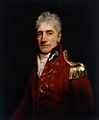
Lieutenant General Sir Iven Giffard Mackay, KBE, CMG, DSO & Bar, VD (7 April 1882 – 30 September 1966) was a senior Australian Army officer who served in both world wars.
Mackay graduated from the University of Sydney in 1904 and taught physics there from 1910 until 1914, when he joined the Australian Imperial Force shortly after the outbreak of the First World War. He served with the 4th Infantry Battalion at Gallipoli, where he distinguished himself in hand-to-hand fighting at the Battle of Lone Pine. In April 1916, he assumed command of the 4th Infantry Battalion on the Western Front and led it at the Battle of Pozières, Battle of Bullecourt and Battle of Broodseinde. He was promoted to brigadier general in June 1918, and led the 1st Infantry Brigade at the Battle of Hazebrouck, the Battle of Amiens and in the attack on the Hindenburg Line. (Full article...) -
Snowy Mountains Highway is a 333-kilometre-long (207 mi) state highway located in New South Wales, Australia. Its two sections connect the New South Wales South Coast to the Monaro region, and the Monaro to the South West Slopes via the Snowy Mountains. The higher altitude regions of this road are subject to snow over the winter months, and the road also provides access to many parts of the Snowy Mountains Scheme. The highway bears the B72 shield along its entire length.
The highway originally bore the name Monaro Highway until 1958, when it received its current name. It originally ran from Tathra to Wagga Wagga but has been shortened to run from Princes Highway to Hume Highway instead. Part of the roadway was reallocated to what is now known as Monaro Highway in 1955. Reservoirs created as a result of dams built in the 1950s and 1960s as part of the Snowy Mountains Scheme required the creation of major realignments to avoid submerged areas. Previous to New South Wales' conversion to alphanumeric route markers, it was signed as National Route 18. (Full article...)


.jpg)


Selected image

Chinese New Year is the most important of the traditional Chinese holidays. Depicted here is Chinese New Year in George Street, Sydney, in February 2006.
Related portals

(Northern
Territory) |
WikiProjects
Selected articles -
-
An outbreak of equine influenza (EI) in Australia was confirmed by the Department of Primary Industries (New South Wales) on 24 August 2007 in Sydney. Also known as "horse flu" and "A1 influenza", the rapid outbreak was of the Influenza A virus strain of subtype H3N8. While the virus is highly contagious, it rarely kills adult horses but the performance of thoroughbred racing horses can be affected for several weeks. It can be fatal to young foals and debilitated horses.
Because of strict quarantine procedures to reduce the risk of exotic pests and diseases entering Australia, this was the first outbreak of equine influenza in Australia. Horses in Australia had not been exposed to the virus and, not being vaccinated, were fully susceptible. (Full article...) -
The University of Sydney (USYD) is a public research university in Sydney, Australia. Founded in 1850, it is the oldest university in both Australia and Oceania. One of Australia's six sandstone universities, it was one of the world's first universities to admit students solely on academic merit, and opened its doors to women on the same basis as men. The university comprises eight academic faculties and university schools, through which it offers bachelor, master and doctoral degrees.
Five Nobel and two Crafoord laureates have been affiliated with the university as graduates and faculty. The university has educated eight Australian prime ministers, including incumbent Anthony Albanese; two governors-general of Australia; 13 premiers of New South Wales; and 26 justices of the High Court of Australia, including five chief justices. The university has produced 110 Rhodes Scholars and 19 Gates Scholars. The University of Sydney is a member of the Group of Eight, CEMS, the Association of Pacific Rim Universities and the Association of Commonwealth Universities. (Full article...) -
Mungo National Park is a protected national park that is located in south-western New South Wales, in eastern Australia. The 110,967-hectare (274,210-acre) national park is situated approximately 875 kilometres (544 mi) west of Sydney in the Balranald Shire. Mungo National Park is the traditional meeting place of the Muthi Muthi, Nyiampaar and Barkinji Aboriginal Nations. People are no longer able to climb the sand dunes by themselves as stricter rules have been enforced, all visitors groups need to be accompanied by an accredited tour guide to access the sand dunes.
The national park is part of the UNESCO World Heritage–listed Willandra Lakes Region, an area of 2,400 square kilometres (930 sq mi) that incorporates seventeen dry lakes. The seventeen dry lakes are not all called Mungo but are all declared world heritage. The creek that used to flow into Mungo is being preserved as a sacred site. The national park is about 75 kilometres (47 mi) south-east of Pooncarie, 110 kilometres (68 mi) north-east of Mildura and approximately 145 kilometres (90 mi), 90 minutes drive south-west of Ivanhoe. The roads to, in or around the park are unsealed and can be accessed in 2-wheel-drive cars, but councils will close the road in wet weather. (Full article...) -

Pacific Highway is a 790-kilometre-long (491 mi) national highway and major transport route along the central east coast of Australia, with the majority of it being part of Australia's Highway 1. The highway and its adjoining Pacific Motorway between Brisbane and Brunswick Heads and Pacific Motorway between Sydney and Newcastle links the state capitals of Sydney in New South Wales with Brisbane in Queensland, approximately paralleling the Tasman Sea and the Coral Sea of the South Pacific Ocean coast, via regional cities and towns like Gosford (Central Coast NSW), Newcastle, Taree, Port Macquarie, Kempsey, Coffs Harbour, Grafton, Ballina, Byron Bay, Tweed Heads and the Gold Coast, which is part of Queensland. Additionally, between Brunswick Heads and Port Macquarie (excluding a short stretch around Coffs Harbour), the road is also signed as Pacific Motorway, but has not been legally gazetted as such.
Pacific Highway no longer includes former sections of the highway between Brunswick Heads and Brisbane that have been legally renamed. As such, the highway stops short of the Queensland border near the Gold Coast. It is one of the busiest highways in Australia and was reconstructed as a controlled-access highway (motorway) and limited-access road (dual carriageway) standards between Hexham and the Queensland border between 1996 and December 2020, excepting a portion of remnant surface road around Coffs Harbour, with major construction of the Coffs Harbour Bypass expected to commence in 2023. (Full article...) -
The Sydney central business district (CBD) is the historical and main commercial centre of Sydney. The CBD is Sydney's city centre, or Sydney City, and the two terms are used interchangeably. Colloquially, the CBD or city centre is often referred to simply as "Town" or "the City". The Sydney city centre extends southwards for about 3 km (2 mi) from Sydney Cove, the point of first European settlement in which the Sydney region was initially established.
Geographically, its north–south axis runs from Circular Quay in the north to Central railway station in the south. Its east–west axis runs from a chain of parkland that includes Hyde Park, The Domain, Royal Botanic Garden and Farm Cove on Sydney Harbour in the east; to Darling Harbour and the Western Distributor in the west. (Full article...) -

Cape Byron is the easternmost point of the mainland of Australia, located in New South Wales. It is about 3 km (1.9 mi) east of the town of Byron Bay, New South Wales and projects into the Pacific Ocean at 28.6335° S, 153.6383° E. A lighthouse is situated there. It is a popular area for hiking and for whale watching. Two national parks, one a conservation area and a marine park, are on the bay.
Cape Byron has a significant influences on the open beaches to its north. Longshore drift transports sand northwards. Sand blocked by the cape drops off the continental shelf, which is very narrow here, at a rate of around 50,000 cubic metres of sand per year. (Full article...) -

Invicta, the flag of the English county of Kent
Tooth and Co was the major brewer of beer in New South Wales, Australia. The company owned a large brewery on Broadway in Sydney from 1835 to 1985, known as the Kent Brewery. It was historically one of Australia's oldest companies, having been established as a partnership in 1835. The brand was revived in 2015. (Full article...) -

Football Australia is the governing body of soccer, futsal, and beach soccer within Australia, headquartered in Sydney. Although the first governing body of the sport was founded in 1911, Football Australia in its current form was only established in 1961 as the Australian Soccer Federation. It was later reconstituted in 2003 as the Australian Soccer Association before adopting the name of Football Federation Australia in 2005. In contemporary identification, a corporate decision was undertaken to institute that name to deliver a "more united football" in a deliberation from the current CEO, James Johnson. The name was changed to Football Australia in December 2020.
Football Australia oversees the men's, women's, youth, Paralympic, beach and futsal national teams in Australia, the national coaching programs and the state governing bodies for the sport. It sanctions professional, semi-professional and amateur soccer in Australia. Football Australia made the decision to leave the Oceania Football Confederation (OFC), for which it was a founding member, and become a member of the Asian Football Confederation (AFC) on 1 January 2006 and ASEAN Football Federation (AFF) on 27 August 2013. (Full article...) -
The Sydney Symphony Orchestra (SSO) is an Australian symphony orchestra based in Sydney. Initially formed in 1908, the orchestra has performed at the Sydney Opera House as its home concert hall, since the venue's opening in 1973. Simone Young is the orchestra's chief conductor and the first female conductor in the post. (Full article...) -
Geologically the Australian state of New South Wales consists of seven main regions: Lachlan Fold Belt, the Hunter-Bowen Orogeny or New England Orogen (NEO), the Delamerian Orogeny, the Clarence Moreton Basin, the Great Artesian Basin, the Sydney Basin, and the Murray Basin.
There are a few other sedimentary basins, the Great Artesian Basin can be broken into the Eromanga Basin in the west and the Surat Basin to the east. The Sydney Basin extends north into the Gunnedah Basin, which goes even further north into the Bowen Basin which extends into Queensland, under the Surat Basin. The New England Orogen has a few small Basins included, such as the Lorne Basin, the Myall Syncline, and Gloucester Basin. The Oaklands Basin is in the south of the state under the Murray Basin. The Darling Basin is in the state's west, but mostly covered by the Murray Basin. Gilgandra Sub-Basin and Paka Tank Trough are potential places for coal and gas. (Full article...) -
The history of New South Wales refers to the history of the Australian state of New South Wales and the area's preceding Indigenous and British colonial societies. The Mungo Lake remains indicate occupation of parts of the New South Wales area by Indigenous Australians for at least 40,000 years. The British navigator James Cook became the first European to map the coast in 1770 and a First Fleet of British convicts followed to establish a penal colony at Sydney in 1788.
The colony established an autonomous parliamentary democracy from the 1850s and became a state of the Commonwealth of Australia in 1901 following a vote to federate with the other British colonies of Australia. Through the 20th century, the state was a major destination for an increasingly diverse collection of migrants from many nations. In the 21st century, the state is the most populous in Australia, and its capital, Sydney is a major financial capital and host to international cultural and economic events. (Full article...) -

Sydney Cove, Circular Quay
Sydney Cove (Eora: Warrane) is a bay on the southern shore of Sydney Harbour, one of several harbours in Port Jackson, on the coast of Sydney, New South Wales. Sydney Cove is a focal point for community celebrations, due to its central Sydney location between the Sydney Opera House and the Sydney Harbour Bridge.
Sydney Cove was the site of the First Fleet's landing on 26 January 1788 and the subsequent raising of the Union Jack, a seminal date in Australian history now marked as Australia Day. (Full article...) -

The Big Golden Guitar is one of the many "big" attractions that can be found around Australia. Located in Tamworth, New South Wales, the monument is one of the best-known points of interest in New England.
It is also a major attraction during the Tamworth Country Music Festival. (Full article...) -
Northern Rivers is the most northeasterly region of the Australian state of New South Wales, located between 590 and 820 kilometres (370 and 510 mi) north of the state capital, Sydney, and encompasses the catchments and fertile valleys of the Clarence, Richmond, and Tweed rivers. It extends from Tweed Heads in the north (adjacent to the Queensland border) to the southern extent of the Clarence river catchment which lies between Grafton and Coffs Harbour, and includes the main towns of Tweed Heads, Byron Bay, Ballina, Kyogle, Lismore, Casino and Grafton. At its most northern point, the region is 102 kilometres (63 mi) south-southeast of the Queensland capital, Brisbane.
As with all regions of New South Wales, it has no official status, although state government department offices and local governments in the area work together for purposes such as tourism, education, water catchment management and waste management. This area has a mild, sub-tropical climate. Major industries are agriculture, fisheries, public services (particularly health) and tourism; the region is also popular for niche crops, hobby farmers, and retirees from life in the larger cities. (Full article...) -
The Kosciuszko National Park (/ˌkɒziˈʌskoʊ/) is a 6,900-square-kilometre (2,700 sq mi) national park and contains mainland Australia's highest peak, Mount Kosciuszko, for which it is named, and Cabramurra, the highest town in Australia. Its borders contain a mix of rugged mountains and wilderness, characterised by an alpine climate, which makes it popular with recreational skiers and bushwalkers.
The park is located in the southeastern corner of New South Wales, 354 km (220 mi) southwest of Sydney, and is contiguous with the Alpine National Park in Victoria to the south, and the Namadgi National Park in the Australian Capital Territory to the northeast. The larger towns of Cooma, Tumut and Jindabyne lie just outside and service the park. (Full article...)


Did you know (auto-generated)

- ... that Victorian post office official William Rundell also collected stamps in his spare time, acquiring 48 copies of the "Sydney view" stamps of New South Wales?
- ... that Turkish international soccer player Rojin Polat was named member of the "2021 All Schools Merit Girls Team" in New South Wales, Australia?
- ... that the "Cuddle with a Koala" experience at Featherdale Wildlife Park was stopped in 1988 when New South Wales law was changed to restrict koala handling?
General images -
-
 Dry paddocks in the Riverina region during the 2007 drought (from History of New South Wales)
 -
 Landing of Lieutenant James Cook at Botany Bay, 29 April 1770 (from History of New South Wales)
 -
 The 5th Governor of New South Wales, Lachlan Macquarie, was influential in establishing civil society in Australia (from History of New South Wales)
 -
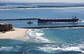 A bulk carrier entering the Port of Newcastle, New South Wales, 2009 (from Economy of New South Wales)
 -

-
 The Sydney Opera House was opened in 1973. (from History of New South Wales)
 -
 Aboriginal tribes in New South Wales, from an 1892 map (from History of New South Wales)
 -
 Mr E.H. Hargraves, The Gold Discoverer of Australia, returning the salute of the gold miners - Thomas Tyrwhitt Balcombe, 1851 (from History of New South Wales)
 -
 World leaders with Prime Minister John Howard in Sydney for the 2007 APEC conference (from History of New South Wales)
 -
 Olympic colours on the Sydney Harbour Bridge in the year 2000 (from History of New South Wales)
 -

-
 A 630 lb gold specimen from Hill End, unearthed in 1872 (from History of New South Wales)
 -
 William Wentworth was key in the establishment of self-governance in New South Wales (from History of New South Wales)
 -
 Murray Grey cows and calves (from Economy of New South Wales)
 -
 Founding of the settlement of Port Jackson at Botany Bay in New South Wales in 1788 - Thomas Gosse (from History of New South Wales)
 -
 Early expeditions of Charles Sturt (from History of New South Wales)
 -
 Hyde Park, Sydney with the Australian Museum under construction in the distance, 1842 (from History of New South Wales)
 -
 Ribbon ceremony to open the Sydney Harbour Bridge on 20 March 1932. Breaking protocol, the soon to be dismissed Premier Jack Lang cuts the ribbon while Governor Philip Game looks on. (from History of New South Wales)
 -

-
 A General Chart of New Holland including New South Wales & Botany Bay with The Adjacent Countries and New Discovered Lands, published in An Historical Narrative of the Discovery of New Holland and New South Wales, London, Fielding and Stockdale, November 1786 (from History of New South Wales)
 -
 A chart of part of the interior of New South Wales by John Oxley, Surveyor General, 1822 (from History of New South Wales)
 -
 Tumut 3 Power Station was constructed as part of the vast Snowy Mountains Scheme in New South Wales (1949–1974). Construction necessitated the expansion of Australia's immigration program. (from History of New South Wales)
 -
 Humanitarian Caroline Chisholm provided support to poverty-stricken women migrants (from History of New South Wales)
 -
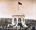 Federation Pavilion, Centennial Park, Sydney, 1 January 1901. (from History of New South Wales)
 -
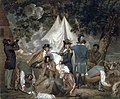
 Governor Arthur Phillip hoists the British flag over the new colony at Sydney in 1788 (from History of New South Wales)
 -
 Bondi Beach circa 1900 (from History of New South Wales)
 -
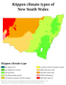 Köppen climate types in New South Wales (from Geography of New South Wales)
.jpg)
.jpg)


.jpg)


Topics
Categories

More portals
In the news
No recent news
Associated Wikimedia
The following Wikimedia Foundation sister projects provide more on this subject:
-
 Commons
Free media repository -
 Wikibooks
Free textbooks and manuals -
 Wikidata
Free knowledge base -
 Wikinews
Free-content news -
 Wikiquote
Collection of quotations -
 Wikisource
Free-content library -
 Wikiversity
Free learning tools -
 Wikivoyage
Free travel guide -
 Wiktionary
Dictionary and thesaurus


