Deschambault-Grondines was created in 2002 by the merger of the villages of Deschambault and Grondines. It is a member of the Fédération des Villages-relais du Québec. [1]' [2]
The village of Deschambault is located in the eastern part of the municipality. It has its origins in the Seigneurie de Chavigny, granted in 1640 by the Compagnie de la Nouvelle-France. In 1671, Jacques-Alexis Fleury, Sieur Deschambault, married the heiress of the seigneury and became its owner in 1683 through an exchange of land. He then gave his name to his new domain. The parish of Saint-Joseph-de-Deschambault was founded in 1713 and canonically erected in 1753. The parish municipality was created in 1855, and the village municipality separated from it in 1951. These two entities merged again in 1989.[3]' [4]
. . . At one time, Deschambault was said to have "a pilot every two houses." Very early on "the taste for the sea" developed there, because the St. Lawrence has long been the only way to access the village. "Everything was happening on the river !" says Father Jacques Paquin, coordinator of the Deschambault Navigators Committee."
Even after the opening of the Chemin du Roy, a route considered difficult, the seaway continued to be used more than the land route. Deschambault, a village of sailors, Le Soleil. Translated from French.[5]
Deschambault Built Heritage
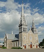
Saint-Joseph church built between 1835 and 1839 according to the plans of the architect Thomas Baillairgé[6]
Old presbytery built between 1815 and 1818.
Water mill built in 1802 by Seigneur Joseph Chavigny de la Chevrotière.
The estate covered a land area of around 90 square miles or nearly 60,000 acres.[8]' [9] In 1646, the Governor of New-France at the time, Charles Jacques Huault de Montmagny,[10] gave the concession to the nuns hospitallers, administrators of Hôtel-Dieu de Québec, and thereafter, it was resold in 1683 to Lord Jacques Aubert.[8] Being the father-in-law of Louis Hamelin, the next lord of Grondines, the lordship passed to the Hamelin family afterwards, and was transmitted to their descendants until 1797, following the British Conquest.[8] In 1698, comte Louis de Buade of Château Frontenac award them concessions, extending their lordship with additional islands and isles.[11] This family was one of the eight seigneurial dynasties that lived permanently on their estate for six generations.[12]
A member of this family was also recognized as noble by the Sovereign Council of New France of Louis XIV in 1654, and would join the French-Canadian nobility, being the lord and commander Jacques-François Hamelin de Bourgchemin et de l'Hermitière, a descendant of Jacques Hamelin, bishop of Tulle.[17][18][19]'[20] In 1766, a member of the Hamelin de Chavigny also appeared in documents of the Canadian nobility, where they asked the king to keep in power the current Governor of Quebec James Murray, with the hope of being less penalized by the injustices they had to suffer after the British conquest.[21]
Opposite Cape Lauzon, in the middle of the St. Lawrence River, the Richelieu Rapids stretch for a distance of nearly 2 km. These rapids, which are virtually invisible, correspond to a narrowing of the channel, marked, especially at low tide, by a much stronger current than anywhere else on the St. Lawrence downstream of Montreal.[25]' [26]
From the canoes of the First Nations to the ships of the conquerors, the Richelieu Rapids have played a strategic role in the history of Cape Lauzon, Deschambault and all of Quebec. To this day, they still make life as hard for sailboats, rowboats, canoes, small boats as they do for the captains of large merchant ships.[27]
The St. Lawrence River limits the territory of Portneuf regional County (RCM) for nearly 70 km. Along the Chemin du Roi, from one village to another, several spaces allow you to rest, visit, picnic, fish, observe birds, dip your toes in the water. The main attraction remains the docks.[28]
In Grondines, the tip of the Anse des Grondines, also known in the vernacular: La Grande Pointe, Pointe de la Laille or Grande pointe de la Laille. The word laille could come from the English light, since there was a lighthouse at the end of the island.
According to historian Raymond Douville, this point is the origin of the name Grondines, probably given by the boaters who had to go around, at the rising tide, the many pebbles that the waves hit in dull roars and whose echoes resonated on the escarpments of the coast.[23]
Fossil found along the St. Lawrence River, Grondines
DESCRIPTION OF THE AREA
« . . . The part of the Grondines map-area underlain by Paleozoic rocks (approximately two-thirds of the whole) is a nearly featureless plain rising in the north and west to 250 feet above sea level, and dropping to tide water level along the Saint-Laurent. »
« . . . The Grondines and Sainte-Anne-de-la-Pérade swamp is one of the last, large, treed swamps on the river. It extends along seven kilometres of shoreline in the St. Lawrence River’s freshwater estuary.
The swamp shelters several at-risk species, including plants that are endemic to the freshwater estuary. It is a rare biodiversity hot spot on a global scale, according to the Atlas de la biodiversité du Québec (Quebec biodiversity atlas). »
The Grondines and Sainte-Anne-de-la-Pérade Swamp, A unique ecosystem.[31]
^ ab"Deschambault-Grondines". Commission de toponymie Quebec (in French). Government of Quebec. 12 April 2002. Retrieved 13 February 2024. The municipality of Deschambault-Grondines was created on February 27, 2002. It is the result of the merger of the municipalities of Deschambault and Grondines
^Yves Roby, Francine Roy (2 May 2013). "Deschambault"(PDF) (in French). pp. 18 of 23. Retrieved 10 February 2024. Must hold fire and place over their seigneury, grant land to anyone who requests it, build and maintain a common mill, and establish a seigneurial court for the administration of low and middle justice
^René Baudry, c.s.c. (2 September 1957). "Charles d'Aulnay and the Compagnie de la Nouvelle-France"(PDF) (in French). Revue d'histoire de l'Amérique française. p. 25. Retrieved 9 February 2024. But it is very difficult to write definitive history. Like all art and all living science, history refuses to be fossilized.
^Johanne Martin (2 August 2020). "Deschambault, a village of sailors" (in French). Retrieved 15 February 2024. For 250 years, this corner of paradise located on the banks of the river has seen the birth of more than 1000 sailors... And the maritime tradition is still very much alive today
^ abCulture and Communications Quebec. "Église de Saint-Joseph" (in French). Deschambault-Grondines: Répertoire du patrimoine culturel du Québec. Retrieved 13 February 2024. The Church of Saint-Joseph, erected on a promontory overlooking the St. Lawrence River called Cap Lauzon, stands at the heart of a Catholic religious complex that also includes two former presbyteries, the cemetery, the former inhabitants' hall and the former convent, surrounded by vast green spaces planted with trees.
^"Seigneury of Grondines and the parish of Saint-Charles-des-Grondines" (in French). Municipality of Saint-Casimir. 2024. p. History. Retrieved 15 February 2024. The territory of Saint-Casimir was originally part of the seigneury of Grondines and the parish of Saint-Charles-des-Grondines.
^"Seigneuries of Grondines and Deschambault" (in French). Deschambault-Grondines. p. History. Retrieved 15 February 2024. The seigneuries of Grondines and Deschambault were granted at the same time by the Compagnie de la Nouvelle-France known as the Compagnie des Cent-Associés.
^ abAbbé A. Couillard Després (1916). "The nobility of France and Canada" (in French). Collection laurentienne. pp. 49 of 75. Retrieved 16 February 2024. The English of Quebec won their case at the court of London; the Canadians were removed from public office, and the nobility who might have rendered good service were regarded as suspect.
^ abT. H. Clark, Y Globensky (1975). "Grondines Area"(PDF) (in English and French). Ministère de l'Énergie et des Ressources naturelles - Gouvernement du Québec. p. 172. Retrieved 14 February 2024. The Saint-Laurent river is here subject to tides. During the summer months the expectable difference between high and low levels ranges from 11 to 15 feet
^ ab"Pointe des Grondines". Commission de toponymie Quebec. Government of Quebec. 5 December 1968. Retrieved 14 February 2024. This point is said to be the origin of the name Grondines, probably given by the boaters who had to go around, at the rising tide, the numerous pebbles that the waves hit in rumblings
^The Ages of Exploration. "Jacques Cartier". The Mariners' Museum and ParK. Retrieved 13 January 2024. Jacques Cartier is credited with discovering and claiming the land now known as Canada for France.
^ ab"Cape Lauzon". Commission de toponymie Quebec (in French). Government of Quebec. 5 December 1968. Retrieved 13 February 2024. This cape, in the shape of a semicircle and nearly 25 m high, extends 500 m from northwest to southeast into the St. Lawrence.
^"Richelieu Rapids". Commission de toponymie Quebec (in French). Government of Quebec. 5 December 1968. Retrieved 13 February 2024. An important landmark for sailors, the Richelieu Rapids are located in the middle of the St. Lawrence, 1.5 km from the coast, between Lotbinière and Deschambault.
^"St. Lawrence River, Cap-Rouge to Montréal and Rivière Richelieu"(PDF). Canadian Hydrographic Servie. 2022. p. 92. Retrieved 13 February 2024. This publication are requested to forward information regarding newly discovered dangers, changes in aids to navigation, the existence of new shoals or channels, or other information
^ abStéphanie Poirier (16 May 2021). "Public access to the St. Lawrence River in Portneuf" (in French). Tourisme Portneuf. Retrieved 13 February 2024. The Portneuvois coastline is Deschambault-Grondines, Portneuf, Cap-Santé, Donnacona and Neuville.
^"Cardinal cove". Commission de toponymie Quebec. Government of Quebec. 9 March 1988. Retrieved 14 February 2024. St Lawrence Cove - Anse Le Cardinal
^T. H.Clark; Y.Globensky (1975). "Grondines Area"(PDF). Ministère de l'Énergie et des Ressources naturelles - Gouvernement du Québec. pp. 127 of 172. Retrieved 16 February 2024. Fossils of the Grondines members
^"The Grondines and Sainte-Anne-de-la-Pérade Swamp". Nature Conservancy Canada. Retrieved 13 February 2024. The Grondines and Sainte-Anne-de-la-Pérade swamp is one of the last, large, treed swamps on the river. It extends along seven kilometres of shoreline in the St. Lawrence River's freshwater estuary.
^"Deschambault-Grondines Climate". Canadian Climate Normals 1981–2010 (in English and French). Environment Canada. 31 October 2011. Retrieved 16 July 2015.
Mariages de Deschambault (comté Portneuf) – 1713–1900, raised by Rosaire Proulx priest, compiled and published by Benoit Pontbriand agronomist, 1966, 213 pages (in French)


![Saint-Joseph church built between 1835 and 1839 according to the plans of the architect Thomas Baillairgé[6]](//upload.wikimedia.org/wikipedia/commons/thumb/3/3c/Deschambault_church_2.jpg/240px-Deschambault_church_2.jpg) Saint-Joseph church built between 1835 and 1839 according to the plans of the architect Thomas Baillairgé[6]
Saint-Joseph church built between 1835 and 1839 according to the plans of the architect Thomas Baillairgé[6]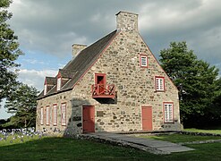 Old presbytery built between 1815 and 1818.
 Water mill built in 1802 by Seigneur Joseph Chavigny de la Chevrotière.
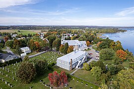 Deschambault on St Lawrence north shore
![Saint-Joseph church built between 1835 and 1839 according to the plans of the architect Thomas Baillairgé[6]](/wiki/File:Deschambault_church_2.jpg)


.jpg)
 Saint-Charles-Borromée church built between 1839 and 1842 according to the plans of architect Thomas Baillairgé.
 Presbytery of Saint-Charles-des-Grondines, chemin du Roy
 Saint-Charles-Borromée Parish Cemetery, Sir Lomer-Gouin Road
 Information board, in front of the cemetery, Sir-Lomer-Gouin Road
 Commemorative plaque on the façade of the church


 La Chevrotière River, La Chevrotière Watermill, rue de Chavigny
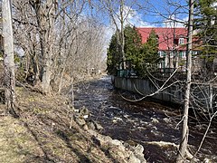 Rivière du Moulin, private property, Vieux moulin Hamelin, chemin Sir-Lomer-Gouin
 On the vintage truck: Paul Guilbault, Grondines, Charroyage général (Transport), chemin Sir-Lomer-Gouin


![Sign, Cap Lauzon,[25] a strategic location, rue de l'Église](//upload.wikimedia.org/wikipedia/commons/thumb/0/0b/Cap_Lauzon_018.jpg/270px-Cap_Lauzon_018.jpg) Sign, Cap Lauzon,[25] a strategic location, rue de l'Église
Sign, Cap Lauzon,[25] a strategic location, rue de l'Église Wharf of Deschambault, from Cap Lauzon, rue Saint-Joseph
 From Cap Lauzon, rue Saint-Joseph
 From Cap Lauzon, rue Saint-Joseph
![Sign, Cap Lauzon,[25] a strategic location, rue de l'Église](/wiki/File:Cap_Lauzon_018.jpg)


 Tidal flats, Ardea herodias. Great blue heron. Great Blue Heron and Killdeer Plover, chemin des Ancêtres
 Ordinary mill or windmill, tidal flats at low tide, from the wharf
![Private Property, Duck Cache Launch[22]](//upload.wikimedia.org/wikipedia/commons/thumb/2/2f/Anse_a_Caron_050.jpg/270px-Anse_a_Caron_050.jpg) Private Property, Duck Cache Launch[22]
Private Property, Duck Cache Launch[22]![Private Property, Canal déferrant du Cardinal (Cove),[29] the landfill, back beach](//upload.wikimedia.org/wikipedia/commons/thumb/8/87/Domaine_Trottier_005.jpg/270px-Domaine_Trottier_005.jpg) Private Property, Canal déferrant du Cardinal (Cove),[29] the landfill, back beach
Private Property, Canal déferrant du Cardinal (Cove),[29] the landfill, back beach Snow, ice and light fog, chemin des Ancêtres
![Wharf, breakwater, boat launch, harbour[28]](//upload.wikimedia.org/wikipedia/commons/thumb/a/a0/2020_08_14_046_quai_Grondines.jpg/240px-2020_08_14_046_quai_Grondines.jpg) Wharf, breakwater, boat launch, harbour[28]
Wharf, breakwater, boat launch, harbour[28] Private property, clothesline & Swing, Sir-Lomer-Gouin Road

![Private Property, Duck Cache Launch[22]](/wiki/File:Anse_a_Caron_050.jpg)
![Private Property, Canal déferrant du Cardinal (Cove),[29] the landfill, back beach](/wiki/File:Domaine_Trottier_005.jpg)

![Wharf, breakwater, boat launch, harbour[28]](/wiki/File:2020_08_14_046_quai_Grondines.jpg)


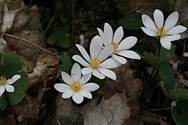 Sanguinaria canadensis L. — Bloodroot
 Physocarpus opulifolius (L.) Maxim. — Nine-bark
 Hesperis matronalis L. — Dame's rocket
 Malva moschata L. — Musk mallow
 Centaurea nigra L. ― Black knapweed
 Impatiens glandulifera Royle. ― Giant Impatiens


