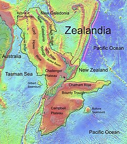
Joseph Gilbert Seamount is a large seamount in the Tasman Sea located 450 km (280 mi) west of the South Island of New Zealand at the southern edge of the Lord Howe Rise.[1][2] It has an elongated northwest–southeast trend, covering an area of about 11,500 km2 (4,400 sq mi) and rising to 2,400 m (7,900 ft) below sea level.[2]
| Joseph Gilbert Seamount | |
|---|---|
 Topographic map of Zealandia, showing Gilbert Seamount | |
| Summit depth | 2,400 m (7,900 ft) |
| Location | |
| Location | Tasman Sea |
| Coordinates | 42°52′18.1″S 164°4′0.1″E / 42.871694°S 164.066694°E |
| Country | New Zealand |
| Geology | |
| Type | Seamount (continental fragment) |
The seamount is a continental fragment that rifted away from the South Tasman Rise and Challenger Plateau during the Cretaceous breakup of Gondwana.[2][3] It is separated from the easterly Challenger Plateau by a 4,400 m (14,400 ft) deep saddle.[2]
Joseph Gilbert Seamount is named after Joseph Gilbert, captain of HMS Resolution (1771) on the second voyage of James Cook,[1] and has been known under a variety of names throughout its history, including Gilbert Ridge, Gilbert Seamount Complex and Gilbert Seamount.[1]
References
edit- ^ a b c "Marine Gazetteer Placedetails". Retrieved 15 March 2020.
- ^ a b c d Wood, R. (2002). "Finding the continental shelf – integration of geology and geophysics" (PDF). GNS Science. pp. 3, 4. Retrieved 15 March 2020.
- ^ Gaina, C.; Müller, R. D.; Brown, B.; Ishihara, T. (2001). "Microcontinent formation around Australia" (PDF). Geological Society of Australia. p. 399. Archived from the original (PDF) on 23 July 2008.