Size of this preview: 800 × 548 pixels. Other resolutions: 320 × 219 pixels | 640 × 438 pixels | 980 × 671 pixels.
Original file (980 × 671 pixels, file size: 262 KB, MIME type: image/png)
| This is a file from the Wikimedia Commons. Information from its description page there is shown below. Commons is a freely licensed media file repository. You can help. |
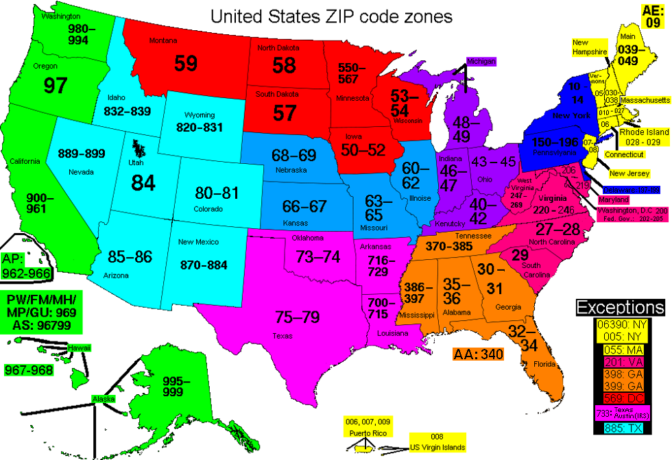
| Description | This map of the United States divides the country into ZIP code zones. All states with a common color use ZIP codes starting with the same digit. Each string of digits, whether two or three digits in length, refers to an allocation which reflects all existing ZIP codes starting with those two or three digits. | ||
| Date | |||
| Source | Own work, based on Image:ZIP_Code_zones.svg | ||
| Author | Jrooksjr | ||
| Permission (Reusing this file) |
|
||
| Other versions | Image:ZIP_Code_zones.svg |
File history
Click on a date/time to view the file as it appeared at that time.
| Date/Time | Thumbnail | Dimensions | User | Comment | |
|---|---|---|---|---|---|
| current | 21:28, 29 December 2017 | | 980 × 671 (262 KB) | Jrooksjr | Removed the 'Outside US: 001' tag as there is no 001 per the USPS L005 3-digit ZIP Code prefix Groups<br/> Corrected 'Delawares' text color coding from yellow to blue to match the zone color that it belongs to |
| 22:39, 8 December 2017 |  | 980 × 671 (281 KB) | Jrooksjr |
File usage
No pages on the English Wikipedia use this file (pages on other projects are not listed).