No higher resolution available.
Winter_Trans-Alaska_Pipeline-CRREL.jpg (280 × 138 pixels, file size: 74 KB, MIME type: image/jpeg)
| This is a file from the Wikimedia Commons. Information from its description page there is shown below. Commons is a freely licensed media file repository. You can help. |
Summary
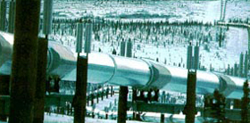
| Description |
English: View of the Trans-Alaska Pipeline between Fort Greeley, Alaska and Black Rapids, a region with discontinuous permafrost. The pipeline is suspended on thermosyphon piles that transport coolant via natural convection into the ground during winter to maintain frozen soil around the piling. In the summer, the convection of the coolant fluid stops. |
| Date | |
| Source | U.S. Army Cold Regions Research and Engineering Laboratory: http://www.crrel.usace.army.mil/crrel/selectedimages.html |
| Author | Stephen Flanders |
Licensing
This file is a work of a U.S. Army soldier or employee, taken or made as part of that person's official duties. As a work of the U.S. federal government, it is in the public domain in the United States.
|
 |
File history
Click on a date/time to view the file as it appeared at that time.
| Date/Time | Thumbnail | Dimensions | User | Comment | |
|---|---|---|---|---|---|
| current | 15:33, 6 January 2011 | | 280 × 138 (74 KB) | HopsonRoad | {{Information |Description={{en|1=View of the Trans-Alaska Pipeline between Fort Greeley, Alaska and Black Rapids.}} |Source=U.S. Army Cold Regions Research and Engineering Laboratory |Author=Stephen Flanders |Date=1982-03-00 |Permission= |other_versions= |
File usage
The following pages on the English Wikipedia use this file (pages on other projects are not listed):