
Size of this preview: 800 × 535 pixels. Other resolutions: 320 × 214 pixels | 640 × 428 pixels | 1,024 × 685 pixels | 1,280 × 856 pixels | 2,560 × 1,711 pixels | 3,131 × 2,093 pixels.
Original file (3,131 × 2,093 pixels, file size: 3.06 MB, MIME type: image/jpeg)
| This is a file from the Wikimedia Commons. Information from its description page there is shown below. Commons is a freely licensed media file repository. You can help. |
Summary
| Description |
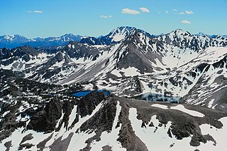
English: At center, Castle Peak. Photo taken from a ridge on the south flank of Calkens Peak. I never made it to the top. I had promised my friends I would be back by a certain time and I was going to be late. Could've made it perhaps - I was probably 1,200 feet (370 m) shy of the summit but alone. Scanned slide. |
| Date | |
| Source |
White Cloud Peaks, Sawtooth National Recreation Area ID
|
| Author | Roy Luck |
| Camera location | | View this and other nearby images on: OpenStreetMap |
|---|
Licensing
This file is licensed under the Creative Commons Attribution 2.0 Generic license.
- You are free:
- to share – to copy, distribute and transmit the work
- to remix – to adapt the work
- Under the following conditions:
- attribution – You must give appropriate credit, provide a link to the license, and indicate if changes were made. You may do so in any reasonable manner, but not in any way that suggests the licensor endorses you or your use.
| This image, originally posted to Flickr, was reviewed on 10 October 2012 by the administrator or reviewer File Upload Bot (Magnus Manske), who confirmed that it was available on Flickr under the stated license on that date. |
File history
Click on a date/time to view the file as it appeared at that time.
| Date/Time | Thumbnail | Dimensions | User | Comment | |
|---|---|---|---|---|---|
| current | 01:05, 10 October 2012 | | 3,131 × 2,093 (3.06 MB) | File Upload Bot (Magnus Manske) | Transferred from Flickr by User:Fredlyfish4 using flickr2commons |
File usage
The following pages on the English Wikipedia use this file (pages on other projects are not listed):