
Size of this preview: 600 × 600 pixels. Other resolutions: 240 × 240 pixels | 480 × 480 pixels | 768 × 768 pixels | 1,024 × 1,024 pixels.
Original file (1,024 × 1,024 pixels, file size: 1.21 MB, MIME type: image/png)
| This is a file from the Wikimedia Commons. Information from its description page there is shown below. Commons is a freely licensed media file repository. You can help. |
Summary
| Description |
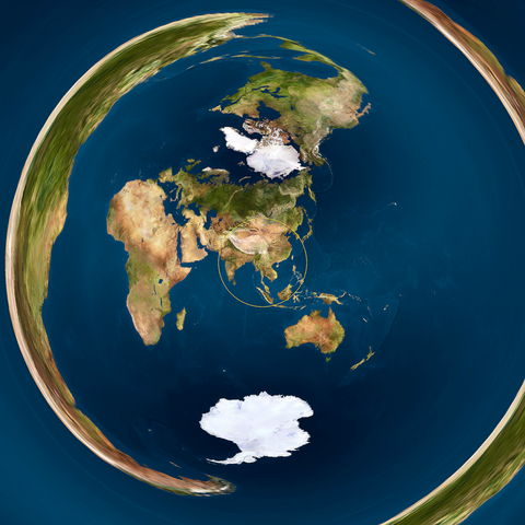
English: Danny Quah's Valerispieris circle on a globe model, centred on Mong Khet, Myanmar, rendered in azimuthal equidistant projection from the equirectangular projection from http://commons.wikimedia.org/wiki/File:Earthmap1000x500.jpg by CMG Lee. |
|||
| Date | upload 25. Oct. 2005 | |||
| Source |
|
|||
| Author | cmglee, jimht at shaw dot ca | |||
| Other versions |
|


Python source
#!/usr/bin/env python

import re, math, png

path_in          = 'mya/Earthmap1000x500.png'
path_out         = 'Valeriepieris_circle_azimuthal_equidistant.png'
colour_circle    = [255, 255, 0]
radius_circle    = 0.51
thickness_circle = 0.01
lat_centre       = 21.7
long_centre      = 99.383333
zoom             = 0.33
out_size         = 2048
out_size_half    = out_size * 0.5

class Png:
 def __init__(self, path_in):
  (self.width, self.height, self.pixels, self.metadata) = png.Reader(path_in).read_flat()
  self.planes = self.metadata['planes']
 def __str__(self): return str((self.width, self.height, len(self.pixels), self.metadata))
 def write(self, path_out):
  png.Writer(width=self.width, height=self.height,
             bitdepth=self.metadata['bitdepth'], interlace=self.metadata['interlace'],
             planes=self.metadata['planes'], greyscale=self.metadata['greyscale'],
             alpha=self.metadata['alpha']).write_array(open(path_out, 'wb'), self.pixels)

## Formulas from http://mathworld.wolfram.com/AzimuthalEquidistantProjection.html
def azimuthal_equidistant_to_equirectangular(x, y, lat1, long1):
 c        = math.hypot(x, y)
 if c == 0 or (abs(lat1) == 90 and y == 0): return (0, 0)
 sin_c    = math.sin(c)
 cos_c    = math.cos(c)
 lat1_rad = math.radians(lat1)
 sin_lat1 = math.sin(lat1_rad)
 cos_lat1 = math.cos(lat1_rad)
 to_asin  = cos_c * sin_lat1 + y * sin_c * cos_lat1 / c
 if abs(to_asin) > 1: return (0, 0)
 lat  =  math.degrees(math.asin(to_asin))
 long = (math.degrees(math.atan2(-x, y) if lat1 ==  90 else
                      math.atan2( x, y) if lat1 == -90 else
                      math.atan2(x * sin_c, c * cos_lat1 * cos_c - y * sin_lat1 * sin_c)) +
         long1 + 540) % 360 - 180 ## + 540 % 360 - 180 to make range [-180, 180)
 return (lat, long)

png_in  = Png(path_in)
print(png_in)
print(png_in.pixels[:20])
png_out = Png(path_in) ## copy most of original's metadata
png_out.width  = png_out.height = out_size
png_out.pixels = [0] * (png_out.width * png_out.height)
print(png_out)
for  out_y in range(out_size):
 for out_x in range(out_size):
  x = (out_x / out_size_half - 1) /  zoom
  y = (out_y / out_size_half - 1) / -zoom
  if abs(math.hypot(x,y) - radius_circle) < thickness_circle * zoom:
   colour = colour_circle
  else:
   (lat, long) = azimuthal_equidistant_to_equirectangular(x, y, lat_centre, long_centre)
   in_y = int(png_in.height * ( 90 - lat ) / 180.0)
   in_x = int(png_in.width  * (180 + long) / 360.0)
   in_offset = (in_y  * png_in.width + in_x ) * png_in .planes
   colour = png_in.pixels[in_offset :in_offset  + png_in.planes]
  out_offset = (out_y * out_size     + out_x) * png_out.planes
  png_out.pixels[out_offset:out_offset + png_out.planes] = colour
png_out.write(path_out)
Licensing
This file is licensed under the Creative Commons Attribution-Share Alike 4.0 International license.
- You are free:
- to share – to copy, distribute and transmit the work
- to remix – to adapt the work
- Under the following conditions:
- attribution – You must give appropriate credit, provide a link to the license, and indicate if changes were made. You may do so in any reasonable manner, but not in any way that suggests the licensor endorses you or your use.
- share alike – If you remix, transform, or build upon the material, you must distribute your contributions under the same or compatible license as the original.
File history
Click on a date/time to view the file as it appeared at that time.
| Date/Time | Thumbnail | Dimensions | User | Comment | |
|---|---|---|---|---|---|
| current | 01:02, 23 February 2022 | | 1,024 × 1,024 (1.21 MB) | Cmglee | Fix render |
| 01:43, 22 January 2022 |  | 1,024 × 1,024 (95 KB) | Cmglee | Uploaded a work by cmglee, jimht at shaw dot ca from {{source thumb|earthmap1000x500.jpg}} with UploadWizard |
File usage
The following pages on the English Wikipedia use this file (pages on other projects are not listed):
Global file usage
The following other wikis use this file:
- Usage on eu.wikipedia.org