
Size of this preview: 800 × 533 pixels. Other resolutions: 320 × 213 pixels | 640 × 427 pixels | 1,024 × 683 pixels | 1,280 × 853 pixels | 3,000 × 2,000 pixels.
Original file (3,000 × 2,000 pixels, file size: 4.48 MB, MIME type: image/jpeg)
| This is a file from the Wikimedia Commons. Information from its description page there is shown below. Commons is a freely licensed media file repository. You can help. |
Summary
| Description |
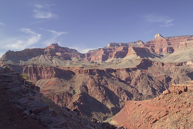
English: View of Utah Flats from the South Kaibab Trail. The Box section, at Granite Gorge, outfall of Bright Angel Creek, on Granite Gorge. (en:Isis Temple peak is center right; Shiva Temple, on horizon) (Intersection point of horizontal Tapeats with Shinumo Quartzite, resistant "island", in Tapeats Sea.) Also, en:Tapeats Sandstone horizontal unit, the en:caprock on the Granite Gorge (Inner Gorge) Vishnu Schist (or other member). The Tapeats Sandstone, erosion resistant unit, forms the Tonto Platform-(dendritic, Tree-shaped, following connected creeks, washes, canyons, etc.), overlying the 1-Vishnu Group (Vishnu Basement Rocks), and 2-Grand Canyon Supergroup Rocks. The Tonto Platform (Tapeats) allow the slope-forming, top Muav Limestone, and (greenish) Bright Angel Shale to accumulate. During climate timeperiods of extensive water erosion, the platform "regolith" would be removed, until a new erosion forming timeperiod. Deep in the Grand Canyon, usually removed from massive rain events, the accumulation of slope-forming deposits is quite extensive, and quite obvious to visual observation. The contact between the bottom of the Tapeats Sandstone and eroded upper surface of the units below, is the en:Great Unconformity, the erosion unconformity (a deposition unconformity) of about 1,000 million years (1.0 billion years). |
| Date | |
| Source | Own work |
| Author | Strother |
| Object location | | View this and other nearby images on: OpenStreetMap |
|---|
| Camera location | | View this and other nearby images on: OpenStreetMap |
|---|
Licensing
I, the copyright holder of this work, hereby publish it under the following license:
This file is licensed under the Creative Commons Attribution-Share Alike 3.0 Unported license.
- You are free:
- to share – to copy, distribute and transmit the work
- to remix – to adapt the work
- Under the following conditions:
- attribution – You must give appropriate credit, provide a link to the license, and indicate if changes were made. You may do so in any reasonable manner, but not in any way that suggests the licensor endorses you or your use.
- share alike – If you remix, transform, or build upon the material, you must distribute your contributions under the same or compatible license as the original.
| Annotations | This image is annotated: View the annotations at Commons |
File history
Click on a date/time to view the file as it appeared at that time.
| Date/Time | Thumbnail | Dimensions | User | Comment | |
|---|---|---|---|---|---|
| current | 14:07, 20 June 2010 | | 3,000 × 2,000 (4.48 MB) | Strother~commonswiki | {{Information |Description={{en|1=View of Utah Flats from the South Kaibab Trail.}} |Source={{own}} |Author=Strother |Date=2009-03-11 |Permission= |other_versions= }} Category:Grand Canyon |
File usage
The following pages on the English Wikipedia use this file (pages on other projects are not listed):
Global file usage
The following other wikis use this file:
- Usage on de.wikipedia.org