
Size of this preview: 800 × 600 pixels. Other resolutions: 320 × 240 pixels | 640 × 480 pixels | 1,024 × 768 pixels | 1,280 × 960 pixels | 1,911 × 1,433 pixels.
Original file (1,911 × 1,433 pixels, file size: 481 KB, MIME type: image/png)
| This is a file from the Wikimedia Commons. Information from its description page there is shown below. Commons is a freely licensed media file repository. You can help. |

|
This map image could be re-created using vector graphics as an SVG file. This has several advantages; see Commons:Media for cleanup for more information. If an SVG form of this image is available, please upload it and afterwards replace this template with
{{vector version available|new image name}}.
It is recommended to name the SVG file “Ukraine eparchies.svg”—then the template Vector version available (or Vva) does not need the new image name parameter. |
Summary
| Description |
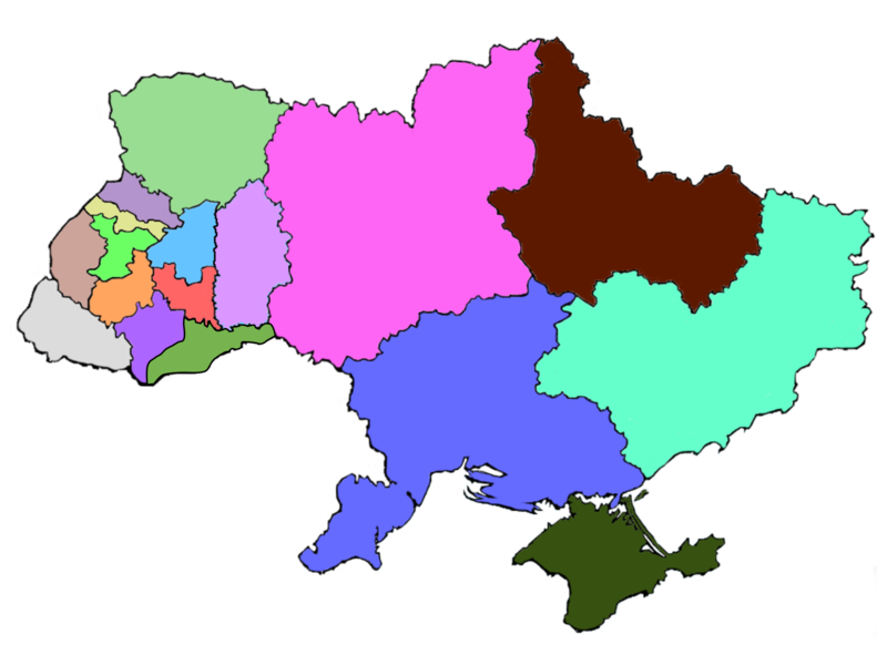
English: a fairly crude map of the territorial structure of the Ukrainian Greek Catholic Church within Ukraine.
Selfmade based on an empty contour map of Ukraine (Image:Map_of_Ukraine_political_simple_blank.png) and information from printed sources. 
|
| Date | 15 December 2007 (original upload date) |
| Source | Transferred from en.wikipedia to Commons by Avemundi using CommonsHelper. |
| Author | The original uploader was Vohon at English Wikipedia. |
Licensing

|
Permission is granted to copy, distribute and/or modify this document under the terms of the GNU Free Documentation License, Version 1.2 or any later version published by the Free Software Foundation; with no Invariant Sections, no Front-Cover Texts, and no Back-Cover Texts. A copy of the license is included in the section entitled GNU Free Documentation License. |
| This file is licensed under the Creative Commons Attribution-Share Alike 3.0 Unported license. | ||
| ||
| This licensing tag was added to this file as part of the GFDL licensing update. |
Original upload log
The original description page was here. All following user names refer to en.wikipedia.
- 2007-12-15 13:16 Vohon 800×600× (14822 bytes) {{PD-self}} a fairly crude map of the territorial structure of the [[Ukrainian Greek Catholic Church]] within [[Ukraine]]. Selfmade based on an empty contour map of Ukraine ([[:Image:Map of Ukraine political simple blank.png]]) and information from prin
File history
Click on a date/time to view the file as it appeared at that time.
| Date/Time | Thumbnail | Dimensions | User | Comment | |
|---|---|---|---|---|---|
| current | 01:46, 6 January 2019 | | 1,911 × 1,433 (481 KB) | Augustus-ua | Виділено Чернівецьку єпархію у 2017 р |
| 19:29, 20 March 2016 |  | 1,024 × 768 (152 KB) | Микола Василечко | Хмельницька область окремо | |
| 18:17, 8 January 2015 |  | 1,000 × 700 (149 KB) | Der Kaen | Added Exarchate of Kharkiv and Exarchate of Crimea. | |
| 19:59, 31 January 2009 |  | 800 × 600 (14 KB) | File Upload Bot (Magnus Manske) | {{BotMoveToCommons|en.wikipedia}} {{Information |Description={{en|a fairly crude map of the territorial structure of the en:Ukrainian Greek Catholic Church within en:Ukraine. Selfmade based on an empty contour map of Ukraine ([[:en::Image:Map |
File usage
The following pages on the English Wikipedia use this file (pages on other projects are not listed):
Global file usage
The following other wikis use this file:
- Usage on be.wikipedia.org
- Usage on bg.wikipedia.org
- Usage on cs.wikipedia.org
- Usage on de.wikipedia.org
- Usage on es.wikipedia.org
- Usage on fr.wikipedia.org
- Usage on hu.wikipedia.org
- Usage on id.wikipedia.org
- Usage on it.wikipedia.org
- Usage on pl.wikipedia.org
- Usage on pt.wikipedia.org
- Usage on ru.wikipedia.org
- Usage on sk.wikipedia.org
- Usage on sr.wikipedia.org
- Usage on uk.wikipedia.org
- Українська греко-католицька церква
- Чиказька єпархія святого Миколая УГКЦ
- Філадельфійська митрополія УГКЦ
- Івано-Франківська архієпархія УГКЦ
- Стемфордська єпархія УГКЦ
- Саскатунська єпархія УГКЦ
- Сокальсько-Жовківська єпархія УГКЦ
- Самбірсько-Дрогобицька єпархія УГКЦ
- Вроцлавсько-Кошалінська єпархія УГКЦ
- Користувач:Alex Blokha/Події в Вікіпедії/11 січня
- Коломийська єпархія УГКЦ
- Перемишльсько-Варшавська архієпархія УГКЦ
- Бучацька єпархія УГКЦ
- Вінніпезька митрополія УГКЦ
- Львівська архієпархія УГКЦ
- Шаблон:Територіальна структура УГКЦ
- Київська архієпархія УГКЦ
- Донецько-Харківський екзархат УГКЦ
- Луцький екзархат УГКЦ
- Стрийська єпархія УГКЦ
View more global usage of this file.