File:US Navy 110320-M-0145H-063 A large ferry boat rests inland amidst destroyed houses after a 9.0 earthquake and subsequent tsunami struck Japan March.jpg
Size of this preview: 800 × 533 pixels. Other resolutions: 320 × 213 pixels | 640 × 427 pixels | 1,023 × 682 pixels.
Original file (1,023 × 682 pixels, file size: 221 KB, MIME type: image/jpeg)
| This is a file from the Wikimedia Commons. Information from its description page there is shown below. Commons is a freely licensed media file repository. You can help. |
Summary
| Description |
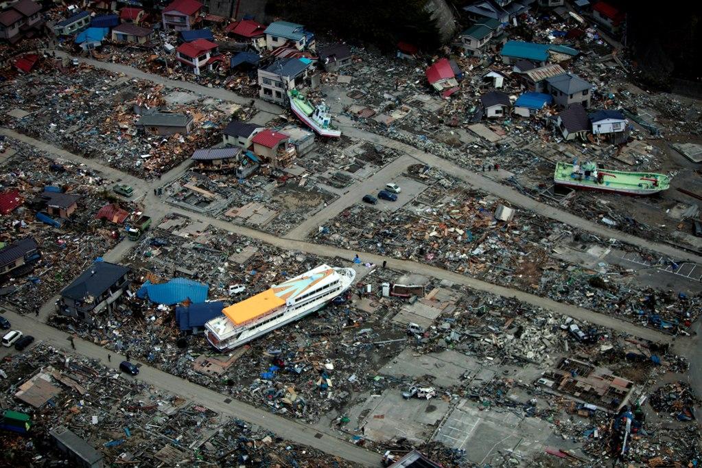
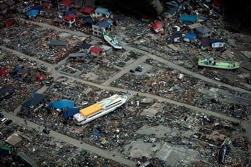
English: Miyako, Iwate Prefecture Japan (March 20, 2011). -- A large ferry boat rests inland amidst destroyed houses after a 9.0 earthquake and subsequent tsunami struck Japan March 11. As part of Operation Tomodachi, the 31st Marine Expeditionary Unit delivered much-needed relief supplies to the Japanese citizens in the area. (U.S. Marine Corps photo by Lance Cpl. Garry Welch/Released)
|
|||
| Date | Taken on 20 March 2011 | |||
| Source |
|
|||
| Author | U.S. Marine Corps photo by Lance Cpl. Garry Welch |

| Camera location | | View this and other nearby images on: OpenStreetMap |
|---|
Licensing
This file is a work of a sailor or employee of the U.S. Navy, taken or made as part of that person's official duties. As a work of the U.S. federal government, it is in the public domain in the United States.
|
 | |
| This file has been identified as being free of known restrictions under copyright law, including all related and neighboring rights. | ||
File history
Click on a date/time to view the file as it appeared at that time.
| Date/Time | Thumbnail | Dimensions | User | Comment | |
|---|---|---|---|---|---|
| current | 02:08, 30 March 2011 | | 1,023 × 682 (221 KB) | BotMultichillT | == {{int:filedesc}} == {{Information |description={{en|1=AICHI, Japan (March 20, 2011) A large ferry boat rests inland amidst destroyed houses after a 9.0 earthquake and subsequent tsunami struck Japan March 11. As part of Operation Tomodachi, the 31st Ma |
File usage
The following pages on the English Wikipedia use this file (pages on other projects are not listed):
Global file usage
The following other wikis use this file:
- Usage on de.wikipedia.org
- Usage on en.wikivoyage.org
- Usage on ja.wikipedia.org
- Usage on ja.wikinews.org
- Usage on ko.wikipedia.org
- Usage on ms.wikipedia.org
- Usage on pt.wikipedia.org
- Usage on sl.wikipedia.org
- Usage on sr.wikipedia.org
- Usage on sv.wikipedia.org
- Usage on ta.wikipedia.org