
Size of this preview: 800 × 533 pixels. Other resolutions: 320 × 213 pixels | 640 × 427 pixels | 1,024 × 683 pixels | 1,500 × 1,000 pixels.
Original file (1,500 × 1,000 pixels, file size: 527 KB, MIME type: image/jpeg)
| This is a file from the Wikimedia Commons. Information from its description page there is shown below. Commons is a freely licensed media file repository. You can help. |
| Description |
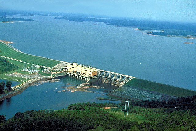
English: West Point Dam and Lake on the Chattahoochee River. The dam impounds West Point Lake. The dam is located near La Grange in Troup County, Georgia, USA, near the Alabama state line. The dam was constructed by the U.S. Army Corps of Engineers for flood control on the Chattahoochee River.
Coordinates: 32°55′5.51″N 85°11′16.53″W / 32.9181972°N 85.187925°W |
|||
| Location | Troup County, Georgia, USA | |||
| Date | (Caveat: Dates provided by U.S. Army Corps of Engineers Digital Visual Library are not reliable and are often wrong.) | |||
| Source |
U.S. Army Corps of Engineers Digital Visual Library Image page Image description page Digital Visual Library home page |
|||
| Author | Adrien Lamarre, U.S. Army Corps of Engineers | |||
| Permission (Reusing this file) |
|
File history
Click on a date/time to view the file as it appeared at that time.
| Date/Time | Thumbnail | Dimensions | User | Comment | |
|---|---|---|---|---|---|
| current | 01:48, 26 April 2007 | | 1,500 × 1,000 (527 KB) | DanMS | {{Information | Description = {{en|West Point Dam and Lake on the Chattahoochee River. The dam impounds West Point Lake. The dam is located near La Grange in Troup County, Georgia, USA, near the Alabama state line. The dam was constructed by the U.S. A |
File usage
The following pages on the English Wikipedia use this file (pages on other projects are not listed):
Global file usage
The following other wikis use this file:
- Usage on bg.wikipedia.org
- Usage on fr.wikipedia.org
- Usage on hu.wikipedia.org
- Usage on pl.wikipedia.org
- Usage on www.wikidata.org