
Size of this preview: 800 × 533 pixels. Other resolutions: 320 × 213 pixels | 640 × 427 pixels | 1,024 × 683 pixels | 1,500 × 1,000 pixels.
Original file (1,500 × 1,000 pixels, file size: 563 KB, MIME type: image/jpeg)
| This is a file from the Wikimedia Commons. Information from its description page there is shown below. Commons is a freely licensed media file repository. You can help. |
| Description |
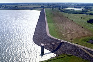
English: Aerial view of Bardwell Lake and Dam in Ellis County near Ennis, Texas, USA. The lake is nearly five miles long but this photograph shows only the dam and southernmost part of the lake. The lake is named for the nearby hamlet of Bardwell, Texas. View is to the east.
Coordinates: 32°15′5.13″N 96°38′24.74″W / 32.251425°N 96.6402056°W |
|||
| Location | Ellis County, Texas, USA | |||
| Date | (Caveat: Dates provided by U.S. Army Corps of Engineers Digital Visual Library are not reliable and may be wrong.) | |||
| Source |
U.S. Army Corps of Engineers Digital Visual Library Image page Image description page Digital Visual Library home page |
|||
| Author | U.S. Army Corps of Engineers, photographer not specified or unknown | |||
| Permission (Reusing this file) |
|
File history
Click on a date/time to view the file as it appeared at that time.
| Date/Time | Thumbnail | Dimensions | User | Comment | |
|---|---|---|---|---|---|
| current | 04:22, 10 May 2007 | | 1,500 × 1,000 (563 KB) | DanMS | {{Information | Description = {{en|Aerial view of Bardwell Lake and Dam in Ellis County near Ennis, Texas, USA. The lake is nearly five miles long but this photograph shows only the dam and southernmost part of the lake. The lake is named for the nearb |
File usage
The following pages on the English Wikipedia use this file (pages on other projects are not listed):
Global file usage
The following other wikis use this file:
- Usage on ca.wikipedia.org
- Usage on ceb.wikipedia.org
- Usage on ja.wikipedia.org
- Usage on www.wikidata.org