
Size of this preview: 800 × 514 pixels. Other resolutions: 320 × 205 pixels | 640 × 411 pixels | 1,024 × 657 pixels | 1,280 × 822 pixels | 2,560 × 1,644 pixels | 4,313 × 2,769 pixels.
Original file (4,313 × 2,769 pixels, file size: 3.98 MB, MIME type: image/jpeg)
| This is a file from the Wikimedia Commons. Information from its description page there is shown below. Commons is a freely licensed media file repository. You can help. |
Summary
| Description |
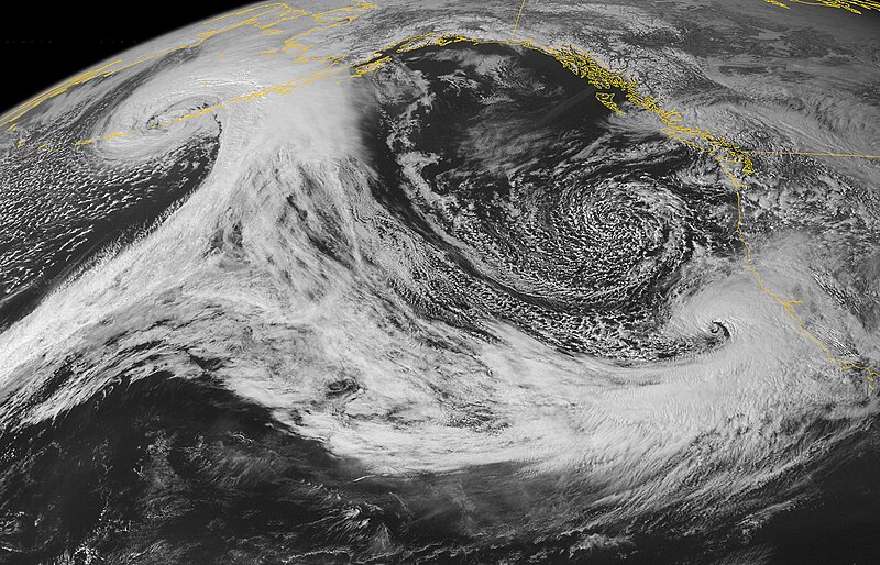
English: This image illustrates the relative positions of two storm systems over the North-eastern Pacific. |
| Date | |
| Source | NASA Earth Observatory |
| Author | NOAA Geostationary Satellite Server |
| Other versions |
|


Image captured by the Geostationary Operational Environment Satellite (GOES-11).
Licensing
| This file is in the public domain in the United States because it was solely created by NASA. NASA copyright policy states that "NASA material is not protected by copyright unless noted". (See Template:PD-USGov, NASA copyright policy page or JPL Image Use Policy.) | ||
 |
Warnings:
|
File history
Click on a date/time to view the file as it appeared at that time.
| Date/Time | Thumbnail | Dimensions | User | Comment | |
|---|---|---|---|---|---|
| current | 02:40, 21 July 2012 | | 4,313 × 2,769 (3.98 MB) | Earth100 | Cropped, and sharpen the definition |
| 11:31, 4 April 2011 |  | 11,885 × 10,819 (11.6 MB) | Originalwana | {{Information |Description ={{en|1=This image illustrates the relative positions of two storm systems over the North-eastern Pacific. }} |Source =[http://earthobservatory.nasa.gov/IOTD/view.php?id=49958 NASA Earth Observatory] |Author |
File usage
The following pages on the English Wikipedia use this file (pages on other projects are not listed):