.png)
.png)

Size of this preview: 499 × 599 pixels. Other resolutions: 200 × 240 pixels | 400 × 480 pixels | 784 × 941 pixels.
Original file (784 × 941 pixels, file size: 201 KB, MIME type: image/png)
| This is a file from the Wikimedia Commons. Information from its description page there is shown below. Commons is a freely licensed media file repository. You can help. |
.png)
Summary
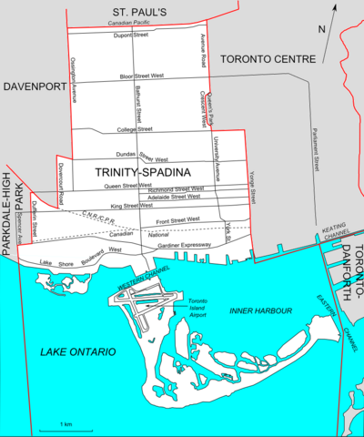
| Description | Map of the Ontario federal and provincial riding of Trinity-Spadina (boundaries defined federally in 2003 and adopted provincially in 2007) |
| Date | |
| Source | Own work |
| Author | Slyguy |
Licensing
| I, the copyright holder of this work, release this work into the public domain. This applies worldwide. In some countries this may not be legally possible; if so: I grant anyone the right to use this work for any purpose, without any conditions, unless such conditions are required by law. |
File history
Click on a date/time to view the file as it appeared at that time.
| Date/Time | Thumbnail | Dimensions | User | Comment | |
|---|---|---|---|---|---|
| current | 22:12, 29 December 2007 | | 784 × 941 (201 KB) | Slyguy~commonswiki | Image correction |
| 22:01, 29 December 2007 |  | 784 × 941 (201 KB) | Slyguy~commonswiki | {{Information |Description=Map of the Canadian federal political riding of Trinity-Spadina (boundaries as defined in 2003) |Source=self-made |Date=December 29, 2007 |Author= Slyguy |Permission= |other_versions= }} |
File usage
The following pages on the English Wikipedia use this file (pages on other projects are not listed):
Global file usage
The following other wikis use this file:
- Usage on zh.wikipedia.org
.png)