
Size of this preview: 800 × 533 pixels. Other resolutions: 320 × 213 pixels | 640 × 427 pixels | 1,024 × 683 pixels | 1,280 × 853 pixels | 2,560 × 1,707 pixels | 3,072 × 2,048 pixels.
Original file (3,072 × 2,048 pixels, file size: 5.15 MB, MIME type: image/jpeg)
| This is a file from the Wikimedia Commons. Information from its description page there is shown below. Commons is a freely licensed media file repository. You can help. |
Summary
| Description |
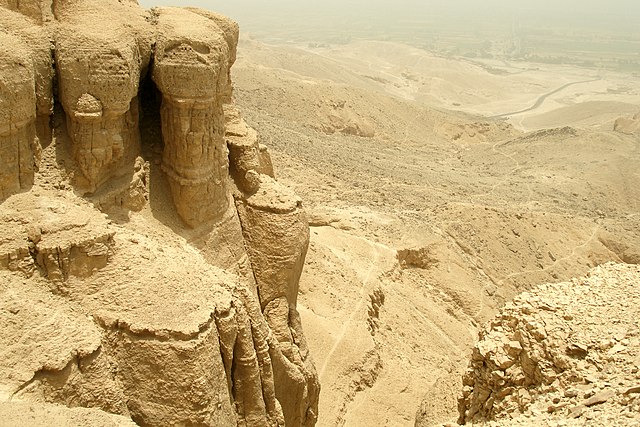
English: Al Qurn is the highest peak (420 m) in the Theban Hills, located on the western bank of the Nile, opposite modern Luxor. Its ancient name was Ta Dehent, or "the peak". Al Qurn is believed to be one of the entrances to the Duat (underworld). The whole Theban plateau was lifted up by the African faults, and then valleys cut down and the Nile excavated a large canyon. Theban Plateau, Theban Hills, Thebes, Luxor, Waset, Egypt.
Русский: Фиванское плато, Фиванские горы, Фивы, Луксор, Египет. |
| Date | |
| Source | Own work |
| Author | Vyacheslav Argenberg |

|
This image was taken by Vyacheslav Argenberg
If you have any questions, comments or queries, please contact me. |

|
Licensing
Vyacheslav Argenberg, the copyright holder of this work, hereby publishes it under the following license:
This file is licensed under the Creative Commons Attribution 4.0 International license.
Attribution: © Vyacheslav Argenberg / http://www.vascoplanet.com/
- You are free:
- to share – to copy, distribute and transmit the work
- to remix – to adapt the work
- Under the following conditions:
- attribution – You must give appropriate credit, provide a link to the license, and indicate if changes were made. You may do so in any reasonable manner, but not in any way that suggests the licensor endorses you or your use.
File history
Click on a date/time to view the file as it appeared at that time.
| Date/Time | Thumbnail | Dimensions | User | Comment | |
|---|---|---|---|---|---|
| current | 11:37, 18 July 2021 | | 3,072 × 2,048 (5.15 MB) | Argenberg | Uploaded own work with UploadWizard |
File usage
The following pages on the English Wikipedia use this file (pages on other projects are not listed):