No higher resolution available.
The.Land.map.jpg (369 × 270 pixels, file size: 40 KB, MIME type: image/jpeg)
Summary edit
| Description |
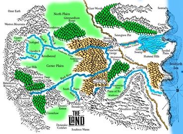
Lynn Plagge's map of "The Land," based on The Chronicles of Thomas Covenant by Stephen R. Donaldson. |
|---|---|
| Source | |
| Portion used |
Complete |
| Low resolution? |
The map is not rendered in the highest available resolution. |
| Other information |
Originally published 1977 |
| Article | |
|---|---|
| Purpose of use |
Its inclusion in the article adds significantly to the article because it shows the setting of the novels. |
| Replaceable? |
No free equivalent exists |
Licensing edit
 | This work is copyrighted (or assumed to be copyrighted) and unlicensed. It does not fall into one of the blanket acceptable non-free content categories listed at Wikipedia:Non-free content § Images or Wikipedia:Non-free content § Audio clips, and it is not covered by a more specific non-free content license listed at Category:Wikipedia non-free file copyright templates. However, it is believed that the use of this work:
qualifies as fair use under United States copyright law. Any other uses of this image, on Wikipedia or elsewhere, may be copyright infringement. See Wikipedia:Non-free content and Wikipedia:Copyrights. |
File history
Click on a date/time to view the file as it appeared at that time.
| Date/Time | Thumbnail | Dimensions | User | Comment | |
|---|---|---|---|---|---|
| current | 23:31, 8 February 2017 | | 369 × 270 (40 KB) | DatBot (talk | contribs) | Reduce size of non-free image (BOT - disable) |
| 07:22, 9 November 2010 | No thumbnail | 937 × 687 (319 KB) | Goustien (talk | contribs) | ==Summary== {{Non-free image data |Description = Lynn Plagge's map of "The Land," based on ''The Chronicles of Thomas Covenant, the Unbeliever'' by Stephen R. Donaldson. |Source = http://theland.antgear.com/map.jpg |Portion |
You cannot overwrite this file.
File usage
The following pages on the English Wikipedia use this file (pages on other projects are not listed):