Swisstopo_Bluemlisalp_50.png (316 × 316 pixels, file size: 48 KB, MIME type: image/png)
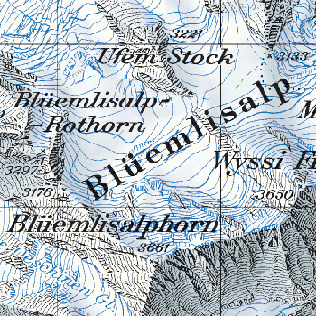
sample of the Swisstopo 1:50,000 map of Switzerland, showing Blüemlisalp.
 | This work is copyrighted (or assumed to be copyrighted) and unlicensed. It does not fall into one of the blanket acceptable non-free content categories listed at Wikipedia:Non-free content § Images or Wikipedia:Non-free content § Audio clips, and it is not covered by a more specific non-free content license listed at Category:Wikipedia non-free file copyright templates. However, it is believed that the use of this work:
qualifies as fair use under United States copyright law. Any other uses of this image, on Wikipedia or elsewhere, may be copyright infringement. See Wikipedia:Non-free content and Wikipedia:Copyrights. |
| Description |
1:50,000 National Map of Switzerland |
|---|---|
| Source | |
| Portion used |
Small sample around Blüemlisalp, too small to be of any practical use. |
| Low resolution? |
No. A high-resolution scan is required so that details can be seen. |
| Article | |
|---|---|
| Purpose of use |
Used to illustrate the National Map of Switzerland in an article on Swiss cartography. |
| Replaceable? |
Not replaceable, illustrating a copyrighted map. |
File history
Click on a date/time to view the file as it appeared at that time.
| Date/Time | Thumbnail | Dimensions | User | Comment | |
|---|---|---|---|---|---|
| current | 01:02, 31 December 2017 | | 316 × 316 (48 KB) | DatBot (talk | contribs) | Reduce size of non-free image (BOT - disable) |
| 12:40, 14 November 2006 | No thumbnail | 350 × 350 (57 KB) | Dbachmann (talk | contribs) | sample of the Swisstopo 1:50,000 map of Switzerland, showing Blüemlisalp. {{fairuse}} |
You cannot overwrite this file.