Size of this PNG preview of this SVG file: 592 × 600 pixels. Other resolutions: 237 × 240 pixels | 474 × 480 pixels | 758 × 768 pixels | 1,011 × 1,024 pixels | 2,021 × 2,048 pixels | 676 × 685 pixels.
Original file (SVG file, nominally 676 × 685 pixels, file size: 368 KB)
File history
Click on a date/time to view the file as it appeared at that time.
| Date/Time | Thumbnail | Dimensions | User | Comment | |
|---|---|---|---|---|---|
| current | 15:37, 23 May 2021 |  | 676 × 685 (368 KB) | Furfur | resolution |
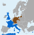
| 15:36, 23 May 2021 |  | 676 × 685 (247 KB) | Furfur | == {{int:filedesc}} == {{Information |Description={{User:Medium69/Traduction}} {{de|1=Staaten der Stresa-Front und das nationalsozialistische Deutschland 1935.}} |Source={{Derived from|Blank map of Europe 1929-1938.svg|by1=Alphhaton|b2=Flappiefh|by3=AHC300}} |Date=2021-05-23 |Author={{U|Furfur}} |Permission={{self|GFDL|cc-by-sa-4.0}} |Other versions= |Other fields={{Igen|A|+|%|s=m}} }} Category:SVG maps showing history |
File usage
The following 2 pages use this file:
Global file usage
The following other wikis use this file:
- Usage on de.wikipedia.org
- Usage on he.wikipedia.org
- Usage on tr.wikipedia.org
- Usage on zh.wikipedia.org
