
Size of this preview: 798 × 141 pixels. Other resolutions: 320 × 57 pixels | 640 × 113 pixels | 1,024 × 181 pixels | 1,280 × 226 pixels | 10,000 × 1,768 pixels.
Original file (10,000 × 1,768 pixels, file size: 10.09 MB, MIME type: image/jpeg)
| This is a file from the Wikimedia Commons. Information from its description page there is shown below. Commons is a freely licensed media file repository. You can help. |
| This is a featured picture, which means that members of the community have identified it as one of the finest images on the English Wikipedia, adding significantly to its accompanying article. If you have a different image of similar quality, be sure to upload it using the proper free license tag, add it to a relevant article, and nominate it. |
| This image was selected as picture of the day on the English Wikipedia for August 1, 2011. |
| Description |
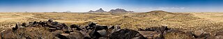
Deutsch: Panorama von klein Spitzkoppe, Spitzkoppe und Erongogebirge
English: 360° panorama over the small Spitzkoppe, the Spitzkoppe and the Erongogebirge. Namibia.
Français : Vue panoramique à 360° sur le petit Spitzkoppe, le Spitzkoppe et le Erongogebirge. Namibie. |
| Date | |
| Source | Own work |
| Author | Ikiwaner |
| Permission (Reusing this file) |
GNU Free Documentation License v1.2 only |
| Camera location | | View this and other nearby images on: OpenStreetMap |
|---|
| 360° | View in 360° panoramic viewer
|
|---|
|


|
Permission is granted to copy, distribute and/or modify this document under the terms of the GNU Free Documentation License, Version 1.2 only as published by the Free Software Foundation; with no Invariant Sections, no Front-Cover Texts, and no Back-Cover Texts. A copy of the license is included in the section entitled GNU Free Documentation License. | 1.2 only |
File history
Click on a date/time to view the file as it appeared at that time.
| Date/Time | Thumbnail | Dimensions | User | Comment | |
|---|---|---|---|---|---|
| current | 16:00, 16 October 2012 | 10,000 × 1,768 (10.09 MB) | Rotatebot | Bot: Image rotated by 180° | |
| 14:15, 16 October 2012 | 10,000 × 1,768 (10.09 MB) | Rotatebot | Bot: Image rotated by 180° | ||
| 13:58, 10 January 2010 | 10,000 × 1,773 (9.97 MB) | Alchemist-hp | Gaussian blur correction at the sky. If you don't like it then revert it. | ||
| 17:57, 19 October 2009 | 10,000 × 1,773 (10.63 MB) | Ikiwaner | {{Information |Description={{de|Panorama von klein Spitzkoppe, Spitzkoppe und Erongogebirge}} {{Pano360|horizon=30}} |Source={{Own}} |Date=siehe Bild-Metadaten |Author=Ikiwaner |Permission=GNU Free Documentation License v1.2 only |other_ |
File usage
The following pages on the English Wikipedia use this file (pages on other projects are not listed):
- Spitzkoppe
- Talk:Spitzkoppe
- User talk:Ikiwaner
- Wikipedia:Featured picture candidates/File:Spitzkoppe 360 Panorama.jpg
- Wikipedia:Featured picture candidates/January-2010
- Wikipedia:Featured pictures/Places/Panorama
- Wikipedia:Featured pictures thumbs/21
- Wikipedia:Main Page history/2011 August 1
- Wikipedia:Picture of the day/August 2011
- Wikipedia:WikiProject Mountains/Recognized content
- Wikipedia:Wikipedia Signpost/2010-01-04/Features and admins
- Wikipedia:Wikipedia Signpost/Single/2010-01-04
- Template:POTD/2011-08-01
Global file usage
The following other wikis use this file:
- Usage on ar.wikipedia.org
- Usage on ckb.wikipedia.org
- Usage on de.wikipedia.org
- Usage on es.wikipedia.org
- Wikipedia:Imágenes destacadas/Lugares/África
- Wikipedia:Recurso del día/401 - 500
- Wikipedia:Candidatos a recursos destacados/Spitzkoppe 360 Panorama.jpg
- Plantilla:RDD/441
- Wikipedia:Candidatos a recursos destacados/Enero-2010
- Wikipedia:Recurso del día/febrero de 2011
- Wikipedia:Recurso del día/octubre de 2012
- Wikipedia:Recurso del día/octubre de 2014
- Wikipedia:Recurso del día/marzo de 2017
- Wikipedia:Recurso del día/mayo de 2019
- Wikipedia:Recurso del día/noviembre de 2021
- Usage on es.wikiversity.org
- Usage on fa.wikipedia.org
- Usage on fr.wikipedia.org
- Usage on gn.wikipedia.org
- Usage on he.wikipedia.org
- Usage on ka.wikipedia.org
- Usage on kn.wikipedia.org
- Usage on mg.wikipedia.org
- Usage on pl.wikipedia.org
- Usage on pnb.wikipedia.org
- Usage on pt.wikipedia.org
- Usage on tr.wikipedia.org
- Usage on vi.wikipedia.org
- Usage on xmf.wikipedia.org