.png)
.png&action=edit&redlink=1)

Size of this preview: 439 × 599 pixels. Other resolutions: 176 × 240 pixels | 352 × 480 pixels | 749 × 1,022 pixels.
Original file (749 × 1,022 pixels, file size: 77 KB, MIME type: image/png)
| This is a file from the Wikimedia Commons. Information from its description page there is shown below. Commons is a freely licensed media file repository. You can help. |
.png)
Summary
| Description | Mapa de la América española a finales del siglo XVIII / Map of Spanish America (XVIII century) |
| Date | |
| Source | Own work |
| Author | Jluisrs |
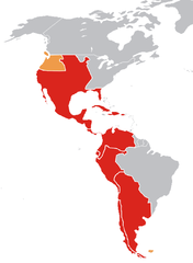
Leyenda
Mapa del es:Imperio Español en América a finales del siglo XVIII en su máxima expansión en ese continente.
- En rojo, los virreinatos y demás colonias.
- En amarillo oscuro, territorios disputados o reclamados por España.
Legend
Map of the w:Spanish Empire in America in the XVIII century.
- In red, Spanish posessions.
- In orange, reclamations and posessions where the Spanish had de jure authority only.
Licensing
| I, the copyright holder of this work, release this work into the public domain. This applies worldwide. In some countries this may not be legally possible; if so: I grant anyone the right to use this work for any purpose, without any conditions, unless such conditions are required by law. |
File history
Click on a date/time to view the file as it appeared at that time.
| Date/Time | Thumbnail | Dimensions | User | Comment | |
|---|---|---|---|---|---|
| current | 20:37, 22 April 2007 | | 749 × 1,022 (77 KB) | Jluisrs | {{Information |Description= Mapa de la América española a finales del siglo XVII / Map of Spanish America (XVIII century) |Source=self-made |Date= 22-4-2007 |Author= Jluisrs }} |
File usage
The following pages on the English Wikipedia use this file (pages on other projects are not listed):
Global file usage
The following other wikis use this file:
- Usage on be.wikipedia.org
- Usage on de.wikipedia.org
- Spanisches Kolonialreich
- Real Audiencia
- Real Audiencia de Quito
- Vorlage:Navigationsleiste Real Audiencias im Spanischen Kolonialreich
- Real Audiencia von Chile
- Real Audiencia von Charcas
- Real Audiencia von Cuzco
- Real Audiencia von Buenos Aires
- Real Audiencia von Lima
- Real Audiencia von Santa Fe de Bogotá
- Real Audiencia von Caracas
- Real Audiencia von Panama
- Real Audiencia von Mexico
- Real Audiencia von Santo Domingo
- Real Audiencia von Guadalajara
- Real Audiencia von Guatemala
- Real Audiencia von Manila
- Usage on es.wikipedia.org
- Usage on fa.wikipedia.org
- Usage on hr.wikipedia.org
- Usage on it.wikipedia.org
- Usage on ka.wikipedia.org
- Usage on lt.wikipedia.org
- La Platos vicekaralystė
- Naujasis Kuršas
- Amerikos kolonizacija
- Prancūzijos Gviana
- Ispanijos kolonijos Amerikoje
- Akadija
- Moskitų Krantas
- Naujoji Ispanija
- Vinlandas
- Danijos kolonijos Amerikoje
- Anglijos kolonijos Amerikoje
- Prancūzijos kolonijos Amerikoje
- Nyderlandų kolonijos Amerikoje
- Peru vicekaralystė
- Naujoji Prancūzija
- Barbadoso istorija
- Naujosios Granados vicekaralystė
- Naujoji Granados karalystė
- Naujoji Andalūzija
- Ispanijos Vakarų Indijos
- Britų Vest Indija
- Nyderlandų Vakarų Indijos
- Virdžinijos kolonija
- Plimuto kolonija
- Masačusetso įlankos kolonija
- Naujieji Nyderlandai
- Naujosios Kastilijos gubernatorystė
View more global usage of this file.
.png)
.png)