
Size of this preview: 800 × 440 pixels. Other resolutions: 320 × 176 pixels | 640 × 352 pixels | 994 × 547 pixels.
Original file (994 × 547 pixels, file size: 251 KB, MIME type: image/jpeg)
| This is a file from the Wikimedia Commons. Information from its description page there is shown below. Commons is a freely licensed media file repository. You can help. |
Summary
| Description |
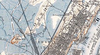
English: Map of Snake Hill. |
| Date | |
| Source | USGS Paterson, NJ Qaudrangle Map edition of Feb. 1900. Scale 1:62500 Countour interval 20 feet |
| Author | USGS |
Licensing
This image is in the public domain in the United States because it only contains materials that originally came from the United States Geological Survey, an agency of the United States Department of the Interior. For more information, see the official USGS copyright policy.
|
Original upload log
The original description page was here. All following user names refer to en.wikipedia.
- 2007-10-10 21:03 Cuzuco 994×547× (257455 bytes) Section scan of USGS map of Snake Hill in 1900.
File history
Click on a date/time to view the file as it appeared at that time.
| Date/Time | Thumbnail | Dimensions | User | Comment | |
|---|---|---|---|---|---|
| current | 05:44, 24 May 2011 | | 994 × 547 (251 KB) | Nightscream |
File usage
The following pages on the English Wikipedia use this file (pages on other projects are not listed):