
Size of this preview: 422 × 599 pixels. Other resolutions: 169 × 240 pixels | 451 × 640 pixels.
Original file (451 × 640 pixels, file size: 156 KB, MIME type: image/jpeg)
| This is a file from the Wikimedia Commons. Information from its description page there is shown below. Commons is a freely licensed media file repository. You can help. |
Summary
| Description |
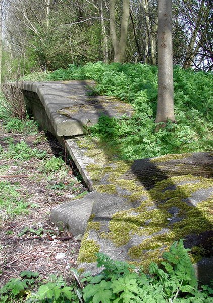
English: Skirlaugh railway station, Ellerby, East Riding of Yorkshire, England. End of the platform on the site of Skirlaugh Station, where the dismantled Hull & Hornsea Railway crosses the A165 Oubrough Lane, west of Ellerby. The railway opened in 1864 and lasted until 1965. Skirlaugh Station was closed to passengers in 1957 and entirely in 1963 and the path of the railway now forms the Hornsea Rail Trail and the eastern stretch of the Trans Pennine Trail. The Trans Pennine Trail runs for 215 miles from Hornsea to Southport and was officially opened in September 2001. There's a small building on the Ordnance Survey 1:25000 scale map just north of the former level crossing here at Oubrough, but this building no longer exists. |
| Date | |
| Source | From geograph.org.uk |
| Author | Paul Glazzard |
| Permission (Reusing this file) |
Creative Commons Attribution Share-alike license 2.0 |
| Camera location | | View this and other nearby images on: OpenStreetMap |
|---|
| Object location | | View this and other nearby images on: OpenStreetMap |
|---|
_region:GB-GBN_heading:45.00&language=en)
Licensing

|
This image was taken from the Geograph project collection. See this photograph's page on the Geograph website for the photographer's contact details. The copyright on this image is owned by Paul Glazzard and is licensed for reuse under the Creative Commons Attribution-ShareAlike 2.0 license.
|
This file is licensed under the Creative Commons Attribution-Share Alike 2.0 Generic license.
Attribution: Paul Glazzard
- You are free:
- to share – to copy, distribute and transmit the work
- to remix – to adapt the work
- Under the following conditions:
- attribution – You must give appropriate credit, provide a link to the license, and indicate if changes were made. You may do so in any reasonable manner, but not in any way that suggests the licensor endorses you or your use.
- share alike – If you remix, transform, or build upon the material, you must distribute your contributions under the same or compatible license as the original.
File history
Click on a date/time to view the file as it appeared at that time.
| Date/Time | Thumbnail | Dimensions | User | Comment | |
|---|---|---|---|---|---|
| current | 06:45, 30 April 2008 | | 451 × 640 (156 KB) | Edward | w:Skirlaugh railway station {{geograph|775447|Paul Glazzard}} Original description: '''Skirlaugh Station''' End of the platform on the site of Skirlaugh Station, where the dismantled Hull & Hornsea Railway crosses the A165 Oubrough Lane, west |
File usage
The following pages on the English Wikipedia use this file (pages on other projects are not listed):
Global file usage
The following other wikis use this file:
- Usage on www.wikidata.org