.png)
.png&action=edit&redlink=1)
Size of this preview: 465 × 600 pixels. Other resolutions: 186 × 240 pixels | 541 × 698 pixels.
Original file (541 × 698 pixels, file size: 33 KB, MIME type: image/png)
| This is a file from the Wikimedia Commons. Information from its description page there is shown below. Commons is a freely licensed media file repository. You can help. |
.png)
Summary
| Description |
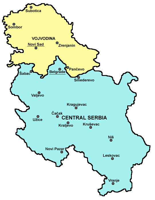
English: map of administrative divisions in Serbia, by the view of government of Kosovo and part of international community, from 2008 (when Kosovo declared independence) to 2009 (when Serbian authorities adopted a law that formed 5 new statistical regions in the territory formerly known as Central Serbia).
Српски / srpski: мапа административне поделе Србије према становишту владе Косова и дела међународне заједнице, између 2008. године (када је Косово прогласило независност) и 2009. године (када су власти у Србији усвојиле закон којим је формирано 5 нових статистичких региона на простору који је до тада био познат као Централна Србија). |
| Date |
27 February 2008 (original upload date) (Original text: 27 Feb 2008) |
| Source |
Transferred from en.wikipedia to Commons by Smooth_O using CommonsHelper. (Original text: self-made) |
| Author | Map was originally created by User:PANONIAN - it was modified and uploaded again by 2007apm (talk) and again modified by User:PANONIAN - |
Licensing
| I, the copyright holder of this work, release this work into the public domain. This applies worldwide. In some countries this may not be legally possible; if so: I grant anyone the right to use this work for any purpose, without any conditions, unless such conditions are required by law. |
Original upload log
The original description page was here. All following user names refer to en.wikipedia.
- 2008-06-22 21:17 2007apm 448×599×8 (97945 bytes) Reverted to version as of 21:06, 27 February 2008
- 2008-06-04 20:01 Boki13 448×599×8 (105820 bytes) Reverted to version as of 19:01, 13 April 2008
- 2008-04-14 11:35 2007apm 448×599×8 (97945 bytes) Reverted to version as of 13:21, 24 March 2008
- 2008-04-13 19:01 Boki13 448×599×8 (105820 bytes) Reverted to version as of 19:23, 22 March 2008
- 2008-03-24 13:21 2007apm 448×599×8 (97945 bytes) Reverted to version as of 21:06, 27 February 2008
- 2008-03-22 19:23 Boki13 448×599×8 (105820 bytes)
- 2008-02-27 21:06 2007apm 448×599×8 (97945 bytes) {{Information |Description=Map if Serbia |Source=self-made |Date=27 Feb 2008 |Location= |Author=~~~ |other_versions= }}
File history
Click on a date/time to view the file as it appeared at that time.
| Date/Time | Thumbnail | Dimensions | User | Comment | |
|---|---|---|---|---|---|
| current | 10:07, 15 September 2010 | | 541 × 698 (33 KB) | PANONIAN | improved version |
| 21:44, 12 June 2009 |  | 477 × 615 (22 KB) | PANONIAN | ||
| 11:32, 1 July 2008 |  | 448 × 599 (96 KB) | File Upload Bot (Magnus Manske) | {{BotMoveToCommons|en.wikipedia}} {{Information |Description={{en|Map if Serbia}} |Source=Transferred from [http://en.wikipedia.org en.wikipedia]; transfered to Commons by User:Smooth_O using [http://tools.wikimedia.de/~magnus/commonshelper.php Commo |
File usage
No pages on the English Wikipedia use this file (pages on other projects are not listed).
Global file usage
The following other wikis use this file:
- Usage on bs.wikipedia.org
- Usage on hu.wikipedia.org
- Usage on mk.wikipedia.org
- Usage on sh.wikipedia.org
.png)