
Size of this preview: 800 × 533 pixels. Other resolutions: 320 × 213 pixels | 640 × 427 pixels | 1,024 × 683 pixels | 1,500 × 1,000 pixels.
Original file (1,500 × 1,000 pixels, file size: 590 KB, MIME type: image/jpeg)
| This is a file from the Wikimedia Commons. Information from its description page there is shown below. Commons is a freely licensed media file repository. You can help. |
| Description |
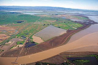
English: Sears Point in Sonoma County, California, USA. Sears Point is the end of a range of hills or low mountains ending at the northern end of San Pablo Bay and the Napa Sonoma Marsh, which is the flat marshy land across the picture. The Petaluma River flows into the bay at the bottom of the picture.
Coordinates: 38°9′3.46″N 122°27′8.99″W / 38.1509611°N 122.4524972°W |
|||
| Location | Sonoma County, California, USA | |||
| Date | not specified or unknown | |||
| Source |
U.S. Army Corps of Engineers Digital Visual Library Image page Image description page Digital Visual Library home page |
|||
| Author | U.S. Army Corps of Engineers, photographer not specified or unknown | |||
| Permission (Reusing this file) |
|
File history
Click on a date/time to view the file as it appeared at that time.
| Date/Time | Thumbnail | Dimensions | User | Comment | |
|---|---|---|---|---|---|
| current | 04:11, 4 May 2007 | | 1,500 × 1,000 (590 KB) | DanMS | {{Information | Description = {{en|Sears Point in Sonoma County, California, USA. Sears Point is the end of a range of hills or low mountains ending at the northern end of San Pablo Bay and the Napa Sonoma Marsh, which is the flat marshy land across th |
File usage
The following pages on the English Wikipedia use this file (pages on other projects are not listed):
Global file usage
The following other wikis use this file:
- Usage on nl.wikipedia.org
- Usage on www.wikidata.org