
Size of this preview: 400 × 599 pixels. Other resolutions: 160 × 240 pixels | 320 × 480 pixels | 513 × 768 pixels | 683 × 1,024 pixels | 1,367 × 2,048 pixels | 4,016 × 6,016 pixels.
Original file (4,016 × 6,016 pixels, file size: 18.83 MB, MIME type: image/jpeg)
| This is a file from the Wikimedia Commons. Information from its description page there is shown below. Commons is a freely licensed media file repository. You can help. |
Summary
| Description |
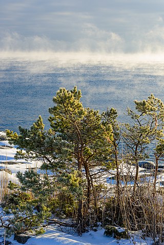
English: Scots Pine (Pinus sylvestris), east part of Utö, Haninge Municipality, Stockholm archipelago. In the background the Baltic Sea, with some sea smoke.
Español: Pino silvestre (Pinus sylvestris) al este de Utö, Haninge, provincia de Estocolmo, Suecia. En el fondo, el mar Báltico cubierto de niebla de mar.
Polski: Sosna zwyczajna (Pinus sylvestris) we wschodniej części wyspy Utö w archipelagu Sztokholmskim administracyjnie należącej do gminy Haninge w regionie Sztokholm, w Szwecji. W tle widoczny jest osnuty mgłą Bałtyk.
Čeština: Borovice lesní (Pinus sylvestris), východní část ostrova Utö, Stockholmské souostroví, Baltské moře, Švédsko.
Magyar: Erdeifenyő (Pinus sylvestris) Utö keleti részén (Haninge község, Stockholm megye, Svédország). A háttérben a Balti-tenger némi tengeri köddel
Italiano: Alcuni pini silvestri (Pinus sylvestris), sull'isola di Utö, nell'arcipelago di Stoccolma (Svezia). Sullo sfondo, il Mar Baltico fumante.
Македонски: Бел бор (Pinus sylvestris) во источниот дел на островот Уте, општина Ханинге, Стокхолмски Архипелаг, Шведска.
Português: Pinheiro-silvestre (Pinus sylvestris) a leste de Utö, Haninge, arquipélago de Estocolmo, Suécia. |
||
| Date | |||
| Source | Flickr: Utö, January 2013 IV | ||
| Author | Arild Vågen | ||
| Permission (Reusing this file) |
This file is licensed under the Creative Commons Attribution-Share Alike 2.0 Generic license.
|
| Object location | | View this and other nearby images on: OpenStreetMap |
|---|
This file was made possible through the pool of technology at Wikimedia Sverige. |
Assessment
This image was selected as picture of the day on Wikimedia Commons for 19 January 2018. It was captioned as follows: English: Scots Pine (Pinus sylvestris), east part of Utö, Haninge Municipality, Stockholm archipelago, Sweden. In the background the Baltic Sea, with some sea smoke. Other languages:
Čeština: Borovice lesní (Pinus sylvestris), východní část ostrova Utö, Stockholmské souostroví, Baltské moře, Švédsko. English: Scots Pine (Pinus sylvestris), east part of Utö, Haninge Municipality, Stockholm archipelago, Sweden. In the background the Baltic Sea, with some sea smoke. Español: Pino silvestre (Pinus sylvestris) al este de Utö, Haninge, provincia de Estocolmo, Suecia. En el fondo, el mar Báltico cubierto de niebla de mar. Italiano: Alcuni pini silvestri (Pinus sylvestris), sull'isola di Utö, nell'arcipelago di Stoccolma (Svezia). Sullo sfondo, il Mar Baltico fumante. Magyar: Erdeifenyő (Pinus sylvestris) Utö keleti részén (Haninge község, Stockholm megye, Svédország). A háttérben a Balti-tenger némi tengeri köddel Polski: Sosna zwyczajna (Pinus sylvestris) we wschodniej części wyspy Utö w archipelagu Sztokholmskim administracyjnie należącej do gminy Haninge w regionie Sztokholm, w Szwecji. W tle widoczny jest osnuty mgłą Bałtyk. Português: Pinheiro-silvestre (Pinus sylvestris) a leste de Utö, Haninge, arquipélago de Estocolmo, Suécia. Македонски: Бел бор (Pinus sylvestris) во источниот дел на островот Уте, општина Ханинге, Стокхолмски Архипелаг, Шведска. |
|
File history
Click on a date/time to view the file as it appeared at that time.
| Date/Time | Thumbnail | Dimensions | User | Comment | |
|---|---|---|---|---|---|
| current | 08:02, 20 January 2013 | | 4,016 × 6,016 (18.83 MB) | ArildV | remove CA, |
| 23:25, 19 January 2013 |  | 4,016 × 6,016 (19.65 MB) | Flickr upload bot | Uploaded from http://flickr.com/photo/62405357@N03/8396620438 using Flickr upload bot |
File usage
The following pages on the English Wikipedia use this file (pages on other projects are not listed):
Global file usage
The following other wikis use this file:
- Usage on be-tarask.wikipedia.org
- Usage on crh.wikipedia.org
- Usage on cv.wikipedia.org
- Usage on hu.wikipedia.org
- Usage on hy.wikipedia.org
- Usage on it.wiktionary.org
- Usage on ka.wikipedia.org
- Usage on ko.wikipedia.org
- Usage on lbe.wikipedia.org
- Usage on lez.wikipedia.org
- Usage on mg.wikipedia.org
- Usage on mk.wikipedia.org
- Usage on os.wikipedia.org
- Usage on pt.wikipedia.org
- Usage on ru.wikipedia.org
- Usage on ru.wikinews.org
- Usage on sah.wikipedia.org
- Usage on smn.wikipedia.org
- Usage on sv.wikipedia.org
- Usage on tt.wikipedia.org
- Usage on uk.wikipedia.org
- Usage on vep.wikipedia.org
- Usage on war.wikipedia.org
- Usage on zh.wikipedia.org