
Size of this preview: 800 × 508 pixels. Other resolutions: 320 × 203 pixels | 640 × 406 pixels | 1,024 × 650 pixels | 1,497 × 950 pixels.
Original file (1,497 × 950 pixels, file size: 1.71 MB, MIME type: image/png)
| This is a file from the Wikimedia Commons. Information from its description page there is shown below. Commons is a freely licensed media file repository. You can help. |
Summary
| Description |
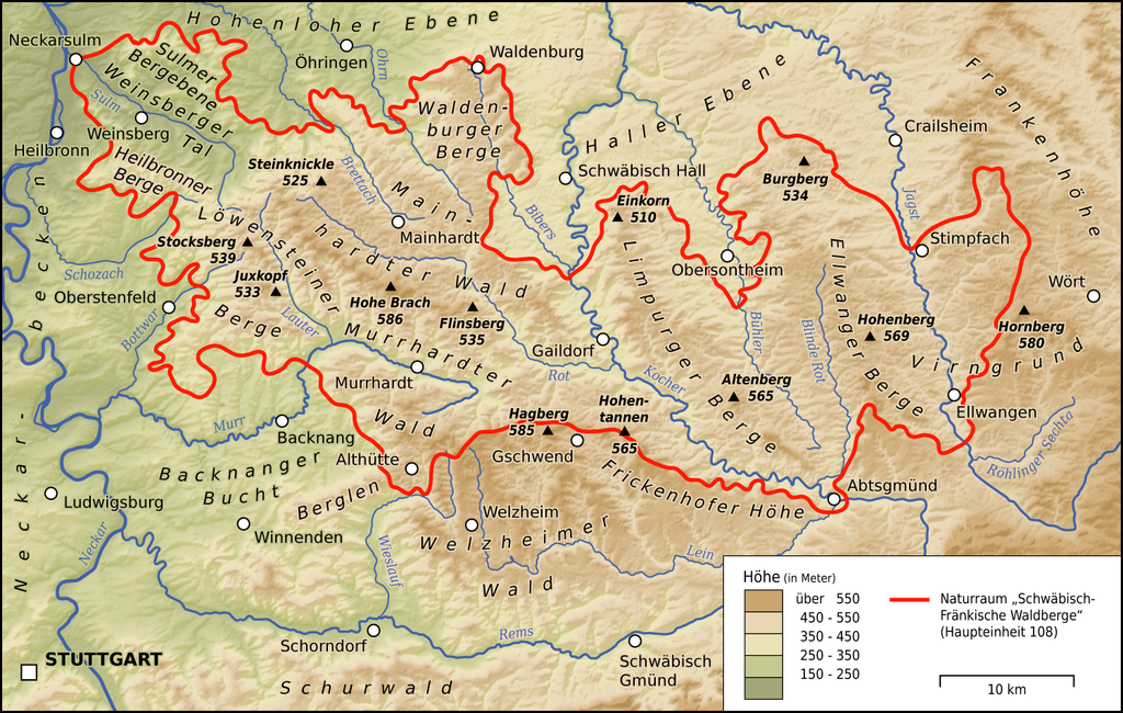
Deutsch: Karte des Naturraums Schwäbisch-Fränkische Waldberge (Haupteinheit 108) |
| Date | |
| Source |
Own work Map was created using
|
| Author | Thoroe |
| Permission (Reusing this file) |
Map data (c) OpenStreetMap (and) contributors, CC-BY-SA |
| Object location | | View this and other nearby images on: OpenStreetMap |
|---|

|
This map has been made or improved in the German Kartenwerkstatt (Map Lab). You can propose maps to improve as well.
|
Licensing
This file is licensed under the Creative Commons Attribution-Share Alike 2.0 Generic license.
Attribution: Thomas Römer/OpenStreetMap data
- You are free:
- to share – to copy, distribute and transmit the work
- to remix – to adapt the work
- Under the following conditions:
- attribution – You must give appropriate credit, provide a link to the license, and indicate if changes were made. You may do so in any reasonable manner, but not in any way that suggests the licensor endorses you or your use.
- share alike – If you remix, transform, or build upon the material, you must distribute your contributions under the same or compatible license as the original.
File history
Click on a date/time to view the file as it appeared at that time.
| Date/Time | Thumbnail | Dimensions | User | Comment | |
|---|---|---|---|---|---|
| current | 11:40, 3 May 2013 | | 1,497 × 950 (1.71 MB) | Thoroe | +Sulmer Bergebene +Schurwald +Legende geändert |
| 10:39, 29 September 2010 |  | 1,183 × 751 (1.32 MB) | Thoroe | Virngrund "verlegt"; Legende ergänzt | |
| 20:21, 29 July 2010 |  | 1,183 × 751 (1.33 MB) | Thoroe | Naturraum-Abgrenzung korrigiert; einige Orte/Berge ergänzt | |
| 23:05, 28 July 2010 |  | 1,183 × 691 (1.25 MB) | Thoroe | Exaktere Abgrenzung der einzelnen Gebiete | |
| 18:44, 28 July 2010 |  | 1,183 × 691 (1.25 MB) | Thoroe | {{Information |Description={{de|1=Karte des Naturraums "Schwäbisch-Fränkische Waldberge"}} |Source={{own}}{{Adobe Illustrator}} |Author=Thoroe |Date=2010-07-28 |Permission= |other_versions= }} {{Obje |
File usage
The following pages on the English Wikipedia use this file (pages on other projects are not listed):
Global file usage
The following other wikis use this file:
- Usage on arz.wikipedia.org
- Usage on ceb.wikipedia.org
- Usage on de.wikipedia.org
- Schwäbisch-Fränkische Waldberge
- Topografische Karte
- Sulm (Neckar)
- Löwensteiner Berge
- Murrhardter Wald
- Weinsberger Tal
- Haller Ebene
- Mainhardter Wald
- Hohenloher Ebene
- Juxkopfturm
- Welzheimer Wald
- Berglen (Landschaft)
- Steinknickle
- Waldenburger Berge
- Limpurger Berge
- Ellwanger Berge
- Juxkopf
- Diskussion:Hohenlohe
- Virngrund
- Hornberg (Virngrund)
- Stocksberg (Berg)
- Frickenhofer Höhe
- Benutzer:Thoroe
- Benutzer:KaterBegemot/Kartografen
- Wikipedia:Kartenwerkstatt/Archiv/2010-08
- Benutzer:Ougneem/Eschelbacher Steige
- Hagberg (Welzheimer Wald)
- Heilbronner Berge
- Sulmer Bergebene
- Urbrenz
- Burgberg-Vorhöhen und Speltachbucht
- Benutzer:Silvicola/Vellberger Bucht
- Benutzer Diskussion:Crushedcoldice/Schwäbischer Wald
- Benutzer:Triplec85/BW-AA
- Benutzer:Triplec85/BW-1
- Usage on fr.wikipedia.org
- Usage on lld.wikipedia.org
- Usage on www.wikidata.org