
Size of this preview: 402 × 600 pixels. Other resolutions: 161 × 240 pixels | 322 × 480 pixels | 515 × 768 pixels | 686 × 1,024 pixels | 1,382 × 2,061 pixels.
Original file (1,382 × 2,061 pixels, file size: 335 KB, MIME type: image/jpeg)
| This is a file from the Wikimedia Commons. Information from its description page there is shown below. Commons is a freely licensed media file repository. You can help. |
|
This is an image of a place or building that is listed on the National Register of Historic Places in the United States of America. Its reference number is 70000644. |
Summary
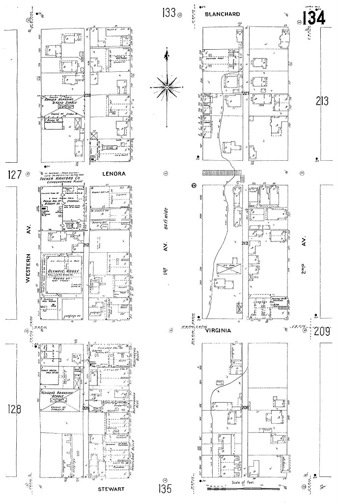
| Description | 1905 map of part of Seattle, Washington. The map extends from Western Avenue northeast to Second Avenue and from Stewart Street northwest to Blanchard Street. Above Virginia Street is part of the Belltown neighborhood. The block at lower left is now part of the city-designated Pike Place Market Historical District. The remainder is the northwest corner of the downtown core. |
| Date | |
| Source | Map 134, Insurance Maps of Seattle, Volume Two, Sanborn Map Company, 11 Broadway, New York, reproduced on the "Digital Sanborn Maps 1867-1970" online (subscription) database |
| Author | Pacific Dept Sanborn Map Company (San Francisco) |
| Permission (Reusing this file) |
PD-US |
| Object location | | View this and other nearby images on: OpenStreetMap |
|---|
Licensing
This media file is in the public domain in the United States. This applies to U.S. works where the copyright has expired, often because its first publication occurred prior to January 1, 1929, and if not then due to lack of notice or renewal. See this page for further explanation.
|
 | |
 |
This image might not be in the public domain outside of the United States; this especially applies in the countries and areas that do not apply the rule of the shorter term for US works, such as Canada, Mainland China (not Hong Kong or Macao), Germany, Mexico, and Switzerland. The creator and year of publication are essential information and must be provided. See Wikipedia:Public domain and Wikipedia:Copyrights for more details.
|
File history
Click on a date/time to view the file as it appeared at that time.
| Date/Time | Thumbnail | Dimensions | User | Comment | |
|---|---|---|---|---|---|
| current | 18:07, 4 October 2008 | | 1,382 × 2,061 (335 KB) | Jmabel | == Summary == {{Information |Description=1905 map of part of Seattle, Washington. The map extends from Western Avenue northeast to Second Avenue and from Stewart Street northwest to Blanchard Street. Above Virginia Street is part of the Belltown neighborh |
File usage
The following pages on the English Wikipedia use this file (pages on other projects are not listed):