Size of this preview: 800 × 533 pixels. Other resolutions: 320 × 213 pixels | 640 × 426 pixels | 1,001 × 667 pixels.
Original file (1,001 × 667 pixels, file size: 41 KB, MIME type: image/png)
| This is a file from the Wikimedia Commons. Information from its description page there is shown below. Commons is a freely licensed media file repository. You can help. |
Summary
| Description |
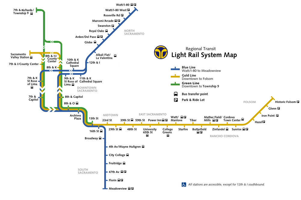
English: Author is self. Map of the Sacramento RT light rail system based on the official map at:
http://www.sacrt.com/schedules/current/maps/R519.gif |
| Date | 21 November 2008 (original upload date) |
| Source | http://www.sacrt.com/schedules/current/maps/R519.gif |
| Author | CountZ at English Wikipedia |

|
This transport map image could be re-created using vector graphics as an SVG file. This has several advantages; see Commons:Media for cleanup for more information. If an SVG form of this image is available, please upload it and afterwards replace this template with
{{vector version available|new image name}}.
It is recommended to name the SVG file “Sacramento RT light rail map.svg”—then the template Vector version available (or Vva) does not need the new image name parameter. |
Licensing
CountZ at English Wikipedia, the copyright holder of this work, hereby publishes it under the following license:
This file is licensed under the Creative Commons Attribution-Share Alike 3.0 Unported license.
Attribution: CountZ at English Wikipedia
- You are free:
- to share – to copy, distribute and transmit the work
- to remix – to adapt the work
- Under the following conditions:
- attribution – You must give appropriate credit, provide a link to the license, and indicate if changes were made. You may do so in any reasonable manner, but not in any way that suggests the licensor endorses you or your use.
- share alike – If you remix, transform, or build upon the material, you must distribute your contributions under the same or compatible license as the original.
Original upload log
Transferred from en.wikipedia to Commons by Howchou using CommonsHelper.
The original description page was here. All following user names refer to en.wikipedia.
- 2012-06-24 07:26 Shadowlink1014 1001×667× (42035 bytes) Tweak PNG transparency dither settings so that "Green Line" doesn't pixelate. Also note that this newer version removes the central city fare zone, since that has been abolished.
- 2012-06-24 07:24 Shadowlink1014 1001×667× (41741 bytes) Added Green Line, updated stations that have been moved downtown, updated parking and bus connections for some outlying stations.
- 2008-11-21 01:57 CountZ 1001×667× (148579 bytes) Author is self. Map of the Sacramento RT light rail system based on the official map at: http://www.sacrt.com/schedules/current/maps/R533.gif
File history
Click on a date/time to view the file as it appeared at that time.
| Date/Time | Thumbnail | Dimensions | User | Comment | |
|---|---|---|---|---|---|
| current | 16:11, 20 January 2013 | | 1,001 × 667 (41 KB) | File Upload Bot (Magnus Manske) | Transfered from en.wikipedia by User:howchou using CommonsHelper |
File usage
The following pages on the English Wikipedia use this file (pages on other projects are not listed):
Global file usage
The following other wikis use this file:
- Usage on es.wikipedia.org
- Usage on fa.wikipedia.org
- Usage on nl.wikipedia.org
- Usage on www.wikidata.org
- Usage on zh.wikipedia.org