No higher resolution available.
SPC_1630_UTC_outlook_with_watches_and_radar_3-31-2023.gif (582 × 408 pixels, file size: 154 KB, MIME type: image/gif, looped, 7 frames, 3.5 s)
| This is a file from the Wikimedia Commons. Information from its description page there is shown below. Commons is a freely licensed media file repository. You can help. |
Summary
| Description |
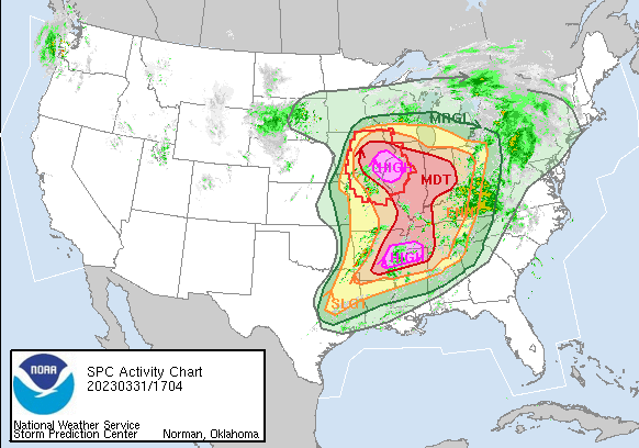
English: The SPC 1630 UTC outlook for 3/31/2023 with the watches and radar imagery overlayed.
  "...THERE IS A HIGH RISK OF SEVERE THUNDERSTORMS FOR FAR SOUTHEAST
  IOWA...WEST-CENTRAL ILLINOIS...FAR NORTHEAST MISSOURI AND IN PARTS
  OF EASTERN ARKANSAS...NORTHERN MISSISSIPPI...AND SOUTHWESTERN
  TENNESSEE...
...SUMMARY... A severe weather outbreak appears increasingly likely, centered on this afternoon and evening, across a large portion of the Mississippi Valley. At least a few long-track, strong to potentially violent tornadoes are probable, particularly over portions of the Mid-Mississippi Valley to the Mid-South. Swaths of intense damagingwind gusts along with very large hail are expected as well." |
| Date | |
| Source | https://www.spc.noaa.gov/ |
| Author | Storm Prediction Center |
Licensing
This image is in the public domain because it was stored on the web servers of the U.S. National Weather Service. NWS-created images are automatically public domain in the U.S. since the NWS is a part of the U.S. government. However, the NWS sites also host non-NWS images which have been submitted by individuals: these are generally shown as "Courtesy of ...". Such images have explicitly been released to the public domain by the copyright owner as part of the upload process.
As stated at https://www.weather.gov/fsd/disclaimer: "By submitting images, you understand that your image is being released into the public domain. This means that your photo or video may be downloaded, copied, and used by others." Thus, all* images on NWS servers are public domain (including "Courtesy of ..." and “Photo by ...” images) unless specifically stated otherwise through a copyright (©) watermark.
*A deletion discussion in November 2023 ruled that Getty Images on the web servers of NWS, are to be considered copyrighted, even without a copyright (©) watermark and are the sole exception to this rule.
|
File history
Click on a date/time to view the file as it appeared at that time.
| Date/Time | Thumbnail | Dimensions | User | Comment | |
|---|---|---|---|---|---|
| current | 03:23, 1 April 2023 | | 582 × 408 (154 KB) | ChessEric | Uploaded a work by Storm Prediction Center from https://www.spc.noaa.gov/ with UploadWizard |
File usage
The following pages on the English Wikipedia use this file (pages on other projects are not listed):