
Size of this preview: 800 × 530 pixels. Other resolutions: 320 × 212 pixels | 640 × 424 pixels | 1,024 × 678 pixels | 1,477 × 978 pixels.
Original file (1,477 × 978 pixels, file size: 239 KB, MIME type: image/jpeg)
| Description |
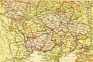
Scan from Blackie & Sons Atlas (Edinburgh, 1882), Scale: 1:6,100,000 (or one inch = about 96 miles) | ||
|---|---|---|---|
| Source |
| ||
| Date | |||
| Author |
| ||
| Permission (Reusing this file) |
See below.
|
| This file is in the public domain because its copyright has expired in the United States and those countries with a copyright term of no more than the life of the author plus 100 years.
|
| The uploader or another editor requests that a local copy of this file be kept. This image or media file may be available on the Wikimedia Commons as File:Russian Empire Southwest 1882.jpg. While the license of this file may be compliant with the Wikimedia Commons, an editor has requested that the local copy be kept too. This file does not meet CSD F8 and should not be tagged as a Commons duplicate. If you desire to nominate it for deletion, notify the tagging editor. |
| This media file is either in the public domain or published under a free license, and contains no inbound file links. If this media file is useful, then it should be transferred to the Wikimedia Commons. If this media is not useful, then please propose it for deletion or list it at files for discussion. |
File history
Click on a date/time to view the file as it appeared at that time.
| Date/Time | Thumbnail | Dimensions | User | Comment | |
|---|---|---|---|---|---|
| current | 04:08, 27 April 2008 | | 1,477 × 978 (239 KB) | Irpen (talk | contribs) | Scan from Blackie & Sons Atlas (Edinburgh, 1882), Scale: 1:6,100,000 (or one inch = about 96 miles) *Found at http://old-map.narod.ru/e4.html where referenced to http://feefhs.org/maps/ruse/re-ukrai.html {{PD-Old}} {{KeepLocal}} |
You cannot overwrite this file.
File usage
No pages on the English Wikipedia use this file (pages on other projects are not listed).