
Size of this preview: 800 × 600 pixels. Other resolutions: 320 × 240 pixels | 640 × 480 pixels | 1,024 × 768 pixels | 1,280 × 960 pixels | 1,984 × 1,488 pixels.
Original file (1,984 × 1,488 pixels, file size: 1.07 MB, MIME type: image/jpeg)
| This is a file from the Wikimedia Commons. Information from its description page there is shown below. Commons is a freely licensed media file repository. You can help. |
Summary
| Description |
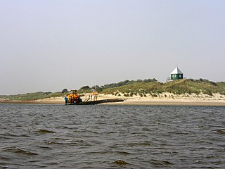
Nederlands: Rottumerplaat vanuit zee - de observatietoren is al van verre beeldbepalend voor het eiland. De shovel wordt gebruikt om bagage te vervoeren van en naar de sloep die wordt gebruikt om naar het eiland te komen.
English: The Dutch island of "Rottumerplaat" seen from the sea - the observation tower dominates the view of the island from quite a long way away. The shovel is used to move luggage into and out of the small boat that is used to take people to and from the island. |
| Date | |
| Source | Own work |
| Author | Sphinx |
| Camera location | | View this and other nearby images on: OpenStreetMap |
|---|
Licensing
I, the copyright holder of this work, hereby publish it under the following licenses:

|
Permission is granted to copy, distribute and/or modify this document under the terms of the GNU Free Documentation License, Version 1.2 or any later version published by the Free Software Foundation; with no Invariant Sections, no Front-Cover Texts, and no Back-Cover Texts. A copy of the license is included in the section entitled GNU Free Documentation License. |
This file is licensed under the Creative Commons Attribution-Share Alike 3.0 Unported, 2.5 Generic, 2.0 Generic and 1.0 Generic license.
- You are free:
- to share – to copy, distribute and transmit the work
- to remix – to adapt the work
- Under the following conditions:
- attribution – You must give appropriate credit, provide a link to the license, and indicate if changes were made. You may do so in any reasonable manner, but not in any way that suggests the licensor endorses you or your use.
- share alike – If you remix, transform, or build upon the material, you must distribute your contributions under the same or compatible license as the original.
You may select the license of your choice.
File history
Click on a date/time to view the file as it appeared at that time.
| Date/Time | Thumbnail | Dimensions | User | Comment | |
|---|---|---|---|---|---|
| current | 19:59, 11 October 2013 | | 1,984 × 1,488 (1.07 MB) | Jahoe | levels |
| 12:29, 7 October 2007 |  | 1,984 × 1,488 (621 KB) | Itsme | {{Information |Description=Rottumerplaat vanuit zee - de observatietoren is al van verre beeldbepalend voor het eiland. / Rottumerplaat from sea - the obsservation tower determines the image of the island already from far away. |Source=eigen werk / own wo |
File usage
The following pages on the English Wikipedia use this file (pages on other projects are not listed):
Global file usage
The following other wikis use this file:
- Usage on ar.wikipedia.org
- Usage on de.wikipedia.org
- Usage on es.wikipedia.org
- Usage on fy.wikipedia.org
- Usage on it.wikipedia.org
- Usage on li.wikipedia.org
- Usage on nl.wikipedia.org
- Usage on no.wikipedia.org
- Usage on stq.wikipedia.org
- Usage on tr.wikipedia.org