
Size of this preview: 800 × 507 pixels. Other resolutions: 320 × 203 pixels | 640 × 405 pixels | 1,024 × 648 pixels | 1,280 × 811 pixels | 2,560 × 1,621 pixels | 5,882 × 3,725 pixels.
Original file (5,882 × 3,725 pixels, file size: 4.54 MB, MIME type: image/jpeg)
| This is a file from the Wikimedia Commons. Information from its description page there is shown below. Commons is a freely licensed media file repository. You can help. |
Summary
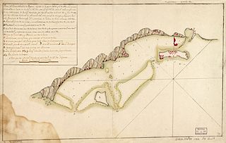
| Description | A map of the (now) Honduran isle of Roatán. The map was probably made by a Spanish military engineer after the 1782 Battle of Roatán. | ||
| Date | |||
| Source |
|
||
| Author | Unknown author |

Licensing
|
This work is in the public domain in its country of origin and other countries and areas where the copyright term is the author's life plus 100 years or fewer. | |
| This file has been identified as being free of known restrictions under copyright law, including all related and neighboring rights. | |
File history
Click on a date/time to view the file as it appeared at that time.
| Date/Time | Thumbnail | Dimensions | User | Comment | |
|---|---|---|---|---|---|
| current | 22:37, 30 November 2010 | | 5,882 × 3,725 (4.54 MB) | Magicpiano | {{Information |Description=A map of the (now) Honduran isle of Roatán. The map was probably made by a Spanish military engineer after the 1782 w:Battle of Roatán. |Source={{LOC-map|division=gmd|id=lh000495}} |Date=1782 |Author=unknow |
File usage
The following pages on the English Wikipedia use this file (pages on other projects are not listed):
Global file usage
The following other wikis use this file:
- Usage on es.wikipedia.org
- Usage on fi.wikipedia.org
- Usage on it.wikipedia.org
- Usage on ru.wikipedia.org
- Usage on www.wikidata.org