No higher resolution available.
Ragwort_and_woods_near_Abermawr_-_geograph.org.uk_-_1441780.jpg (640 × 480 pixels, file size: 116 KB, MIME type: image/jpeg)
| This is a file from the Wikimedia Commons. Information from its description page there is shown below. Commons is a freely licensed media file repository. You can help. |
Summary
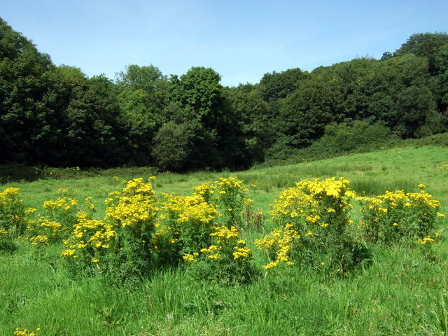
| Description |
English: Ragwort and woods near Abermawr A fine stand of this much-maligned plant. Ragwort (Senecio jacobae) has received an enormous amount of condemnation from the horseloving community on account of its toxicity; in fact much of the negative publicity is based on myth and misinformation and its destruction usually does more harm than good (see http://www.ragwortfacts.com/)
Ragwort is a foodplant for around 30 insect species and others are attracted by its nectar. This particular clump was host to Painted Lady and Small Copper butterflies, honey and other bees, hoverflies and many more. |
| Date | |
| Source | From geograph.org.uk |
| Author | ceridwen |
| Attribution (required by the license) | ceridwen / Ragwort and woods near Abermawr / |
| Camera location | | View this and other nearby images on: OpenStreetMap |
|---|
_heading:22.00&language=en)
| Object location | | View this and other nearby images on: OpenStreetMap |
|---|
_heading:22.00&language=en)
Licensing

|
This image was taken from the Geograph project collection. See this photograph's page on the Geograph website for the photographer's contact details. The copyright on this image is owned by ceridwen and is licensed for reuse under the Creative Commons Attribution-ShareAlike 2.0 license.
|
This file is licensed under the Creative Commons Attribution-Share Alike 2.0 Generic license.
Attribution: ceridwen
- You are free:
- to share – to copy, distribute and transmit the work
- to remix – to adapt the work
- Under the following conditions:
- attribution – You must give appropriate credit, provide a link to the license, and indicate if changes were made. You may do so in any reasonable manner, but not in any way that suggests the licensor endorses you or your use.
- share alike – If you remix, transform, or build upon the material, you must distribute your contributions under the same or compatible license as the original.
File history
Click on a date/time to view the file as it appeared at that time.
| Date/Time | Thumbnail | Dimensions | User | Comment | |
|---|---|---|---|---|---|
| current | 02:49, 2 March 2011 | | 640 × 480 (116 KB) | GeographBot | == {{int:filedesc}} == {{Information |description={{en|1=Ragwort and woods near Abermawr A fine stand of this much-maligned plant. Ragwort (Senecio jacobae) has received an enormous amount of condemnation from the horseloving community on account of its t |
File usage
No pages on the English Wikipedia use this file (pages on other projects are not listed).
Global file usage
The following other wikis use this file:
- Usage on sv.wikipedia.org