
Size of this preview: 783 × 600 pixels. Other resolutions: 313 × 240 pixels | 627 × 480 pixels | 1,002 × 768 pixels | 1,280 × 981 pixels | 2,560 × 1,962 pixels | 3,850 × 2,950 pixels.
Original file (3,850 × 2,950 pixels, file size: 6.31 MB, MIME type: image/jpeg)
| This is a file from the Wikimedia Commons. Information from its description page there is shown below. Commons is a freely licensed media file repository. You can help. |
Summary
| Description |
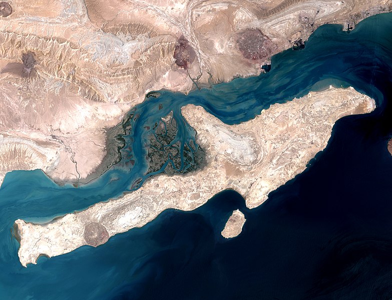
English: Qeshm Island in the Strait of Hormuz, Iran. This image is a combination of two images acquired by the Enhanced Thematic Mapper on NASA’s Landsat 7 satellite
فارسی: تصویر ماهوارهای از جزیرهٔ قشم در تنگهٔ هرمز |
| Date | |
| Source | http://earthobservatory.nasa.gov/IOTD/view.php?id=7460 |
| Author | NASA image using data provided courtesy of the University of Maryland’s Global Land Cover Facility |
|
This image was selected as picture of the day on Wikimedia Commons for 26 May 2013. It was captioned as follows: English: Qeshm Island in the Strait of Hormuz, Iran. This image is a combination of two images acquired by the Enhanced Thematic Mapper on NASA’s Landsat 7 satellite. Other languages:
English: Qeshm Island in the Strait of Hormuz, Iran. This image is a combination of two images acquired by the Enhanced Thematic Mapper on NASA’s Landsat 7 satellite. Italiano: Isola di Qeshm nello stretto di Hormuz, Iran. Quest'immagine è la combinazione di due foto scattate dall'Enhanced Thematic Mapper Plus installto sul satellite Landsat 7. Magyar: Qeshm-sziget, Irán (A kép a Landsat 7 NASA műhold két képének kombinációjával készült.) Nederlands: Het eiland Qishm in de Straat van Hormuz, Iran. De foto is een combinatie van twee afbeeldingen door NASA’s Landsat 7-satelliet. Русский: Остров Кешм, вид из космоса. 中文: 伊朗霍尔木兹海峡格什姆岛。 |
Licensing
| This file is in the public domain in the United States because it was solely created by NASA. NASA copyright policy states that "NASA material is not protected by copyright unless noted". (See Template:PD-USGov, NASA copyright policy page or JPL Image Use Policy.) | ||
 |
Warnings:
|
| Annotations | This image is annotated: View the annotations at Commons |
File history
Click on a date/time to view the file as it appeared at that time.
| Date/Time | Thumbnail | Dimensions | User | Comment | |
|---|---|---|---|---|---|
| current | 00:20, 28 May 2013 | | 3,850 × 2,950 (6.31 MB) | Lucassosa7 | modificacion de curvas |
| 07:36, 27 July 2009 |  | 3,850 × 2,950 (2.7 MB) | Telim tor | == Summary == {{Information |Description= {{en|Strait of Hormuz with Qeshm Island, Iran. This image is a combination of two images acquired by the Enhanced Thematic Mapper on NASA’s Landsat 7 satellite}} |Source=http://earthobservatory.nasa.gov/IOTD/vie |
File usage
The following pages on the English Wikipedia use this file (pages on other projects are not listed):
Global file usage
The following other wikis use this file:
- Usage on ar.wikipedia.org
- Usage on arz.wikipedia.org
- Usage on az.wikipedia.org
- Usage on be-tarask.wikipedia.org
- Usage on be.wikipedia.org
- Usage on bn.wikipedia.org
- Usage on bn.wikibooks.org
- Usage on bs.wikipedia.org
- Usage on ca.wikipedia.org
- Usage on ceb.wikipedia.org
- Usage on crh.wikipedia.org
- Usage on cs.wikipedia.org
- Usage on cv.wikipedia.org
- Usage on de.wikipedia.org
- Usage on de.wikivoyage.org
- Usage on el.wikipedia.org
- Usage on en.wikivoyage.org
- Usage on es.wikipedia.org
- Wikipedia:Imágenes destacadas/Lugares/Asia
- Qeshm
- Wikipedia:Recurso del día/801 - 900
- Áreas protegidas de Irán
- Wikipedia:Candidatos a recursos destacados/QeshmIsland NASA.jpg
- Wikipedia:Candidatos a recursos destacados/Febrero-2021
- Plantilla:RDD/855
- Wikipedia:Recurso del día/marzo de 2021
- Wikipedia:Recurso del día/febrero de 2023
- Usage on eu.wikipedia.org
- Usage on fa.wikipedia.org
- جزیره قشم
- شهرستان قشم
- ویکیپدیا:گزیدن نگاره برگزیده/دسامبر-۲۰۱۲
- ویکیپدیا:نگارههای پیشنهادی/ایران
- ویکیپدیا:نگاره روز/آوریل ۲۰۱۳
- ویکیپدیا:گزیدن نگاره برگزیده/QeshmIsland NASA.jpg
- الگو:نر/2013-04-30
- الگو:نر محافظت شده/2013-04-30
- درگاه:ناسا/نگاره برگزیده/۵
- درگاه:ناسا/نگاره برگزیده
- ویکیپدیا:نگارههای برگزیده/نگاه به زمین
- بحث کاربر:Magic Wizard/بایگانی ۱
- ویکیپدیا:نگاره روز/ژوئن ۲۰۱۹
- تنگه خوران
- الگو:نر/2019-06-26
View more global usage of this file.