Original file (549 × 800 pixels, file size: 148 KB, MIME type: image/jpeg)
| This is a file from the Wikimedia Commons. Information from its description page there is shown below. Commons is a freely licensed media file repository. You can help. |
Summary
| Description |
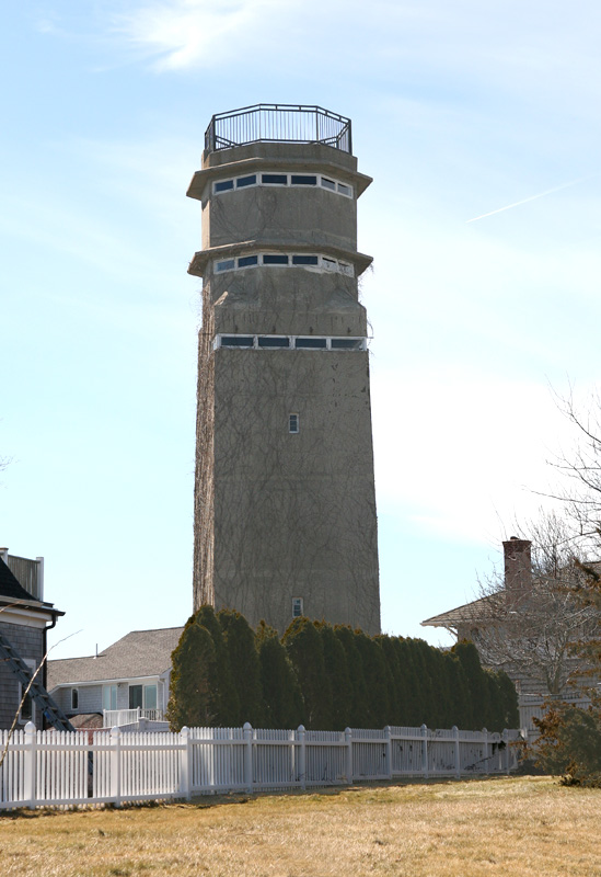
English: This 7-story fire control tower, photographed in 2009 (looking WSW), is located on Pt. Allerton, in Hull, MA. It is the highest in the Boston Harbor Defense fire control system. It survives in the back yard of a private residence, in almost mint condition, visible throughout Hull, and looking out over miles and miles of coastline and ocean. A detailed description of the tower is contained here.
The top three stories of the tower were used for observation. Each story held a base end station, and each mounted a DPF (Depression Position Finder), as well as a spotting scope. The top level DPF, at 179 feet, controlled fire for Battery Murphy, the 16-inch guns in Nahant. Next came the 6th story, at 171 feet, which controlled Battery Jewell, the 6-inch guns a short distance to the north, on Outer Brewster Island. Then came the fifth story, at 163 feet, which controlled fire for Battery 207, the 6-inch guns across the harbor entrance at Ft. Dawes. A concrete crow's nest "basket" was located just below the roof level, with a trapdoor that opened up and provided space for an observer of the Ant-Aircraft Intelligence Service (AAIS) who stood watches spotting for intruding aircraft. The railing around the edge of the roof was added (for the safety of visitors) by the present (2010) owner, who also installed a new staircase to the roof through the former AAIS crow's nest. |
| Date | 12 May 2010 (original upload date) |
| Source | Own work |
| Author | Pgrig at English Wikipedia |
Licensing
- You are free:
- to share – to copy, distribute and transmit the work
- to remix – to adapt the work
- Under the following conditions:
- attribution – You must give appropriate credit, provide a link to the license, and indicate if changes were made. You may do so in any reasonable manner, but not in any way that suggests the licensor endorses you or your use.
- share alike – If you remix, transform, or build upon the material, you must distribute your contributions under the same or compatible license as the original.
Original upload log
Transferred from en.wikipedia to Commons by Ktr101 using CommonsHelper.
- 2010-05-12 18:39 Pgrig 549×800× (151356 bytes) This 7-story fire control tower, photographed in 2009, is located on Pt. Allerton, in Hull, MA. It is the highest in the Boston Harbor Defense fire control system. It survives in the back yard of a private residence, in almost mint condition, visible thro
File history
Click on a date/time to view the file as it appeared at that time.
| Date/Time | Thumbnail | Dimensions | User | Comment | |
|---|---|---|---|---|---|
| current | 00:14, 30 June 2013 | | 549 × 800 (148 KB) | Ktr101 | {{Information |Description={{en|This 7-story fire control tower, photographed in 2009 (looking WSW), is located on Pt. Allerton, in Hull, MA. It is the highest in the Boston Harbor Defense fire control system. It survives in the back yard of a private ... |