
Original file (6,048 × 4,120 pixels, file size: 8.4 MB, MIME type: image/jpeg)
| This is a file from the Wikimedia Commons. Information from its description page there is shown below. Commons is a freely licensed media file repository. You can help. |
Summary
- From portuguese wikipedia José Manuel CH--GE 14:34, 9 Novembro 2005 (UTC)
| Description |
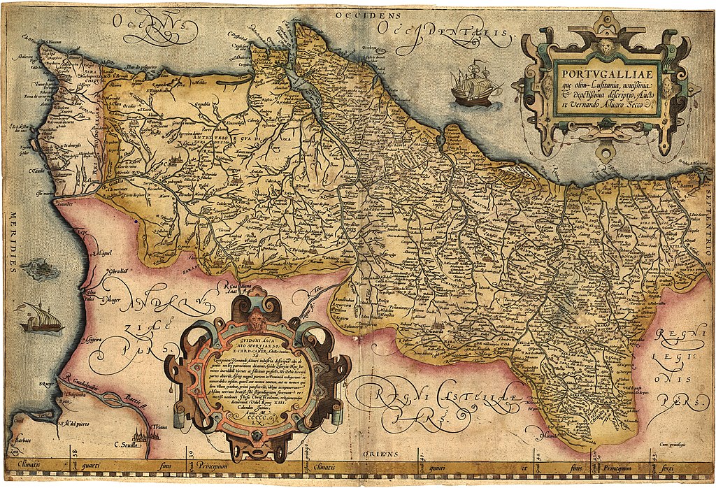
English: Portugalliae que olim Lusitania, novissima & exactissima descriptio. [1] Adaptation in the "Theatrum Orbis Terrarum" (1570) de Abraham Ortelius from the alleged first map of Portugal (1560) by Álvaro Seco. Português: Portugalliae que olim Lusitania, novissima & exactissima descriptio. [2] é provavelmente o primeiro mapa de Portugal. Feito por Álvaro Seco é provavelmente publicado em Roma por volta de 1560 com o título "Tabula Geografica Portugalliae". |
| Date | |
| Source | Own work |
| Author | Jose Manuel |
| Other versions |
|
-JM_(pormenor_com_Troia).jpg)
_-_Geographicus_-_Portugalliae-ortelius-1587.jpg)


-JM.jpg)
-JM.jpg&action=edit&redlink=1)
-JM.jpg)
Licensing
|
This work is in the public domain in its country of origin and other countries and areas where the copyright term is the author's life plus 70 years or fewer.
| |
| This file has been identified as being free of known restrictions under copyright law, including all related and neighboring rights. | |
File history
Click on a date/time to view the file as it appeared at that time.
| Date/Time | Thumbnail | Dimensions | User | Comment | |
|---|---|---|---|---|---|
| current | 06:01, 13 December 2018 | | 6,048 × 4,120 (8.4 MB) | SteinsplitterBot | Bot: Image rotated by 90° |
| 00:34, 11 August 2012 |  | 4,120 × 6,054 (8.42 MB) | Jose Manuel | Best vertical photo resolution and sharp | |
| 23:04, 10 August 2012 |  | 6,054 × 4,120 (21.47 MB) | Jose Manuel | Best photo resolution and sharp | |
| 15:26, 9 November 2005 |  | 403 × 600 (94 KB) | Nuno Tavares | ;'''Description:''' :{{português}}: '' Portugalliae 1561 (Baseado no primeiro mapa de Portugal) " ;'''Source/Credits:''' : {{português}}: Fotografias Imagens ilustrações do usuário registrado. (''Não protegidos por copyright''). <br> :: Igualmente p |
File usage
Global file usage
The following other wikis use this file:
- Usage on an.wikipedia.org
- Usage on azb.wikipedia.org
- Usage on be.wikipedia.org
- Usage on ca.wikipedia.org
- Usage on cs.wikipedia.org
- Usage on de.wikipedia.org
- Usage on eo.wikipedia.org
- Usage on es.wikipedia.org
- Usage on eu.wikipedia.org
- Usage on fr.wikipedia.org
- Usage on ga.wikipedia.org
- Usage on gl.wikipedia.org
- Usage on id.wikipedia.org
- Usage on it.wikipedia.org
- Usage on ml.wikipedia.org
- Usage on ms.wikipedia.org
- Usage on nl.wikipedia.org
- Usage on nn.wikipedia.org
- Usage on oc.wikipedia.org
- Usage on pl.wikipedia.org
- Usage on pt.wikipedia.org
- Usage on ru.wikipedia.org
- Usage on sk.wikipedia.org
- Usage on sv.wikipedia.org
- Usage on uk.wikipedia.org
- Usage on vi.wikipedia.org
- Usage on www.wikidata.org
- Usage on zh.wikipedia.org
-JM.jpg)