File:Political map of Canada ar.png

Political_map_of_Canada_ar.png (693 × 599 pixels, file size: 147 KB, MIME type: image/png)

Description
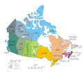
English: A map of Canada exhibiting its ten provinces and three territories, and their capitals. (Lambert conformal conic projection from The Atlas of Canada)
Date (UTC)
Source
Author
This is a retouched picture, which means that it has been digitally altered from its original version. Modifications: translated to arabic. The original can be viewed here: Political map of Canada.png. Modifications made by Bassem.

I, the copyright holder of this work, hereby publish it under the following license:
This work has been released into the public domain by its author, Example, at the [[::|English Wikipedia]] project. This applies worldwide.

In case this is not legally possible:
Example grants anyone the right to use this work for any purpose, without any conditions, unless such conditions are required by law.

Original upload log

This image is a derivative work of the following images:

  • File:Political_map_of_Canada.png licensed with PD-user-w
    • 2007-06-13T02:50:40Z Andrew pmk 1280x1107 (250520 Bytes) optimize png
    • 2007-06-06T01:38:46Z Andrew pmk 1280x1107 (250520 Bytes) optimize png
    • 2006-06-06T09:35:23Z Kaveh 1280x1107 (302665 Bytes) == Summary == [[Canada]]: political map – depicting |provinces/territories and capital cities. Drawn and adapted by [[:en:User:E Pluribus Anthony|E Pluribus Anthony]] from [http://atlas.gc.ca/site/english/maps/reference/n

Uploaded with derivativeFX

Annotations
InfoField
This image is annotated: View the annotations at Commons

Captions

Add a one-line explanation of what this file represents

Items portrayed in this file

depicts

image/png

150,797 byte

599 pixel

693 pixel

add6e0b560bff0e752a9c1c03cdced25e0f0afc7

File history

Click on a date/time to view the file as it appeared at that time.

Date/TimeThumbnailDimensionsUserComment
current15:54, 19 January 2011Thumbnail for version as of 15:54, 19 January 2011693 × 599 (147 KB)باسمGrammatical correction
15:51, 19 January 2011Thumbnail for version as of 15:51, 19 January 2011693 × 599 (147 KB)باسمGrammatical correction
15:21, 19 January 2011Thumbnail for version as of 15:21, 19 January 2011693 × 599 (147 KB)باسمGrammatical corrections
16:05, 2 December 2010Thumbnail for version as of 16:05, 2 December 2010693 × 599 (148 KB)باسم{{Information |Description={{en|1=A map of Canada exhibiting its ten provinces and three territories, and their capitals. (Lambert conformal conic projection from [http://atlas.gc.ca/site/english/maps/reference/national/can_political_e The Atlas of Canada
No pages on the English Wikipedia use this file (pages on other projects are not listed).

Global file usage

The following other wikis use this file: