
Size of this PNG preview of this SVG file: 600 × 600 pixels. Other resolutions: 240 × 240 pixels | 480 × 480 pixels | 768 × 768 pixels | 1,024 × 1,024 pixels | 2,048 × 2,048 pixels | 1,530 × 1,530 pixels.
Original file (SVG file, nominally 1,530 × 1,530 pixels, file size: 8.93 MB)
| This is a file from the Wikimedia Commons. Information from its description page there is shown below. Commons is a freely licensed media file repository. You can help. |
Summary
| Title |
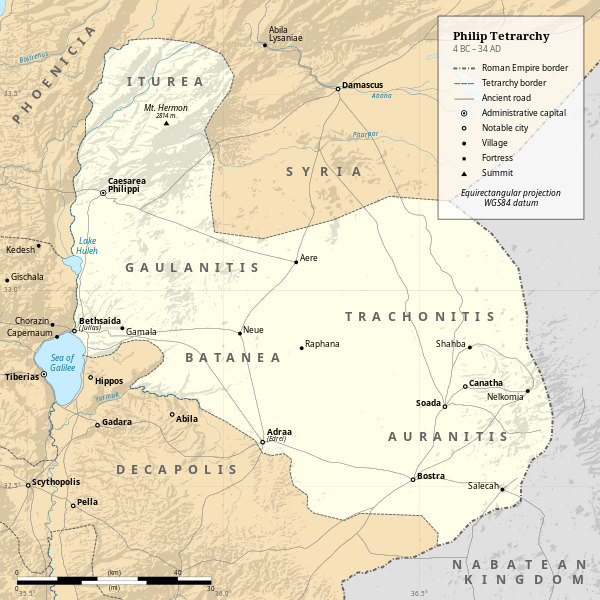
Philip Tetrarchy political map (4 BC – 34 AD) |
|||||||||
| Description |
English: Philip Tetrarchy political map (4 BC – 34 AD) |
|||||||||
| Date | ||||||||||
| Source |
Own work. This file was derived from: Herodian Tetrarchy political map.svg:
|
|||||||||
| Creator | ||||||||||
| Geotemporal data | ||||||||||
| Date depicted | 4 BC – 39 AD | |||||||||
| Map location | Southern Levant | |||||||||
| Map type | Political map | |||||||||
| Spatial reference system | Equirectangular projection - WGS84 datum | |||||||||
| Heading |
 |
|||||||||
| Bounding box |
|
|||||||||
| Georeferencing | If inappropriate please set warp_status = skip to hide. | |||||||||
| Bibliographic data | ||||||||||
| Language | English | |||||||||
| Other versions |
|
|||||||||

Licensing
I, the copyright holder of this work, hereby publish it under the following license:
This file is licensed under the Creative Commons Attribution-Share Alike 4.0 International license.
- You are free:
- to share – to copy, distribute and transmit the work
- to remix – to adapt the work
- Under the following conditions:
- attribution – You must give appropriate credit, provide a link to the license, and indicate if changes were made. You may do so in any reasonable manner, but not in any way that suggests the licensor endorses you or your use.
- share alike – If you remix, transform, or build upon the material, you must distribute your contributions under the same or compatible license as the original.
File history
Click on a date/time to view the file as it appeared at that time.
| Date/Time | Thumbnail | Dimensions | User | Comment | |
|---|---|---|---|---|---|
| current | 18:44, 3 January 2024 | | 1,530 × 1,530 (8.93 MB) | DEGA MD | Uploaded own work with UploadWizard |
File usage
The following pages on the English Wikipedia use this file (pages on other projects are not listed):