
Size of this preview: 800 × 395 pixels. Other resolutions: 320 × 158 pixels | 640 × 316 pixels | 1,024 × 505 pixels | 1,280 × 631 pixels | 2,082 × 1,027 pixels.
Original file (2,082 × 1,027 pixels, file size: 2.86 MB, MIME type: image/png)
| This is a file from the Wikimedia Commons. Information from its description page there is shown below. Commons is a freely licensed media file repository. You can help. |
Summary
| Description |
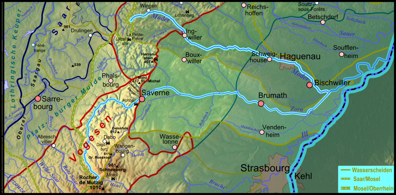
Deutsch: Karte des Flussgebietes des elsässischen Moder-Nebenflusses Zorn, südlicher Hauptarm der Moder Français : Carte du bassin hydrographique de la Zorn en Alsace et en Moselle. |
| Date | |
| Source |
Own work
|
| Author | Elop |
| Other versions |
|
Licensing

|
Permission is granted to copy, distribute and/or modify this document under the terms of the GNU Free Documentation License, Version 1.2 or any later version published by the Free Software Foundation; with no Invariant Sections, no Front-Cover Texts, and no Back-Cover Texts. A copy of the license is included in the section entitled GNU Free Documentation License. |
File history
Click on a date/time to view the file as it appeared at that time.
| Date/Time | Thumbnail | Dimensions | User | Comment | |
|---|---|---|---|---|---|
| current | 20:57, 18 January 2012 | | 2,082 × 1,027 (2.86 MB) | Elop | == Summary == {{Information |Description ={{de|1=Karte des Flussgebietes der elsässischen Moder]- Nebenflusses [[:de:Zorn (Fluss)|Zorn, südlicher Hauptarm der Moder}} |Source ={{own}} *New relief: [http:/ |
File usage
The following pages on the English Wikipedia use this file (pages on other projects are not listed):
Global file usage
The following other wikis use this file:
- Usage on als.wikipedia.org
- Usage on de.wikipedia.org
- Usage on fr.wikipedia.org
- Usage on nl.wikipedia.org
- Usage on simple.wikipedia.org
- Usage on sr.wikipedia.org
- Usage on www.wikidata.org